|
October 17, 1805 Side-Trip Up the Columbia River - Tri-Cities and the Yakima River |
|
Home
The Volcanoes of Lewis and Clark Map of the Journey Volcanoes, Basalt Plateaus, Major Rivers, etc. The Volcanoes Mount Adams, Mount Hood, Mount Jefferson, Mount Rainier, and Mount St. Helens CALENDAR of the Journey October 1805 to June 1806 Along the Journey Pacific Northwest Maps - Columbia River, Volcanoes, Flood Basalts, Missoula Floods, Geology, etc. The Corps of Discovery The Journey of Lewis and Clark About the Reference Materials The Journals, Biddle/Allen, DeVoto, Gass, Moulton, Topo Maps, and others USGS Lewis and Clark Links Links to USGS Websites highlighting the Lewis and Clark Journey Resources Publications Referenced and Websites Visited |
PREVIOUS
October 16 Reaching the "Great Columbia", Snake/Columbia Confluence |
October 17
Side-Trip Up the Columbia, Tri-Cities and the Yakima River Junction of the Snake River with the Columbia River, Columbia River, Snake River, Horse Heaven Hills, Blue Mountains, Yakima River, Up the Columbia, Clover Island and the Pasco-Kennewick Bridges, Bateman Island, Sacajawea State Park |
CONTINUE
October 18 Down the "Great Columbia", Snake/Columbia Confluence to Spring Gulch |
On October 7, 1805, Lewis and Clark and the
"Corps of Discovery" began their journey
down the Clearwater River and into the volcanics
of the Pacific Northwest. The Corps travelled from the
Clearwater to the Snake and down the
"Great Columbia", finally reaching the
Pacific Ocean on November 15, 1805.
Along the journey they encountered the
lava flows of the Columbia Plateau,
river channels carved by the great "Missoula Floods",
and the awesome beauty of five Cascade Range volcanoes.

[Click map for brief summary about the area] |
|
To the Pacific - October 1805
Side-Trip Up the Columbia River - Tri-Cities and the Yakima River |
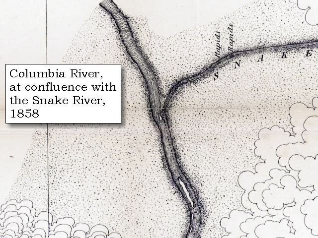
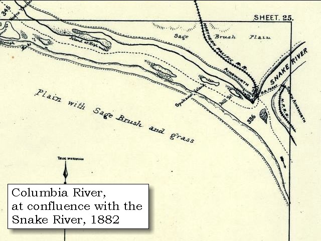
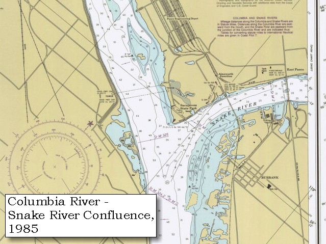
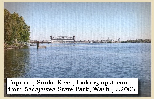
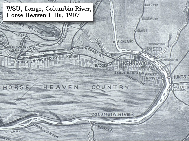
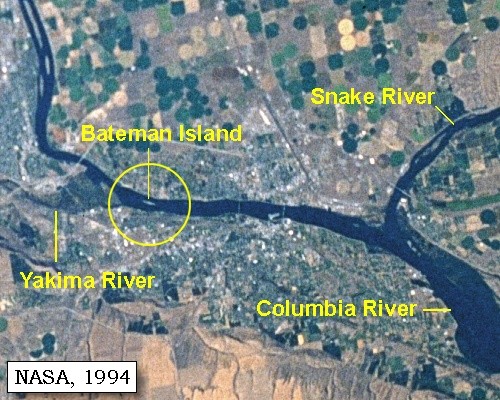
| Lewis and Clark's camp of October 16 and 17, 1805, was at the confluence of the Snake and Columbia Rivers, just east of Pasco, Washington. Today Sacajawea State Park is located at this junction. The original campsite is now under the waters of Lake Wallula, behind McNary Dam. On October 17, Captain Clark takes a journey of 10 miles, reaching Bateman Island, the furthest upstream on the Columbia River the Lewis and Clark expedition visited. |
| Thursday, October 17, 1805 |
| The day being fair we were occupied in making the necessary observations for determining our longitude, and obtained a meridian altitude, from which it appeared that we were in latitude 46o 15' 13";. We also measured the two rivers by angles, and found that at the junction the Columbia [Columbia River] is nine hundred and sixty yards wide, and Lewis's river [Snake River] five hundred and seventy-five; but soon after they unite, the former widens to the space of from one to three miles, including the islands. |
|
|
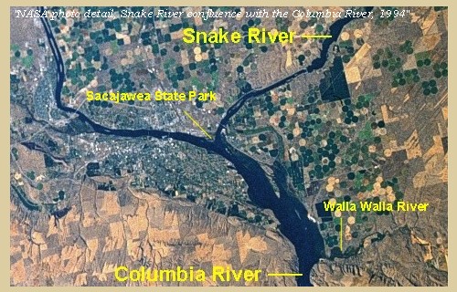
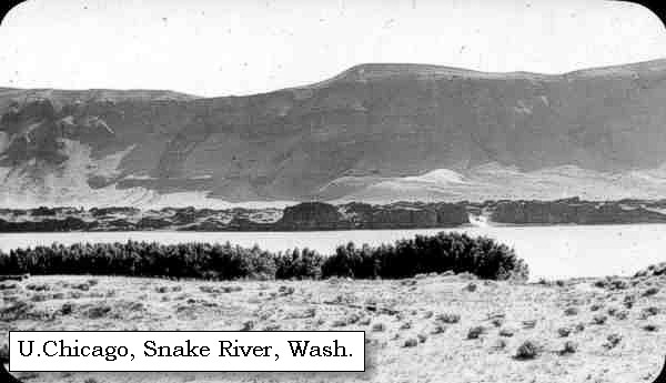
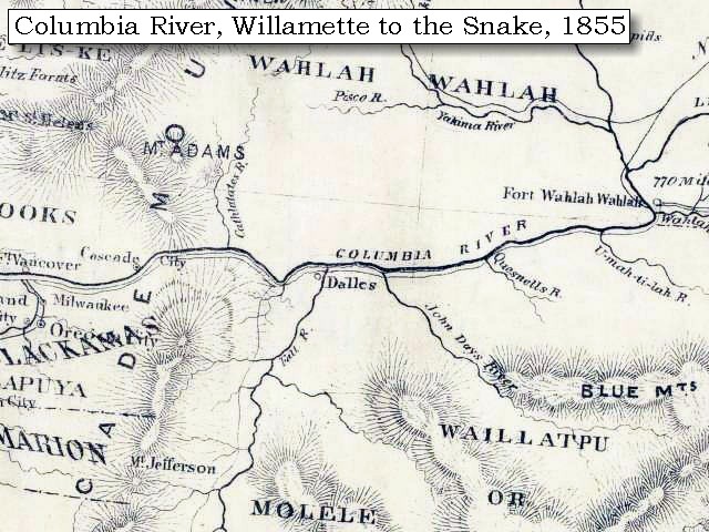
Junction of the Snake River with the Columbia River: The Snake River joins the Columbia River at River Mile 325, near Pasco, Washington. Lewis and Clark spent two nights camped at the junction, a spot known today as Sacajawea State Park. 


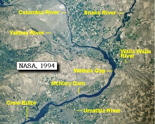
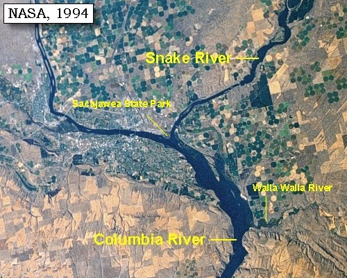
Columbia River: The Columbia River and its tributaries form the dominant water system in the Pacific Northwest. The mainstem of the Columbia rises in Columbia Lake in British Columbia, Canada. After flowing a path for 1,270 miles, the Columbia joins the Pacific Ocean near Astoria, Oregon. The major tributaries of the Columbia are the Kootenai, Flathead/Pend Oreille/Clark's Fork, Snake, and Willamette. The largest of these tributaries, the Snake, travels 1,038 miles from its source in Yellowstone National Park in Wyoming. The Snake River enters the Columbia at Columbia River Mile 325, near Pasco, Washington. On May 12, 1792, the American Captain Robert Gray, became the first explorer to enter the Columbia River by crossing over the sandbar that blocked its mouth. Gray sailed about 20 miles up the estuary of the river, traded with the Indians for a few days, and then left after drawing a chart of the mouth of the river. He named the river the Columbia after his ship, and claimed it for the United States. British Captain George Vancouver obtained a copy of Gray's chart from the Spanish governor at Nootka Sound and sailed to the mouth of the Columbia River in October 1792. He was unable to get his flagship Discovery over the sandbar, but Lt. William Robert Broughton succeeded with his smaller ship, the Chatham. Broughton advanced nearly 100 miles to a site opposite present-day Portland, Oregon, which he named Point Vancouver. To the east he saw a majestic mountain peak which he named Mount Hood. -- U.S. Army Corps of Engineers, 2002, and University of Virginia Library Special Collections Website, 2002 

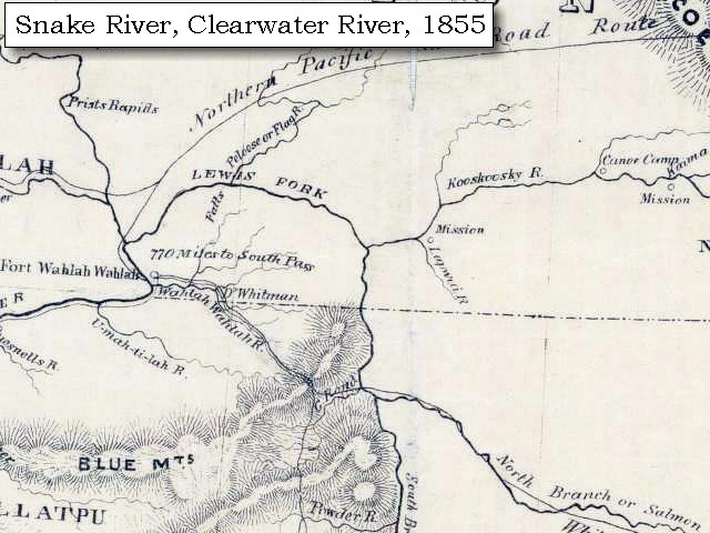
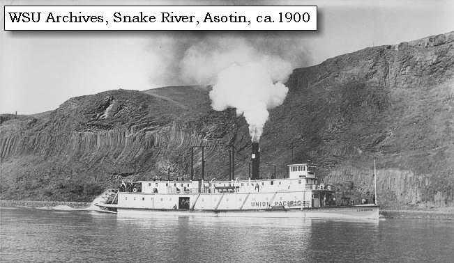
Snake River: The Snake River originates in Yellowstone National Park at 9,500 feet and winds through southern Idaho before turning north to form the boundary between Idaho and Oregon. It finally joins the Columbia River at Mile 325 near Pasco, Washington, 1,036 miles from its source. Elevation at the confluence is 340 feet. How did it get its name? To identify themselves, Indians living along the river in southern Idaho used a hand sign that resembled the movement of a snake. Although it didn't mean "Snake", that name was given to this group of people, now known as Shoshone. The river flowing through the Snake Indian lands was given the tribal name. -- U.S. National Park Service, Wild and Scenic Rivers Website, 2002, and Idaho State Parks and Recreation Website, 2002 
|
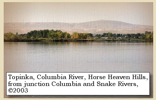
| From the point of junction the country is a continued plain, which is low near the water, from which it rises gradually, and the only elevation to be seen is a range of high country [Horse Heaven Hills] running from the northeast towards the southwest, |
|
|
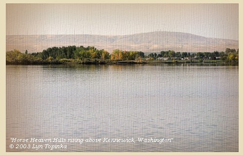
Horse Heaven Hills: Like all the ridges that surround the Tri-Cities and lower Columbia Basin (Richland, Pasco, and Kennewick), the geology of the Horse Heaven Hills is a story of lava eruptions followed by buckling of the lava flows as they were squeezed from the north and south. The Columbia Plateau province is dominated by lavas of the Columbia River Basalt Group (CRBG), which include the Grande Ronde, Wanapum, and Saddle Mountains Basalts. The basalt occurs as multiple flows, each ranging in thickness from 10 to over 100 feet. After the lavas hardened into rock, earth forces, which still operate today, compressed the region from the north and south. The rock responded by buckling into a series of ridges that trend mainly east-west. Rattlesnake Mountain, Badger Mountain, Red Mountain and the Horse Heaven Hills are some of the more familiar names of these ridges. Rattlesnake Mountain and the Horse Heaven Hills are higher than most of the ridges around here but when you take a close look at any of these ridges, the higher elevations typically are on the north side. The north side is highest because its the point where the rocks change from a north facing slope to a south facing slope. -- Morace, et.al., 1998, Steve Reidel, Pacific Northwest National Laboratory, and Swanson and Wright, 1981
|
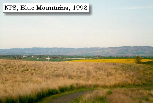
| where it joins a range of mountains [Blue Mountains] from the southwest, and is on the opposite side about two miles from the Columbia. There is through this plain no tree and scarcely any shrub, except a few willow bushes; and even of smaller plants there is not much more than the prickly pear, which is in great abundance, and is even more thorny and troublesome than any we have yet seen. ...... |
|
|
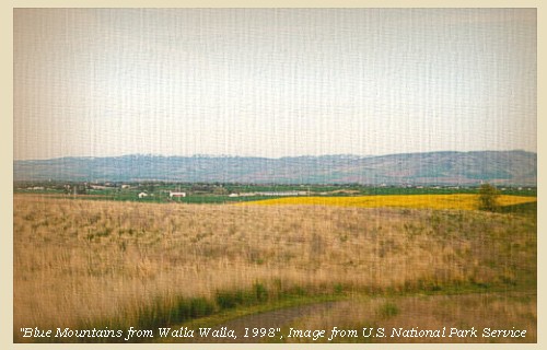
Blue Mountains: The topography of the Blue Mountains consists of flat-topped ridges and steep stair-stepped valley walls formed by thousands of feet of Miocene basalt flows that engulfed the folded, faulted, and uplifted granitic core of the mountains. As mountains were uplifted, streams and glaciers carved canyons through the basalt layers. -- Columbia Basin Fish and Wildlife Authority Website, 2004
|
| The nation among which we now are call themselves Sokulks; and with them are united a few of another nation, who reside on a western branch [Yakima River], emptying itself into the Columbia a few miles above the mouth of the latter river, and whose name is Chimnapum. ...... |
| "... there is no timber of any sort except Small willow bushes in sight in any direction. from this Island the natives showed me the enterance of a large Westerly fork which they Call Tapetett at about 8 miles distant ... " [Clark, October 17, 1805] |
|
|
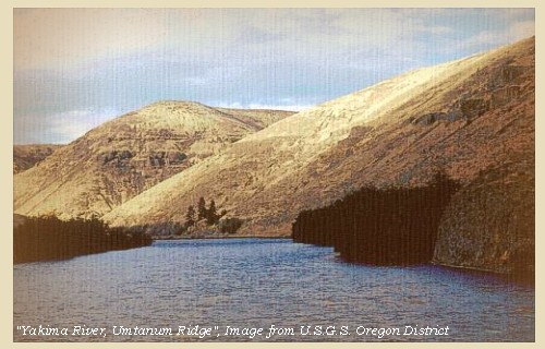
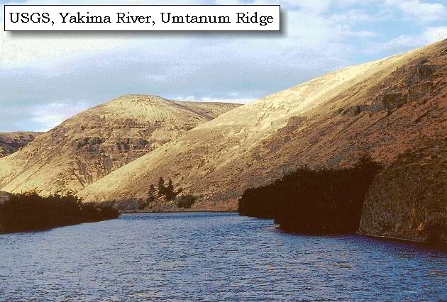
Yakima River: The Yakima River flows 215 miles from the outlet of Keechelus Lake in the central Washington Cascades southeasterly to the Columbia River, draining an area of 6,155 square miles. Altitude in the basin ranges from 340 feet at the mouth of the Yakima River to 8,184 feet near the headwaters. The Yakima River Basin comprises parts of the Columbia Plateau and the Cascade geologic provinces. About two-thirds of the basin, including the entire southern and eastern parts, is in the Columbia Plateau, a province that consists primarily of basalt flows with minor interbedded and overlying sediment. The western and northern margins of the basin are in the Cascade Range. -- USGS Water Resources of Oregon Website, 2002, and Morace, et.al., 1998 
|
| Side-Trip Up the Columbia River |
| Thursday, October 17, 1805 ... Continued |
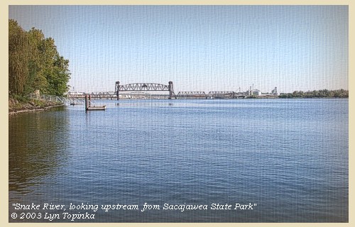
| In the course of the day captain Clarke, in a small canoe with two men, ascended the Columbia. At the distance of five miles he passed an island [Clover Island] in the middle of the river, at the head of which is a small and not a dangerous rapid. ...... |
|
|
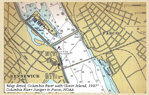
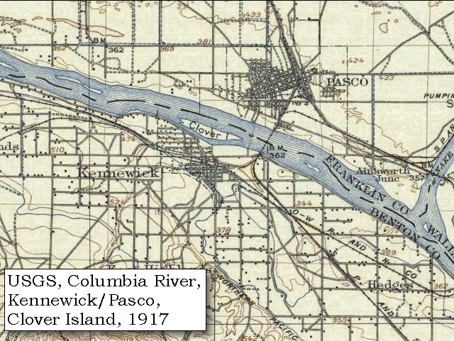
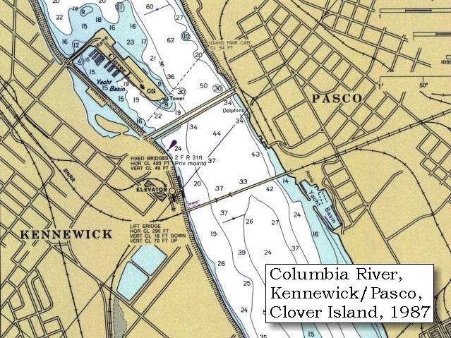
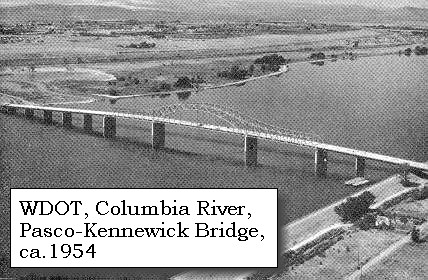
Clover Island and the Pasco-Kennewick Bridges: Clover Island is bordered on both sides by bridges linking Pasco and Kennewick. The first bridge was completed in 1922 is downstream of Clover Island, and since 1990 has been on the National Register of Historical Places (#82004213). This bridge has since been destroyed and replaced by the Pasco-Kennewich "Cable" Bridge. The second bridge, the "Blue" Bridge, was built upstream of Clover Island, and completed in the 1950s. Also called the "Pioneer Memorial Bridge", it was added to the National Register of Historical Places (#02000241) in 2002. -- National Register of Historical Places Website, 2004, 2005, and Washington State Department of Transportation Website, 2003
|
| At the distance of four miles from the last island, came to the lower point of another near the left shore where he halted at two large mat houses [Bateman Island]. ...... |
| "... I took two men in a Small Canoe and assended the Columbia river 10 miles to an Island near the Stard. Shore on which two large Mat Lodges of Indians were drying Salmon ..." [Clark, October 17, 1805] |
|
|
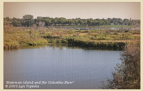
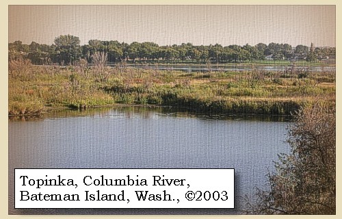
Bateman Island: Called "Riverview Island" in 1917 (see map), Bateman Island is located on the Columbia River between the cities of Richland and Kennewick, Washington. This remarkable island is classified as an urban wildlife viewing area, and has Department of Transportation highway signs use "binocular icons" to identify the area. The island is accessible via a small land-bridge and hard-packed, single-track trails make it easy to hike or mountain-bike the entire island. The island is a riparian habitat that is home to many species of migratory waterfowl, as well as native animal life. Bateman Island marks the furthest point up-river on the Columbia ever explored by the Lewis & Clark expedition. However, as a protected area, collecting, digging or exploring for American Indian artifacts is not allowed. -- Tri-Cities Visitor and Convention Bureau Website, 2002 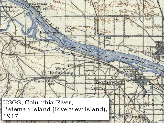
|
| From this island they showed him the entrance of a western branch of the Columbia, called the 'Tapteal' [Yakima River], which as far as could be seen bears nearly west, and empties itself about eight miles above into the Columbia; the general course of which is northwest: towards the southwest a range of highland [Horse Heaven Hills] runs parallel to the river, at the distance of two miles on the left, while on the right side the country is low and covered with the prickly pear, and a weed or plant two or three feet high resembling whins. To the eastward is a range of mountains [Blue Mountains] about fifty or sixty miles distant, which bear north and south; but neither in the low grounds, nor in the highlands is any timber to be seen. |
| "... from this Island the natives showed me the enterance of a large Westerly fork which they Call Tapetett at about 8 miles distant, the evening being late I deturmined to return to the forks, at which place I reached at Dark. from the point up the Columbia river is N. 83o W. 6 miles to the lower point of an Island near the Lard. Side passed a Island in the middle of the river at 5 miles at the head of which is a rapid, not dangerous on the Lard Side opposit to this rapid is a fishing place ... The Waters of this river is Clear, and a Salmon may be Seen at the deabth of 15 or 20 feet. ..." [Clark, October 17, 1805, early on in narrative, final draft] |
| "... from those Lodges the natives Showed me the mouth of 'Tap teel' River about 8 miles above on the west Side this western fork appears to beare nearly West, The main Columbia river N W. -- a range of high land to the S W and parralal to the river and at the distance of 2 miles on the Lard. Side, the countrey low on the Stard. Side, and all Coverd. with a weed or plant about 2 & three feet high and resembles the whins. I can proceive a range of mountains to the East which appears to bare N. & South distant about 50 or 60 miles. no wood to be Seen in any derection ..." [Clark, October 17, 1805, later in narrative, final draft] |
| The evening coming on he determined not to proceed further than the island and therefore returned to camp [Sacajawea State Park, confluence of the Snake River with the Columbia]. ...... |
|
|
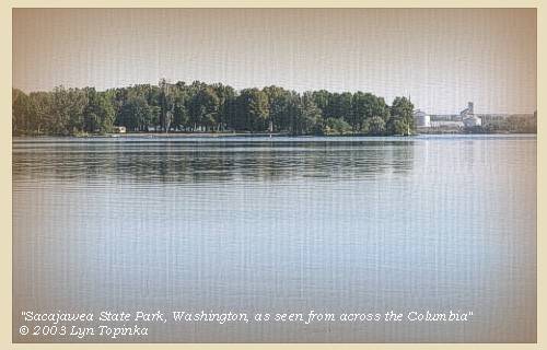
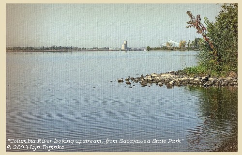
Sacajawea State Park: Sacajawea State Park is a 284-acre marine, day-use park at the confluence of the Snake and Columbia rivers. It features 9,100 feet of freshwater shoreline. The area is spread out with a big sky and excellent views of the two rivers as they flow together. The park's lands are sand dunes interspersed with wetland ponds. The park is on the plain of the great Lake Missoula floods, which swept through the area 12,000 years ago. The property was deeded to Washington State Parks in 1931. The park is named for Sacajawea, a Shoshoni Indian woman who traveled with the Lewis and Clark expedition. The park is located on one of the expedition's campsites, used by Lewis and Clark from October 16 to 18, 1805. -- Washington State Parks and Recreation Website, 2002

|
|
|
|
The Camp - October 16 and 17, 1805:
Lewis and Clark's camp of October 16 and 17, 1805, was at the confluence of the Snake and Columbia Rivers at what is now known as Sacajawea State Park just outside Pasco, Washington, on U.S. Route 12 heading towards Walla Walla. The original campsite is now under the waters of Lake Wallula, behind McNary Dam. |
| Home | Previous | Continue |
If you have questions or comments please contact: GS-CVO-WEB@usgs.gov
June/July 2004, Lyn Topinka
The Volcanoes of Lewis and Clark Home Page | CVO Home Page