The Volcanoes of
Lewis and Clark
October 25, 1805
The Dalles - "Long Narrows"
 
Home
The Volcanoes of Lewis and Clark

Map of the Journey
Volcanoes, Basalt Plateaus, Major Rivers, etc.

The Volcanoes
Mount Adams, Mount Hood, Mount Jefferson, Mount Rainier, and Mount St. Helens

CALENDAR of the Journey
October 1805 to June 1806

Along the Journey
Pacific Northwest Maps - Columbia River, Volcanoes, Flood Basalts, Missoula Floods, Geology, etc.

The Corps of Discovery
The Journey of Lewis and Clark

About the Reference Materials
The Journals, Biddle/Allen, DeVoto, Gass, Moulton, Topo Maps, and others

USGS Lewis and Clark Links
Links to USGS Websites highlighting the Lewis and Clark Journey

Resources
Publications Referenced and Websites Visited


PREVIOUS

October 24
"Short Narrows"
October 25

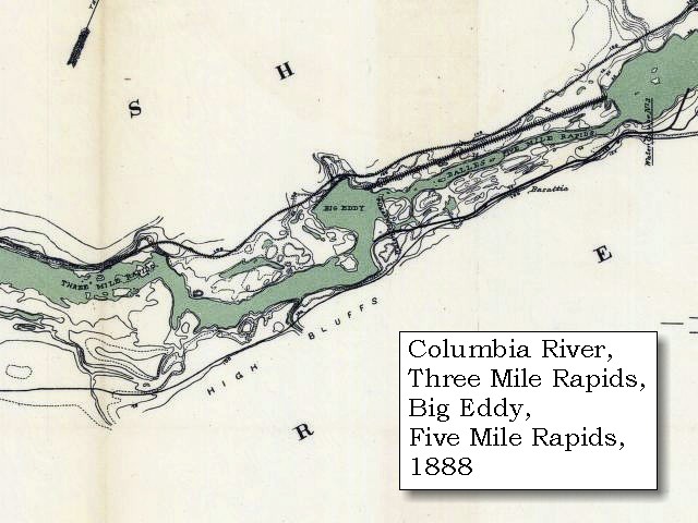
The Dalles,
"Long Narrows"

Horsethief Butte, Five-Mile Rapids ("Long Narrows"), Spearfish Lake Park and "Big Eddy", The Dalles Dam, The Dalles (Oregon), Mill Creek, Rock Fort and Mount Hood
CONTINUE

October 26-28
The Dalles, "Long Narrows"
 

On October 7, 1805, Lewis and Clark and the "Corps of Discovery" began their journey down the Clearwater River and into the volcanics of the Pacific Northwest. The Corps travelled from the Clearwater to the Snake and down the "Great Columbia", finally reaching the Pacific Ocean on November 15, 1805. Along the journey they encountered the lava flows of the Columbia Plateau, river channels carved by the great "Missoula Floods", and the awesome beauty of five Cascade Range volcanoes.

Map, Lewis and Clark in the Pacific Northwest, click for brief
                         summary
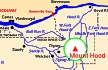
[Click map for brief summary about the area]


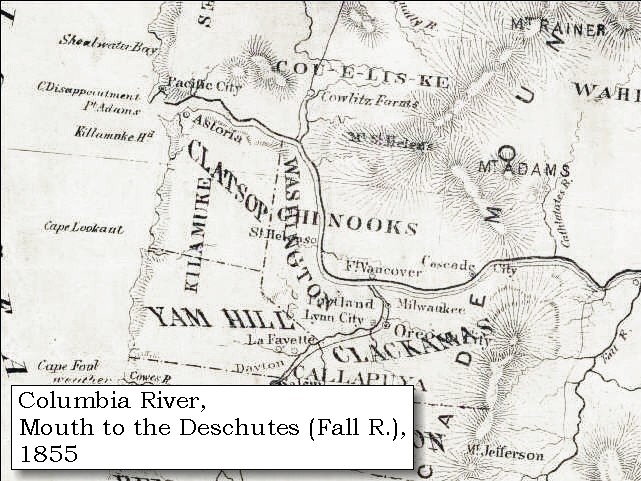
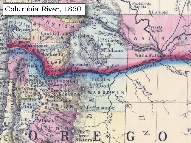
To the Pacific - October 1805
The Dalles - "Long Narrows"
 

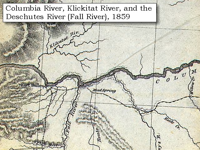
Lewis and Clark's camp of October 24, 1805, was on the Washington State side of the Columbia River, near the location of today's Horsethief Lake State Park, just upstream of the "Long Narrows", and downstream from the "Short Narrows".

Friday, October 25, 1805
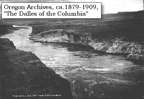
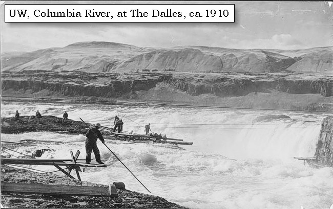
We walked down with several of the Indians to view the part of the narrows [Five Mile Rapids ("The Long Narrows")] which they represented as most dangerous: we found it very difficult, but, as with our large canoes the portage was impracticable, we concluded on carrying our most valuable articles by land, and then hazarding the passage. We therefore returned to the village, and after sending some of the party with our best stores to make a portage, and fixed others on the rock to assist with ropes the canoes that might meet with any difficulty, we began the descent, in the presence of great numbers of Indians who had collected to witness this exploit. The channel for three miles is worn through a hard rough black rock from fifty to one hundred yards wide. in which the water swells and boils in a tremendous manner.


Along the Journey - October 25, 1805
Geology of Horsethief Butte and Vicinity:
Horsethief Butte and the surrounding Columbia River channel were carved out of basalt rock by floods following the last ice age. The basalt rock resulted from a series of lava flows which emerged from cracks in the earth's crust and blanketed the entire eastern Washington/Oregon region long before the coming of ice-age floods. When viewing the cliffs along the river, notice the stratigraphy highlighted by benches rising up the cliffs. Each of these benches, or layers, represents a different lava flow. Some lava flows were hundreds of feet thick in places. -- Washington State Parks and Recreation Website, 2002


The three first canoes escaped very well; the fourth, however, had nearly filled with water; the fifth passed through with only a small quantity of water over her. At half a mile we had got through the worst part, and having reloaded our canoes went on very well for two and a half miles, except that one of the boats was nearly lost by running against a rock.


Along the Journey - October 25, 1805
Fishing at The Dalles, ca.1910

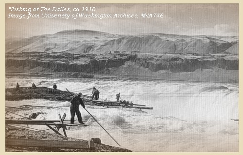
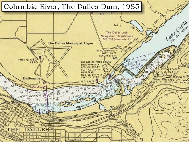
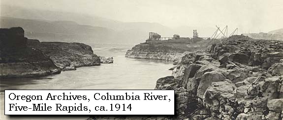
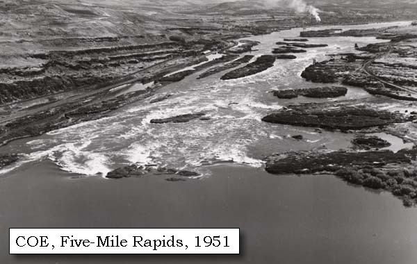
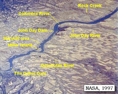
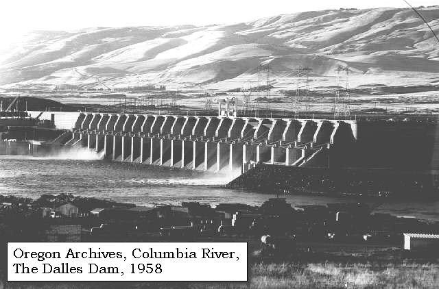
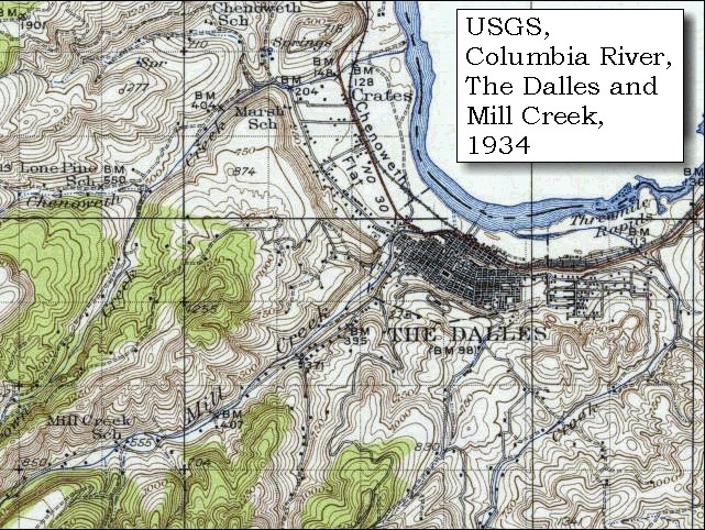
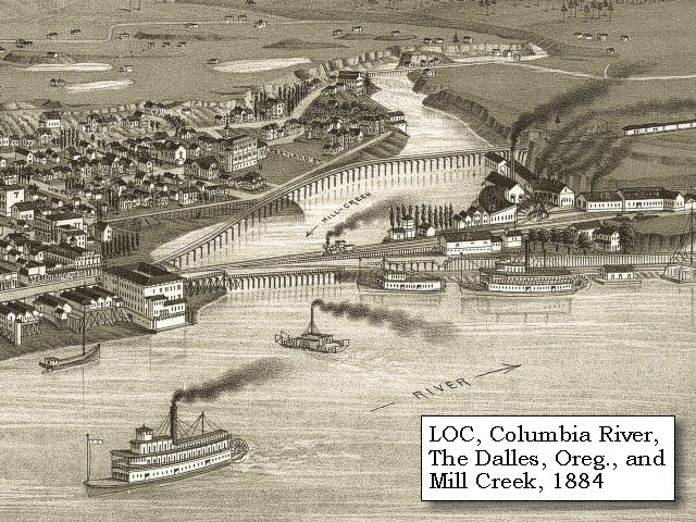
Five-Mile Rapids ("Long Narrows" or "The Dalles"):
Five-Mile Rapids was also known as the "Long Narrows", "The Dalles", and "The Great Dalles". During the steamboad era on the Columbia River, rapids in this vicinity were called names representing their distance east from the boat landing at the Dalles. The Five-Mile Rapids area was under consideration as a dam site about 1914. Decades later The Dalles Dam was constructed downstream. Excavations in this area show humans have occupied this ideal salmon fishing site for more than 10,000 years. -- Washington State Historical Society Website, 2002, "Lasting Legacy", Washington State Lewis and Clark Heritage Website, 2002, Oregon State Archives Website, 2002, and U.S. Forest Service Website, 2002, The Columbia River Gorge


Map, 1854, Columbia River, Hood River to the John Day, click to enlarge Map, 1858 Military recon map, The Dalles vicinity, click to enlarge Map, 1887, The Dalles vicinity, click to enlarge Map, 1888, Five Mile Rapids, click to enlarge Map, 1934 USGS topo map upstream of The Dalles, click to enlarge Map, 1946, The Dalles, Three-Mile Rapids, Big Eddy, Five-Mile Rapids, click to enlarge Map, 1985, The Dalles, The Dalles Dam, Three-Mile Rapids, Big Eddy, Five-Mile Rapids, click to enlarge Image, ca.1879-1909, The Dalles, click to enlarge Image, ca.1910, The Dalles, click to enlarge Image, ca.1914, Five-Mile Rapids, click to enlarge Image, 1951, Five-Mile Rapids, click to enlarge
  1. 1853-54 Map, Columbia River, including the Hood River to John Day area (section of original). (Click to enlarge). Includes Hood River (Dog River), Klickitat River (Klikatat R.), Mill Creek (?) (Wasco Ck.), The Dalles, The Deschutes (Wanwauwie or des Chutes R.), the John Day River (Mah hah or John Day's R.), and Rock Creek (Camill Cr.). Original Map: "Rocky Mountains to Puget Sound : from explorations and surveys / made under the direction of the Hon. Jefferson Davis, Secretary of War by Isaac I. Stevens Governor of Washington Territory, 1853-4." Inset: (Supplementary sketch) Reconnaissance of the railroad route from Wallawalla to Seattle via Yak-e-mah River & Snoqualmie Pass. By A. W. Tinkham in January 1854. Drawn by J. R. P. Mechlin. 20 x 28 cm. Topographer, John Lambert, Published in Washington D.C., 1859, 1:1,200,000, Notes: From the U.S. War Department, Explorations and Surveys for a Railroad Route from the Mississippi River to the Pacific Ocean, Topographical Maps, to Illustrate the Various Reports, U.S. Library of Congress American Memories Reference "LC Railroad Maps #156". -- U.S. Library of Congress, American Memories Website, 2004
  2. 1858 Military Recon Map (section of original), Columbia River and The Dalles Vicinity. (Click to enlarge). Map of military reconnaissance from Fort Dalles, Oregon, via Fort Wallah-Wallah, to Fort Taylor, Washington Territory, 1858. Shows approximate location of military road constructed 1859 to 1862. From the report and maps of Captain John Mullan, United States Army, G.P.O., 1863. University of Washington Archives #UW85. -- University of Washington Library Archives Website, 2002
  3. 1887 Map (section of original), Columbia River at The Dalles. (Click to enlarge). Original Map: The Columbia River from Celilo to the mouth showing locations of the salmon fisheries, 1887. Scale ca. 1:375,000, Relief shown by hachures. U.S. Army Corps of Engineers, Engineer Office, G.P.O. 1888. University of Washington Archives #UW128. -- University of Washington Library Archives Website, 2002
  4. 1888 Map (section of original), Columbia River at Three Mile Rapids, the Big Eddy, and Five Mile Rapids. (Click to enlarge). Original Map: Map of Columbia River from The Dalles to Celilo, Oregon, 1880. Scale 1:30,000. Relief shown by contours. Shows a section of the Columbia River, including fall and rapids, water gauges, and "basaltic" region. Original map is reduced from sheet 1 and 2, survey of 1879-1880, Published G.P.O. 1889. University of Washington Archives #UW66. -- University of Washington Library Archives Website, 2002
  5. 1934 Map (section of original), from The Dalles 1:125,000 topographic quadrangle. (Click to enlarge). The Columbia River upsteam of The Dalles, Oregon (the Washington side is not depicted on this map), including Three Mile Rapids, Big Eddy, and Five Mile Rapids. Original map surveyed in 1929-30, contour interval of 50 feet. -- University of Washington Library Collections Website, 2002
  6. 1946 Map (section of original), Columbia River with The Dalles, Three-Mile Rapids, Big Eddy, Five-Mile Rapids. (Click to enlarge). Office of Coast Surveys, Historical Maps and Charts, Columbia River, Bonneville to The Dalles, 1946, Chart#6157, 1:40,000. -- NOAA Office of Coast Survey Website, 2004
  7. 1985 Map (section of original), Columbia River with The Dalles, The Dalles Dam, Three-Mile Rapids, Big Eddy, Five-Mile Rapids. (Click to enlarge). Office of Coast Surveys, Historical Maps and Charts, Columbia River, Bonneville to The Dalles, 1985, Chart#18531, 1:40,000. -- NOAA Office of Coast Survey Website, 2004
  8. ca.1879-1909, "The Dalles" (Click to enlarge). A scene in the region served by the Oregon Railway & Navigation Company between 1879-1909. Oregon State Archives Photograph, Photograph Date: 1879-1909, From: Salem Public Library Collection. -- Oregon State Archives Website, 2002
  9. ca.1910, Columbia River area Indians fishing with spears from platforms at The Dalles, Oregon, ca.1910. (Click to enlarge). University of Washington Archives Photograph #NA746, General Indian Collection no.564. Photograph Date: ca.1910. From: University of Washington Libraries, Seattle, Washington -- University of Washington Libraries and the Library of Congress, American Memories Website, 2002
  10. ca.1914, Columbia River at Five-Mile Rapids. (Click to enlarge). Water Resources Department Records, Photographs and Negatives, 93A-011. -- Oregon State Archives Website, 2002
  11. 1951, Aerial view, Columbia River at Five-Mile Rapids. (Click to enlarge). U.S. Army Corps of Engineers Photo, April 10, 1951, Five-Mile Rapids and Celilo Falls, Oregon. At center right are No.5 and No.6 fishwheels. Columbia Gorge Discovery Center Archives #1999.04.50b. -- Columbia Gorge Discovery Center Website, 2004.


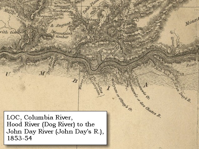
At the end of this channel of three miles, in which the Indians inform us they catch as many salmon as they wish, we reached a deep basin or bend of the river towards the right [Big Eddy], near the entrance of which are two rocks.


Along the Journey - October 25, 1805
Spearfish Lake Park (

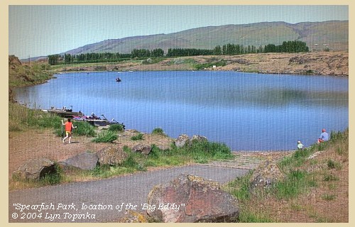
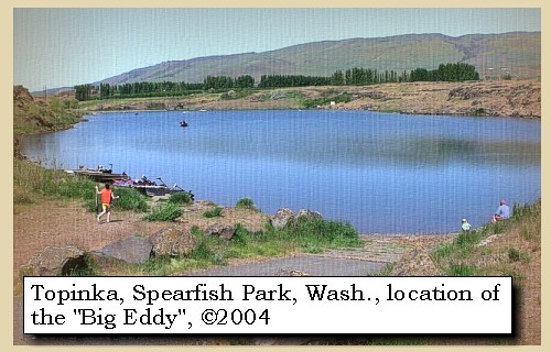
Spearfish Lake Park and the "Big Eddy":
The "Big Eddy" was at the foot of the "Five-Mile Rapids", also known as the "Long Narrows". Today, the "Long Narrows" is under the waters of Lake Celilo, the reservoir behind The Dalles Dam. Spearfish Lake Park is a U.S. Army Corps of Engineers day-use park near the location of the "Big Eddy".


Map, 1888, Five Mile Rapids, click to enlarge Map, 1934 USGS topo map upstream of The Dalles, click to enlarge Map, 1946, The Dalles, Three-Mile Rapids, Big Eddy, Five-Mile Rapids, click to enlarge Map, 1985, The Dalles, The Dalles Dam, Three-Mile Rapids, Big Eddy, Five-Mile Rapids, click to enlarge Image, ca.1925, Mount Hood, The Dalles, from Big Eddy, click to enlarge Image, 2004, Spearfish Lake Park, location of the Big Eddy
  1. 1888 Map (section of original), Columbia River at Three Mile Rapids, the Big Eddy, and Five Mile Rapids. (Click to enlarge). Original Map: Map of Columbia River from The Dalles to Celilo, Oregon, 1880. Scale 1:30,000. Relief shown by contours. Shows a section of the Columbia River, including fall and rapids, water gauges, and "basaltic" region. Original map is reduced from sheet 1 and 2, survey of 1879-1880, Published G.P.O. 1889. University of Washington Archives #UW66. -- University of Washington Library Archives Website, 2002
  2. 1934 Map (section of original), from The Dalles 1:125,000 topographic quadrangle. (Click to enlarge). The Columbia River upsteam of The Dalles, Oregon (the Washington side is not depicted on this map), including Three Mile Rapids, Big Eddy, and Five Mile Rapids. Original map surveyed in 1929-30, contour interval of 50 feet. -- University of Washington Library Collections Website, 2002
  3. 1946 Map (section of original), Columbia River with The Dalles, Three-Mile Rapids, Big Eddy, Five-Mile Rapids. (Click to enlarge). Office of Coast Surveys, Historical Maps and Charts, Columbia River, Bonneville to The Dalles, 1946, Chart#6157, 1:40,000. -- NOAA Office of Coast Survey Website, 2004
  4. 1985 Map (section of original), Columbia River with The Dalles, The Dalles Dam, Three-Mile Rapids, Big Eddy, Five-Mile Rapids. (Click to enlarge). Office of Coast Surveys, Historical Maps and Charts, Columbia River, Bonneville to The Dalles, 1985, Chart#18531, 1:40,000. -- NOAA Office of Coast Survey Website, 2004
  5. ca.1925, Mount Hood and The Dalles, Oregon, from Big Eddy. (Click to enlarge). Oregon Historical Society OrHi#100051, Photographer Benjamin C. Markham, approximate Photograph Date: 1925, Columbia Gorge Discovery Center Catalogue #2001.06.006. -- Image from Columbia Gorge Discovery Center Website, 2004, and additional information from U.S. Library of Congress Website, 2004.
  6. 2004, Spearfish Lake Park, at the location of the "Big Eddy". (Click to enlarge). Copyright © 2004 Lyn Topinka, private archives, used with permission.


We crossed the basin [Big Eddy], which has a quiet and gentle current, and at the distance of a mile from its commencement, and a little below where the river resumes its channel, reached a rock which divides it. At this place we met our old chiefs, who, when we began the portage, had walked down to a village below to smoke a pipe of friendship on the renewal of peace. ...... On leaving this rock the river is gentle, but strewed with a great number of rocks for a few miles [Three-Mile Rapids, now the location of The Dalles Dam]


Along the Journey - October 25, 1805
The Dalles Dam

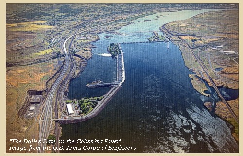
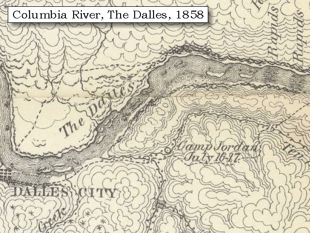
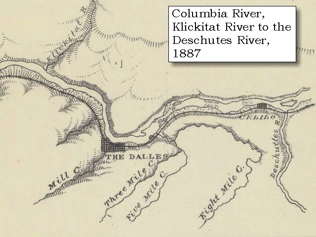
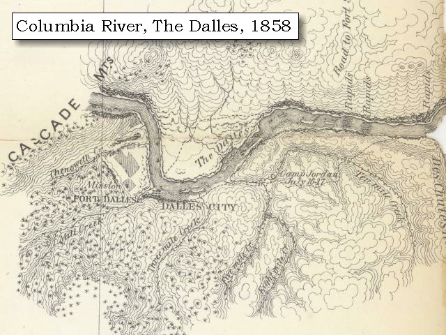
The Dalles Dam:
The Dalles Dam is located 192 miles upstream from the mouth of the Columbia River, two miles east of the city of The Dalles, Oregon. The dam extends 1.5 miles from the Oregon shore to the navigation lock on the Washington shore. Because the boundary between the two states follows the old river channel, The Dalles Dam is almost entirely in the state of Washington. The project consists of a navigation lock, spillway, powerhouse and fish passage facilities. Various recreational facilities are provided along Lake Celilo, the 24-mile-long impoundment behind the dam. -- U.S. Corps of Engineers Website, 2002


Map, 1888, Five Mile Rapids, click to enlarge Map, 1934 USGS topo map upstream of The Dalles, click to enlarge Map, 1934 USGS topo map of The Dalles Mill Creek area, click to enlarge Map, 1946, The Dalles, Three-Mile Rapids, Big Eddy, Five-Mile Rapids, click to enlarge Map, 1985, The Dalles, The Dalles Dam, Three-Mile Rapids, Big Eddy, Five-Mile Rapids, click to enlarge NASA Image, 1997, Columbia River from The Dalles to Rock Creek, click to enlarge Image, 1958, The Dalles Vicinity, Oregon, click to enlarge Image, The Dalles Dam, Oregon, click to enlarge
  1. 1888 Map (section of original), Columbia River at Three Mile Rapids, the Big Eddy, and Five Mile Rapids. (Click to enlarge). Original Map: Map of Columbia River from The Dalles to Celilo, Oregon, 1880. Scale 1:30,000. Relief shown by contours. Shows a section of the Columbia River, including fall and rapids, water gauges, and "basaltic" region. Original map is reduced from sheet 1 and 2, survey of 1879-1880, Published G.P.O. 1889. University of Washington Archives #UW66. -- University of Washington Library Archives Website, 2002
  2. 1934 Map (section of original), from The Dalles 1:125,000 topographic quadrangle. (Click to enlarge). The Columbia River upsteam of The Dalles, Oregon (the Washington side is not depicted on this map), including Three Mile Rapids, Big Eddy, and Five Mile Rapids. Original map surveyed in 1929-30, contour interval of 50 feet. -- University of Washington Library Collections Website, 2002
  3. 1934 Map, The Dalles (section of original), from The Dalles 1:125,000 topographic quadrangle. (Click to enlarge). Original map surveyed in 1929-30, contour interval of 50 feet. The Washington side of the river is not depicted on the map. -- University of Washington Library Collections Website, 2002
  4. 1946 Map (section of original), Columbia River with The Dalles, Three-Mile Rapids, Big Eddy, Five-Mile Rapids. (Click to enlarge). Office of Coast Surveys, Historical Maps and Charts, Columbia River, Bonneville to The Dalles, 1946, Chart#6157, 1:40,000. -- NOAA Office of Coast Survey Website, 2004
  5. 1985 Map (section of original), Columbia River with The Dalles, The Dalles Dam, Three-Mile Rapids, Big Eddy, Five-Mile Rapids. (Click to enlarge). Office of Coast Surveys, Historical Maps and Charts, Columbia River, Bonneville to The Dalles, 1985, Chart#18531, 1:40,000. -- NOAA Office of Coast Survey Website, 2004
  6. 1997, NASA Image, Columbia River from The Dalles to Rock Creek (Click to enlarge). View from space - northeast looking photograph of Columbia River, The Dalles Dam, John Day Dam, Miller Island, Maryhill area, Deschutes River, John Day River, and Rock Creek, 1997. The Columbia River flows upper right (east) to lower left (west). NASA Earth from Space #STS085-734-085. -- NASA Earth from Space Website, 2002
  7. 1958, All the rapids of the Columbia River were inundated in March 1957 when The Dalles Dam was completed, forming Lake Celilo. (Click to enlarge). Oregon State Archives Photograph #7246(Ben Maxwell). Photograph Date: September 15, 1958. Photographer: Ben Maxwell. From: Salem Public Library Collection. -- Oregon State Archives Website, 2002
  8. Aerial view, The Dalles Dam, Oregon. (Click to enlarge). In this image, Oregon is on the left with the city of The Dalles (upper central) and Interstate-84 prominently running through the view. Washington State is on the right. -- U.S. Army Corps of Engineer Website, 2003


when it becomes a beautiful still stream about half a mile wide [location of today's city of The Dalles].


Along the Journey - October 25, 1805
Dalles City from the east, 1867

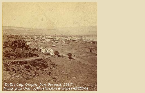
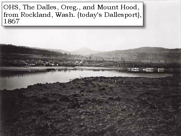
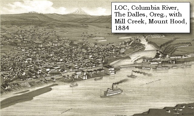
The Dalles, Oregon:
The City of The Dalles is situated in the north-central part of the Oregon on the Columbia River. It is the county seat and the largest community in Wasco County. The Dalles is one of Oregon's most historical cities. Archeological evidence suggests the area have been inhabited more or less continuously for more than 10,000 years. In the 1820s French Canadian boatmen for the British fur trading companies called the two narrow channels of the Columbia ("The Long Narrows" and the "Short Narrows") "La Grand Dalle de la Columbia" and "Les Petites Dalles." "Dalle" meant "flagstones" or "slabs" in French, for the large, smooth slabs of basalt rock that formed the channels in the river. The polished stones reminded them of stones used for paving roads and streets in eastern Canada. The Dalles was the terminus of overland travel for Oregon Trail emigrants until 1846, when the Barlow Road was opened. Camp Drum, opened in 1850 and renamed Fort Dalles in 1853, was manned by mounted riflemen until abandoned in 1867. The City of The Dalles was first incorporated by the Oregon Territorial Government in 1857 as "Dalles City" and was made the county seat shortly thereafter. Despite the official name of "Dalles City", most people, including the United States Post Office, called the town "The Dalles". In 1967 the town's name was officially changed to the "City of The Dalles," conforming to the popular custom. -- City of The Dalles Website, 2004, End of the Oregon Trail Website, 2004, and Washington State Historical Society Website, "Lasting Legacy" Website, 2004.


Map, 1853, Washington and Oregon and the Columbia River, click to enlarge Map, 1854, Columbia River, Hood River to the John Day, click to enlarge Map, 1855, Columbia River, Walla Walla to Vancouver, click to enlarge Map, 1858 Military recon map, The Dalles vicinity, click to enlarge Map, 1858 Military recon map, The Dalles vicinity, click to enlarge Map, 1859, Columbia River, Klickitat River and Fort Dalles, click to enlarge Map, 1887, The Dalles vicinity, click to enlarge Map, 1934 USGS topo map upstream of The Dalles, click to enlarge Map, 1946, The Dalles, Three-Mile Rapids, Big Eddy, Five-Mile Rapids, click to enlarge Map, 1985, The Dalles, The Dalles Dam, Three-Mile Rapids, Big Eddy, Five-Mile Rapids, click to enlarge NASA Image, 1997, Columbia River from The Dalles to Rock Creek, click to enlarge Engraving, 1853, The Dalles and Mount Hood, click to enlarge Stereo Image, 1867, The Dalles, click to enlarge Image, 1867, The Dalles, Oregon, and Mount Hood, from Rockland, Washington, click to enlarge Engraving detail, 1884, The Dalles and Mount Hood, with Mill Creek, click to enlarge Image, 2004, Mount Hood and The Dalles, Oregon
  1. 1853 Map, Washington and Oregon and the Columbia River, from the Clearwater River to the Snake River and down the Columbia River to the Pacific Ocean (section of original). (Click to enlarge). Includes: Clearwater River (Kooskooski), Lapwai Creek (Lapwai R.), Snake River (Saptin or Lewis R.), Columbia River (Columbia R.), Yakima River (Yakima R.), Walla Walla River (Wallawalla R.), Umatilla River (Umatilla R.), Willow Creek (Quesnells R.), John Day River (John day's R.), Deschutes River (Fall R.), Willamette River (Willammette R.), and Cowlitz River (Cowlitz R.). Original Map: "Map of California, Oregon, Washington, Utah, and New Mexico (1853)", by Thomas Cowperthwait & Co. Washington State University Archives #WSU22. -- Washington State University Library Collections Website, 2003
  2. 1853-54 Map, Columbia River, including the Hood River to John Day area (section of original). (Click to enlarge). Includes Hood River (Dog River), Klickitat River (Klikatat R.), Mill Creek (?) (Wasco Ck.), The Dalles, The Deschutes (Wanwauwie or des Chutes R.), the John Day River (Mah hah or John Day's R.), and Rock Creek (Camill Cr.). Original Map: "Rocky Mountains to Puget Sound : from explorations and surveys / made under the direction of the Hon. Jefferson Davis, Secretary of War by Isaac I. Stevens Governor of Washington Territory, 1853-4." Inset: (Supplementary sketch) Reconnaissance of the railroad route from Wallawalla to Seattle via Yak-e-mah River & Snoqualmie Pass. By A. W. Tinkham in January 1854. Drawn by J. R. P. Mechlin. 20 x 28 cm. Topographer, John Lambert, Published in Washington D.C., 1859, 1:1,200,000, Notes: From the U.S. War Department, Explorations and Surveys for a Railroad Route from the Mississippi River to the Pacific Ocean, Topographical Maps, to Illustrate the Various Reports, U.S. Library of Congress American Memories Reference "LC Railroad Maps #156". -- U.S. Library of Congress, American Memories Website, 2004
  3. 1855 Map, Columbia River, including The Dalles (Dalles) (section of original). (Click to enlarge). Original Map: "Map of Oregon and Washington Territories: showing the proposed Northern Railroad route to the Pacific Ocean, by John Disturnell, 1855. University of Washington Archives #UW155. -- University of Washington Library Collections Website, 2002
  4. 1858 Military Recon Map (section of original), Columbia River and The Dalles Vicinity. (Click to enlarge). Map of military reconnaissance from Fort Dalles, Oregon, via Fort Wallah-Wallah, to Fort Taylor, Washington Territory, 1858. Shows approximate location of military road constructed 1859 to 1862. From the report and maps of Captain John Mullan, United States Army, G.P.O., 1863. University of Washington Archives #UW85. -- University of Washington Library Archives Website, 2002
  5. 1858 Military Recon Map, close-in view, downstream (section of original), Columbia River and downstream The Dalles. (Click to enlarge). Map of military reconnaissance from Fort Dalles, Oregon, via Fort Wallah-Wallah, to Fort Taylor, Washington Territory, 1858. Shows approximate location of military road constructed 1859 to 1862. From the report and maps of Captain John Mullan, United States Army, G.P.O., 1863. University of Washington Archives #UW85. -- University of Washington Library Archives Website, 2002
  6. 1859 Map, Columbia River, including the Klickitat River (Klikatat Riv.), Fort Dalles, and the Deschutes River (Fall River) (section of original). (Click to enlarge). Original Map: "Map Exhibiting the Routes between Fort Dalles and the Great Salt Lake", By Bvt.2d Lieut. Joseph Dixon, Topl. Engrs. From Explorations made by him while attached to the Wagon Road Expedition to the Valley of the Great Salt Lake, under the command of Capt. H.D. Wallen, 4th Inft., Compiled under the direction of Capt. Geo. Thom, Topl. Engr., from the orders of Brig. Gen. W.S. Harney commanding the Department of Oregon, 1859. Publisher: Bureau of Topog. Engineers, 1860, UU Library ID: #G4240_1859_D5., Scale: 1:1,300,000. -- University of Utah Library, J.Willard Marriott Digitized Collections Website, 2004
  7. 1887 Map (section of original), Columbia River at The Dalles. (Click to enlarge). Original Map: The Columbia River from Celilo to the mouth showing locations of the salmon fisheries, 1887. Scale ca. 1:375,000, Relief shown by hachures. U.S. Army Corps of Engineers, Engineer Office, G.P.O. 1888. University of Washington Archives #UW128. -- University of Washington Library Archives Website, 2002
  8. 1934 Map (section of original), from The Dalles 1:125,000 topographic quadrangle. (Click to enlarge). The Columbia River at The Dalles, Oregon (the Washington side is not depicted on this map), including Three Mile Rapids, Big Eddy, and Five Mile Rapids. Original map surveyed in 1929-30, contour interval of 50 feet. -- University of Washington Library Collections Website, 2002
  9. 1946 Map (section of original), Columbia River with The Dalles, Three-Mile Rapids, Big Eddy, Five-Mile Rapids. (Click to enlarge). Office of Coast Surveys, Historical Maps and Charts, Columbia River, Bonneville to The Dalles, 1946, Chart#6157, 1:40,000. -- NOAA Office of Coast Survey Website, 2004
  10. 1985 Map (section of original), Columbia River with The Dalles, The Dalles Dam, Three-Mile Rapids, Big Eddy, Five-Mile Rapids. (Click to enlarge). Office of Coast Surveys, Historical Maps and Charts, Columbia River, Bonneville to The Dalles, 1985, Chart#18531, 1:40,000. -- NOAA Office of Coast Survey Website, 2004
  11. 1997, NASA Image, Columbia River from The Dalles to Rock Creek (Click to enlarge). View from space - northeast looking photograph of Columbia River, The Dalles Dam, John Day Dam, Miller Island, Maryhill area, Deschutes River, John Day River, and Rock Creek, 1997. The Columbia River flows upper right (east) to lower left (west). NASA Earth from Space #STS085-734-085. -- NASA Earth from Space Website, 2002
  12. 1853 Engraving, Columbia River area indian camp at The Dalles, Oregon, with Mount Hood in the background. (Click to enlarge). Engraving by John M. Stanley, 1853. From the U.S. War Department's Reports of explorations and surveys to ascertain the most practicable and econmical route for a railroad from the Mississippi River to the Pacific Ocean, 1860, v.12, pt.1, pl.43. University of Washington Libraries Collection, #NA4170. -- University of Washington Libraries Website, 2002
  13. 1867, Stereo view, The Dalles. (Click to enlarge). View from upstream. Caption on image: Dalles City, Columbia River, view from the East. Photographer: Carleton E. Watkins. Photo Date: 1867. University of Washington Stereocard Collection #STE048. -- University of Washington Libraries Collection Website, 2003
  14. 1867, The Dalles, Oregon, and Mount Hood. (Click to enlarge). View from Rockland, Washington (today's Dallesport). Photographer: Carleton Watkins. Oregon Historical Society #21577, #1100-A, Columbia Gorge Discovery Center Catalogue #2001.06.003. -- Columbia Gorge Discovery Center Website, 2004
  15. 1884, Detail from engraving of The Dalles, Oregon with Mount Hood on the skyline and the Columbia River and the mouth of Mill Creek in the foreground. (Click to enlarge). Created by H. Wellge. Published 1884, J.J. Stoner, Madison, Wisconsin. Panoramic view of the city of The Dalles, Oregon, county seat of Wasco County, 1884. Original lithograph shows The Dalles, Mount Hood, the Columbia River, and the mouth of Mill Creek. Reference #LC Panoramic Maps #727. -- Library of Congress American Memories Website, 2002
  16. 2004, Mount Hood and The Dalles, Oregon, as seen from Dallesport, Washington. (Click to enlarge). Copyright © 2004 Lyn Topinka, private archives, used with permission.


At five miles from the large bend we came to the mouth of a creek [Mill Creek] twenty yards wide, heading in the range of mountains [Cascade Mountains] which run S. S. W. and S. W. for a long distance, and discharging a considerable quantity of water: it is called by the Indians Quenett [Mill Creek].


Along the Journey - October 25, 1805
Mill Creek, 1884

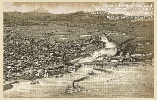
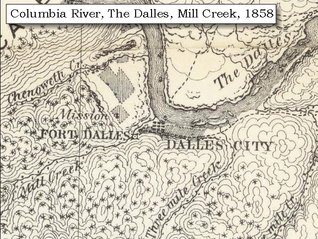
Mill Creek:
Lewis and Clark acquired the name "Que-neet Creek", (also spelled "Que-nett"), meaning "salmon trout", from the local Indians and applied it to a small stream on the southern shore of the Columbia. Seeking a defensive position for an encampment, they ascended the stream and found a natural rock formation for their security. Mill Creek, the present place name, derived from the establishment of a sawmill on the stream during the military occupation at Fort Dalles, Oregon Territory. The fort was an important military post during the Indian wars era. -- Washington State Historical Society Website, 2002, "Lasting Legacy".


Map, 1814, Lewis and Clark on the Columbia, click to enlarge Map, 1854, Columbia River, Hood River to the John Day, click to enlarge Map, 1858 Military recon map, The Dalles vicinity, click to enlarge Map, 1858 Military recon map, The Dalles and Mill Creek, click to enlarge Map, 1887, The Dalles vicinity, click to enlarge Map, 1934 USGS topo map of The Dalles Mill Creek area, click to enlarge Map, 1985, Mill Creek, The Dalles, click to enlarge Engraving detail, 1884, The Dalles and Mount Hood, with Mill Creek, click to enlarge Engraving detail, 1884, The Dalles and Mill Creek, click to enlarge Image, 1900, Trestle over Mill Creek, The Dalles, Oregon, click to enlarge
  1. 1814 Map, Lewis and Clark (section of original). (Click to enlarge.) Mill Creek is depicted but not named (left of the "To-war-na-he-ooks R.", south of the Columbia River). From the "Nicholas Biddle/Paul Allen" 1814 publication. Original Map: "A Map of Lewis and Clark's Track, Across the Western Portion of North America, From the Mississippi to the Pacific Ocean". From: History of the expedition under the command of Captains Lewis and Clark : to the sources of the Missouri, thence across the Rocky Mountains and down the river Columbia to the Pacific Ocean : performed during the years 1804-5-6 : by order of the government of the United States / prepared for the press by Paul Allen. Philadelphia : Bradford and Insskeep, 1814. Harold B. Lee Library, Brigham Young University #upbover maps37. -- Brigham Young University, Harold B. Lee Library Website, 2004.
  2. 1853-54 Map, Columbia River, including the Hood River to John Day area (section of original). (Click to enlarge). Includes Hood River (Dog River), Klickitat River (Klikatat R.), Mill Creek (?) (Wasco Ck.), The Dalles, The Deschutes (Wanwauwie or des Chutes R.), the John Day River (Mah hah or John Day's R.), and Rock Creek (Camill Cr.). Original Map: "Rocky Mountains to Puget Sound : from explorations and surveys / made under the direction of the Hon. Jefferson Davis, Secretary of War by Isaac I. Stevens Governor of Washington Territory, 1853-4." Inset: (Supplementary sketch) Reconnaissance of the railroad route from Wallawalla to Seattle via Yak-e-mah River & Snoqualmie Pass. By A. W. Tinkham in January 1854. Drawn by J. R. P. Mechlin. 20 x 28 cm. Topographer, John Lambert, Published in Washington D.C., 1859, 1:1,200,000, Notes: From the U.S. War Department, Explorations and Surveys for a Railroad Route from the Mississippi River to the Pacific Ocean, Topographical Maps, to Illustrate the Various Reports, U.S. Library of Congress American Memories Reference "LC Railroad Maps #156". -- U.S. Library of Congress, American Memories Website, 2004
  3. 1858 Military Recon Map (section of original), Columbia River and The Dalles Vicinity. (Click to enlarge). Map of military reconnaissance from Fort Dalles, Oregon, via Fort Wallah-Wallah, to Fort Taylor, Washington Territory, 1858. Shows approximate location of military road constructed 1859 to 1862. From the report and maps of Captain John Mullan, United States Army, G.P.O., 1863. University of Washington Archives #UW85. -- University of Washington Library Archives Website, 2002
  4. 1858 Military Recon Map, close-in view, downstream (section of original), Columbia River and downstream The Dalles. (Click to enlarge). Map of military reconnaissance from Fort Dalles, Oregon, via Fort Wallah-Wallah, to Fort Taylor, Washington Territory, 1858. Shows approximate location of military road constructed 1859 to 1862. From the report and maps of Captain John Mullan, United States Army, G.P.O., 1863. University of Washington Archives #UW85. -- University of Washington Library Archives Website, 2002
  5. 1887 Map (section of original), Columbia River at The Dalles, including Mill Creek. (Click to enlarge). Original Map: The Columbia River from Celilo to the mouth showing locations of the salmon fisheries, 1887. Scale ca. 1:375,000, Relief shown by hachures. U.S. Army Corps of Engineers, Engineer Office, G.P.O. 1888. University of Washington Archives #UW128. -- University of Washington Library Archives Website, 2002
  6. 1934 Map (section of original), from The Dalles 1:125,000 topographic quadrangle. (Click to enlarge). Original map surveyed in 1929-30, contour interval of 50 feet. The Washington side of the river is not depicted on the map. -- University of Washington Library Collections Website, 2002
  7. 1985 Map, Mill Creek and The Dalles. (Click to enlarge). Office of Coast Surveys, Historical Maps and Charts, Columbia River, Bonneville to The Dalles, 1985, Chart#18531, 1:40,000. -- NOAA Office of Coast Survey Website, 2004
  8. 1884, Detail from engraving of The Dalles, Oregon with Mount Hood on the skyline and the Columbia River and the mouth of Mill Creek in the foreground. (Click to enlarge). Created by H. Wellge. Published 1884, J.J. Stoner, Madison, Wisconsin. Panoramic view of the city of The Dalles, Oregon, county seat of Wasco County, 1884. Original lithograph shows The Dalles, Mount Hood, the Columbia River, and the mouth of Mill Creek. Reference #LC Panoramic Maps #727. -- Library of Congress American Memories Website, 2002
  9. 1884, Closer-in detail from engraving of The Dalles, Oregon, and the mouth of Mill Creek. (Click to enlarge). Created by H. Wellge. Published 1884, J.J. Stoner, Madison, Wisconsin. Panoramic view of the city of The Dalles, Oregon, county seat of Wasco County, 1884. Original lithograph shows The Dalles, Mount Hood, the Columbia River, and the mouth of Mill Creek. Reference #LC Panoramic Maps #727. -- Library of Congress American Memories Website, 2002
  10. 1900, Trestle over Mill Creek, The Dalles, Oregon. (Click to enlarge). Includes Umatilla House and Baldwin Opera House. Photograher: Seufert. Oregon Historical Society #38472, #1036-A, Columbia Gorge Discovery Center Catalogue #2002.13.52. -- Columbia Gorge Discovery Center Website, 2004


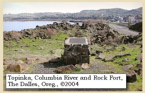
We halted below it under a high point of rocks on the left; and as it was necessary to make some celestial observations, we formed a camp on the top of these rocks [Rock Fort Camp, The Dalles, Oregon]. This situation is perfectly well calculated for defence in case the Indians should incline to attack us, for the rocks form a sort of natural fortification with the aid of the river [Columbia River] and creek [Mill Creek], and is convenient to hunt along the foot of the mountains to the west and southwest, where there are several species of timber which form fine coverts for game.
"... we proceeded on down the water fine, rocks in every derection for a fiew miles when the river widens and becoms a butifull jentle Stream of about half a mile wide, Great numbers of the Sea orter about those narrows and both below and above. we came too, under a high point of rocks on the Lard. Side below a creek of 20 yards wide and much water, as it was necessary to make Some Selestial observations we formed our camp on the top of a high point of rocks which forms a kind of fortification in the Point between the river & creek, with a boat guard ..." [Clark, October 25, 1805]


Along the Journey - October 25, 1805
Rock Fort, 2004

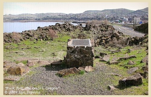
Rock Fort:
The fort-like basalt outcropping lies just downstream from the mouth of Mill Creek at present-day The Dalles, Oregon, on a wedge-shaped parcel bordered by the Columbia River, Bargeway Road, and Bridge and Garrison Streets. A riverfront trail leads to Rock Fort where interpretive signage marks the campsite. -- U.S. National Park Service Website, Lewis and Clark Expedition, 2003


Map, 1858 Military recon map, The Dalles and Mill Creek, click to enlarge Map, 1985, Mill Creek, The Dalles, click to enlarge Image, 2004, Rock Fort
  1. 1858 Military Recon Map (section of original), Columbia River and The Dalles Vicinity. (Click to enlarge). Map of military reconnaissance from Fort Dalles, Oregon, via Fort Wallah-Wallah, to Fort Taylor, Washington Territory, 1858. Shows approximate location of military road constructed 1859 to 1862. From the report and maps of Captain John Mullan, United States Army, G.P.O., 1863. University of Washington Archives #UW85. -- University of Washington Library Archives Website, 2004
  2. 1985 Map, Mill Creek and The Dalles. (Click to enlarge). Office of Coast Surveys, Historical Maps and Charts, Columbia River, Bonneville to The Dalles, 1985, Chart#18531, 1:40,000. -- NOAA Office of Coast Survey Website, 2004
  3. 2004, Rock Fort, The Dalles, Oregon. (Click to enlarge). Copyright © 2004 Lyn Topinka, private archives, used with permission.


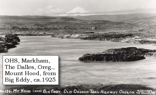
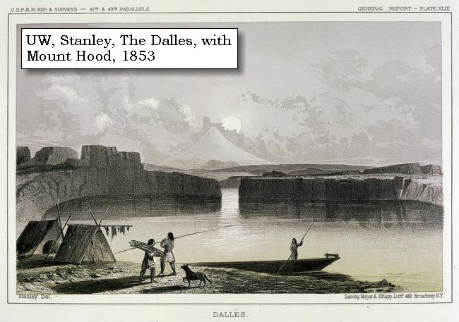
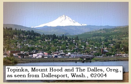
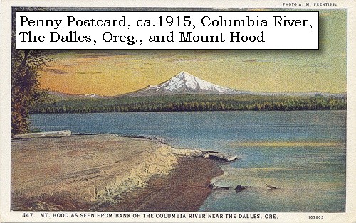
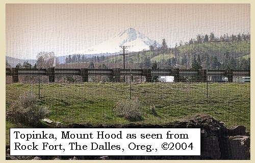
From this rock, the pinnacle of the round mountain covered with snow, which we had seen a short distance below the forks of the Columbia, and which we had called the Falls or Timm mountain [Mount Hood], is south 43? west, and about thirty-seven miles distant.
"... passed great numbers of rocks, good water and Came to at a high point of rocks below the mouth of a Creek which falls in on the Lard Side and head up towards the high Snow mountain to the S W. this Creek is 20 yards wide and has Some beaver sign at its mouth river about 1/2 mile wide and Crouded with Sea otters ..." [Clark, October 25, 1805]
"... This little Creek heads in the range of mountains which run S S W & N W for a long distance on which is Scattering pine white Oake &c. The Pinical of the round toped mountain which we Saw a Short distance below the forks of this river is S. 43o W. of us and abt 37 miles, it is at this time toped with Snow we called this the 'falls mountain' or 'Timm' mountain ..." [Clark, October 25, 1805]
"... we cn Still See the round high mountain Some distance a head yet. we Camped below the mouth of a creek on a point of rocks on the Lard. Side. the country timbered back a little from the River ..." [Ordway, October 25, 1805]


Along the Journey - October 25, 1805
Mount Hood from Rock Fort, 2004

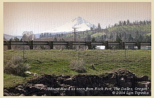
Mount Hood from Rock Fort:
Mount Hood, at 11,245 feet high, is the fourth highest peak in the Cascade Range and the highest in the state of Oregon. The peak dominates the skyline from the Portland, Oregon, metropolitan area to the wheat fields of Wasco and Sherman Counties of eastern Oregon.


Map, the Volcanoes of Lewis and Clark, click to enlarge Map, 1993, Mount Hood and Vicinity, click to enlarge Map, 1814, Lewis and Clark on the Columbia, click to enlarge Map, 1853, Washington and Oregon and the Columbia River, click to enlarge Map, 1855, Columbia River, Vancouver to the Pacific, click to enlarge Map, 1860, Columbia River, Washington, Oregon, click to enlarge Engraving, 1853, The Dalles, Oregon, with Mount Hood, click to enlarge Engraving detail, 1884, The Dalles and Mount Hood, with Mill Creek, click to enlarge Penny Postcard, ca.1915, Mount Hood from The Dalles, click to enlarge Image, 2004, Mount Hood from Rock Fort Image, 2004, Mount Hood and The Dalles, Oregon
  1. Map, "Lewis and Clark Volcano Sitings"
  2. 1993 Map, Mount Hood and Vicinity, showing river drainages which flow into the Columbia river. (Click to enlarge). Includes Hood River and the Sandy River. Map modified from: Brantley and Scott, 1993.
  3. 1814 Map, Lewis and Clark (section of original). (Click to enlarge.) Shows Mount Hood. From the "Nicholas Biddle/Paul Allen" 1814 publication. Original Map: "A Map of Lewis and Clark's Track, Across the Western Portion of North America, From the Mississippi to the Pacific Ocean". From: History of the expedition under the command of Captains Lewis and Clark : to the sources of the Missouri, thence across the Rocky Mountains and down the river Columbia to the Pacific Ocean : performed during the years 1804-5-6 : by order of the government of the United States / prepared for the press by Paul Allen. Philadelphia : Bradford and Insskeep, 1814. Harold B. Lee Library, Brigham Young University #upbover maps37. -- Brigham Young University, Harold B. Lee Library Website, 2004.
  4. 1853 Map, Washington and Oregon and the Columbia River, from the Clearwater River to the Snake River and down the Columbia River to the Pacific Ocean (section of original). (Click to enlarge). Includes: Clearwater River (Kooskooski), Lapwai Creek (Lapwai R.), Snake River (Saptin or Lewis R.), Columbia River (Columbia R.), Yakima River (Yakima R.), Walla Walla River (Wallawalla R.), Umatilla River (Umatilla R.), Willow Creek (Quesnells R.), John Day River (John day's R.), Deschutes River (Fall R.), Willamette River (Willammette R.), and Cowlitz River (Cowlitz R.). Original Map: "Map of California, Oregon, Washington, Utah, and New Mexico (1853)", by Thomas Cowperthwait & Co. Washington State University Archives #WSU22. -- Washington State University Library Collections Website, 2003
  5. 1855 Map, Columbia River from Vancouver to the Pacific, including Mount St. Helens (section of original). (Click to enlarge). Original Map: "Map of Oregon and Washington Territories: showing the proposed Northern Railroad route to the Pacific Ocean, by John Disturnell, 1855. University of Washington Archives #UW155. -- University of Washington Library Collections Website, 2002
  6. 1860 Map, Columbia River, Washington State, and Oregon (section of original). (Click to enlarge). Original Map: Map of Oregon, Washington, and British Columbia, (1860). This map dates between March 2nd, 1861 (when the Dakota Territory was formed) and March 4th, 1863 (when the Idaho Territory was formed from eastern Washington and western Dakota) Nearing retirement from a thirty year long and rather successful career, S. Augustus Mitchell printed this map showcasing Oregon, the Territory of Washington, and British Columbia. Washington became a territory in 1853, arguing that distances to Willamette Valley kept them from obtaining a voice in the Oregon territorial government. As this map shows, when it split from Oregon proper the Washington territory included parts of Wyoming and Montana and all of Idaho. Territorial government for Idaho would not be approved until 1863. When Mitchell retired he left the business for his son to manage. Washington State University Archives #WSU7. -- Washington State University Archives, 2004
  7. 1853 Engraving, Columbia River area indian camp at The Dalles, Oregon, with Mount Hood in the background. (Click to enlarge). Engraving by John M. Stanley, 1853. From the U.S. War Department's Reports of explorations and surveys to ascertain the most practicable and econmical route for a railroad from the Mississippi River to the Pacific Ocean, 1860, v.12, pt.1, pl.43. University of Washington Libraries Collection, #NA4170. -- University of Washington Libraries Website, 2002
  8. 1884, Closer-in detail from engraving of The Dalles, Oregon, and Mount Hood. (Click to enlarge). Created by H. Wellge. Published 1884, J.J. Stoner, Madison, Wisconsin. Panoramic view of the city of The Dalles, Oregon, county seat of Wasco County, 1884. Original lithograph shows The Dalles, Mount Hood, the Columbia River, and the mouth of Mill Creek. Reference #LC Panoramic Maps #727. -- Library of Congress American Memories Website, 2002
  9. ca.1915, Penny Postcard, Mount Hood from near The Dalles. (Click to enlarge). "Mount Hood as seen from bank of the Columbia River near The Dalles, Ore.", A.M. Prentiss Photo. #447, Lipschuetz of Katz, Portland, Oregon. -- L.Topinka private collection, 2003, used with permission.
  10. 2004, Mount Hood, Oregon, as seen from Rock Fort, The Dalles, Oregon. (Click to enlarge). Copyright © 2004 Lyn Topinka, private archives, used with permission.
  11. 2004, Mount Hood and The Dalles, Oregon, as seen from Dallesport, Washington. (Click to enlarge). Copyright © 2004 Lyn Topinka, private archives, used with permission.


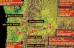
The face of the country on both sides of the river above and below the falls is steep, rugged, and rocky, with a very small proportion of herbage, and no timber, except a few bushes: the hills, however, to the west, have some scattered pine, white oak and other kinds of trees. All the timber used by the people at the upper falls is rafted down the Towahnahiooks [Deschutes River]; and those who live at the head of the narrows we have just passed, bring their wood in the same way from this creek to the lower part of the narrows, from which it is carried three miles by land to their habitations. ......
"... The face of the Countrey, on both Side of the river above and about the falls, is Steep ruged and rockey open and contain but a Small preportion of erbage, no timber a fiew bushes excepted ..." [Clark, October 25, 1805]


Along the Journey - October 25, 1805
The Camp - October 25 through October 27, 1805:
Lewis and Clark set up camp at "Rock Fort" during both their journey to the Pacific (October 25 through October 27, 1805) and their journey home (April 15 through April 17, 1806).


Home Previous Continue


If you have questions or comments please contact: GS-CVO-WEB@usgs.gov
June/July 2004, Lyn Topinka
The Volcanoes of Lewis and Clark Home Page | CVO Home Page