|
October 24, 1805 The Dalles - "Short Narrows" and "Long Narrows" |
|
Home
The Volcanoes of Lewis and Clark Map of the Journey Volcanoes, Basalt Plateaus, Major Rivers, etc. The Volcanoes Mount Adams, Mount Hood, Mount Jefferson, Mount Rainier, and Mount St. Helens CALENDAR of the Journey October 1805 to June 1806 Along the Journey Pacific Northwest Maps - Columbia River, Volcanoes, Flood Basalts, Missoula Floods, Geology, etc. The Corps of Discovery The Journey of Lewis and Clark About the Reference Materials The Journals, Biddle/Allen, DeVoto, Gass, Moulton, Topo Maps, and others USGS Lewis and Clark Links Links to USGS Websites highlighting the Lewis and Clark Journey Resources Publications Referenced and Websites Visited |
PREVIOUS
October 23 "Great Falls of the Columbia" |
October 24
The Dalles, "Short Narrows" Browns Island, Ten-Mile Rapids ("Short Narrows"), "Short Narrows and "Long Narrows", Horsethief Lake State Park, Horsethief Butte |
CONTINUE
October 25-28 The Dalles, "Long Narrows" |
On October 7, 1805, Lewis and Clark and the
"Corps of Discovery" began their journey
down the Clearwater River and into the volcanics
of the Pacific Northwest. The Corps travelled from the
Clearwater to the Snake and down the
"Great Columbia", finally reaching the
Pacific Ocean on November 15, 1805.
Along the journey they encountered the
lava flows of the Columbia Plateau,
river channels carved by the great "Missoula Floods",
and the awesome beauty of five Cascade Range volcanoes.

[Click map for brief summary about the area] |
|
To the Pacific - October 1805
The Dalles - "Short Narrows" and "Long Narrows" |
| Lewis and Clark's camp of October 22 and 23, 1805, was on the Washington side of the Columbia River, downstream of Wishram, Washington, and across from Oregon's Celilo Park, the area once known as "The Great Falls of the Columbia". |
| Thursday, October 24, 1805 |
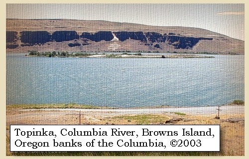
| About nine o'clock we proceeded, and on leaving our camp near the lower fall [Celilo Falls], found the river about four hundred yards wide, with a current more rapid than usual, though with no perceptible descent. At the distance of two and a half miles, the river widened into a large bend or basin on the right, at the beginning of which are three huts of Indians. At the extremity of this basin stands a high black rock, [possibly today's Browns Island] which, rising perpendicularly from the right shore, seems to run wholly across the river; so totally indeed does it appear to stop the passage, that we could not see where the water escaped, except that the current appeared to be drawn with more than usual velocity to the left of the rock, where was a great roaring. |
|
|
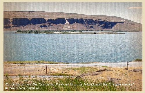
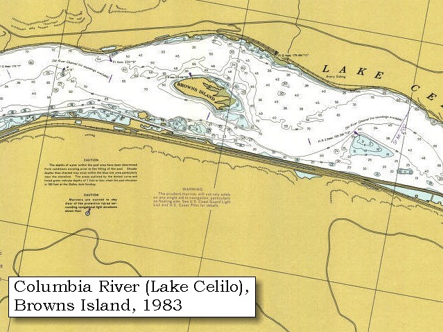
Browns Island: Comparing Lewis and Clark's maps with maps of later years, Lewis and Clark's "high black rock" quite possibly could be today's Browns Island, on the northern shore of the "Short Narrows", before the rising waters behind The Dalles Dam turned it into an island. 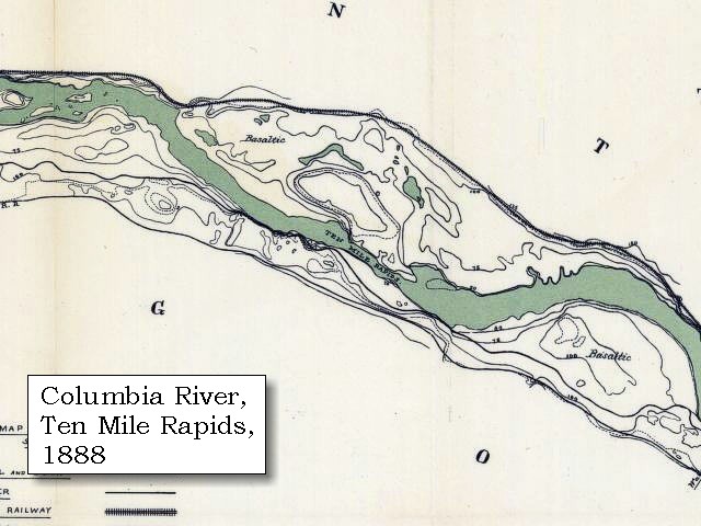
|
| We landed at the huts of the Indians, who went with us to the top of this rock [possibly today's Browns Island], from which we saw all the difficulties of the channel. We were no longer at a loss to account for the rising of the river at the falls, for this tremendous rock stretches across the river, to meet the high hills of the left shore, leaving a channel of only forty-five yards wide [the "Short Narrows", also known as "Ten-Mile Rapids"], through which the whole body of the Columbia must press its way. |
|
|
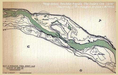
Ten-Mile Rapids ("Short Narrows"): The "Short Narrows" was also known as the "Ten Mile Rapids", the "Little Narrows", and "Les Petites Dalles". These rapids were located east of Browns Island, near Avery, Washington. -- Washington State Lewis and Clark Heritage Website, 2002 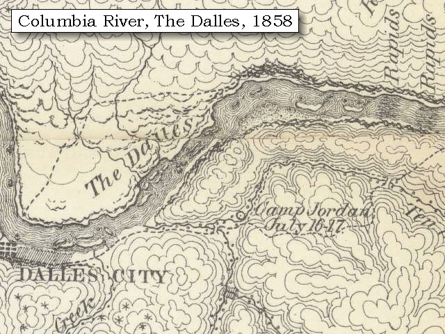
|
| The water thus forced into so narrow a channel, is thrown into whirls, and swells and boils in every part with the wildest agitation. But the alternative of carrying the boats over this high rock was almost impossible in our present situation, and as the chief danger seemed to be not from any rocks in the channel, but from the great waves and whirlpools, we resolved to try the passage in our boats, in hopes of being able by dexterous steering to escape. This we attempted, and with great care were able to get through, to the astonishment of all the Indians of the huts we had just passed, who now collected to see us from the top of the rock [possibly today's Browns Island]. |
| " ... The first pitch of this falls is 20 feet perpendecular, then passing thro' a narrow Chanel for 1 mile to rapid of about 18 feet fall below which the water has no perceptable fall but verry rapid. ... Capt. Lewis and three men crossed the river and on the opposit Side to view the falls which he had not yet taken a full view of --- At 9 oClock a.m. I Set out with the party and prceeded on down a rapid Stream of about 400 yards wide at 2 1/2 miles the river widened into a large bason to the Stard. Side on which there is five Lodges of Indians. here a tremendious black rock Presented itself high and Steep appearing to choke up the river nor could I See where the water passed further than the Current was drawn with great velocity to the Lard. Side of this rock at which place I heard a great roreing. I landed at the Lodges and the natives went with me to the top of this rock which makes from the Stard. Side; from the top of which I could See the dificuelties we had to pass for Several miles below; at this place the water of this great river is compressed into a Chanel between two rocks not exceeding 'forty five' yards wide and continues for a 1/4 of a mile when it again widens to 200 yards and continues this width for about 2 miles when it is again intersepted by rocks. This obstruction in the river accounts for the water in high floods riseing to Such a hite at the last falls. The whole of the Current of this great river must at all Stages pass thro' this narrow chanel of 45 yards wide. as the portage of our canoes over this high rock would be impossible with our Strength, and the only danger in passing thro those narrows was the whorls and Swills arriseing from the Compression of the water, and which I thought (as also our principal watermen Peter Crusat) by good Stearing we could pass down Safe, accordingly I deturmined to pass through this place notwithstanding the horrid appearance of this agitated gut Swelling, boiling & whorling in ever direction (which from the top of the rock did not appear as bad as when I was in it;) however we passed Safe to the astonishment of all the Inds: of the last Lodges who viewed us from the top of the rock. ..." [Clark, October 24, 1805] |
| The channel continues thus confined within a space of about half a mile, when the rock ceased. We passed a single Indian hut at the foot of it, where the river again enlarges itself to the width of two hundred yards, and at the distance of a mile and a half stopped to view a very bad rapid [one of the many islands along the Columbia, possibly one today called Memaloose Island, upstream of today's Horsethief Lake]; this is formed by two rocky islands which divide the channel, the lower and larger of which is in the middle of the river. |
|
|
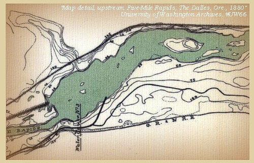
Between the "Short Narrows" and the "Long Narrows": "Short Narrows" and "Long Narrows" were names given to two locations on the Columbia River where the river constricted to form dangerous rapids. Both rapids are now under the waters of Lake Celilo, behind The Dalles Dam. During the steamboad era on the Columbia River, rapids in this vicinity were called "Three Mile Rapids" (The Dalles Dam vicinity), "Five Mile Rapids" (The Long Narrows), and "Ten Mile Rapids" (The Short Narrows), representing their distance east from the boat landing at the Dalles. French Canadian boatmen for the British fur trading companies called the two narrow channels of the river "La Grand Dalle de la Columbia" and "Les Petites Dalles." "Dalle" meant "flagstones" or "slabs" in French, for the large, smooth slabs of basalt rock that formed the channels in the river. The polished stones reminded them of stones used for paving roads and streets in eastern Canada. Other early names used by explorers and fur traders were "Columbia Falls," "Great Falls of the Columbia," "Big Chutes," and "The Narrows." -- Washington State Historical Society Website, 2002, "Lasting Legacy". 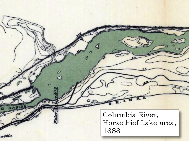

|
| The appearance of this place was so unpromising, that we unloaded all the most valuable articles; such as guns, ammunition, our papers, &c. and sent them by land with all the men that could not swim to the extremity of the rapids. We then descended with the canoes two at a time, and though the canoes took in some water, we all went through safely; after which we made two miles, and stopped in a deep bend of the river towards the right, and encamped a little above a large village of twenty-one houses [near Horsethief Lake State Park, at the head of the "Long Narrows" (Five Mile Rapids)]. Here we landed, and as it was late before all the canoes joined us, we were obliged to remain here this evening, the difficulties of the navigation having permitted us to make only six miles. |
| "... passed one Lodge below this rock and halted on the Stard. Side to view a verry bad place, the Current divided by 2 Islands of rocks the lower of them large and in the middle of the river, this place being verry bad I Sent by land all the men who could not Swim and Such articles as was most valuable to us ... and proceeded down with the Canoes two at a time to a village of 20 wood housies in a Deep bend to the Stard. Side below which a rugid black rock about 20 feet hiter than the Common high fluds of the river with Several dry Chanels which appeared to Choke the river up quite across; this I took to be the 2d falls or the place the nativs above call 'timm', ..." [Clark, October 24, 1805] |
|
|
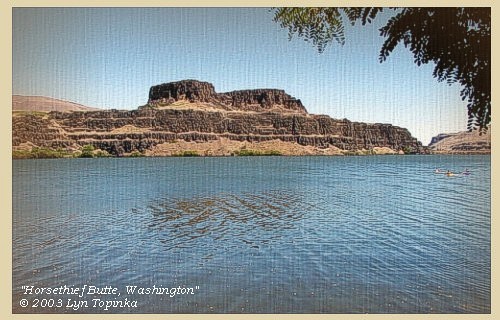
Horsethief Lake State Park: Horsethief Lake State Park is a 338-acre camping park with 7,500 feet of freshwater shoreline on the Columbia River. Horsethief Butte dominates the skyline. It stands over the lake like an ancient castle. The lake itself is about 90 acres in size and is actually an impoundment of the Columbia River. The lake was flooded into existance by the reservoir created by The Dalles Dam. For centuries, the park was the site of a Native American village. The Lewis and Clark expedition camped at the village and described its wooden houses in one of their journals. The village was flooded by the waters of The Dalles Dam. Oral history states that the park received its name from workers in the U.S. Army Corps of Engineers who developed the site. The workers thought the terrain was similar to that of horsethief hideouts in popular 1950s Hollywood westerns. The abundance of horses kept on the premises by local Indians apparently gave the workers their inspiration. -- Washington State Parks and Recreation Website, 2002

Geology of Horsethief Butte and Vicinity: Horsethief Butte and the surrounding Columbia River channel were carved out of basalt rock by floods following the last ice age. The basalt rock resulted from a series of lava flows which emerged from cracks in the earth's crust and blanketed the entire eastern Washington/Oregon region long before the coming of ice-age floods. When viewing the cliffs along the river, notice the stratigraphy highlighted by benches rising up the cliffs. Each of these benches, or layers, represents a different lava flow. Some lava flows were hundreds of feet thick in places. -- Washington State Parks and Recreation Website, 2002 |
| This village is situated at the extremity of a deep bend towards the right, and immediately above a ledge of high rocks, twenty feet above the marks of the highest flood, but broken in several places, so as to form channels which are at present dry, extending nearly across the river; this forms the second fall [Five Mile Rapids - The Long Narrows], or place most probably which the Indians indicate by the word Timm. While the canoes were coming on, captain Clarke walked with two men down to examine these channels. ...... |
|
|
|
The Camp - October 24, 1805:
Lewis and Clark's camp of October 24, 1805, was on the Washington State side of the Columbia River, near the location of today's Horsethief Lake State Park, and just upstream of the "Long Narrows". |
| Home | Previous | Continue |
If you have questions or comments please contact: GS-CVO-WEB@usgs.gov
June/July 2004, Lyn Topinka
The Volcanoes of Lewis and Clark Home Page | CVO Home Page