The Volcanoes of
Lewis and Clark
Lewis and Clark
|
October 21, 1805 Rapids and Rivers - Roosevelt and Arlington to the John Day |
|
Home
The Volcanoes of Lewis and Clark Map of the Journey Volcanoes, Basalt Plateaus, Major Rivers, etc. The Volcanoes Mount Adams, Mount Hood, Mount Jefferson, Mount Rainier, and Mount St. Helens CALENDAR of the Journey October 1805 to June 1806 Along the Journey Pacific Northwest Maps - Columbia River, Volcanoes, Flood Basalts, Missoula Floods, Geology, etc. The Corps of Discovery The Journey of Lewis and Clark About the Reference Materials The Journals, Biddle/Allen, DeVoto, Gass, Moulton, Topo Maps, and others USGS Lewis and Clark Links Links to USGS Websites highlighting the Lewis and Clark Journey Resources Publications Referenced and Websites Visited |
PREVIOUS
October 20 Islands and Ridges, Umatilla NWR to Roosevelt and Arlington |
October 21
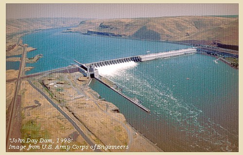
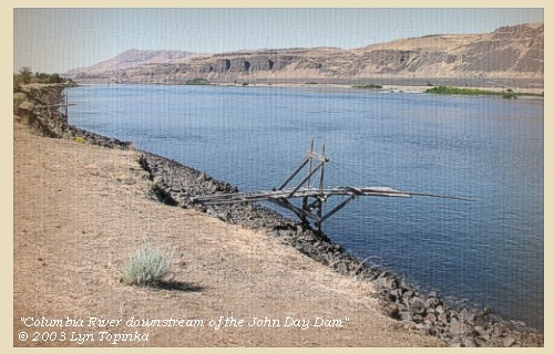
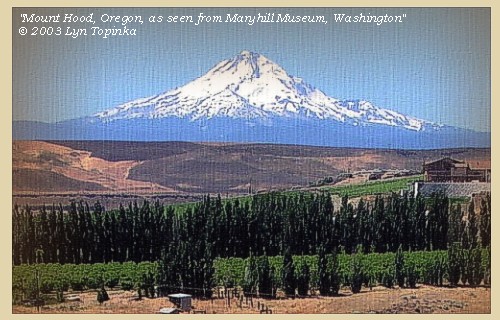
Rapids and Rivers Roosevelt and Arlington to the John Day Rapids, Rock Creek, Rapids in the John Day area, John Day River and LePage Park, John Day Dam, Downstream of the John Day Dam, Mount Hood |
CONTINUE
October 22 "Great Falls of the Columbia", Maryhill to Celilo |
|
To the Pacific - October 1805
Rapids and Rivers - Roosevelt and Arlington to the John Day |
| Lewis and Clark's camp of October 20, 1805 was on the Washington side of the Columbia River, near today's town of Roosevelt, and across from today's town of Arlington, Oregon. |
| Monday, October 21, 1805 |
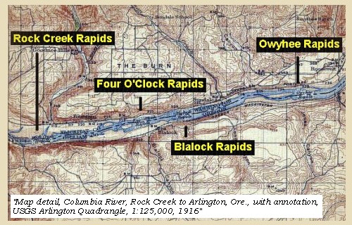
| The morning was cool, and the wind from the southwest. At five and a half miles we passed a small island, and one mile and a half further, another in the middle of the river, which has some rapid water near its head [Owyhee Rapids], and opposite to its lower extremity are eight cabins of Indians on the right side. We landed near them to breakfast ...... After breakfast we resumed our journey, and in the course of three miles passed a rapid [Blalock Rapids or Four O'clock Rapids ???] where large rocks were strewed across the river, and at the head of which on the right shore were two huts of Indians. We stopped here for the purpose of examining it, as we always do whenever any danger is to be apprehended, and send round by land all those who cannot swim. |
| Five miles further is another rapid [Rock Creek Rapids, sometimes Rock Rapids], formed by large rocks projecting from each side, above which were five huts of Indians on the right side, occupied like those we had already seen, in drying fish. |
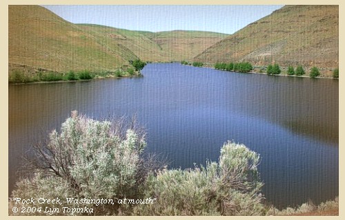
| Rock Creek Rapids is just downstream of the mouth of Rock Creek (Washington side). Lewis and Clark make no mention of Rock Creek on their journey downstream, but on their return in 1806, they camp next to the creek. |
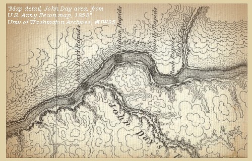
| One mile below this is the lower point of an island close to the right side, opposite to which on that shore, are two Indian huts. On the left side of the river at this place, are immense piles of rocks, which seem to have slipped from the cliffs under which they lie; they continue till spreading still farther into the river, at the distance of a mile from the island, they occasion a very dangerous rapid [Squally Rapids]; a little below which on the right side are five huts. For many miles the river is now narrow and obstructed with very large rocks thrown into its channel; the hills continue high and covered, as is very rarely the case, with a few low pine trees on their tops. Between three and four miles below the last rapid [Squally Rapids] occurs a second, which is also difficult [Indian Rapids], |
| "... maney large rocks on each Side at Some distance from Shore, ... crouded with hugh rocks Scattered in every Direction which renders the pasage verry Difficuelt a little above this rapid on the Lard. Side emence piles of rocks appears as if Sliped from the Clifts under which they lay, passed great number of rocks in every direction Scattered in the river ... much dificuelty in passing, the river is Crouded with rocks in every direction, ..." [Clark, October 21, 1805] |
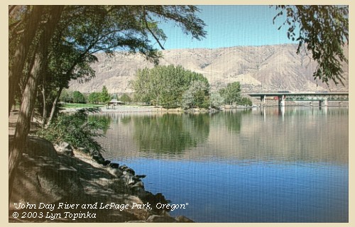
| and three miles below it is a small river [John Day River], which seems to rise in the open plains to the southeast, and falls in on the left. It is forty yards wide at its mouth; but discharges only a small quantity of water at present: we gave it the name of Lepage's river [John Day River] from Lepage one of our company. |
| "... to the mouth of a Small river on the Lardboard Side 40 yards wide descharges but little water at this time, and appears to take its Sourse in the Open plains to the S. E. from this place I proceved Some fiew Small pines on the tops of the high hills and bushes in the hollars. ..." [Clark, October 21, 1805] |
| Near this little river and immediately below it, we had to encounter a new rapid [John Day Rapids, today the site of the John Day Dam]. |
| "... imediately above & below this little river comences a rapid which is crouded with large rocks in every direction, the pasage both crooked and dificuelt, we halted at a Lodge to examine those noumerous Islands of rock which apd. to extend maney miles below ... after passing this rapid which we accomplished without loss; winding through between the hugh rocks for about 2 miles ..." [Clark, October 21, 1805] |
| The river is crowded in every direction, with large rocks and small rocky islands; the passage crooked and difficult, and for two miles we were obliged to wind with great care along the narrow channels and between the huge rocks. At the end of this rapid [John Day Rapids] are four huts of Indians on the right, and two miles below five more huts on the same side. Here we landed and passed the night, after making thirty-three miles. [Washington side, downstream of today's John Day Dam]. ...... |
| "... we proceeded on passed River hills and cliffs of rocks on each side. passed over a number of bad rockey rapids where the River is nearly filled with high dark couloured rocks the water divided in narrow deep channels, bad whorl pools ... we came about 32 miles this day and Camped at some Indian lodges close under high clifts of rocks on the Stard Side a handsome Spring flowed out of the clifts ..." [Ordway, October 21, 1805] |
| The hills in this neighbourhood are high and rugged, and a few scattered trees, either small pine or scrubby white oak, are occasionally seen on them. From the last rapids we also observed the conical mountain towards the southwest, which the Indians say is not far to the left of the great falls [Celilo Falls]. From its vicinity to that place we called it the Timm or Falls mountain. [Mount Hood] Among other things we observed some acorns, the fruit of the white oak. These they use as food either raw or roasted, and on inquiry informed us that they were procured from the Indians who live near the great falls. This place they designate by a name very commonly applied to it by the Indians, and highly expressive, the word 'Timm', which they pronounce so as to make it perfectly represent the sound of a distant cataract |
| "... from this rapid the Conocil mountain is S. W. which the Indians inform me is not far to the left of the great falls; this I call the 'Timm' or falls mountain it is high and the top is covered with Snow ..." [Clark, October 21, 1805] |
| The country through which we passed is furnished with several fine springs, which rise either high up the sides of the hills or else in the river meadows, and discharge themselves into the Columbia. We could not help remarking that almost universally the fishing establishments of the Indians, both on the Columbia and the waters of Lewis's river [Snake River], are on the right bank [Washington side of the Columbia]. On inquiry we were led to believe that the reason may be found in their fear of the Snake Indians; between whom and themselves, considering the warlike temper of that people, and the peaceful habits of the river tribes, it is very natural that the latter should be anxious to interpose so good a barrier. These Indians are described as residing on a great river to the south [Snake River], and always at war with the people of this neighbourhood. ...... |
|
|
|
The Camp - October 21, 1805:
Camped on the Washington side of the Columbia, downstream of the site of modern John Day Dam. |
| Home | Previous | Continue |
If you have questions or comments please contact: GS-CVO-WEB@usgs.gov
June/July 2004, Lyn Topinka
The Volcanoes of Lewis and Clark Home Page | CVO Home Page


