The Volcanoes of
Lewis and Clark
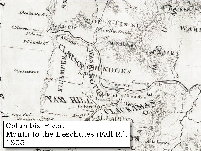
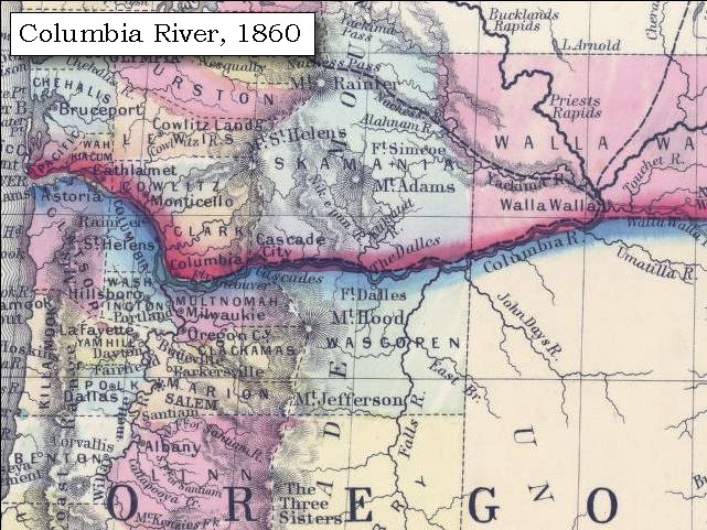
October 22, 1805
"Great Falls of the Columbia" - Maryhill to Celilo
 
Home
The Volcanoes of Lewis and Clark

Map of the Journey
Volcanoes, Basalt Plateaus, Major Rivers, etc.

The Volcanoes
Mount Adams, Mount Hood, Mount Jefferson, Mount Rainier, and Mount St. Helens

CALENDAR of the Journey
October 1805 to June 1806

Along the Journey
Pacific Northwest Maps - Columbia River, Volcanoes, Flood Basalts, Missoula Floods, Geology, etc.

The Corps of Discovery
The Journey of Lewis and Clark

About the Reference Materials
The Journals, Biddle/Allen, DeVoto, Gass, Moulton, Topo Maps, and others

USGS Lewis and Clark Links
Links to USGS Websites highlighting the Lewis and Clark Journey

Resources
Publications Referenced and Websites Visited


PREVIOUS

October 21
Rapids and Rivers, Roosevelt and Arlington to the John Day
October 22

"Great Falls of the Columbia"
Maryhill to Celilo

Five-Mile Rapids, U.S. Highway 97 Bridge, and Maryhill (Washington), Maryhill State Park, Mount Hood, Haystack Butte and the Columbia Hills, Miller Island, Deschutes River, Deschutes River State Recreation Area, "Great Falls of the Columbia", Celilo Falls and, Wishram (Washington), Celilo Locks and Canal
CONTINUE

October 23
"Great Falls of the Columbia"
 

On October 7, 1805, Lewis and Clark and the "Corps of Discovery" began their journey down the Clearwater River and into the volcanics of the Pacific Northwest. The Corps travelled from the Clearwater to the Snake and down the "Great Columbia", finally reaching the Pacific Ocean on November 15, 1805. Along the journey they encountered the lava flows of the Columbia Plateau, river channels carved by the great "Missoula Floods", and the awesome beauty of five Cascade Range volcanoes.

Map, Lewis and Clark in the Pacific Northwest, click for brief
                         summary
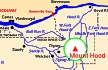
[Click map for brief summary about the area]


To the Pacific - October 1805
"Great Falls of the Columbia" - Maryhill to Celilo
 

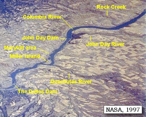
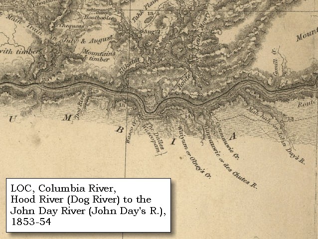
Lewis and Clark's camp of October 21, 1805, was on the Washington side of the Columbia, downstream of the site of modern John Day Dam, and upstream of the Maryhill area. On October 22, 1805, Lewis and Clark left the John Day area headed for the "Great Falls of the Columbia".

Tuesday, October 22, 1805
The morning was fair and calm. We left our camp at nine o'clock, and after going on for six miles came to the head of an island, and a very bad rapid [an 1858 map refers to as "Five Mile Rapids", today the site of the "Biggs Bridge"], where the rocks are scattered nearly across the river. Just above this and on the right side are six huts of Indians [Maryhill vicinity].


Along the Journey - October 22, 1805
U.S. Highway 97 Bridge as seen from Maryhill Museum, Washington, 2003

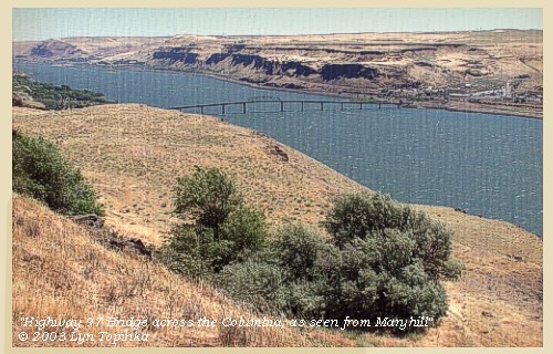
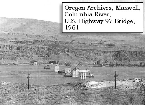
Five-Mile Rapids, U.S. Highway 97 Bridge, and Maryhill, Washington:
The "Biggs Bridge", also known as U.S. Highway 97, is located 13.6 miles above The Dalles Dam, and has a clearance of 88 feet at the center of the fixed highway span. The bridge joins Maryhill, Washington, and Biggs Junction, Oregon. Maryhill Museum, Maryhill State Park, and the Stonehenge Memorial are located on the Washington State side of the bridge. -- NOAA Office of Coast Survey Website, 2003


Map, 1858 Military recon map, Deschutes River Vicinity, click to enlarge Map, 1983, Maryhill, Washington, and Biggs, Oregon, click to enlarge NASA Image, 1994, Columbia River and the John Day area, click to enlarge NASA Image, 1997, Columbia River from The Dalles to Rock Creek, click to enlarge Image, 1961, U.S. Highway 97 (Biggs) Bridge, under construction, click to enlarge Image, 2003, Highway 97 from Maryhill, Washington
  1. 1858 Military Recon Map (section of original), Deschutes River confluence with the Columbia River. (Click to enlarge). Washington State is north (top) and Oregon is south (bottom). Miller Island is under the fold marks. "Deschutes Peak" today is called "Haystack Butte". Original Map: Map of military reconnaissance from Fort Dalles, Oregon, via Fort Wallah-Wallah, to Fort Taylor, Washington Territory, 1858. Shows approximate location of military road constructed 1859 to 1862. From: the report and maps of Captain John Mullan, United States Army G.P.O., 1863. -- Washington State University Library Archives Website, 2002
  2. 1983 Map, Maryhill, Washington, and Biggs, Oregon, vicinity (section of original). (Click to enlarge). Office of Coast Surveys, Historical Maps and Charts, Lake Celilo, 1983, Chart#18533, 1:20,000. -- NOAA Office of Coast Survey Website, 2004
  3. 1994, NASA Image, Columbia River and the John Day area (section of original). (Click to enlarge). View from space - Columbia River and the John Day area, west-northwest-looking, low-oblique photograph, September 1994. The Columbia River is running from bottom (east) to top (west). The John Day Dam is visible across the Columbia River. The John Day River enters the Columbia from the Oregon side (south, left of river, bottom center). The right of the river (north) is Washington State. NASA Earth from Space #STS064-112-092. -- NASA Earth from Space Website, 2002
  4. 1997, NASA Image, Columbia River from The Dalles to Rock Creek (Click to enlarge). View from space - northeast looking photograph of Columbia River, The Dalles Dam, John Day Dam, Miller Island, Maryhill area, Deschutes River, John Day River, and Rock Creek, 1997. The Columbia River flows upper right (east) to lower left (west). NASA Earth from Space #STS085-734-085. -- NASA Earth from Space Website, 2002
  5. 1961, Columbia River Bridge (U.S. Highway 97) bridge during construction, May 1961. (Click to enlarge). The U.S. Highway 97 Bridge connects Maryhill, Washington, with Biggs, Oregon. Oregon State Photo Archives #1945, Ben Maxwell Collection. -- Oregon State Photo Archives Website, 2003
  6. 2003, U.S. Highway 97 Bridge across the Columbia River, as seen from Maryhill Museum. (Click to enlarge). Copyright © 2003 Lyn Topinka, private archives, used with permission.


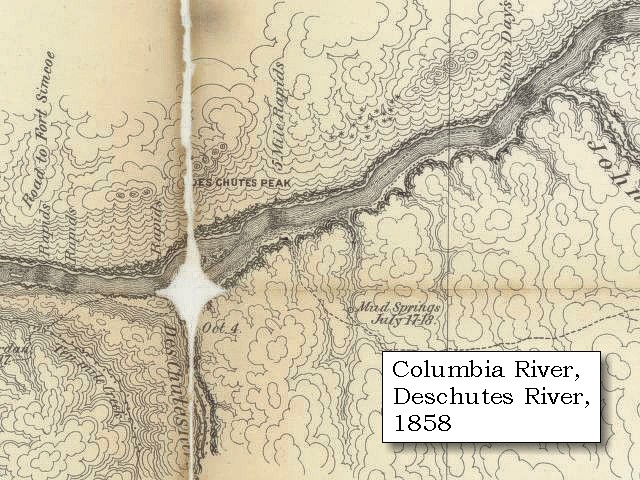
Maryhill, Washington:
In 1907 Sam Hill, a wealthy entrepreneur bought 6,000 acres of land overlooking the Columbia River with the intention of establishing a Quaker agricultural community. He chose the bluff which Maryhill Museum now occupies as the site for his own home, and in 1914 construction of his poured concrete mansion began. He named both his home and his land company Maryhill after his daughter, Mary. On a promontory on the east side of the Museum's gardens are a series of interpretive panels that include journal entries written by William Clark while the Corps of Discovery stopped at sites visible from the Museum. One panel relates how Lewis and Clark walked across the plateau where the Museum sits during their return trip on April 22, 1806. -- Washington State Parks and Recreation Website, 2002 and Maryhill Museum Website, 2002


Maryhill State Park:
Maryhill State Park is a 99-acre camping park with 4,700 feet of waterfront on the Columbia River in Klickitat County. The area is significant for its natural beauty, its access to the surrounding natural wonders and its cultural history. A full-scale model of Stonehenge stands near the park. Maryhill's Stonehenge is the first monument in our nation to honor the dead of World War I. It was built by Sam Hill as a tribute to the soldiers of Klickitat County who lost their lives. The structure is a full-scale replica of England's famous neolithic Stonehenge. The monument lies at the original Maryhill townsite, four miles east of the museum, just off Washington Scenic Route 14. -- Washington State Parks and Recreation Website, 2002 and Maryhill Museum Website, 2002

Geology of the area:
About 5 million years ago magma began pushing up into the crust of the earth below parts of the Horse Heaven Hills. The magma eventually broke through to the surface and began erupting lavas and forming cinder cones. The volcanism persisted until about a million years ago when the last volcano erupted lava that flowed down off the Columbia Hills and into the Columbia River near the Maryhill Museum. -- Steve Reidel, Pacific Northwest Laboratory Website, 2002


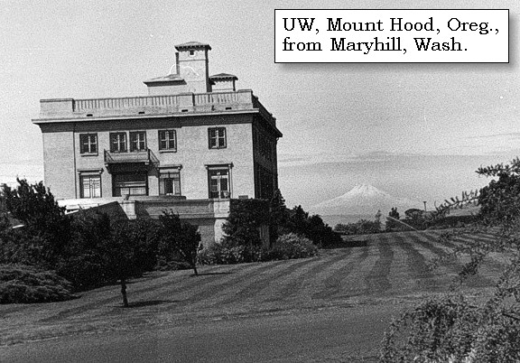
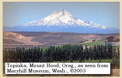
A fantastic view of Mount Hood can be seen from the hill at Maryhill Museum. The Corps noted the peak on their return trip in 1806, as they road horseback along the ridge -- see entry of April 22, 1806.


Along the Journey - October 22, 1805
Mount Hood, Oregon, from Maryhill Museum, Washington, 2003

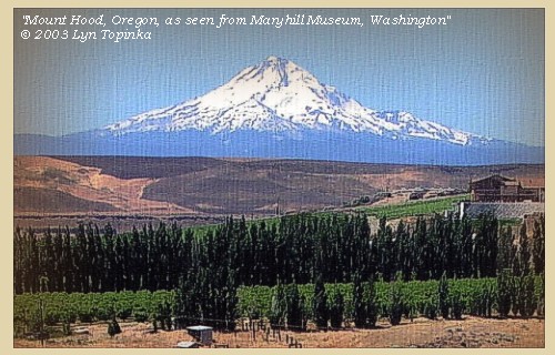
Mount Hood from Maryhill Museum:
Mount Hood, at 11,245 feet high, is the fourth highest peak in the Cascade Range and the highest in the state of Oregon. The peak dominates the skyline from the Portland, Oregon, metropolitan area to the wheat fields of Wasco and Sherman Counties of eastern Oregon.


Map, the Volcanoes of Lewis and Clark, click to enlarge Map, 1993, Mount Hood and Vicinity, click to enlarge Map, 1814, Lewis and Clark on the Columbia, click to enlarge Map, 1853, Washington and Oregon and the Columbia River, click to enlarge Map, 1855, Columbia River, Vancouver to the Pacific, click to enlarge Map, 1860, Columbia River, Washington, Oregon, click to enlarge Image, Mount Hood and the Maryhill Museum, click to enlarge Image, 2003, Mount Hood from Maryhill, Washington
  1. Map, "Lewis and Clark Volcano Sitings"
  2. 1993 Map, Mount Hood and Vicinity, showing river drainages which flow into the Columbia river. (Click to enlarge). Includes Hood River and the Sandy River. Map modified from: Brantley and Scott, 1993.
  3. 1814 Map, Lewis and Clark (section of original). (Click to enlarge.) Shows Mount Hood. From the "Nicholas Biddle/Paul Allen" 1814 publication. Original Map: "A Map of Lewis and Clark's Track, Across the Western Portion of North America, From the Mississippi to the Pacific Ocean". From: History of the expedition under the command of Captains Lewis and Clark : to the sources of the Missouri, thence across the Rocky Mountains and down the river Columbia to the Pacific Ocean : performed during the years 1804-5-6 : by order of the government of the United States / prepared for the press by Paul Allen. Philadelphia : Bradford and Insskeep, 1814. Harold B. Lee Library, Brigham Young University #upbover maps37. -- Brigham Young University, Harold B. Lee Library Website, 2004.
  4. 1853 Map, Washington and Oregon and the Columbia River, from the Clearwater River to the Snake River and down the Columbia River to the Pacific Ocean (section of original). (Click to enlarge). Includes: Clearwater River (Kooskooski), Lapwai Creek (Lapwai R.), Snake River (Saptin or Lewis R.), Columbia River (Columbia R.), Yakima River (Yakima R.), Walla Walla River (Wallawalla R.), Umatilla River (Umatilla R.), Willow Creek (Quesnells R.), John Day River (John day's R.), Deschutes River (Fall R.), Willamette River (Willammette R.), and Cowlitz River (Cowlitz R.). Original Map: "Map of California, Oregon, Washington, Utah, and New Mexico (1853)", by Thomas Cowperthwait & Co. Washington State University Archives #WSU22. -- Washington State University Library Collections Website, 2003
  5. 1855 Map, Columbia River from Vancouver to the Pacific, including Mount St. Helens (section of original). (Click to enlarge). Original Map: "Map of Oregon and Washington Territories: showing the proposed Northern Railroad route to the Pacific Ocean, by John Disturnell, 1855. University of Washington Archives #UW155. -- University of Washington Library Collections Website, 2002
  6. 1860 Map, Columbia River, Washington State, and Oregon (section of original). (Click to enlarge). Original Map: Map of Oregon, Washington, and British Columbia, (1860). This map dates between March 2nd, 1861 (when the Dakota Territory was formed) and March 4th, 1863 (when the Idaho Territory was formed from eastern Washington and western Dakota) Nearing retirement from a thirty year long and rather successful career, S. Augustus Mitchell printed this map showcasing Oregon, the Territory of Washington, and British Columbia. Washington became a territory in 1853, arguing that distances to Willamette Valley kept them from obtaining a voice in the Oregon territorial government. As this map shows, when it split from Oregon proper the Washington territory included parts of Wyoming and Montana and all of Idaho. Territorial government for Idaho would not be approved until 1863. When Mitchell retired he left the business for his son to manage. Washington State University Archives #WSU7. -- Washington State University Archives, 2004
  7. Mount Hood, Oregon, and the Maryhill Museum, Washington State. (Click to enlarge). Looking West at the Maryhill Museum with Mount Hood in the distance. University of Washington Photo Archives #WAS0564. -- University of Washington Library Archives Website, 2003
  8. 2003, Mount Hood, Oregon, as seen from from Maryhill Museum, Washington. (Click to enlarge). Copyright © 2003 Lyn Topinka, private archives, used with permission.


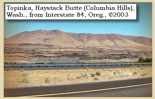
At the distance of two miles below, are five more huts; the inhabitants of which are all engaged in drying fish, and some of them in their canoes killing fish with gigs; [below Haystack Butte, Columbia Hills, Washington]


Along the Journey - October 22, 1805
Haystack Butte, 2003

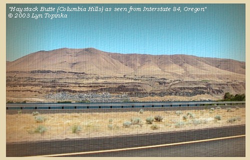
Haystack Butte (Columbia Hills):
Haystack Butte was known as "Des Chutes Peak" on an 1858 Military Recon map (see below), and is located on the Washington State side of the Columbia River, across from the mouth of the Deschutes River. Haystack Butte is part of the Columbia Hills, and is the tallest point in the area.


Map, 1858 Military recon map, Deschutes River Vicinity, click to enlarge Image, 2003, Haystack Butte
  1. 1858 Military Recon Map (section of original), Deschutes River confluence with the Columbia River. (Click to enlarge). Washington State is north (top) and Oregon is south (bottom). Miller Island is under the fold marks. "Deschutes Peak" today is called "Haystack Butte". Original Map: Map of military reconnaissance from Fort Dalles, Oregon, via Fort Wallah-Wallah, to Fort Taylor, Washington Territory, 1858. Shows approximate location of military road constructed 1859 to 1862. From: the report and maps of Captain John Mullan, United States Army G.P.O., 1863. -- Washington State University Library Archives Website, 2002
  2. 2003, Haystack Butte, Washington (Columbia Hills), as seen from Interstate 84, Oregon. (Click to enlarge). Copyright © 2003 Lyn Topinka, private archives, used with permission.


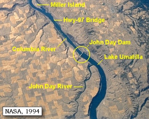
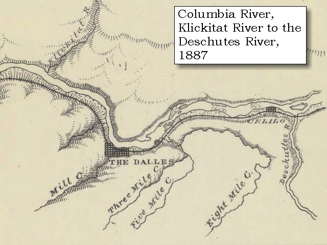
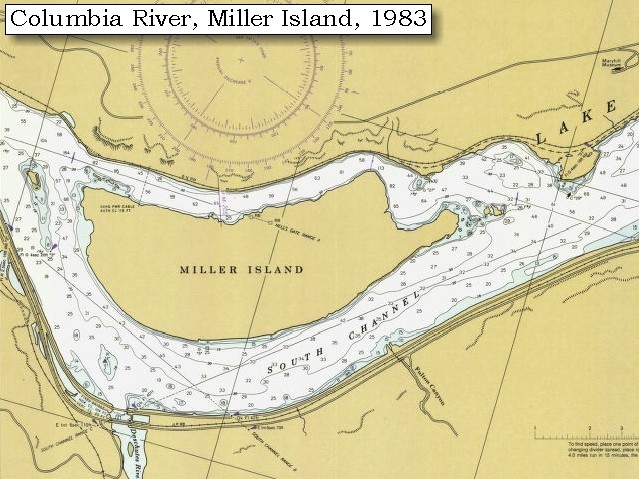
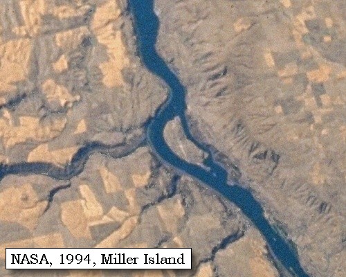
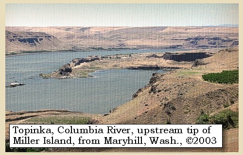
opposite to this establishment is a small island in a bend towards the right, on which there were such quantities of fish that we counted twenty stacks of dried and pounded salmon. This small island is at the upper point of one much larger [Miller Island] , the sides of which are high uneven rocks, jutting over the water: here there is a bad rapid [Deschutes Rapids].


Along the Journey - October 22, 1805
Upstream tip of Miller Island, 2003

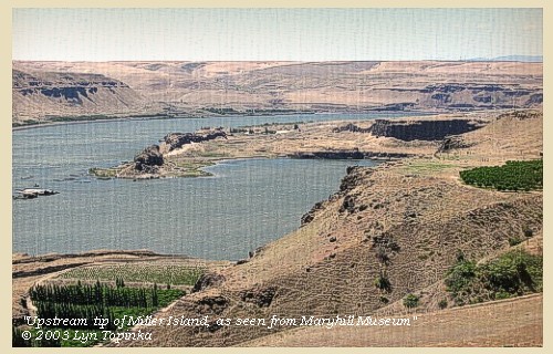
Miller Island:
Miller Island is located at the mouth of the Deschutes River. This large island was given a descriptive name, "Rock Island" as Lewis and Clark headed towards the "Great Falls of the Columbia" and their first portage of the Columbia River rapids. Known today as Miller Island, the island was probably named after an early pioneer in the region. -- Washington State Historical Society Website, 2002


Map, 1858 Military recon map, Deschutes River Vicinity, click to enlarge Map, 1859, Columbia River, Klickitat River and Fort Dalles, click to enlarge Map, 1887, The Dalles vicinity, click to enlarge Map, 1983, Miller Island and the Deschutes River, click to enlarge NASA Image, 1997, Columbia River from The Dalles to Rock Creek, click to enlarge NASA Image, 1994, Deschutes Drainage including Miller Island, click to enlarge NASA Image, 1994, Miller Island, click to enlarge Image, 2003, Upstream tip of Miller Island
  1. 1858 Military Recon Map (section of original), Deschutes River confluence with the Columbia River. (Click to enlarge). Washington State is north (top) and Oregon is south (bottom). Miller Island is under the fold marks. "Deschutes Peak" today is called "Haystack Butte". Original Map: Map of military reconnaissance from Fort Dalles, Oregon, via Fort Wallah-Wallah, to Fort Taylor, Washington Territory, 1858. Shows approximate location of military road constructed 1859 to 1862. From: the report and maps of Captain John Mullan, United States Army G.P.O., 1863. -- Washington State University Library Archives Website, 2002
  2. 1859 Map, Columbia River, including the Klickitat River (Klikatat Riv.), Fort Dalles, and the Deschutes River (Fall River) (section of original). (Click to enlarge). Original Map: "Map Exhibiting the Routes between Fort Dalles and the Great Salt Lake", By Bvt.2d Lieut. Joseph Dixon, Topl. Engrs. From Explorations made by him while attached to the Wagon Road Expedition to the Valley of the Great Salt Lake, under the command of Capt. H.D. Wallen, 4th Inft., Compiled under the direction of Capt. Geo. Thom, Topl. Engr., from the orders of Brig. Gen. W.S. Harney commanding the Department of Oregon, 1859. Publisher: Bureau of Topog. Engineers, 1860, UU Library ID: #G4240_1859_D5., Scale: 1:1,300,000. -- University of Utah Library, J.Willard Marriott Digitized Collections Website, 2004
  3. 1887 Map (section of original), Columbia River at The Dalles, including the Deschutes River and Miller Island. (Click to enlarge). Original Map: The Columbia River from Celilo to the mouth showing locations of the salmon fisheries, 1887. Scale ca. 1:375,000, Relief shown by hachures. U.S. Army Corps of Engineers, Engineer Office, G.P.O. 1888. University of Washington Archives #UW128. -- University of Washington Library Archives Website, 2002
  4. 1983 Map, Miller Island and the Deschutes River (section of original). (Click to enlarge). Office of Coast Surveys, Historical Maps and Charts, Lake Celilo, 1983, Chart#18533, 1:20,000. -- NOAA Office of Coast Survey Website, 2004
  5. 1997, NASA Image, Columbia River from The Dalles to Rock Creek (Click to enlarge). View from space - northeast looking photograph of Columbia River, The Dalles Dam, John Day Dam, Miller Island, Maryhill area, Deschutes River, John Day River, and Rock Creek, 1997. The Columbia River flows upper right (east) to lower left (west). NASA Earth from Space #STS085-734-085. -- NASA Earth from Space Website, 2002
  6. 1994, NASA Image, Deschutes drainage, including Miller Island (section of original). (Click to enlarge). View from space - Columbia River and the Deschutes River drainage, west-northwest-looking, low-oblique photograph, September 1994. Miller Island is visible in the Columbia River (right side of view) at the mouth of the Deschutes River (center of view). The Cascades are the dark coloration at the top of the view. NASA Earth from Space #STS064-112-092. -- NASA Earth from Space Website, 2002
  7. 1994, NASA Image, Miller Island (section of original). (Click to enlarge). View from space - Columbia River, with the Deschutes River and Miller Island, west-northwest-looking, low-oblique photograph, September 1994. Miller Island is located in the Columbia River at the mouth of the Deschutes River. Washington State is to the right of the Columbia (north) and Oregon is to the left (south). The ridge visible on the Washington side of the Columbia is Columbia Hills. NASA Earth from Space #STS064-112-092. -- NASA Earth from Space Website, 2002
  8. 2003, Upstream tip of Miller Island. (Click to enlarge). Copyright © 2003 Lyn Topinka, private archives, used with permission.


The island [Miller Island] continues for four miles, and at the middle of it is a large river [Deschutes River], which appears to come from the southeast, and empties itself on the left. We landed just above its mouth in order to examine it, and soon found the route intercepted by a deep, narrow channel, running into the Columbia above the large entrance, so as to form a dry and rich island about 400 yards wide and eight hundred long. ......
"... this River haveing no Indian name that we could find out, except "the River on which the Snake Indians live", we think it best to leave the nameing of it untill our return. ..." [Clark, October 22, 1805]


Along the Journey - October 22, 1805
Deschutes River, 2003

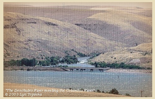
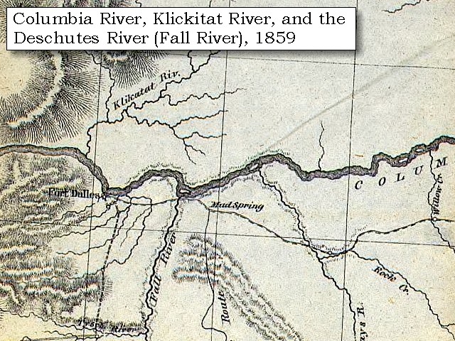
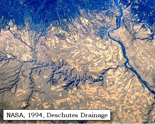
Deschutes River:
Lewis and Clark first called the Deschutes "Clark's River" and that name appears on the route map and in their journals. Later, to avoid confusion with the previously named "Clark's Fork" [Pend Oreille River], Lewis and Clark changed the river's name to it's Indian name "Towahnahiooks," which with its various other spellings is the Chinook term for "enemies," referring to a river coming from southern Paiute Indian territory.
"... To this river, moreover, which we have hitherto called Clarke's river, which rises in the southwest mountains, we restored the name of Towahnahiooks, the name by which it is known to the Eneeshurs ..." [Clark, May 6, 1806]
In the fur trading period the French Canadians called the drainage "Riviere des Chutes," French for "river of the falls," because of its close proximity to the "La Grand Dalle de la Columbia." The tendency to simplify place names with local usage has shortened the name to "Deschutes." The Deschutes River originates on the east slope of the Cascade Mountains southwest of Bend. The river flows north through Central Oregon and enters the Columbia River at River Mile (RM) 205. The basin drains approximately 10,500 square miles and is second in size only to the Willamette River watershed in Oregon. The basin is separated into upper and lower sections, the dividing point between the sections being the Pelton/Round Butte at RM 100. The lower Deschutes River basin covers approximately 2,700 square miles and has 760 miles of perennial streams and 1,440 miles of intermittent streams. Major tributaries to the lower Deschutes River include the Warm Springs and White rivers and Shitike, Trout, Bakeoven, and Buck Hollow creeks. Nineteen high mountain lakes, six lower elevation lakes and small reservoirs, and numerous man-made or natural small ponds are also found. The lower Deschutes River basin lies in the southern portion of the Columbia Basin physiographic province. Loess, volcanic ash and pumice have been laid down during recent geologic times, with much of the original deposits of loess and ash having been eroded from the uplands and deposited along streams. The upper Deschutes River basin encompasses the upper 132 river miles of the Deschutes River and drains approximately 2,200 square miles. -- Columbia Basin Fish and Wildlife Authority Website, 2004, and Washington State Historical Society Website, 2004, "Lasting Legacy".


Map, 1814, Lewis and Clark on the Columbia, click to enlarge Map, 1853, Washington and Oregon and the Columbia River, click to enlarge Map, 1854, Columbia River, Hood River to the John Day, click to enlarge Map, 1855, Columbia River, Walla Walla to Vancouver, click to enlarge Map, 1858 Military recon map, Deschutes River Vicinity, click to enlarge Map, 1859, Columbia River, Klickitat River and Fort Dalles, click to enlarge Map, 1887, The Dalles vicinity, click to enlarge Map, 1983, Miller Island and the Deschutes River, click to enlarge NASA Image, 1997, Columbia River from The Dalles to Rock Creek, click to enlarge NASA Image, 1994, Deschutes Drainage, click to enlarge Image, 1910, Junction of the Deschutes River with the Columbia, click to enlarge Image, 2003, Deschutes River
  1. 1814 Map, Lewis and Clark's map of the Columbia River (section of original). (Click to enlarge.) Shows the Deschutes River ("To-war-na-he-ooks R."). Map also includes three of the five volcanoes Lewis and Clark saw and commented on. While the journals mention the expedition seeing Mount Adams, it does not appear on their map. Mount Jefferson is just visible to the south (bottom) and Mount Rainier is to the north but off the map. From the "Nicholas Biddle/Paul Allen" 1814 publication. Original Map: "A Map of Lewis and Clark's Track, Across the Western Portion of North America, From the Mississippi to the Pacific Ocean". From: History of the expedition under the command of Captains Lewis and Clark : to the sources of the Missouri, thence across the Rocky Mountains and down the river Columbia to the Pacific Ocean : performed during the years 1804-5-6 : by order of the government of the United States / prepared for the press by Paul Allen. Philadelphia : Bradford and Insskeep, 1814. Harold B. Lee Library, Brigham Young University #upbover maps37. -- Brigham Young University, Harold B. Lee Library Website, 2004.
  2. 1853 Map, Washington and Oregon and the Columbia River, from the Clearwater River to the Snake River and down the Columbia River to the Pacific Ocean (section of original). (Click to enlarge). Includes: Clearwater River (Kooskooski), Lapwai Creek (Lapwai R.), Snake River (Saptin or Lewis R.), Columbia River (Columbia R.), Yakima River (Yakima R.), Walla Walla River (Wallawalla R.), Umatilla River (Umatilla R.), Willow Creek (Quesnells R.), John Day River (John day's R.), Deschutes River (Fall R.), Willamette River (Willammette R.), and Cowlitz River (Cowlitz R.). Original Map: "Map of California, Oregon, Washington, Utah, and New Mexico (1853)", by Thomas Cowperthwait & Co. Washington State University Archives #WSU22. -- Washington State University Library Collections Website, 2003
  3. 1853-54 Map, Columbia River, including the Hood River to John Day area (section of original). (Click to enlarge). Includes Hood River (Dog River), Klickitat River (Klikatat R.), Mill Creek (?) (Wasco Ck.), The Dalles, The Deschutes (Wanwauwie or des Chutes R.), the John Day River (Mah hah or John Day's R.), and Rock Creek (Camill Cr.). Original Map: "Rocky Mountains to Puget Sound : from explorations and surveys / made under the direction of the Hon. Jefferson Davis, Secretary of War by Isaac I. Stevens Governor of Washington Territory, 1853-4." Inset: (Supplementary sketch) Reconnaissance of the railroad route from Wallawalla to Seattle via Yak-e-mah River & Snoqualmie Pass. By A. W. Tinkham in January 1854. Drawn by J. R. P. Mechlin. 20 x 28 cm. Topographer, John Lambert, Published in Washington D.C., 1859, 1:1,200,000, Notes: From the U.S. War Department, Explorations and Surveys for a Railroad Route from the Mississippi River to the Pacific Ocean, Topographical Maps, to Illustrate the Various Reports, U.S. Library of Congress American Memories Reference "LC Railroad Maps #156". -- U.S. Library of Congress, American Memories Website, 2004
  4. 1855 Map, Columbia River, including the Deschutes River (Fall R.) (section of original). (Click to enlarge). Original Map: "Map of Oregon and Washington Territories: showing the proposed Northern Railroad route to the Pacific Ocean, by John Disturnell, 1855. University of Washington Archives #UW155. -- University of Washington Library Collections Website, 2002
  5. 1858 Military Recon Map (section of original), Deschutes River confluence with the Columbia River. (Click to enlarge). Washington State is north (top) and Oregon is south (bottom). Miller Island is under the fold marks. "Deschutes Peak" today is called "Haystack Butte". Original Map: Map of military reconnaissance from Fort Dalles, Oregon, via Fort Wallah-Wallah, to Fort Taylor, Washington Territory, 1858. Shows approximate location of military road constructed 1859 to 1862. From: the report and maps of Captain John Mullan, United States Army G.P.O., 1863. -- Washington State University Library Archives Website, 2002
  6. 1859 Map, Columbia River, including the Klickitat River (Klikatat Riv.), Fort Dalles, and the Deschutes River (Fall River) (section of original). (Click to enlarge). Original Map: "Map Exhibiting the Routes between Fort Dalles and the Great Salt Lake", By Bvt.2d Lieut. Joseph Dixon, Topl. Engrs. From Explorations made by him while attached to the Wagon Road Expedition to the Valley of the Great Salt Lake, under the command of Capt. H.D. Wallen, 4th Inft., Compiled under the direction of Capt. Geo. Thom, Topl. Engr., from the orders of Brig. Gen. W.S. Harney commanding the Department of Oregon, 1859. Publisher: Bureau of Topog. Engineers, 1860, UU Library ID: #G4240_1859_D5., Scale: 1:1,300,000. -- University of Utah Library, J.Willard Marriott Digitized Collections Website, 2004
  7. 1887 Map (section of original), Columbia River at The Dalles, including the Deschutes River and Miller Island. (Click to enlarge). Original Map: The Columbia River from Celilo to the mouth showing locations of the salmon fisheries, 1887. Scale ca. 1:375,000, Relief shown by hachures. U.S. Army Corps of Engineers, Engineer Office, G.P.O. 1888. University of Washington Archives #UW128. -- University of Washington Library Archives Website, 2002
  8. 1983 Map, Miller Island and the Deschutes River (section of original). (Click to enlarge). Office of Coast Surveys, Historical Maps and Charts, Lake Celilo, 1983, Chart#18533, 1:20,000. -- NOAA Office of Coast Survey Website, 2004
  9. 1997, NASA Image, Columbia River from The Dalles to Rock Creek (Click to enlarge). View from space - northeast looking photograph of Columbia River, The Dalles Dam, John Day Dam, Miller Island, Maryhill area, Deschutes River, John Day River, and Rock Creek, 1997. The Columbia River flows upper right (east) to lower left (west). NASA Earth from Space #STS085-734-085. -- NASA Earth from Space Website, 2002
  10. 1994, NASA Image, Deschutes drainage, including Miller Island (section of original). (Click to enlarge). View from space - Columbia River and the Deschutes River drainage, west-northwest-looking, low-oblique photograph, September 1994. Miller Island is visible in the Columbia River (right side of view) at the mouth of the Deschutes River (center of view). The Cascades are the dark coloration at the top of the view. NASA Earth from Space #STS064-112-092. -- NASA Earth from Space Website, 2002
  11. 1910, Junction of the Deschutes River with the Columbia River. (Click to enlarge). Oregon Historical Society OrHi#24347, also ID#905-D, Columbia Gorge Discovery Center Catalogue #2001.05.008. -- Columbia Gorge Discovery Center Website, 2004.
  12. 2003, Deschutes River, Oregon, as seen from Washington State Highway 14. (Click to enlarge). Copyright © 2003 Lyn Topinka, private archives, used with permission.


Deschutes River State Recreation Area:
The Deschutes River State Recreation Area is a tree-shaded overnight oasis for campers. The sparkle-laden, swift green rush of the Deschutes converges with the Columbia here, and there's no better place for family outing activities like hiking, biking, camping, rafting, world-class steelhead and trout fishing and equestrian trail riding. The Deschutes, which is both a national and state scenic waterway, drops about a quarter of a mile in its final 100 miles as it twists through canyons 700 to 2,200 feet deep. -- Oregon State Parks and Recreation Website, 2002


We reached the river about a quarter of a mile above its mouth, at a place where a large body of water is compressed within a channel of about two hundred yards in width, where it foams over rocks, many of which are above the surface of the water. These narrows are the end of a rapid [an 1858 map calls this "Five Mile Rapids"] which extends two miles back, where the river is closely confined between two high hills, below which it is divided by numbers of large rocks and small islands, covered with a low growth of timber. This river, which is called by the Indians Towahnahiooks [Deschutes River], is two hundred yards wide at its mouth, has a very rapid current, and contributes about one fourth as much water as the Columbia possesses before the junction. Immediately at the entrance are three sand islands, and near it the head of an island [???] which runs parallel to the large rocky island [Miller Island].

We now returned to our boats, and passing the mouth of the Towahnahiooks [Deschutes River] went between the islands. At the distance of two miles we reached the lower end of this rocky island [Miller Island], where were eight huts of Indians. Here too, we saw some large logs of wood, which were most probably rafted down the Towahnahiooks [Deschutes River]; and a mile below, on the right bank, were sixteen lodges of Indians, with whom we stopped to smoke.


"Great Falls of the Columbia"
Tuesday, October 22, 1805 - Continued
Then at the distance of about a mile passed six more huts on the same side, nearly opposite the lower extremity of the island [???], which has its upper end in the mouth of the Towahnahiooks [Deschutes River]. Two miles below we came to seventeen huts on the right side of the river, situated at the commencement of the pitch [Wishram, Washington, vicinity] which includes the great falls [Celilo Falls].
"... 6 miles below the upper mouth of 'Towornehiooks' River the commencement of the pitch of the great falls, opposit on the Stard. Side is 17 Lodges of the nativs we landed and walked down accompanied by an old man to view the falls, and the best rout for to make a portage which we Soon discovered was much nearest on the Stard. Side, and the distance 1200 yards one third of the way on a rock, about 200 yards over a loose Sand collected in a hollar blown by the winds from the bottoms below which was disagreeable to pass, as it was steep and loose. ..." [Clark, October 22, 1805]


Along the Journey - October 22, 1805
Celilo Falls, ca.1940

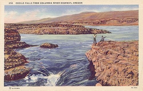
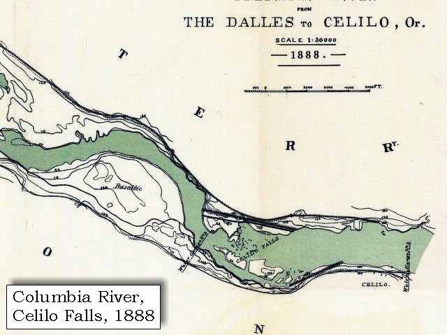
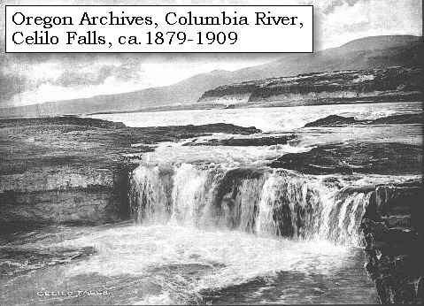
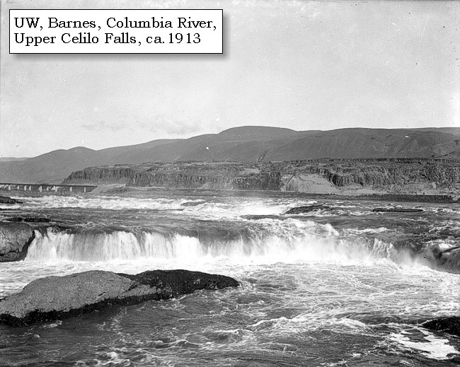
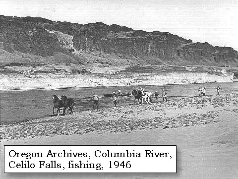
Celilo Falls ("Great Falls of the Columbia"):
Celilo Falls was known as the "Great Falls of the Columbia". The Columbia River cut into basalt rock to create a constriction of the river with a twenty-foot falls followed by a mile of narrow, channeled rapids with a drop of eight feet in river elevation. The Lewis and Clark expedition arrived at the "Great Falls of the Columbia" in late October, 1805, and were forced to portage around to continue on downriver. In the spring of 1806 they had to pass through the falls again on their journey home. The Celilo Falls were drowned in 1957 with the construction of The Dalles Dam. -- Washington State University Library Collections Website, 2002, Washington State Historical Society Website, 2002


Map, 1814, Great Falls of the Columbia, click to enlarge Map, 1887, The Dalles vicinity, click to enlarge Map, 1888, Celilo Falls and Vicinity, click to enlarge Map, 1983, Celilo Falls, click to enlarge Map, 1983, Celilo Falls, Wishram, click to enlarge Image, ca.1879-1909, Celilo Falls, click to enlarge Image, 1900, Celilo Falls, click to enlarge Image, ca.1913, Upper Celilo Falls, click to enlarge Image, ca.1937, Celilo Falls, click to enlarge Image, Celilo Falls, click to enlarge Penny Postcard, ca.1940, Basalt of Celilo Falls, click to enlarge Image, 1946, Celilo Falls area, click to enlarge Image, 2003, Celilo Park, Wishram, and Mount Hood
  1. 1814 Map, Great Falls of the Columbia. (Click to enlarge). This map is found in Travels to the source of the Missouri River and across the American continent to the Pacific Ocean : performed by order of the government of the United States, in the years 1804, 1805, and 1806, by Captains Lewis and Clarke. Published from the official report, 1814. -- Washington State University Library Archives Website, 2002
  2. 1887 Map (section of original), Columbia River at The Dalles. (Click to enlarge). Original Map: The Columbia River from Celilo to the mouth showing locations of the salmon fisheries, 1887. Scale ca. 1:375,000, Relief shown by hachures. U.S. Army Corps of Engineers, Engineer Office, G.P.O. 1888. University of Washington Archives #UW128. -- University of Washington Library Archives Website, 2002
  3. 1888 Map (section of original), Columbia River at Celilo Falls. (Click to enlarge). Original Map: Map of Columbia River from The Dalles to Celilo, Oregon, 1880. Scale 1:30,000. Relief shown by contours. Shows a section of the Columbia River, including fall and rapids, water gauges, and "basaltic" region. Original map is reduced from sheet 1 and 2, survey of 1879-1880, Published G.P.O. 1889. University of Washington Archives #UW66. -- University of Washington Library Archives Website, 2004
  4. 1983 Map, Celilo Falls. (Click to enlarge). Office of Coast Surveys, Historical Maps and Charts, Lake Celilo, 1983, Chart#18533, 1:20,000. -- NOAA Office of Coast Survey Website, 2004
  5. 1983 Map, Celilo Falls and Wishram. (Click to enlarge). Office of Coast Surveys, Historical Maps and Charts, Lake Celilo, 1983, Chart#18533, 1:20,000. -- NOAA Office of Coast Survey Website, 2004
  6. ca.1879-1909, A scene in the region served by the Oregon Railway & Navigation Company between 1879-1909. (Click to enlarge). Oregon State Archives Photograph, Salem Public Library Collection. Photograph Date: 1879-1909. -- Oregon State Archives Website, 2002
  7. 1900, Celilo Falls. (Click to enlarge). Celilo Falls on the Columbia, by Benjamin Gifford, 1900. Oregon Historical Society #OrHi89622. -- Oregon Historical Society Archives Website, 2002
  8. ca.1913, Upper Celilo Falls. (Click to enlarge). Photo by Albert Henry Barnes, ca.1913. University of Washington A.H. Barnes Collection #BAR010. -- University of Washington Library Archives, 2003
  9. ca.1937, Fishing at Celilo Falls. (Click to enlarge). The men stand on platforms and fish for the salmon with nets on long poles. Overhead are the cables used to transport people in a small cable car to an island in the river. The Celilo Falls are in the background. Photographer: Ralph Gifford. Photograph Date: ca. 1937. Oregon State Archives, Salem Public Library Collection # OHDG211. -- Oregon State Archives Website, 2002
  10. Native Americans fishing off platforms at Celilo Falls on the Columbia River, Oregon. U.S. Army Corps of Engineers Historic Library #700-07. -- U.S. Army Corps of Engineers Website, 2002
  11. ca.1940, Penny Postcard, Basalt at Celilo Falls. (Click to enlarge). "Cecilo (sic) Falls from Columbia River Highway, Oregon". #858, Wesley Andrews Co., Portland, Oregon. -- L.Topinka private collection, 2003, used with permission
  12. 1946, Horse seining for salmon on the Columbia River near Celilo Falls. (Click to enlarge). The horses are used to pull the heavy nets. Oregon State Archives Oregon State Highways Division Photograph #OHD2716. Photographer: Rosin. Photograph Date: September 10, 1946. -- Oregon State Archives Website, 2003
  13. 2003, Looking downstream on the Columbia River at the Celilo Falls area. (Click to enlarge). Celilo Park, Oregon is on the left and Wishram, Washington is on the right. Mount Hood, Oregon, is in the distance. Image from Washington State Highway 14. Copyright © 2003 Lyn Topinka, private archives, used with permission.


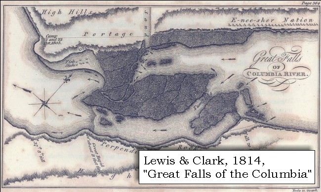
Here we halted, and immediately on landing walked down, accompanied by an old Indian from the huts, in order to examine the falls, and ascertain on which side we could make a portage most easily. We soon discovered that the nearest route was on the right side [Washington side, Wishram area], and therefore dropped down to the head of the rapid, unloaded the canoes and took all the baggage over by land to the foot of the rapid. The distance is twelve hundred yards.

Mount Hood, Oregon is visible along this stretch of the Columbia River.


Along the Journey - October 22, 1805
Columbia River, Celilo Park and Wishram, 2003

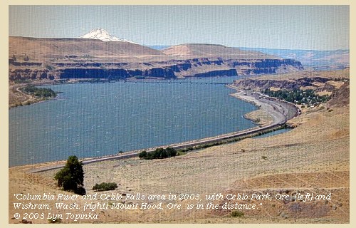
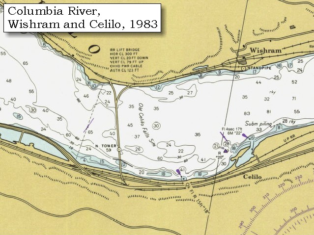
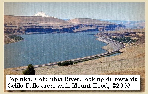
Celilo Falls area and Wishram today:
Today the Celilo Falls area has been inundated with the waters of Lake Celilo, the reservoir behind The Dalles Dam. Across from Wishram, Washington, is now Celilo Park, Oregon.


Map, 1814, Great Falls of the Columbia, click to enlarge Map, 1983, Celilo Falls, click to enlarge Map, 1983, Celilo Falls, Wishram, click to enlarge Image, 2003, Celilo Park, Wishram, and Mount Hood
  1. 1814 Map, Great Falls of the Columbia. (Click to enlarge). This map is found in Travels to the source of the Missouri River and across the American continent to the Pacific Ocean : performed by order of the government of the United States, in the years 1804, 1805, and 1806, by Captains Lewis and Clarke. Published from the official report, 1814. -- Washington State University Library Archives Website, 2002
  2. 1983 Map, Celilo Falls. (Click to enlarge). Office of Coast Surveys, Historical Maps and Charts, Lake Celilo, 1983, Chart#18533, 1:20,000. -- NOAA Office of Coast Survey Website, 2004
  3. 1983 Map, Celilo Falls and Wishram. (Click to enlarge). Office of Coast Surveys, Historical Maps and Charts, Lake Celilo, 1983, Chart#18533, 1:20,000. -- NOAA Office of Coast Survey Website, 2004
  4. 2003, Looking downstream on the Columbia River at the Celilo Falls area. (Click to enlarge). Celilo Park, Oregon is on the left and Wishram, Washington is on the right. Mount Hood, Oregon, is in the distance. Image from Washington State Highway 14. Copyright © 2003 Lyn Topinka, private archives, used with permission.


On setting out we crossed a solid rock, about one third of the whole distance; then reached a space of two hundred yards wide, which forms a hollow, where the loose sand from the low grounds has been driven by the winds, and is steep and loose, and therefore disagreeable to pass; the rest of the route is over firm and solid ground. The labour of crossing would have been very inconvenient, if the Indians had not assisted us in carrying some of the heavy articles on their horses; but for this service they repaid themselves so adroitly, that on reaching the foot of the rapids we formed a camp in a position which might secure us from the pilfering of the natives, which we apprehend much more than we do their hostilities. ......
"... the waters is divided into Several narrow chanels which pass through a hard black rock forming Islands of rocks at this Stage of the water ..." [Clark, October 22, 1805]

In 1905, one-hundred years after Lewis and Clark's passage through this area, the Celilo Canal and Locks were built.


Along the Journey - October 22, 1805
Celilo Canal and barge, 1953

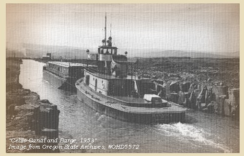
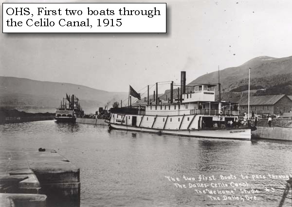
Celilo Locks and Canal:
Prior to 1863, boats operating on the upper river above Celilo and those coming upriver to The Dalles were linked by a wagon-road portage in order to avoid the treacherous rapids. In 1863, the Oregon Steam Navigation Company completed a 13-mile iron-railed portage line along what had been known as Thompson's Portage, between The Dalles and Celilo on the Oregon shore. The Dalles - Celilo railroad and connecting river steamers operated regularly for a number of years. In October 1905, the U.S. Army Corps of Engineers began work on The Dalles - Celilo Canal, one of the most significant early projects of the Corps' Portland District. The 8 1/2-mile-long canal consisted of five locks, each with an eight-foot lift. The Corps completed and officially opened the canal on May 5, 1915. This canal provided passage around Celilo Falls and the Long Narrows until The Dalles Dam replaced it in 1957. The filling of the reservoir behind The Dalles Dam in March 1957 inundated the canal, ending its 40-year history. Traffic now pass through the navigation lock on the Washington shore of the Project. -- U.S. Army Corps of Engineers Website, 2002, and Center for Columbia River History Website, 2002


Image, 1914, Celilo Canal, click to enlarge Image, 1915, First two boats through Celilo Canal, click to enlarge Image, 1953, Celilo Canal, click to enlarge
  1. 1914, Celilo Canal. (Click to enlarge). This 1914 photograph shows the river before dams and reservoirs changed the flow. Oregon State Archives, Water Resources Department Records, Photographs, and Negatives, #OWR0141. -- Oregon State Archives Website, 2002
  2. 1915, First two boats through the Celilo Canal. (Click to enlarge). The Inland Empire and the J.M. Teal, Photograph Date: 1915, Photographer: "Welcome Sutdio", The Dalles, Oregon. Oregon Historical Society #95715, #2395, Columbia Gorge Discovery Center Catalogue #2001.06.16. -- Columbia Gorge Discovery Center Website, 2004
  3. 1953, Celilo Canal. (Click to enlarge). A tug is pushing a grain barge down the Canal. Oregon State Archives, Oregon Highways Division, #OHD5572. -- Oregon State Archives Website, 2002


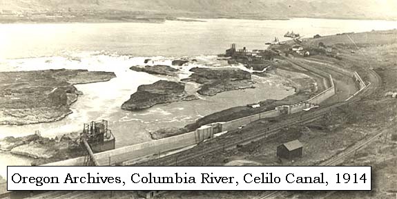
Besides fish, these people supplied us with filberts and berries, and we purchased a dog for supper; but it was with much difficulty that we were able to buy wood enough to cook it. In the course of the day we were visited by many Indians, from whom we learnt that the principal chiefs of the bands, residing in this neighbourhood, are now hunting in the mountains towards the southwest. [Cascade Range] On that side of the river [Oregon side] none of the Indians have any permanent habitations, and on inquiry we were confirmed in our belief that it was for fear of attacks from the Snake Indians with whom they are at war. This nation they represent as very numerous, and residing in a great number of villages on the Towahnahiooks [Deschutes River], where they live principally on salmon. That river [Deschutes River] they add is not obstructed by rapids above its mouth, but there becomes large and reaches to a considerable distance: the first villages of the Snake Indians on that river being twelve days' journey on a course about southeast from this place.


Along the Journey - October 22, 1805
The Camp - October 22 and 23, 1805:
Lewis and Clark's camp of October 22 and 23, 1805, was on the Washington side of the Columbia River, downstream of Wishram, Washington, and across from Oregon's Celilo Park.


Map, 1814, Great Falls of the Columbia, click to enlarge
  1. 1814 Map, Great Falls of the Columbia. (Click to enlarge). This map is found in Travels to the source of the Missouri River and across the American continent to the Pacific Ocean : performed by order of the government of the United States, in the years 1804, 1805, and 1806, by Captains Lewis and Clarke. Published from the official report, 1814. -- Washington State University Library Archives Website, 2002


Home Previous Continue


If you have questions or comments please contact: GS-CVO-WEB@usgs.gov
June/July 2004, Lyn Topinka
The Volcanoes of Lewis and Clark Home Page | CVO Home Page