The Volcanoes of
Lewis and Clark
October 20, 1805
Islands and Ridges - Umatilla to Roosevelt and Arlington
 
Home
The Volcanoes of Lewis and Clark

Map of the Journey
Volcanoes, Basalt Plateaus, Major Rivers, etc.

The Volcanoes
Mount Adams, Mount Hood, Mount Jefferson, Mount Rainier, and Mount St. Helens

CALENDAR of the Journey
October 1805 to June 1806

Along the Journey
Pacific Northwest Maps - Columbia River, Volcanoes, Flood Basalts, Missoula Floods, Geology, etc.

The Corps of Discovery
The Journey of Lewis and Clark

About the Reference Materials
The Journals, Biddle/Allen, DeVoto, Gass, Moulton, Topo Maps, and others

USGS Lewis and Clark Links
Links to USGS Websites highlighting the Lewis and Clark Journey

Resources
Publications Referenced and Websites Visited


PREVIOUS

October 19
Down the "Great Columbia", Spring Gulch to Umatilla NWR
October 20

Islands and Ridges
Umatilla NWR to Roosevelt and Arlington

Umatilla NWR, Blalock Islands, Crow Butte and Crow Butte State Park, Alder Creek and Willow Creek, Alder Ridge, Arlington (Oregon) and Roosevelt (Washington)
CONTINUE

October 21
Rapids and Rivers, Roosevelt and Arlington to the John Day
 

On October 7, 1805, Lewis and Clark and the "Corps of Discovery" began their journey down the Clearwater River and into the volcanics of the Pacific Northwest. The Corps travelled from the Clearwater to the Snake and down the "Great Columbia", finally reaching the Pacific Ocean on November 15, 1805. Along the journey they encountered the lava flows of the Columbia Plateau, river channels carved by the great "Missoula Floods", and the awesome beauty of five Cascade Range volcanoes.

Map, Lewis and Clark in the Pacific Northwest, click for brief
                         summary
[Click map for brief summary about the area]


To the Pacific - October 1805
Islands and Ridges - Umatilla to Roosevelt and Arlington
 

Lewis and Clark's camp of October 19, 1805, was near Irrigon, Oregon, an area which is today part of the Umatilla National Wildlife Refuge.

Sunday, October 20, 1805
The morning was cool, the wind from the southwest. ......
"... a clear frosty morning. we Set out eairly. proceeded on passed a pleasant part of the County level Smooth plains but no timber. the River Smooth ..." [Ordway, October 20, 1805]

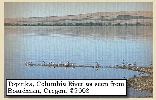
Between Irrigon and Boardman, today much of the banks on both sides of the Columbia along this reach are a part of the Umatilla National Wildlife Refuge.


Along the Journey - October 20, 1805
Columbia River from Boardman, part of the Umatilla NWR, 2003

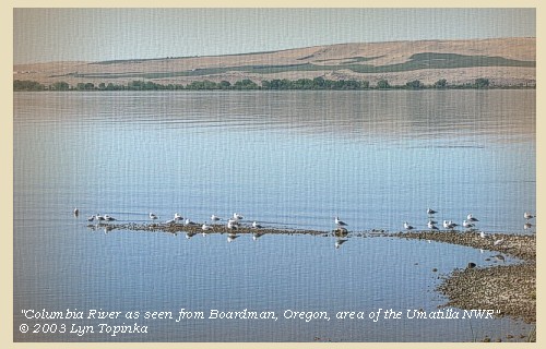
Umatilla National Wildlife Refuge:
Umatilla National Wildlife Refuge is 29,370 acres of marshes, sloughs, open water, cropland, and sagebrush uplands, and is a nesting area for Great Basin Canada geese and several species of ducks. The refuge typically has 90,000 wintering Canada geese and 200,000 wintering ducks - practically all species of ducks found in the west except sea ducks. The largest number of ducks on the refuge at one time was 458,000 on November 13, 1983. Long-billed curlews and other marsh and water birds nest on the refuge. Mammals include mule deer, coyote, and many smaller species. Walleye, steelhead, salmon, sturgeon, crappie, and bass are found in refuge waters. The refuge is located along the Columbia River in the vicinity of Irrigon, Oregon, and Paterson, Washington. -- U.S. Fish and Wildlife Service Website, 2002


NASA Image, 1985, Columbia River from Willow Creek to McNary Dam, click to enlarge NASA Image, 1985, Columbia River and the Umatilla National Wildlife Refuge, click to enlarge Image, 2003, Umatilla National Wildlife Refuge
  1. 1985, NASA Image, Columbia River from Willow Creek to McNary Dam (section of original) (Click to enlarge). View from space - Columbia River, Willow Creek, Alder Creek, Crow Butte, Umatilla National Wildlife Refuge vicinity, Umatilla River, McNary Dam, and Lake Umatilla, August, 1985. The Columbia River flows right (east) to left (west). Washington State is the upper half of the image (north) and Oregon is the lower half (south). Lake Umatilla was formed by the John Day dam (not in image). NASA Earth from Space #STS51F-035-0011. -- NASA Earth from Space Website, 2002
  2. 1985, NASA Image, Columbia River and the Umatilla National Wildlife Refuge vicinity (section of original) (Click to enlarge). View from space - Columbia River, Crow Butte, Lake Umatilla, and the Umatilla National Wildlife Refuge vicinity, August, 1985. The Columbia River flows right (east) to left (west). Washington State is the upper half of the image (north) and Oregon is the lower half (south). Lake Umatilla was formed by the John Day dam (not in image). NASA Earth from Space #STS51F-035-0011. -- NASA Earth from Space Website, 2002
  3. 2003, Columbia River from Boardman, Oregon, part of the Umatilla National Wildlife Refuge. (Click to enlarge). Copyright © 2003 Lyn Topinka, private archives, used with permission.


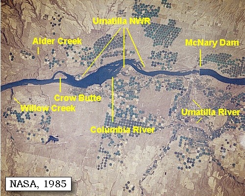
We passed three vacant houses near our camp, and at six miles reached the head of a rapid on descending which we soon came to another, very difficult and dangerous. It is formed by a chain of large black rocks, stretching from the right side of the river, and with several small islands on the left, nearly choaking the channel of the river. To this place we gave the name of the Pelican rapid [???], from seeing a number of pelicans and black cormorants about it. Just below it is a small island near the right shore, where are four houses of Indians, all busy in drying fish. [downstream of Patterson, Washington]
"... a chane of rocks makeing from the Stard. Side and nearly Chokeing the river up entirely with huge black rocks, ..." [Clark, October 20, 1805]
At sixteen miles from our camp we reached a bend to the left opposite to a large island, and at one o'clock halted for dinner on the lower point of an island on the right side of the channel. Close to this was a larger island on the same side, and on the left bank of the river a small one, a little below. [Blalock Islands area] We landed near some Indian huts, and counted on this cluster of three islands, seventeen of their houses filled with inhabitants, resembling in every respect those higher up the river; like the inhabitants, they were busy in preparing fish. ......


Along the Journey - October 20, 1805
Map, Blalock Islands area, 1858

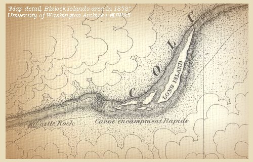
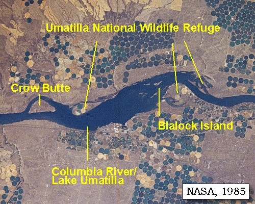
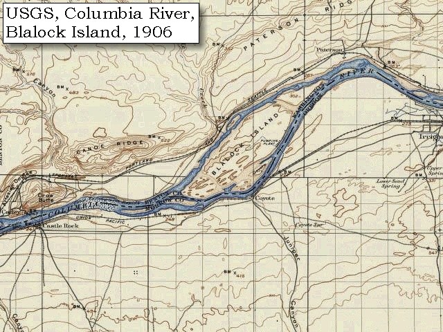
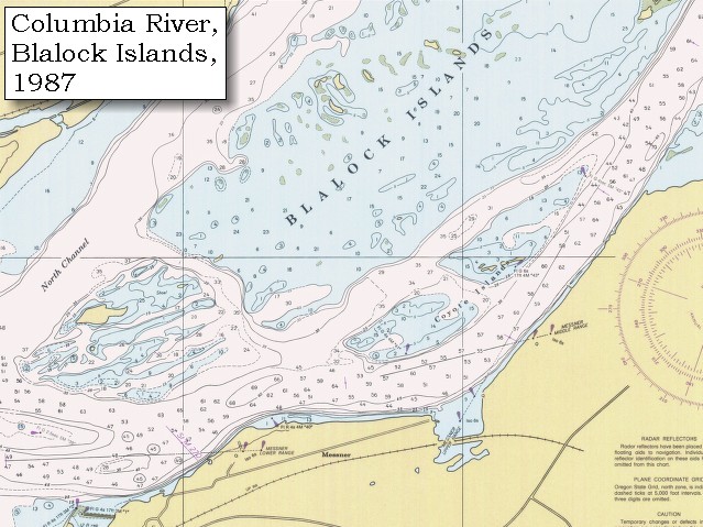
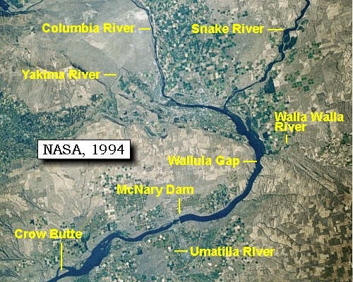
Blalock Islands:
The large island once known as "Long Island" and "Blalock Island" has been inundated with the waters of Lake Wallula, the reservoir behind McNary Dam.


Map, 1858 Military recon map, Castle Rock and Canoe Encampment Rapids, click to enlarge Map, 1906 USGS topo map, Blalock Islands, click to enlarge Map, 1987, Blalock Islands, downstream half, click to enlarge NASA Image, 1985, Columbia River from Willow Creek to McNary Dam, click to enlarge NASA Image, 1985, Columbia River and the Umatilla National Wildlife Refuge, click to enlarge
  1. 1858 Military Recon Map (section of original), Blalock Island Vicinity (Long Island). (Click to enlarge). Map of military reconnaissance from Fort Dalles, Oregon, via Fort Wallah-Wallah, to Fort Taylor, Washington Territory, 1858. Shows approximate location of military road constructed 1859 to 1862. From the report and maps of Captain John Mullan, United States Army, G.P.O., 1863. University of Washington Archives #UW85. -- University of Washington Library Archives Website, 2002
  2. 1906 Map Closer-View (section of original), from Blalock Island 1:125,000 topographic quadrangle. (Click to enlarge). Original map surveyed in 1906, contour interval of 50 feet. -- University of Washington Library Collections Website, 2002
  3. 1987 Map, Blalock Islands, downstream half (section of original). (Click to enlarge). Office of Coast Surveys, Historical Maps and Charts, Columbia River, Juniper to Pasco, 1987, Chart#18542, 1:20,000. -- NOAA Office of Coast Survey Website, 2004
  4. 1985, NASA Image, Columbia River from Willow Creek to McNary Dam (section of original) (Click to enlarge). View from space - Columbia River, Willow Creek, Alder Creek, Crow Butte, Umatilla National Wildlife Refuge vicinity, Umatilla River, McNary Dam, and Lake Umatilla, August, 1985. The Columbia River flows right (east) to left (west). Washington State is the upper half of the image (north) and Oregon is the lower half (south). Lake Umatilla was formed by the John Day dam (not in image). NASA Earth from Space #STS51F-035-0011. -- NASA Earth from Space Website, 2002
  5. 1985, NASA Image, Columbia River and the Umatilla National Wildlife Refuge, including Blalock Island (section of original) (Click to enlarge). View from space - Columbia River, Crow Butte, Blalock Island, and the Umatilla National Wildlife Refuge vicinity, August, 1985. The Columbia River flows right (east) to left (west). Washington State is the upper half of the image (north) and Oregon is the lower half (south). Lake Umatilla was formed by the John Day dam (not in image). NASA Earth from Space #STS51F-035-0011. -- NASA Earth from Space Website, 2002


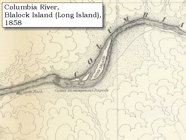
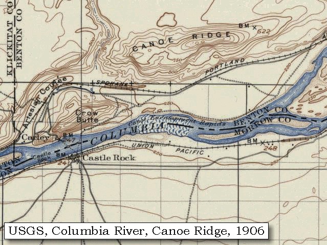
Half a mile beyond this, and at the distance of twenty-four from our camp, we came to the commencement of the highlands on the right [Canoe Ridge and Crow Butte area], which are the first we have seen on that side since near the Muscleshell rapids [Umatilla Rapids], leaving a valley forty miles in extent.


Along the Journey - October 20, 1805
Crow Butte in 1906 and 1994

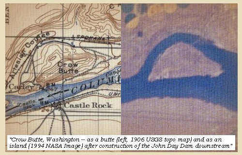
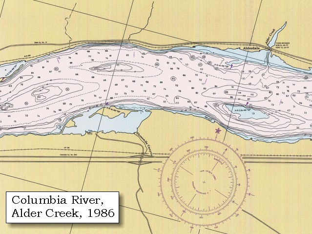
Crow Butte:
Prior to being an island, Crow Butte was a hill. In the 1970's, when John Day Dam was built and flooded the Columbia River, waters formed around Crow Butte, turning it into the island it is today. -- Washington State Parks and Recreation Website, 2002


Map, 1858 Military recon map, Castle Rock and Canoe Encampment Rapids, click to enlarge Map, 1906 USGS topo map of Canoe Ridge area, click to enlarge Map, 1986, Crow Butte, click to enlarge NASA Image, 1994, Columbia River from Crow Butte to the Snake River, click to enlarge NASA Image, 1985, Columbia River from Willow Creek to McNary Dam, click to enlarge NASA Image, 1985, Columbia River and the Umatilla National Wildlife Refuge, click to enlarge NASA Image, 1985, Columbia River and Crow Butte area, click to enlarge
  1. 1858 Military Recon Map (section of original), Blalock Island Vicinity (Long Island). (Click to enlarge). Map of military reconnaissance from Fort Dalles, Oregon, via Fort Wallah-Wallah, to Fort Taylor, Washington Territory, 1858. Shows approximate location of military road constructed 1859 to 1862. From the report and maps of Captain John Mullan, United States Army, G.P.O., 1863. University of Washington Archives #UW85. -- University of Washington Library Archives Website, 2002
  2. 1906 Map Closer-View (section of original), from Blalock Island 1:125,000 topographic quadrangle. (Click to enlarge). Original map surveyed in 1906, contour interval of 50 feet. -- University of Washington Library Collections Website, 2002
  3. 1986 Map, Crow Butte (section of original). (Click to enlarge). Office of Coast Surveys, Historical Maps and Charts, Columbia River, Alderdale to Blalock Islands, 1986, Chart#18537, 1:20,000. -- NOAA Office of Coast Survey Website, 2004
  4. 1994, NASA Image, Columbia River from Crow Butte to the Snake River (section of original) (Click to enlarge). View from space - Columbia River, Snake River, Yakima River, Walla Walla River, Umatilla River, Crow Butte and Wallula Gap, north-looking, low-oblique photograph, September 1994. NASA Earth from Space #STS064-112-093. -- NASA Earth from Space Website, 2002
  5. 1985, NASA Image, Columbia River from Willow Creek to McNary Dam (section of original) (Click to enlarge). View from space - Columbia River, Willow Creek, Alder Creek, Crow Butte, Umatilla National Wildlife Refuge vicinity, Umatilla River, McNary Dam, and Lake Umatilla, August, 1985. The Columbia River flows right (east) to left (west). Washington State is the upper half of the image (north) and Oregon is the lower half (south). Lake Umatilla was formed by the John Day dam (not in image). NASA Earth from Space #STS51F-035-0011. -- NASA Earth from Space Website, 2002
  6. 1985, NASA Image, Columbia River and the Umatilla National Wildlife Refuge, including Blalock Island (section of original) (Click to enlarge). View from space - Columbia River, Crow Butte, Blalock Island, and the Umatilla National Wildlife Refuge vicinity, August, 1985. The Columbia River flows right (east) to left (west). Washington State is the upper half of the image (north) and Oregon is the lower half (south). Lake Umatilla was formed by the John Day dam (not in image). NASA Earth from Space #STS51F-035-0011. -- NASA Earth from Space Website, 2002
  7. 1985, NASA Image, Columbia River and the Crow Butte vicinity (section of original) (Click to enlarge). View from space - Columbia River, Crow Butte, Lake Umatilla, Alder Creek, and Willow Creek, August, 1985. The Columbia River flows right (east) to left (west). Washington State is the upper half of the image (north) and Oregon is the lower half (south). Lake Umatilla was formed by the John Day dam (not in image). NASA Earth from Space #STS51F-035-0011. -- NASA Earth from Space Website, 2002


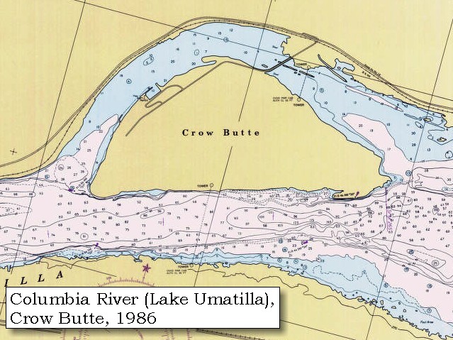
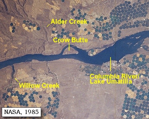
Crow Butte State Park:
Crow Butte State Park is a 1,312-acre camping park with 33,910 feet of freshwater shoreline (750 feet of unguarded beach) on the Columbia River, 13 miles west of Paterson, Washington. (NOTE: Washington State Parks closed Crow Butte Oct. 1, 2002. The park may be closed indefinitely to the public. The U.S. Army Corps of Engineers will determine the future of this park.) When homesteading began in the area in 1850, the Crow family was one of the first to come west. The site of their homestead is now under the waters of the nearby John Day Reservoir, but many of their descendents live in the vicinity. During a 1941 U.S. Army Corps of Engineers survey, the name "Crow Butte" was assigned to the area. The park officially opened in April, 1977. -- Washington State Parks and Recreation Website, 2002, 2004


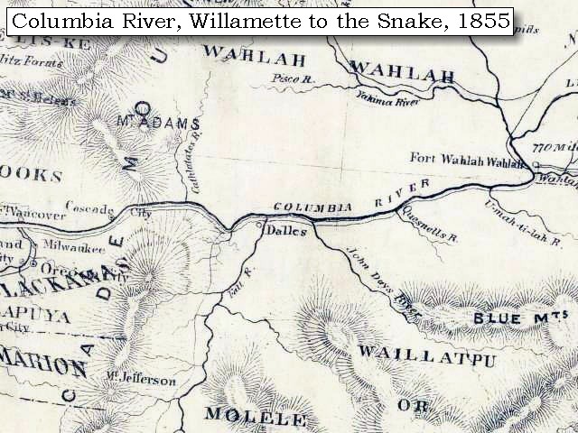
Having dined we proceeded past a small island, where were four huts of Indians, and at the lower extremity a bad rapid. Eight miles lower we passed a large island in the middle of the riverm below which are eleven small islands, five on the right, the same number on the left and one in the middle of the stream. A brook falls in on the right side [Alder Creek, Washingon], and a small rivulet empties itself behind one of the islands [Willow Creek, Oregon].
"... at 8 miles lower passed a large Island near the middle of the river a brook on the Stard. Side and 11 Islds. all in view of each other below, a riverlit falls in on the Lard. Side behind a Small Island a Small rapid below. ..." [Clark, October 20, 1805]


Along the Journey - October 20, 1805
USGS topo map detail, Alder Ridge and Alder Creek, 1906

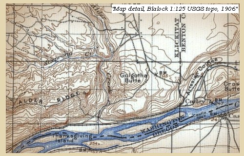
Alder Creek, Washington:
Alder Creek lies on the Washington State side of the Columbia River, at River Mile


Map, 1814, Lewis and Clark on the Columbia, click to enlarge Map, 1906 USGS topo map of Alder Creek and Alder Ridge area, click to enlarge Map, 1986, Alder Creek, Washington, click to enlarge NASA Image, 1985, Columbia River from Willow Creek to McNary Dam, click to enlarge NASA Image, 1985, Columbia River and Crow Butte area, click to enlarge
  1. 1814 Map, Lewis and Clark (section of original). (Click to enlarge.) Alder Creek is depicted but not named (left of the "You-ma-lolam R" on the north side of the Columbia). From the "Nicholas Biddle/Paul Allen" 1814 publication. Original Map: "A Map of Lewis and Clark's Track, Across the Western Portion of North America, From the Mississippi to the Pacific Ocean". From: History of the expedition under the command of Captains Lewis and Clark : to the sources of the Missouri, thence across the Rocky Mountains and down the river Columbia to the Pacific Ocean : performed during the years 1804-5-6 : by order of the government of the United States / prepared for the press by Paul Allen. Philadelphia : Bradford and Insskeep, 1814. Harold B. Lee Library, Brigham Young University #upbover maps37. -- Brigham Young University, Harold B. Lee Library Website, 2004.
  2. 1906 Map (section of original), from Blalock Island 1:125,000 topographic quadrangle. (Click to enlarge). Original map surveyed in 1906, contour interval of 50 feet. -- University of Washington Library Collections Website, 2002
  3. 1986 Map, Alder Creek, Washington (section of original). (Click to enlarge). Office of Coast Surveys, Historical Maps and Charts, Columbia River, Alderdale to Blalock Islands, 1986, Chart#18537, 1:20,000. -- NOAA Office of Coast Survey Website, 2004
  4. 1985, NASA Image, Columbia River from Willow Creek to McNary Dam (section of original) (Click to enlarge). View from space - Columbia River, Willow Creek, Alder Creek, Crow Butte, Umatilla National Wildlife Refuge vicinity, Umatilla River, McNary Dam, and Lake Umatilla, August, 1985. The Columbia River flows right (east) to left (west). Washington State is the upper half of the image (north) and Oregon is the lower half (south). Lake Umatilla was formed by the John Day dam (not in image). NASA Earth from Space #STS51F-035-0011. -- NASA Earth from Space Website, 2002
  5. 1985, NASA Image, Columbia River and the Crow Butte vicinity (section of original) (Click to enlarge). View from space - Columbia River, Crow Butte, Lake Umatilla, Alder Creek, and Willow Creek, August, 1985. The Columbia River flows right (east) to left (west). Washington State is the upper half of the image (north) and Oregon is the lower half (south). Lake Umatilla was formed by the John Day dam (not in image). NASA Earth from Space #STS51F-035-0011. -- NASA Earth from Space Website, 2002


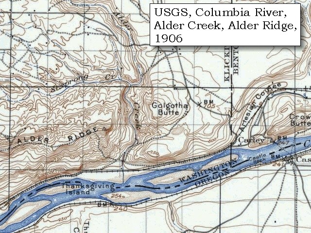
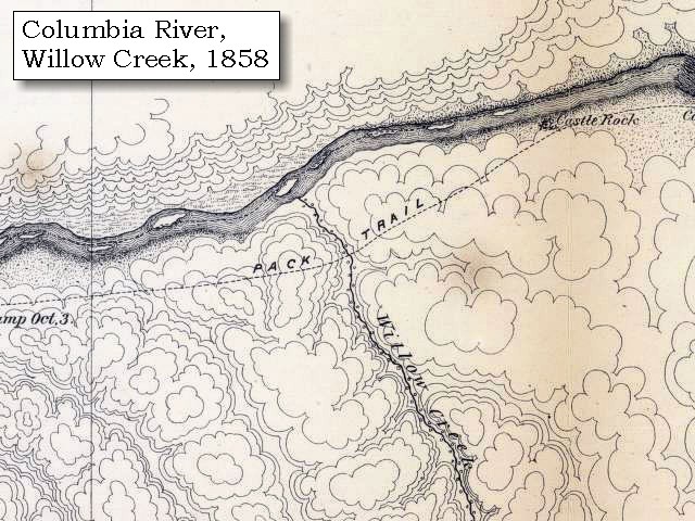
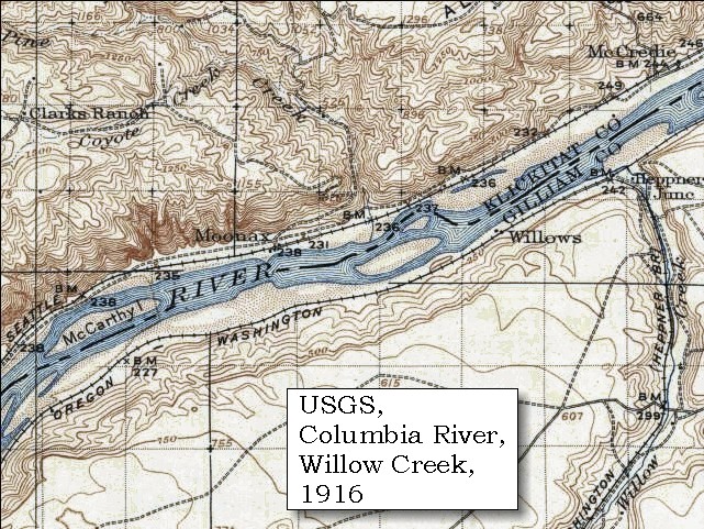
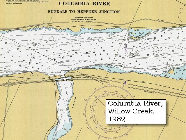
Willow Creek, Oregon:
Willow Creek is located on the Oregon side of the Columbia River, to the west of the Umatilla basin. It is a 79-mile long stream which drains into the Columbia River at River Mile 253. Willow Creek and its tributaries drain an area of about 880 square miles, ranging in elevation from 269 feet at its confluence with the Columbia River, to 5,583 feet at its headwaters near Bald Mountain in the Umatilla National Forest. -- Columbia Basin Fish and Wildlife Authority Website, 2002


Map, 1814, Lewis and Clark on the Columbia, click to enlarge Map, 1854, Columbia River, Willow Creek to Walla Walla, click to enlarge Map, 1855, Columbia River, Walla Walla to Vancouver, click to enlarge Map, 1858 Military recon map, Columbia River and mouth of Willow Creek, click to enlarge Map, 1916, USGS topo map section, Columbia River with Willow Creek, click to enlarge Map, 1982, Willow Creek, Oregon, click to enlarge NASA Image, 1985, Columbia River from Willow Creek to McNary Dam, click to enlarge NASA Image, 1985, Columbia River and Crow Butte area, click to enlarge
  1. 1814 Map, Lewis and Clark (section of original). (Click to enlarge.) Willow Creek is depicted but not named (left of the "You-ma-lolam R.", south side of the Columbia River). From the "Nicholas Biddle/Paul Allen" 1814 publication. Original Map: "A Map of Lewis and Clark's Track, Across the Western Portion of North America, From the Mississippi to the Pacific Ocean". From: History of the expedition under the command of Captains Lewis and Clark : to the sources of the Missouri, thence across the Rocky Mountains and down the river Columbia to the Pacific Ocean : performed during the years 1804-5-6 : by order of the government of the United States / prepared for the press by Paul Allen. Philadelphia : Bradford and Insskeep, 1814. Harold B. Lee Library, Brigham Young University #upbover maps37. -- Brigham Young University, Harold B. Lee Library Website, 2004.
  2. 1853-54 Map, Columbia River, including the Wallula Gap area (section of original). (Click to enlarge). Includes Horse Heaven Hills ("lands destitute of timber"), Willow Creek, Umatilla River, Walla Walla River, Touchet River, Twin Sisters ("Chimney Rock"), Yakima River, and the junction of the Snake River (only the "S" shows) with the Columbia. Original Map: "Rocky Mountains to Puget Sound : from explorations and surveys / made under the direction of the Hon. Jefferson Davis, Secretary of War by Isaac I. Stevens Governor of Washington Territory, 1853-4." Inset: (Supplementary sketch) Reconnaissance of the railroad route from Wallawalla to Seattle via Yak-e-mah River & Snoqualmie Pass. By A. W. Tinkham in January 1854. Drawn by J. R. P. Mechlin. 20 x 28 cm. Topographer, John Lambert, Published in Washington D.C., 1859, 1:1,200,000, Notes: From the U.S. War Department, Explorations and Surveys for a Railroad Route from the Mississippi River to the Pacific Ocean, Topographical Maps, to Illustrate the Various Reports, U.S. Library of Congress American Memories Reference "LC Railroad Maps #156". -- U.S. Library of Congress, American Memories Website, 2004
  3. 1855 Map, Columbia River, including Willow Creek (Quesnells R.) (section of original). (Click to enlarge). Original Map: "Map of Oregon and Washington Territories: showing the proposed Northern Railroad route to the Pacific Ocean, by John Disturnell, 1855. University of Washington Archives #UW155. -- University of Washington Library Collections Website, 2002
  4. 1858 Military Recon Map (section of original), Willow Creek. (Click to enlarge). Map of military reconnaissance from Fort Dalles, Oregon, via Fort Wallah-Wallah, to Fort Taylor, Washington Territory, 1858. Shows approximate location of military road constructed 1859 to 1862. From the report and maps of Captain John Mullan, United States Army, G.P.O., 1863. University of Washington Archives #UW85. -- University of Washington Library Archives Website, 2002
  5. 1916 Map (section of original), from Arlington 1:125,000 topographic quadrangle. (Click to enlarge). Original map surveyed in 1912-1913, contour interval of 50 feet. -- University of Washington Library Collections Website, 2002
  6. 1982 Map, Willow Creek, Oregon (section of original). (Click to enlarge). Office of Coast Surveys, Historical Maps and Charts, Columbia River, Sundale to Heppner Junction, 1982, Chart#18536, 1:20,000. -- NOAA Office of Coast Survey Website, 2004
  7. 1985, NASA Image, Columbia River from Willow Creek to McNary Dam (section of original) (Click to enlarge). View from space - Columbia River, Willow Creek, Alder Creek, Crow Butte, Umatilla National Wildlife Refuge vicinity, Umatilla River, McNary Dam, and Lake Umatilla, August, 1985. The Columbia River flows right (east) to left (west). Washington State is the upper half of the image (north) and Oregon is the lower half (south). Lake Umatilla was formed by the John Day dam (not in image). NASA Earth from Space #STS51F-035-0011. -- NASA Earth from Space Website, 2002
  8. 1985, NASA Image, Columbia River and the Crow Butte vicinity (section of original) (Click to enlarge). View from space - Columbia River, Crow Butte, Lake Umatilla, Alder Creek, and Willow Creek, August, 1985. The Columbia River flows right (east) to left (west). Washington State is the upper half of the image (north) and Oregon is the lower half (south). Lake Umatilla was formed by the John Day dam (not in image). NASA Earth from Space #STS51F-035-0011. -- NASA Earth from Space Website, 2002


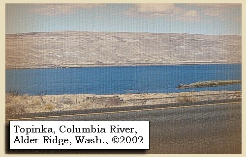
The country on the right consists of high and rugged hills; [Alder Ridge], the left is a low plain with no timber on either side, except a few small willow-brushes along the banks; though a few miles after leaving these islands the country on the left rises to the same height with that opposite to it, and becomes an undulating plain.


Along the Journey - October 20, 1805
Alder Ridge, Washington, 2002

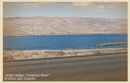
Alder Ridge:
Alder Ridge is located on the Washington State side of the Columbia River.


Map, 1906 USGS topo map of Alder Creek and Alder Ridge area, click to enlarge Image, 2002, Alder Ridge, Washington
  1. 1906 Map (section of original), from Blalock Island 1:125,000 topographic quadrangle. (Click to enlarge). Original map surveyed in 1906, contour interval of 50 feet. -- University of Washington Library Collections Website, 2002
  2. 2002, Alder Ridge, Washington, from across the Columbia River. (Click to enlarge). Copyright © 2002 Lyn Topinka, private archives, used with permission.


Two miles after passing a small rapid we reached a point of highland in a bend towards the right, and encamped for the evening [near today's Roosevelt, Washington, across from Arlington, Oregon], after a journey of forty-two miles. The river has been about a quarter of a mile in width, with a current much more uniform than it was during the last two days. We killed two speckled gulls, and several ducks of a delicious flavour.
"... this evening the Countrey on the Lard. Side rises to the hight of that on the Starboard Side, and is wavering ..." [Clark, October 20, 1805]


Along the Journey - October 20, 1805
Roosevelt, Washington, 2003

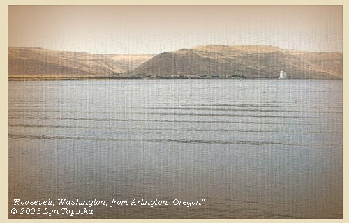
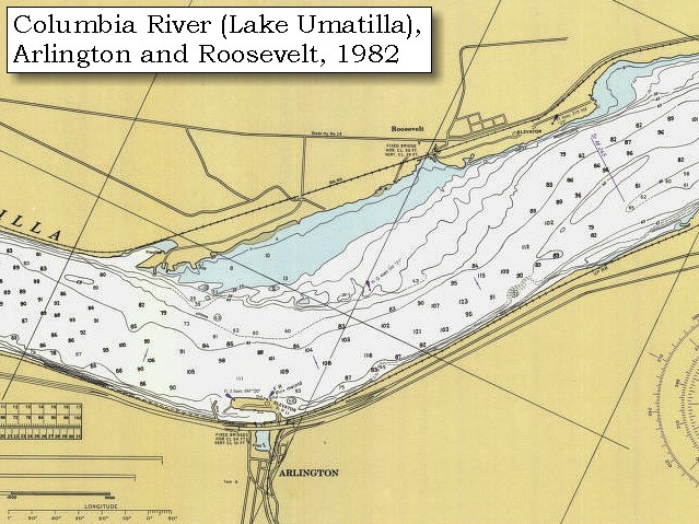
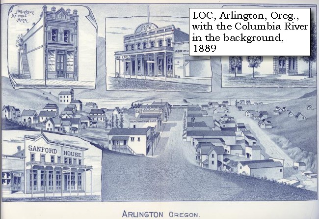
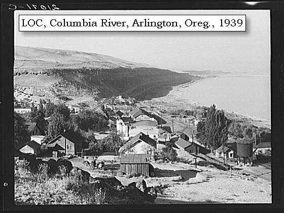
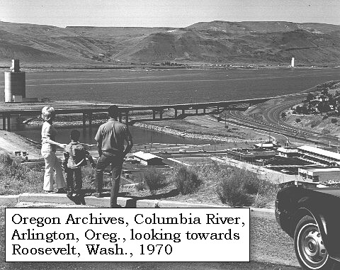
Arlington, Oregon, and Roosevelt, Washington:
Arlington, Oregon, was first settled in 1880, after the area was used through much of the previous decade as a meeting point where cattlemen would gather their cattle for sale. Originally named Alkali (after the Alkali Canyon, which it was located at the mouth of), the name was changed to Arlington in 1885 when the town was incorporated. The entire town of Arlington was relocated just uphill between 1953 and 1973, when the building of the John Day Dam drowned (on January 2nd, 1968) old Arlington for good. Directly across the Columbia River, on the Washington shore, is the town of Roosevelt. -- Washington State University Library Collections Website, 2002


Map, 1916, USGS topo map section, Columbia River with Arlington, Oregon and Roosevelt, Washington, click to enlarge Map, 1982, Columbia River with Arlington, Oregon and Roosevelt, Washington, click to enlarge Engraving, 1889, Arlington, Oregon, click to enlarge Image, 1939, Arlington, Oregon, click to enlarge Image, 1970, overlooking Arlington, Oregon, the Columbia River, and Roosevelt, Washington, click to enlarge Image, 2003, Roosevelt, Washington, from Arlington, Oregon
  1. 1916 Map (section of original), from Arlington 1:125,000 topographic quadrangle. (Click to enlarge). Original map surveyed in 1912-1913, contour interval of 50 feet. -- University of Washington Library Collections Website, 2002
  2. 1982 Map, Arlington, Oregon, and Roosevelt, Washington (section of original). (Click to enlarge). Office of Coast Surveys, Historical Maps and Charts, Columbia River, Sundale to Heppner Junction, 1982, Chart#18536, 1:20,000. -- NOAA Office of Coast Survey Website, 2004
  3. 1889 Engraving, Arlington, Oregon. (Click to enlarge). -- U.S. Library of Congress Website, 2002, American Memories
  4. 1939 Arlington, Oregon. (Click to enlarge). The town of Arlington, Oregon, on the Columbia River, 112 miles from Bonneville Dam. Photographer: Dorothea Lange. Photograph Date: October 1939. Library of Congress Archives #LC-USF34- 021071-C. -- U.S. Library of Congress Website, 2003, American Memories
  5. 1970, Overlooking Arlington, Oregon, the Columbia River, and Roosevelt, Washington. (Click to enlarge). This photo shows part of the small town of Arlington, located on U.S. Route I-84, on the Columbia River, 54 miles east of The Dalles. Arlington, at the junction of the John Day Highway and I-84 was relocated a short distance up the canyon as a result of the construction of The Dalles Dam and the newly created reservoir behind the dam. This picture, taken from an overlook of the town, shows the highway bridge, the new boat basin, a large grain elevator, the Columbia River, and the hills along the Washington State shore (location of Roosevelt, Washington), and another large grain elevator. Photograph Date: June 1970. Oregon State Archives Oregon Highway Division #OHD7441. -- Oregon State Archives Website, 2003
  6. 2003, Roosevelt, Washington, from Arlington, Oregon. (Click to enlarge). Copyright © 2003 Lyn Topinka, private archives, used with permission.


Along the Journey - October 20, 1805
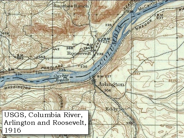
The Camp - October 20, 1805:
Lewis and Clark's camp of October 20, 1805 was on the Washington side of the Columbia River, near today's town of Roosevelt, across from today's town of Arlington, Oregon.


Home Previous Continue


If you have questions or comments please contact: GS-CVO-WEB@usgs.gov
June/July 2004, Lyn Topinka
The Volcanoes of Lewis and Clark Home Page | CVO Home Page