The Volcanoes of
Lewis and Clark
October 14 - 15, 1805
On the Snake River - Ayers Junction to Fish Hook Rapids
 
Home
The Volcanoes of Lewis and Clark

Map of the Journey
Volcanoes, Basalt Plateaus, Major Rivers, etc.

The Volcanoes
Mount Adams, Mount Hood, Mount Jefferson, Mount Rainier, and Mount St. Helens

CALENDAR of the Journey
October 1805 to June 1806

Along the Journey
Pacific Northwest Maps - Columbia River, Volcanoes, Flood Basalts, Missoula Floods, Geology, etc.

The Corps of Discovery
The Journey of Lewis and Clark

About the Reference Materials
The Journals, Biddle/Allen, DeVoto, Gass, Moulton, Topo Maps, and others

USGS Lewis and Clark Links
Links to USGS Websites highlighting the Lewis and Clark Journey

Resources
Publications Referenced and Websites Visited


PREVIOUS

October 13
On the Snake, Texas Rapids to Ayers Junction
October 14-15

On the Snake,
Ayers Junction to Fish Hook Rapids

Monumental Rock, Lower Monumental Dam and Lake West, Pine Tree Rapids, Blue Mountains, possible sighting of Mount Adams ???, Rattlesnake Flats and Fish Hook Rapids, Fishhook Park
CONTINUE

October 16
Reaching the Columbia, Snake/Columbia Confluence
 

On October 7, 1805, Lewis and Clark and the "Corps of Discovery" began their journey down the Clearwater River and into the volcanics of the Pacific Northwest. The Corps travelled from the Clearwater to the Snake and down the "Great Columbia", finally reaching the Pacific Ocean on November 15, 1805. Along the journey they encountered the lava flows of the Columbia Plateau, river channels carved by the great "Missoula Floods", and the awesome beauty of five Cascade Range volcanoes.

Map, Lewis and Clark in the Pacific Northwest, click for brief
                         summary
[Click map for brief summary about the area]


To the Pacific - October 1805
On the Snake - Ayers Junction to Fish Hook Rapids
 

Lewis and Clark's camp of October 13, 1805 was approximately 13 miles downstream of the Palouse River, on the north bank of the Snake River, 6 miles downstream of present-day Ayers Junction, Washington.

Monday, October 14, 1805
The wind was high from the southwest during the evening, and this morning it changed to the west, and the weather became very cold until about twelve o'clock, when it shifted to the southwest, and continued in that quarter during the rest of the day We set out early, and after passing some swift water, reached at two and a half miles It was situated on a point to the left, at some distance from the ascending country, very high and large, and resembling in its shape the hull of a ship. [Monumental Rock]
"... at 2 1/2 miles passed a remarkable rock verry large and resembling the hill of a Ship Situated on a Lard point at Some distance from the assending Countrey ..." [Clark, October 14, 1805]


Along the Journey - October 14, 1805
Monumental Rock:
Lewis and Clark called this large basalt rock formation "Ship Rock," because it resembled the hull of a ship. The Lewis and Clark name did not survive, replaced with a new name during the steamboat era on the Northwest rivers. Monumental Rock is located near the Monumental Rapids of the Snake River, and inspired the name for Lower Monumental Dam, one of the four dams on the lower section of the Snake River. -- Washington State Historical Society Website, 2002


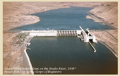
In 1969, construction was completed on the Lower Monumental Dam and Lock, spanning the Snake River at River Mile 42. Lake West, the reservoir behind Lower Monumental Dam, reaches nearly 30 miles upstream.


Along the Journey - October 14, 1805
Lower Monumental Dam

Lower Monumental Dam and Lake West:
The Lower Monumental Dam and Lock is the third of four dams on the Lower Snake River. Lower Monument Dam is located at River Mile 42, at the head of Lake Sacajawea, the reservoir created by Ice Harbor Dam. Construction of the project began in June 1961, and the project became operational in 1969. The Lower Monumental Dam is 3,791 feet long, with an effective height of 100 feet. The dam is a concrete gravity-type dam, with a short earthfill abutment embankments. The eight-bay spillway is 572 feet long, and has eight 50-foot by 60-foot tainter gates. The Lower Monumental Lock is a single-lift type. There are two fish ladders for passing migratory fish. Lake Herbert G. West, the reservoir behind the dam, extends up the Snake River for a distance of 28.1 miles to the tailwater of Little Goose Dam. The lake has a surface area of 6,590 acres, and is at elevation 540 feet. -- U.S. Army Corps of Engineers Website, 2002


Map, 1893, Snake River including Monumental and Pine Tree Rapids, click to enlarge NASA Image, 1994, Columbia River, with Snake River from Ice Harbor to Lower Monumental, click to enlarge Map, 1996, Recreation sites along Lake West including the Lower Monumental Dam, click to enlarge Aerial view, Lower Monumental Dam, click to enlarge
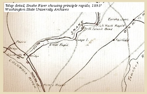
  1. 1893 Map, part of the Snake River showing location of principal rapids (section of original). Includes the Monumental Rapids and Pine Tree Rapids. (Click to enlarge). Original Map: "Part of the Snake River from its mouth to the Grande Ronde, showing location of principal rapids". U.S. Engineers Office, 1893. Washington State University Historical Maps Collection #WSU586. -- Washington State University Library Archives Website, 2002
  2. 1994, NASA Image, Columbia River and the Snake River from Ice Harbor Dam to Lower Monumental Dam (section of original) (Click to enlarge). View from space - Columbia River, Snake River, Ice Harbor Dam, and Lower Monumental Dam, north-looking, low-oblique photograph, September 1994. NASA Earth from Space #STS064-112-093. -- NASA Earth from Space Website, 2002
  3. 1996, Recreation sites along Lake West, including the Lower Monumental Dam (lower left). (Click to enlarge). Lake West is the reservoir behind the Lower Monumental Dam on the Snake River. -- U.S. Army Corps of Engineers Website, 2004, Walla Walla District
  4. Aerial view, Lower Monumental Dam on the lower Snake River. (Click to enlarge). U.S. Army Corps of Engineers Photograph #3996-13. Photograph Date: January 1995. Photographer: unknown From: U.S. Army Corps of Engineers Photo Library. -- U.S. Army Corps of Engineers Website, 2002


Prominent Lava Flows in the Vicinity:
The Saddle Mountains Basalt formation is the youngest in the Columbia River Basalt Group. It is about 13.5 to 6 million years old and contains flows erupted sporadically during a period of waning volcanism, deformation, canyon cutting, and development of thick but local sedimentary deposits between flows. The Saddle Mountains Basalt has a volume of only about 700 cubic miles, less than one percent of the total volume of basalt, yet contains by far the greatest chemical and isotopic diversity of any formation in the group. The Lower Monumental Member, about 6 million years old, is the youngest member in the Saddle Mountains Basalt. It is confined to the modern Snake River Canyon between Devils Canyon and Asotin, Washington, a distance of about 95 miles. Its source was presumably near Asotin, Washington, or farther east but has not yet been identified. Near the Lower Monumental Dam, the Lower Monumental Member forms cliffs overlying river gravels. -- Swanson and Wright, 1981


At five miles we passed a rapid; at eight another rapid, and a small island on the right, and at ten and a half a small island on the right. We halted a mile and a half below for the purpose of examining a much larger and more dangerous rapid than those we had yet passed. It is three miles in length, and very difficult to navigate. We had scarcely set out, when three of the canoes stuck fast in endeavouring to avoid the rocks in the channel; soon after in passing two small rocky islands, one of the canoes struck a rock, but was prevented from upsetting, and fortunately we all arrived safe at the lower end of the rapid. Here we dined, and then proceeded, and soon reached another rapid [Pine Tree Rapids] on both sides of the river, which was divided by an island.


Along the Journey - October 14, 1805
Pine Tree Rapids:
Pine Tree Rapids are just downstream from Burr Canyon, and now are covered by Lake Sacajawea, the reservoir behind Ice Harbor Dam.


Map, 1893, Snake River including Monumental and Pine Tree Rapids, click to enlarge NASA Image, 1994, Aerial view Columbia River, with Snake River from Ice Harbor to Lower Monumental, click to enlarge
  1. 1893 Map, part of the Snake River showing location of principal rapids (section of original). Includes the Monumental Rapids and Pine Tree Rapids. (Click to enlarge). Original Map: "Part of the Snake River from its mouth to the Grande Ronde, showing location of principal rapids". U.S. Engineers Office, 1893. Washington State University Historical Maps Collection #WSU586. -- Washington State University Library Archives Website, 2002
  2. 1994, NASA Image, Columbia River and the Snake River from Ice Harbor Dam to Lower Monumental Dam (section of original) (Click to enlarge). View from space - Columbia River, Snake River, Ice Harbor Dam, and Lower Monumental Dam, north-looking, low-oblique photograph, September 1994. NASA Earth from Space #STS064-112-093. -- NASA Earth from Space Website, 2002


As we were descending it one of the boats was driven crosswise against a rock in the middle of the current. The crew attempted to get her off, but the waves dashed over her, and she soon filled; they got out on the rock and held her above water with great exertion, till another canoe was unloaded and sent to her relief; but they could not prevent a great deal of her baggage from floating down the stream. ...... In order to diminish the loss as far as was in our power, we halted for the night on an island [at Pine Tree Rapids], and exposed every thing to dry. ...... Our journey was fifteen miles in length.
"... the country continues barron and broken in places &C ..." [Ordway, October 14, 1805]


Along the Journey - October 14, 1805
The Camp - October 14, 1805:
Lewis and Clark's camp of October 14, 1805, was on an island at the Pine Tree Rapids, just downstream from Burr Canyon. It is now inundated by Lake Sacajawea, the reservoir behind Ice Harbor Dam.


Tuesday, October 15, 1805
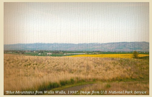
The morning was fair, and being obliged to remain for the purpose of drying the baggage, we sent out the hunters to the plains, but they returned at ten o'clock, without having seen even the tracks of any large game, but brought in three geese and two ducks. The plains are waving, and as we walked in them, we could plainly discover a range of mountains [Blue Mountains] bearing southeast and northwest, becoming higher as they advanced towards the north, the nearest point bearing south about sixty miles from us.
"... a fair morning after a Cold night. Some frost this morning and Ice. Several hunters out Saw nothing     Capt Lewis assended the hills & Saw Mountain a head bearing S. E. & N W.     a high point to the west.     Plain wavering. Set out at 3 oClock? ..." [Clark, October 15, 1805, first draft]

The "Mountain a head bearing S. E. & N W." are the Blue Mountains. However, could this "a high point to the west" be Mount Adams ??? ... Some Historians believe so, making this the earliest sighting Lewis and Clark had of the Cascade Range Volcanoes.


Along the Journey - October 15, 1805
Blue Mountains, 1998

Blue Mountains:
The topography of the Blue Mountains consists of flat-topped ridges and steep stair-stepped valley walls formed by thousands of feet of Miocene basalt flows that engulfed the folded, faulted, and uplifted granitic core of the mountains. As mountains were uplifted, streams and glaciers carved canyons through the basalt layers. -- Columbia Basin Fish and Wildlife Authority Website, 2004


Map, 1814, Lewis and Clark on the Snake River, click to enlarge Map, 1855, Clearwater and Snake from Canoe Camp to the Columbia, click to enlarge Map, 1881, Snake, Clearwater, Grande Ronde, Salmon, click to enlarge Engraving, 1876, 'Birds eye view' of Walla Walla and the Blue Mountains, click to enlarge Image, 1998, Blue Mountains, click to enlarge
  1. 1814 Map, Lewis and Clark (section of original). (Click to enlarge.) The Blue Mountains are depicted but not named (lower half left). From the "Nicholas Biddle/Paul Allen" 1814 publication. Original Map: "A Map of Lewis and Clark's Track, Across the Western Portion of North America, From the Mississippi to the Pacific Ocean". From: History of the expedition under the command of Captains Lewis and Clark : to the sources of the Missouri, thence across the Rocky Mountains and down the river Columbia to the Pacific Ocean : performed during the years 1804-5-6 : by order of the government of the United States / prepared for the press by Paul Allen. Philadelphia : Bradford and Insskeep, 1814. Harold B. Lee Library, Brigham Young University #upbover maps37. -- Brigham Young University, Harold B. Lee Library Website, 2004.
  2. 1855 Map, Clearwater and Snake Rivers, including the Blue Mountains (section of original). (Click to enlarge). Original Map: "Map of Oregon and Washington Territories: showing the proposed Northern Railroad route to the Pacific Ocean, by John Disturnell, 1855. University of Washington Archives #UW155. -- University of Washington Library Collections Website, 2002
  3. 1881 Map, Snake, Clearwater, Grande Ronde, and Salmon Rivers (section of original). (Click to enlarge). Original Map: "Map of the Grande Ronde Wallowa and Imnaha Country, 1881". Map section shows the Snake River (name doesn't show), "Clear Water" River (central right, tributary to the Snake), Grande Ronde River (lower left, only "de River" shows, tributary to the Snake), Salmon River (lower right, tributary to the Snake) Lewiston, Central Ferry, Alpowai, Dayton, Pataha, and the Blue Mountains. By H. Chandler, Eng., Buffalo, 1881., Washington State University Historical Maps Collection #WSU468. -- Washington State University Library Archives Website, 2002
  4. 1876 Engraving, "Birds eye view" of Walla Walla, Washington Territory, with the Blue Mountains 9 miles distant. (Click to enlarge). Drawn by E.S. Glover. A.L. Bancroft & Co., lithographers. Perspective map not drawn to scale. "From the west, looking east." Includes index to points of interest and text. -- U.S. Library of Congress, American Memories Website, 2002
  5. 1998, Blue Mountains (Click to enlarge). U.S. National Park Service, Whitman National Monument, #cmb-1998-12. -- U.S. National Park Service Website, 2004


Our stores being sufficiently dry to be reloaded, and as we shall be obliged to stop for the purpose of making some celestial observations at the mouth of the river [Snake River], which cannot be at a great distance, we concluded to embark and complete the drying at that place: we therefore set out at two o'clock.
" ... This river in general is very handsome, except at the rapids, where it is risking both life and property to pass; and even these rapids, when the bare view or prospect is considered distinct from the advantages of navigation, may add to its beauty, by interposing variety and scenes of romantick grandeur where there is so much uniformity in the appearance of the country ..." [Gass, October 15, 1805]
For the first four miles we passed three islands, at the lower points of which were the same number of rapids, besides a fourth at a distance from them. During the next ten miles we passed eight islands and three more rapids, and reached a point of rocks on the left side. The islands were of various sizes, but were all composed of round stone and sand: the rapids were in many places difficult and dangerous to pass. About this place the country becomes lower than usual, the ground over the river not being higher than ninety or a hundred feet, and extending back into a waving plain. Soon after leaving this point of rocks, we entered a narrow channel formed by the projecting cliffs of the bank, which rise nearly perpendicular from the water. The river is not however rapid, but gentle and smooth during its confinement, which lasts for three miles, when it falls, or rather widens into a kind of basin nearly round, and without any perceptible current.
"... in the evening the countrey becomes lower not exceding 90 or 100 feet above the water and back is a wavering Plain on each Side, passed thro: narrows for 3 miles where the Clifts of rocks juted to the river on each Side compressing the water of the river through a narrow chanel; below which it widens into a kind of bason nearly round without any proceptiable current, at the lower part of this bason is a bad dificuelt and dangerous rapid to pass ..." [Clark, October 15, 1805]
"... Clifts of rocks 100 feet high. below which the river widens into a Bay nearly round. ..." [Clark, October 15, 1805]
After passing through this basin, we were joined by the three Indians who had piloted us through the rapids since we left the forks, and who in company with our two chiefs had gone before us. They had now halted here to warn us of a dangerous rapid [Fishhook Rapids], which begins at the lower point of the basin. As the day was too far spent to descend it, we determined to examine before we attempted it, and therefore landed near an island at the head of the rapid [Fishhook Rapids], and studied particularly all its narrow and difficult parts. The spot where we landed [Rattlesnake Flats, across from today's Fishhook Park] was an old fishing establishment, of which there yet remained the timbers of a house carefully raised on scaffolds to protect them against the spring tide.


Along the Journey - October 15, 1805
Map, Fish Hook Rapids, 1893

Rattlesnake Flats and Fish Hook Rapids:
Rattlesnake Flats is located on the right bank of the Snake River at the head of Fish Hook Rapids, across from today's Fishhook Park. Fish Hook Rapids today is under the waters of Lake Sacajawea. In 1959, two prehistoric pit-house village archaeological sites were found here. -- Washington State Chapter Lewis & Clark Heritage Foundation Website, 2004, March 1999 Newsletter, and Tourism Walla Walla Website, 2004.


Map, 1893, Snake River showing Fishhook Rapids, click to enlarge NASA Image, 1994, Columbia River, with Snake River from Ice Harbor to Lower Monumental, click to enlarge
  1. 1893 Map, part of the Snake River showing location of principal rapids (section of original). Includes Fishhook Rapids. (Click to enlarge). Original Map: "Part of the Snake River from its mouth to the Grande Ronde, showing location of principal rapids". U.S. Engineers Office, 1893. Washington State University Historical Maps Collection #WSU586. -- Washington State University Library Archives Website, 2002
  2. 1994, NASA Image, Columbia River and the Snake River from Ice Harbor Dam to Lower Monumental Dam (section of original) (Click to enlarge). View from space - Columbia River, Snake River, Ice Harbor Dam, and Lower Monumental Dam, north-looking, low-oblique photograph, September 1994. NASA Earth from Space #STS064-112-093. -- NASA Earth from Space Website, 2002


Fishhook Park:
Fishhook Park is a U.S. Corps of Engineers Park located on the south bank of Lake Sacajawea at Snake River Mile 18. The park is located 18 miles east of Burbank, Washington, on Highway 124, and 4 miles north on Fishhook Park Road. -- U.S. Army Corps of Engineers Website, 2003


Not being able to procure any other fuel, and the night being cold, we were again obliged to use the property of the Indians, who still remain in the plains hunting the antelope. Our progress was only twenty miles in consequence of the difficulty of passing the rapids. Our game consisted of two teal.
"... the country continues barron as usal. ..." [Ordway, October 15, 1805]


Along the Journey - October 15, 1805
The Camp - October 15, 1805:
Lewis and Clark's camp of October 15, 1805 was located at Rattlesnake Flats, on the right bank of the Snake River at the head of Fishhook Rapids. Fishhook Rapids today is under the waters of Lake Sacajawea. The camp was located directly across the Snake River from today's Fishhook Park.


Home Previous Continue


If you have questions or comments please contact: GS-CVO-WEB@usgs.gov
June/July 2004, Lyn Topinka
The Volcanoes of Lewis and Clark Home Page | CVO Home Page