The Volcanoes of
Lewis and Clark
Lewis and Clark
|
October 12, 1805 On the Snake River - Almota Creek to Texas Rapids |
|
Home
The Volcanoes of Lewis and Clark Map of the Journey Volcanoes, Basalt Plateaus, Major Rivers, etc. The Volcanoes Mount Adams, Mount Hood, Mount Jefferson, Mount Rainier, and Mount St. Helens CALENDAR of the Journey October 1805 to June 1806 Along the Journey Pacific Northwest Maps - Columbia River, Volcanoes, Flood Basalts, Missoula Floods, Geology, etc. The Corps of Discovery The Journey of Lewis and Clark About the Reference Materials The Journals, Biddle/Allen, DeVoto, Gass, Moulton, Topo Maps, and others USGS Lewis and Clark Links Links to USGS Websites highlighting the Lewis and Clark Journey Resources Publications Referenced and Websites Visited |
PREVIOUS
October 11 On the Snake, Clearwater Confluence to Almota Creek |
October 12
On the Snake, Almota Creek to Texas Rapids Penawawa Creek, Central Ferry State Park, Deadman Creek Watershed, Little Goose Dam and Lake Bryan, Alakali Flat Creek, Riparia and Texas City (Washington), and the Texas Rapids |
CONTINUE
October 13 On the Snake, Texas Rapids to Ayers Junction |
|
To the Pacific - October 1805
On the Snake River - Almota Creek to Texas Rapid |
| Lewis and Clark's camp of October 11, 1805, was located near the mouth of Almota Creek, approximately 4 miles downstream of the Lower Granite Dam. |
| Monday, October 12, 1805 |
| In the morning it shifted to the east, and we had a fair cool morning. After purchasing all the provisions these Indians would spare, which amounted to only three dogs and a few fish, we proceeded. We soon reached a small island, and in the course of three miles passed three other islands nearly opposite to each other, and a bad rapid on the left in the neighbourhood of them. Within the following seven miles we passed a small rapid, and an island on the left, another stony island and a rapid on the right, just below which a brook comes in on the same side, [Penawawa Creek] and came to a bend towards the right opposite to a small island. From this place we saw some Indians on the hills, but they were too far off for us to have any intercourse, and showed no disposition to approach us. |
|
|
|
Penawawa Creek:
Streams draining the north side of the Snake River include Alkali Flat Creek, Penawawa, Almota, Wawawai and Steptoe Canyon creeks, and those draining the south include the Alpowa, Deadman, and Meadow creeks. Little is known about most of these streams, but there is a recent effort by several agencies to sample fish populations and habitat conditions in them. These tributaries generally drain an arid landscape and they have similar climate and land use. -- Columbia Fish and Wildlife Authority Website, 2003, and Washington State Department of Ecology Website, 2004 |
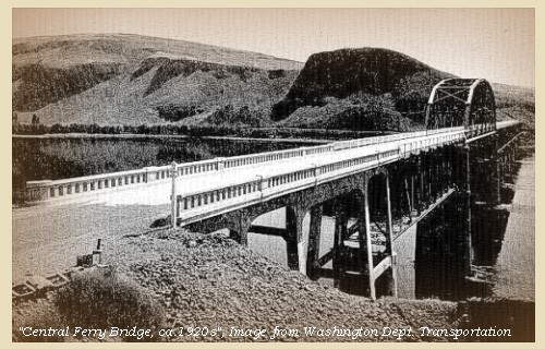
| After going on two miles to a bend towards the left, we found the plains, which till now had formed rugged cliffs over the river, leaving small and narrow bottoms, become much lower on both sides, and the river itself widens to the space of four hundred yards, and continues for the same width, the country rising by a gentle ascent towards the high plains. At two and a half miles is a small creek on the left [Deadman Creek, today the location of Central Ferry State Park], opposite to an island. |
| For the three following miles, the country is low and open on both sides, after which it gradually rises till we reached a bend of the river towards the right, three and a half miles further, in the course of which we passed a rapid and an island. |
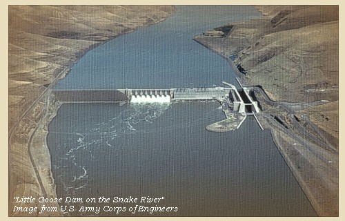
| Little Goose Dam and Navigational Lock is now located in this area, with Lake Bryan, the reservoir behind the dam, extending nearly 38 miles up the Snake River. |
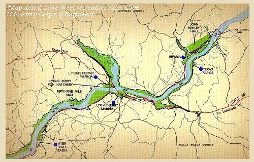
| The wind now changed to the southwest,and became violent. We passed an island at the distance of four miles, another one mile beyond it, where the water was swift and shallow, and two miles further, a rapid at the upper point of a small stony island. We went along this island by the mouth of a brook on the right [Alkali Flat Creek], and encamped on the same side opposite to a small island close under the left shore [near Riparia, Washington]. Our day's journey had been thirty miles, and we might have gone still further, but as the evening was coming on we halted at the head of a rapid, which the Indians represented as dangerous to pass [Texas Rapids], for the purpose of examining it before we set out in the morning. |
| The country has much the same appearance as that we passed yesterday, consisting of open plains, which when they approach the water are faced with a dark-coloured rugged stone. The river is as usual much obstructed by islands and rapids, some of which are difficult to pass. Neither the plains nor the borders of the river possess any timber, except a few hackberry bushes and willows, and as there is not much driftwood, fuel is very scarce. |
| "... Country as yesterday open plains, no timber of any king ... The hills or assents from the water is faced with a dark ruged Stone ..." [Clark, October 12, 1805] |
|
|
|
The Camp - October 12, 1805
Lewis and Clark's camp of October 12, 1805, was at the mouth of Alkali Flat Creek, near the town of Riparia, Washington, just west of Little Goose Dam. The campsite was at the head of Texas Rapids which is now below the backwater of Lower Monumental Dam. |
| Home | Previous | Continue |
If you have questions or comments please contact: GS-CVO-WEB@usgs.gov
June/July 2004, Lyn Topinka
The Volcanoes of Lewis and Clark Home Page | CVO Home Page


