Lewis and Clark
|
October 10, 1805 Reaching the Snake - Clearwater Confluence with the Snake River |
|
Home
The Volcanoes of Lewis and Clark Map of the Journey Volcanoes, Basalt Plateaus, Major Rivers, etc. The Volcanoes Mount Adams, Mount Hood, Mount Jefferson, Mount Rainier, and Mount St. Helens CALENDAR of the Journey October 1805 to June 1806 Along the Journey Pacific Northwest Maps - Columbia River, Volcanoes, Flood Basalts, Missoula Floods, Geology, etc. The Corps of Discovery The Journey of Lewis and Clark About the Reference Materials The Journals, Biddle/Allen, DeVoto, Gass, Moulton, Topo Maps, and others USGS Lewis and Clark Links Links to USGS Websites highlighting the Lewis and Clark Journey Resources Publications Referenced and Websites Visited |
PREVIOUS
October 7-9 On the Clearwater, Canoe Camp to the Potlatch River |
October 10
Reaching the Snake, Clearwater Confluence with the Snake River Potlatch River, Lapwai Creek and Spalding (Idaho), Junction of the Clearwater with the Snake, Lewiston (Idaho) and Clarkston (Washington), Nez Perce National Historic Park, Clearwater River, and the Snake River |
CONTINUE
October 11 On the Snake River, Clearwater Confluence to Almota Creek |
|
To the Pacific - October 1805
Reaching the Snake -- Clearwater Confluence with the Snake |
| Lewis and Clark's camp of October 8 and 9, 1805, was on the Clearwater River, a mile and 1/2 downsteam from the Potlatch River. |
| Thursday, October 10, 1805 |
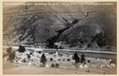
| A fine morning. We loaded the canoes and set off at seven o'clock. At the distance of two and a half miles we had passed three islands, the last of which is opposite to a small stream on the right [Catholic Creek]. Within the following three and a half miles is another island and a creek on the left [Lapwai Creek, site of today's Spalding, Idaho], with wide low grounds, containing willow and cottonwood trees, on which were three tents of Indians. |
| Two miles lower is the head of a large island [Hog Island], and six and a half miles further we halted at an encampment of eight lodges on the left, in order to view a rapid before us [called "Ragid rapid" by Lewis and Clark, today's Reubens Rapid]: we had already passed eight, and some of them difficult; but this was worse than any of them, being a very hazardous ripple strewed with rocks: we here purchased roots and dined with the Indians. ...... After finishing our meal we descended the rapid with no injury, except to one of our boats which ran against a rock, but in the course of an hour was brought off with only a small split in her side. This ripple, from its appearance and difficulty, we named the Rugged rapid [Reubens Rapid]. |
| "... at this riffle which we Call ragid rapid took meridian altitude of the Suns upper Limb with Sextt. 74o 26' 0" Latd. ... " [Clark, October 10, 1805] |
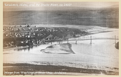
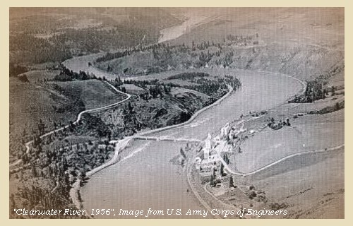
| We went on over five other rapids of a less dangerous kind, and at the distance of five miles reached a large fork of the river from the south [Snake River]; and after coming twenty miles, halted below the junction on the right side of the river [across from today's Lewiston, Idaho, and Clarkston, Washington]. ...... |
| The country at the junction of the two rivers [The Clearwater and the Snake] is an open plain on all sides, broken towards the left by a distant ridge of highland, thinly covered with timber [Craig Mountains]: this is the only body of timber which the country possesses; for at the forks there is not a tree to be seen, and during almost the whole descent of sixty miles down the Kooskooskee [Clearwater River] from its forks there are very few. |
| "... The Countrey about the forks is an open Plain on either Side I can observe at a distance on the lower Stard. Side a high ridge of Thinly timbered Countrey the water of the South fork is a greenish blue, the north as clear as cristial ... " [Clark, October 10, 1805] |
|
This southern branch is in fact the main
stream of
Lewis's river
[Snake River]
on which we encamped when among the Shoshonees.
The Indians inform us that it is
navigable for sixty miles;
that not far from its mouth it receives a
branch from the south
[possibly the Grande Ronde ???];
and a second and larger branch,
two days' march up, and nearly parallel to
the first Chopunnish villages,
we met near the mountains.
This branch is called
Pawnashte
[possibly the Salmon ???],
and is the residence of a chief, who, according to their
expression, has more horses than he can count.
The river has many rapids, near which are situated many
fishing camps.
......
At its mouth Lewis's river [Snake River] is about two hundred and fifty yards wide, and its water is of a greenish blue colour. The Kooskooskee [Clearwater River], whose waters are clear as crystal, one hundred and fifty yards in width, and after the union the river enlarges to the space of three hundred yards: at the point of the union is an Indian cabin, and in Lewis's river [Snake River] a small island [Hirzel Island]. ...... |
|
The soil of these prairies is of a light yellow clay intermixed with smooth grass: it is barren, and produces little more than a bearded grass about three inches high, and a prickly pear, of which we now found three species ...... |
| "... worthey of remark that not one Stick of timber on the river near the forks and but a fiew trees for a great distance up the River we decended I think Lewis's River is about 250 yards wide, the 'Koos koos ke' River about 150 yeards wide and the river below the forks about 300 yards wide ..." [Clark, October 10, 1805] |
|
|
|
The Camp - October 10, 1805:
Lewis and Clark's camp of October 10, 1805, was on the north bank at the confluence of the Clearwater and Snake Rivers, where today, the "twin" cities of Lewiston, Idaho, and Clarkston, Washington, are located. The camp was on the Washington/Idaho border. |
| Home | Previous | Continue |
If you have questions or comments please contact: GS-CVO-WEB@usgs.gov
June/July 2004, Lyn Topinka
The Volcanoes of Lewis and Clark Home Page | CVO Home Page


