The Volcanoes of
Lewis and Clark
Lewis and Clark
|
October 7 - 9, 1805 On the Clearwater - Canoe Camp to the Potlatch River |
|
Home
The Volcanoes of Lewis and Clark Map of the Journey Volcanoes, Basalt Plateaus, Major Rivers, etc. The Volcanoes Mount Adams, Mount Hood, Mount Jefferson, Mount Rainier, and Mount St. Helens CALENDAR of the Journey October 1805 to June 1806 Along the Journey Pacific Northwest Maps - Columbia River, Volcanoes, Flood Basalts, Missoula Floods, Geology, etc. The Corps of Discovery The Journey of Lewis and Clark About the Reference Materials The Journals, Biddle/Allen, DeVoto, Gass, Moulton, Topo Maps, and others USGS Lewis and Clark Links Links to USGS Websites highlighting the Lewis and Clark Journey Resources Publications Referenced and Websites Visited |
PREVIOUS
October 5-6 The Journey Begins, Canoe Camp |
October 7-9
On the Clearwater, Canoe Camp to the Potlatch River Canoe Camp, Clearwater River, Big Canyon Creek, Jack's Creek, and the Potlatch River |
CONTINUE
October 10 Reaching the Snake River, Clearwater Confluence with the Snake River |
|
To the Pacific - October 1805
On the Clearwater -- Canoe Camp to Jacks Creek |
| Between September 26 and October 7, 1805, Lewis and Clark camped at the confluence of the North Fork Clearwater River with the main stem Clearwater River, approximately 4 miles west of today's Orofino, Idaho. This site is called "Canoe Camp". |
| Monday, October 7, 1805 |
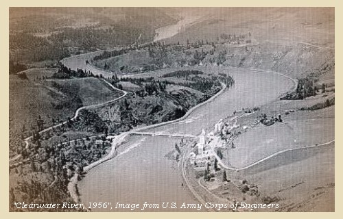
| This morning all the canoes were put in the water and loaded, the oars fixed, and every preparation made for setting out but when we were all ready, the two chiefs who had promised to accompany us, were not to be found, and at the same time we missed a pipe tomahawk. We therefore proceeded without them. Below the forks [confluence North Fork Clearwater River with the main stem Clearwater] this river is called the Kooskooskee [Clearwater River], and is a clear rapid stream, with a number of shoals and difficult places. |
| For some miles the hills are steep, the low grounds narrow, but then succeeds an open country with a few trees scattered along the river. At the distance of nine miles is a small creek on the left [Big Canyon Creek, near Peck, Idaho]. |
|
|
|
Big Canyon Creek:
Big Canyon Creek is approximately 30 miles in length and flows in a northerly direction before discharging into the Clearwater River at River Mile 42.5. -- Bonneville Power Administration Website, 2004 |
| We passed in the course of the day ten rapids, in descending which, one of the canoes struck a rock, and sprung a leak: we however continued for nineteen miles, and encamped on the left side [error in this Biddle publication as camp was on the right side. Jacks Creek is on the left and they camped "opposite". Quoted passage below (from Moulton, Vol.6) confirms.] of the river opposite to the mouth of a small run [Jack's Creek, on the left side of the river, near the town of Lenore, Idaho] |
|
|
|
Jacks Creek:
Jacks Creek is approximately 8 miles in length and courses in a northerly direction through a canyon area, has well developed riparian vegetation, and discharges into the Clearwater River at River Mile 36. Lewis and Clark refer to this creek as "Canister run", so named for the location the men stored canisters of gunpowder in 1805 for their return journey east in 1806. -- Bonneville Power Administration Website, 2004, and Clearwater Historical Society Website, 2002 |
| Here the canoe was unloaded and repaired, and two lead canisters of powder deposited; several camps of Indians were on the sides of the river, but we had little intercourse with any of them. |
| "... The hills come close on the river on both sides; where there are a few pine trees. Back from the river the tops of the hills, to a great distance are prairie land; and the country level. ..." [Gass, October 7, 1805] |
|
|
|
The Camp - October 7, 1805:
Near the present town of Lenore, across the river from Jacks Creek. |
| Tuesday, October 8, 1805 |
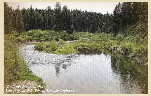
| We set out at nine o'clock [from Jacks Creek]. At eight and a half miles we passed an island [Fir Island]: four and a half miles lower a second island [Upper Cottonwood Island], opposite a small creek on the left side of the river [Cottonwood Creek]. Five miles lower is another island on the left [Lower Cottonwood Island]: a mile and a half below which is a fourth [Church Island]. At a short distance from this is a large creek from the right [Potlatch River], to which we gave the name of Colter's creek, from Colter one of the men. |
| We had left this creek [Potlatch River] about a mile and a half, and were passing the last of fifteen rapids which we had been fortunate enough to escape, when one of the canoes struck, and a hole being made in her side, she immediately filled and sunk. The men, several of whom could not swim, clung to the boat till one of our canoes could be unloaded, and with the assistance of an Indian boat, they were all brought to shore. All the goods were so much wet, that we were obliged to halt for the night [downstream of the Potlatch River and upstream of Spaulding, Idaho], and spread them out to dry. ...... We passed during our route of twenty miles to-day ...... |
| "... Camped on the Stard. Side at high plains ..." [Ordway, October 8, 1805] |
|
|
|
The Camp - October 8 and 9, 1805:
About a mile and one half below the confluence of the Potlatch and Clearwater Rivers, upstream of today's Spalding, Idaho. |
| Wednesday, October 9, 1805 |
| The morning was as usual, cool; but as the weather both yesterday and to day was cloudy, our merchandise dried but slowly. The boat, though much injured, was repaired by ten o'clock so as to be perfectly fit for service; but we were obliged to remain during the day till the articles were sufficiently dry to be reloaded. ...... |
| "... All the country around is high prairie, or open plains. ..." [Gass, October 9, 1805] |
|
|
|
The Camp - October 8 and 9, 1805:
About a mile and one half downstream of the mouth of the Potlatch River, upstream of today's Spalding, Idaho. |
| Home | Previous | Continue |
If you have questions or comments please contact: GS-CVO-WEB@usgs.gov
June/July 2004, Lyn Topinka
The Volcanoes of Lewis and Clark Home Page | CVO Home Page


