|
October 5 - 6, 1805 The Journey Begins - Canoe Camp |
|
Home
The Volcanoes of Lewis and Clark Map of the Journey Volcanoes, Basalt Plateaus, Major Rivers, etc. The Volcanoes Mount Adams, Mount Hood, Mount Jefferson, Mount Rainier, and Mount St. Helens CALENDAR of the Journey October 1805 to June 1806 Along the Journey Pacific Northwest Maps - Columbia River, Volcanoes, Flood Basalts, Missoula Floods, Geology, etc. The Corps of Discovery The Journey of Lewis and Clark About the Reference Materials The Journals, Biddle/Allen, DeVoto, Gass, Moulton, Topo Maps, and others USGS Lewis and Clark Links Links to USGS Websites highlighting the Lewis and Clark Journey Resources Publications Referenced and Websites Visited |
INTRO
The Volcanoes of Lewis and Clark |
October 5-6
The Journey Begins, Canoe Camp Canoe Camp, Orofino (Idaho), Dworshak Dam, Nez Perce National Historical Park, and the Clearwater River |
CONTINUE
October 7-9 On the Clearwater, Canoe Camp to the Potlatch River |
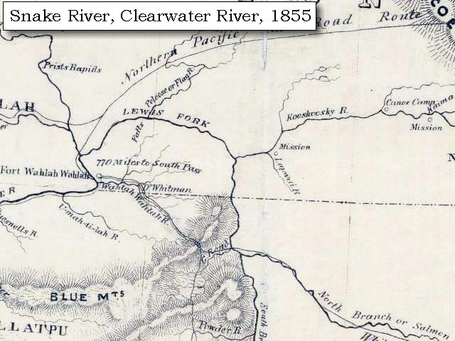
On October 7, 1805, Lewis and Clark and the
"Corps of Discovery" began their journey
down the Clearwater River and into the volcanics
of the Pacific Northwest. The Corps travelled from the
Clearwater to the Snake and down the
"Great Columbia", finally reaching the
Pacific Ocean on November 15, 1805.
Along the journey they encountered the
lava flows of the Columbia Plateau,
river channels carved by the great "Missoula Floods",
and the awesome beauty of five Cascade Range volcanoes.

[Click map for brief summary about the area] |
|
To the Pacific - October 1805
The Journey Begins -- Canoe Camp |
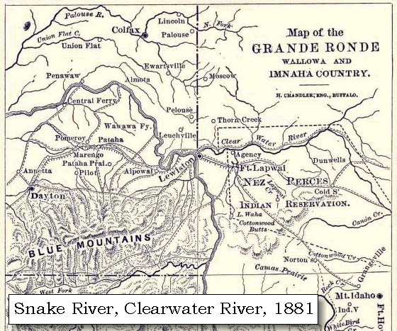
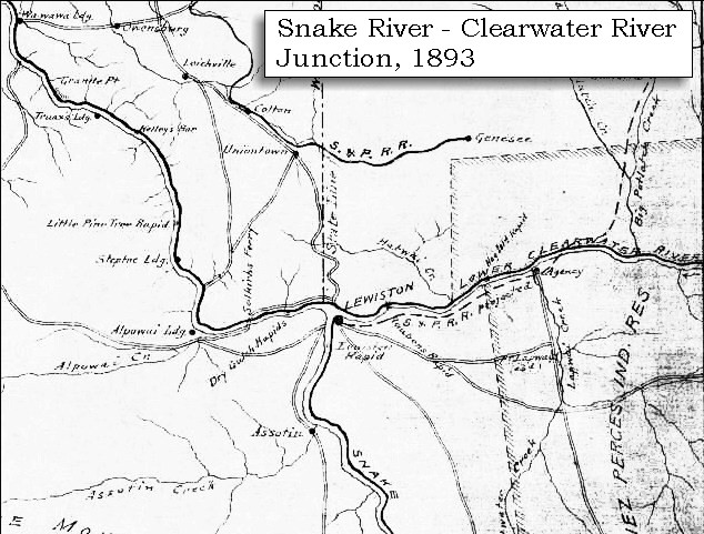
| Between September 26 and October 7, 1805, Lewis and Clark camped at the confluence of the North Fork Clearwater River with the main stem Clearwater River, approximately 4 miles west of today's Orofino, Idaho. This site is called "Canoe Camp". |
| Saturday, October 5, 1805 |
| The wind easterly, and the weather cool. The canoes being nearly finished it became necessary to dispose of our horses. They were therefore collected to the number of thirty-eight, and being branded and marked were delivered to three Indians, the two brothers and the son of a chief, who promises to accompany us down the river [Clearwater River]. To each of these men we gave a knife and some small articles, and they agreed to take good care of the horses till our return. ...... |
|
|
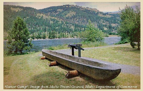
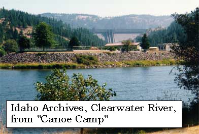
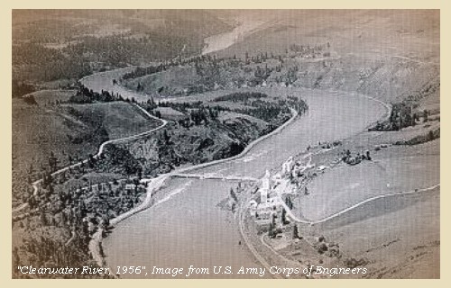
Canoe Camp: Between September 26 and October 7, 1805, Lewis and Clark camped at the confluence of the North Fork Clearwater River with the main stem Clearwater River, approximately 4 miles west of today's Orofino, Idaho. At this site, called "Canoe Camp", the Lewis and Clark expedition, aided by the Nez Perce, built five canoes for their journey down the Columbia River. On October 10, 1805, the Lewis and Clark expedition left the Orofino area to begin their journey down the Clearwater to the Snake and on to the Columbia River. Today, Dworshak Dam, the tallest dam in Idaho, is located approximately one mile upstream of Canoe Camp, on the North Fork Clearwater River. Canoe Camp is part of the Nez Perce National Historic Park. 


Orofino, Idaho: In the winter of 1859, Captain Elias D. Pierce found gold in the Orofino region. Due to restrictions on what had become part of the Nez Perce Reservation, Captain Pierce could not legally come into the area. He returned quietly in the winter of 1860 with a party of 12, camped on Canal Gulch near what is now the town of Pierce, and made a significant gold discovery. That winter, 1860-61, Pierce City and Oro Fino City were established two miles apart. In 1867 Oro Fino burned down and was not rebuilt. Today's Orofino got its start in 1898, with the inflow of settlers and the construction of the Northern Pacific Railroad up Clearwater River. The name Oro Fino (which means "fine gold") was taken from the old gold rush town of "Oro Fino". When the post office objected to two words, the town joined the two words and became Orofino. -- Orofino, Idaho, Chamber of Commerce Website, 2003, and Clearwater, Idaho, Historical Museum Website, 2003 Dworshak Dam: Dworshak Dam is located on the North Fork Clearwater River approximately 5 miles north of Orofino, and approximately one mile north of the North Fork's confluence with the main stem Clearwater River (location of Lewis and Clark's Canoe Camp). The Dworshak Dam is a 717-feet-high concrete dam, the tallest dam in Idaho. Completed in 1971, it is used for flood control and power generation. The reservoir has a storage capacity of 2 million acre feet of water, the largest in the state. -- Idaho Department of Water Resources Website, 2003 Nez Perce National Historical Park: When Nez Perce National Historical Park was created in 1965, it consisted of 24 sites scattered across north central Idaho. Four of the sites were administered by the National Park Service and the remaining 20 were a mixture of other federal, local, and private sites. In 1992 an additional 14 sites were added in the adjoining states of Oregon, Washington, and Montana. Currently, agreements with the property owners are being worked out to provide for public access to each area. -- U.S. National Park Service Website, Nez Perce National Historical Park, 2002 |
| "... Lattitude of this place from the mean of two observations is '46o 34' 56.3" North -- ..." [Clark, October 5, 1805] |
| "... The hills high and ruged and woods too dry to hunt the deer which is the only game in our neighbourhood ..." [Clark, October 5, 1805] |
| Sunday, October 6, 1805 |
| This morning is again cool, and the wind easterly. ...... We had all our saddles buried in a cache near the river [Clearwater River], about half a mile below, and deposited at the same time a canister of powder, and a bag of balls. The time which could be spared from our labours on the canoes, was devoted to some astronomical observations. The latitude of our camp as deduced from the mean of two observations is 46o 34' 56"; 3"'; north. |
| "... The river below this forks is Called 'Kos-kos-kee'. it is Clear rapid with Shoals or Swift places -- The open Countrey Commences a fiew miles below This on each side of the river, on the Lard Side below the 1st Creek. with a few trees Scattered near the river. ..." [Clark, October 6, 1805] |
|
|
Clearwater River: The Clearwater River drains approximately 9,645 square miles, and extends 100 miles north to south and 120 miles east to west. Four major tributaries drain into the mainstem Clearwater River: the Lochsa, Selway, South Fork Clearwater, and North Fork Clearwater Rivers. The Clearwater River has an international reputation as one of the best steelhead fisheries anywhere. The river, along with U.S. Highway 12, are part of the Lewis and Clark National Historic Trail. Developed recreation sites in the area are primarily for boating and fishing, with camping available in a few locations. The North Fork of the Clearwater and the Lochsa Rivers provide miles of tumbling whitewater interspersed with quiet pools for migratory and resident fish. The Clearwater was used as a passageway by explorers and trappers, and later by miners and loggers because it was much more tame than its counterpart the Salmon River. -- Columbia Basin Fish and Wildlife Authority Website, 2002, Visit Idaho Website, 2002, and Idaho Museum of Natural History Website, 2002, Digital Atlas of Idaho


|
|
|
|
The Camp - September 26 to October 7, 1805:
Between September 26 and October 7, 1805, Lewis and Clark camped at the confluence of the North Fork Clearwater River with the main stem Clearwater River, approximately 4 miles west of today's Orofino, Idaho. At this site, called "Canoe Camp", the Lewis and Clark expedition, aided by the Nez Perce, built five canoes for their journey down the Columbia River. Today, Dworshak Dam, the tallest dam in Idaho, is located approximately one mile upstream on the North Fork Clearwater River. Canoe Camp is part of the Nez Perce National Historic Park. |
| Home | Continue |
If you have questions or comments please contact: GS-CVO-WEB@usgs.gov
June/July 2004, Lyn Topinka
The Volcanoes of Lewis and Clark Home Page | CVO Home Page