The Volcanoes of
Lewis and Clark
April 23 - 28, 1806
Up the Columbia - Rock Creek to Walla Walla
 
Home
The Volcanoes of Lewis and Clark

Map of the Journey
Volcanoes, Basalt Plateaus, Major Rivers, etc.

The Volcanoes
Mount Adams, Mount Hood, Mount Jefferson, Mount Rainier, and Mount St. Helens

CALENDAR of the Journey
October 1805 to June 1806

Along the Journey
Pacific Northwest Maps - Columbia River, Volcanoes, Flood Basalts, Missoula Floods, Geology, etc.

The Corps of Discovery
The Journey of Lewis and Clark

About the Reference Materials
The Journals, Biddle/Allen, DeVoto, Gass, Moulton, Topo Maps, and others

USGS Lewis and Clark Links
Links to USGS Websites highlighting the Lewis and Clark Journey

Resources
Publications Referenced and Websites Visited


PREVIOUS

April 22
Up the Columbia, Deschutes to the John Day
April 23-28

Up the Columbia River,
Rock Creek to Walla Walla

Rock Creek, Arlington (Oregon) and Roosevelt (Washington), Alder Creek, Alder Ridge, Crow Butte and Crow Butte State Park, Umatilla NWR, Umatilla River, Wallula Gap, Twin Sisters, Blue Mountains
CONTINUE

April 29
Up the Columbia, Walla Walla
 

On October 7, 1805, Lewis and Clark and the "Corps of Discovery" began their journey down the Clearwater River and into the volcanics of the Pacific Northwest. The Corps travelled from the Clearwater to the Snake and down the "Great Columbia", finally reaching the Pacific Ocean on November 15, 1805. Along the journey they encountered the lava flows of the Columbia Plateau, river channels carved by the great "Missoula Floods", and the awesome beauty of five Cascade Range volcanoes.

Map, Lewis and Clark in the Pacific Northwest, click for brief
                         summary
[Click map for brief summary about the area]


Heading for Home - April 1806
Up the Columbia - Rock Creek to Walla Walla
 

Lewis and Clark's camp of April 22, 1806, was on the Washington side of the Columbia, across from the John Day River.

Wednesday, April 23, 1806
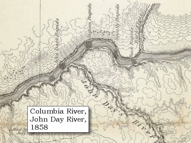
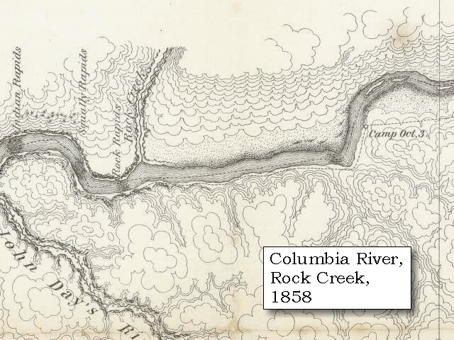
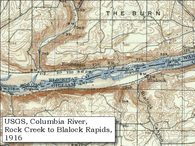
Two of the horses strayed away in consequence of neglecting to tie them as had been directed. One of them was recovered, but as we had a long ride to make before reaching the next village, we could wait no longer than eleven o'clock for the other. Not being found at that time we set out, and after marching for twelve miles over the sands of a narrow rocky bottom on the north side of the river, came to a village near the Rock rapid [Rock Creek Rapids], at the mouth of a large creek [Rock Creek], which we had not observed in descending . ......


Along the Journey - April 23, 1806
Rock Creek at mouth, 2004

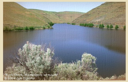
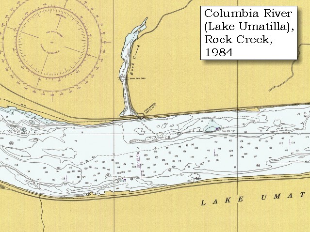
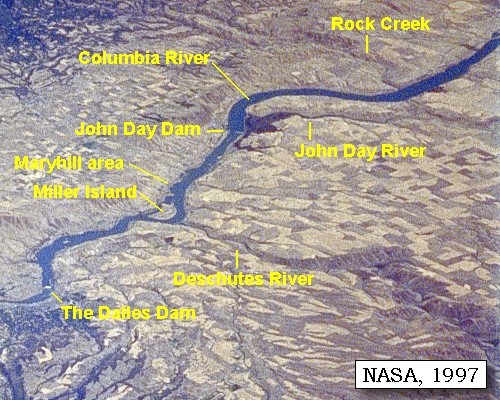
Rock Creek:
Rock Creek basin consists of several small watersheds and encompasses an area of nearly 225 square miles in southeastern Washington. Rock Creek drains into the Columbia River about 12 miles upstream of John Day Lock and Dam. The drainages in the Rock Creek basin originate in the Simcoe Mountains along Bickleton Ridge, which forms the northern boundary of the subbasin and the southern boundary of the Yakama Indian Reservation. Most of the streams flow in a southerly to southeasterly direction to Lake Umatilla, the portion of the Columbia River impounded by the John Day Lock and Dam. The major streams include Badger Gulch, Harrison, Luna Gulch, Quartz and Squaw creeks as well as Rock Creek. Elevations range from 200 feet at the confluence of Rock Creek and the Columbia River to 4,721 feet at Lone Pine Butte. The geology of the Rock Creek basin is dominated by extensive basalt flows having a total thickness of up to 5,000 feet. The basalt in these flows erupted between 14 and 15.5 million years ago. -- Columbia Basin Fish and Wildlife Authority Website, 2002


Map, 1854, Columbia River, Hood River to the John Day, click to enlarge Map, 1858 Military recon map, John Day River and Rock Creek, click to enlarge Map, 1858 Military recon map, Rock Creek, click to enlarge Map, 1916, USGS topo map section, Columbia River with Rock Creek, Four O'clock, Blalock Rapids, and Owyhee Rapids, click to enlarge Map, 1916, USGS topo map section, Columbia River with Rock Creek, Four O'clock, and Blalock Rapids, click to enlarge Map, 1984, Rock Creek, Washington, click to enlarge NASA Image, 1997, Columbia River from The Dalles to Rock Creek, click to enlarge Image, 2004, Rock Creek
  1. 1853-54 Map, Columbia River, including the Hood River to John Day area (section of original). (Click to enlarge). Includes Hood River (Dog River), Klickitat River (Klikatat R.), Mill Creek (?) (Wasco Ck.), The Dalles, The Deschutes (Wanwauwie or des Chutes R.), the John Day River (Mah hah or John Day's R.), and Rock Creek (Camill Cr.). Original Map: "Rocky Mountains to Puget Sound : from explorations and surveys / made under the direction of the Hon. Jefferson Davis, Secretary of War by Isaac I. Stevens Governor of Washington Territory, 1853-4." Inset: (Supplementary sketch) Reconnaissance of the railroad route from Wallawalla to Seattle via Yak-e-mah River & Snoqualmie Pass. By A. W. Tinkham in January 1854. Drawn by J. R. P. Mechlin. 20 x 28 cm. Topographer, John Lambert, Published in Washington D.C., 1859, 1:1,200,000, Notes: From the U.S. War Department, Explorations and Surveys for a Railroad Route from the Mississippi River to the Pacific Ocean, Topographical Maps, to Illustrate the Various Reports, U.S. Library of Congress American Memories Reference "LC Railroad Maps #156". -- U.S. Library of Congress, American Memories Website, 2004
  2. 1858 Military Recon Map (section of original), upstream of Rock Creek. (Click to enlarge). Map of military reconnaissance from Fort Dalles, Oregon, via Fort Wallah-Wallah, to Fort Taylor, Washington Territory, 1858. Shows approximate location of military road constructed 1859 to 1862. From the report and maps of Captain John Mullan, United States Army, G.P.O., 1863. University of Washington Archives #UW85. -- University of Washington Library Archives Website, 2002
  3. 1858 Military Recon Map (section of original), Columbia River and area upstream of Rock Creek. (Click to enlarge). Map of military reconnaissance from Fort Dalles, Oregon, via Fort Wallah-Wallah, to Fort Taylor, Washington Territory, 1858. Shows approximate location of military road constructed 1859 to 1862. From: the report and maps of Captain John Mullan, United States Army G.P.O., 1863. -- Washington State University Library Archives Website, 2002
  4. 1916 Map (section of original), from Arlington 1:125,000 topographic quadrangle. (Click to enlarge). Rock Creek to Arlington, with Rock Creek Rapids, Four O'Clock Rapids, Blalock Rapids, and Owyhee Rapids. Original map surveyed in 1912-1913, contour interval of 50 feet. -- Washington State University Archives Website, 2002
  5. 1916 Map, Rock Creek Rapids and Rock Creek (section of original), from Arlington 1:125,000 topographic quadrangle. (Click to enlarge). Rock Creek Rapids, Four O'Clock Rapids, and Blalock Rapids. Original map surveyed in 1912-1913, contour interval of 50 feet. -- Washington State University Archives Website, 2002
  6. 1984 Map, Rock Creek, Washington (section of original). (Click to enlarge). Office of Coast Surveys, Historical Maps and Charts, Columbia River, John Day Dam to Blalock, 1984, Chart#18535, 1:20,000. -- NOAA Office of Coast Survey Website, 2004
  7. 1997, NASA Image, Columbia River from The Dalles to Rock Creek (Click to enlarge). View from space - northeast looking photograph of Columbia River, The Dalles Dam, John Day Dam, Miller Island, Maryhill area, Deschutes River, John Day River, and Rock Creek, 1997. The Columbia River flows upper right (east) to lower left (west). NASA Earth from Space #STS085-734-085. -- NASA Earth from Space Website, 2002
  8. 2004, Rock Creek, Washington, at mouth looking upstream. (Click to enlarge). Copyright © 2004 Lyn Topinka, private archives, used with permission.


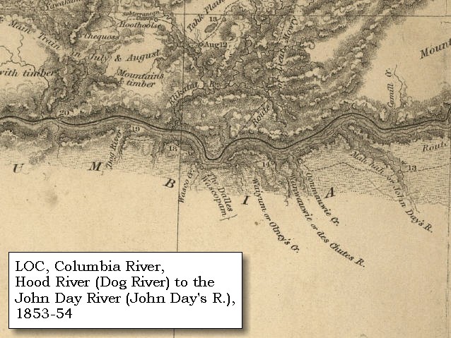
The river [Columbia River] is by no means so difficult of passage nor obstructed by so many rapids as it was in the autumn, the water being now sufficiently high to cover the rocks in the bed.


Along the Journey - April 23, 1806
The Camp - April 23, 1806:
Camped on the Washington side of the Columbia, just below the mouth of Rock Creek.


Thursday, April 24, 1806
We began early to look for our horses, but they were not collected before one o'clock. In the meantime we prepared saddles for three new horses which we purchased from the Wahhowpums, and agreed to hire three more from the Chopunnish Indian who was to accompany us with his family. The natives also had promised to take our canoes in exchange for horses; but when they found that we were resolved on travelling by land, they refused giving us any thing, in hopes that we would be forced to leave them. Disgusted at this conduct, we determined rather to cut them to pieces than suffer these people to enjoy them, and actually began to split them, on which they gave us several strands of beads for each canoe. We had now a sufficient number of horses to carry our baggage, and therefore proceeded wholly by land. At two o'clock we set out, and passing between the hills and the northern shore of the river, had a difficult and fatiguing march over a road alternately sandy and rocky. At the distance of four miles, we came to four huts of the Metcowwee tribe, two miles further the same number of huts, and after making twelve miles from our last night's camp, halted at a larger village of five huts of Metcowwees.
"... We entered the low country, the great and beautiful plains of Columbia, and proceeded on till evening ..." [Gass, April 24, 1806]
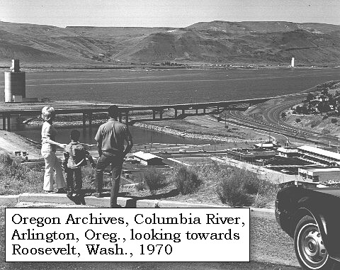
As we came along many of the natives passed and re-passed without making any advances to converse, though they behaved with distant respect. We observed in our route no animals except the killdeer, the brown lizard, and a moonax, which the people had domesticated as a favourite. Most of the men complain of a soreness in their feet and legs, occasioned by walking on rough stones and deep sands, after being accustomed for some months past to a soft soil. We therefore determined to remain here this evening [Washington side near Roosevelt, across from Arlington, Oregon],


Along the Journey - April 24, 1806
Roosevelt, Washington, 2003

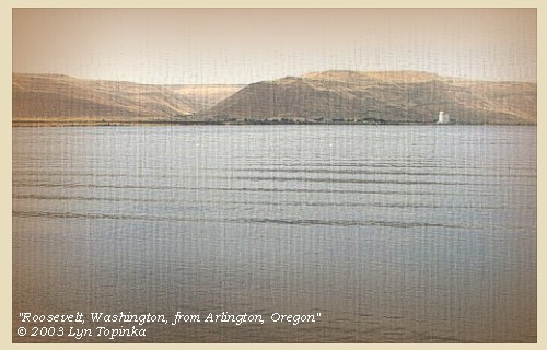
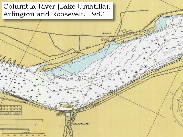
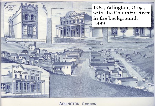
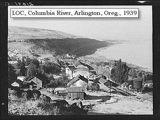
Arlington, Oregon, and Roosevelt, Washington:
Arlington, Oregon, was first settled in 1880, after the area was used through much of the previous decade as a meeting point where cattlemen would gather their cattle for sale. Originally named Alkali (after the Alkali Canyon, which it was located at the mouth of), the name was changed to Arlington in 1885 when the town was incorporated. The entire town of Arlington was relocated just uphill between 1953 and 1973, when the building of the John Day Dam drowned (on January 2nd, 1968) old Arlington for good. Directly across the Columbia River, on the Washington shore, is the town of Roosevelt. -- Washington State University Library Collections Website, 2002


Map, 1916, USGS topo map section, Columbia River with Arlington, Oregon and Roosevelt, Washington, click to enlarge Map, 1982, Columbia River with Arlington, Oregon and Roosevelt, Washington, click to enlarge Engraving, 1889, Arlington, Oregon, click to enlarge Image, 1939, Arlington, Oregon, click to enlarge Image, 1970, overlooking Arlington, Oregon, the Columbia River, and Roosevelt, Washington, click to enlarge Image, 2003, Roosevelt, Washington, from Arlington, Oregon
  1. 1916 Map (section of original), from Arlington 1:125,000 topographic quadrangle. (Click to enlarge). Original map surveyed in 1912-1913, contour interval of 50 feet. -- University of Washington Library Collections Website, 2002
  2. 1982 Map, Arlington, Oregon, and Roosevelt, Washington (section of original). (Click to enlarge). Office of Coast Surveys, Historical Maps and Charts, Columbia River, Sundale to Heppner Junction, 1982, Chart#18536, 1:20,000. -- NOAA Office of Coast Survey Website, 2004
  3. 1889 Engraving, Arlington, Oregon. (Click to enlarge). -- U.S. Library of Congress Website, 2002, American Memories
  4. 1939 Arlington, Oregon. (Click to enlarge). The town of Arlington, Oregon, on the Columbia River, 112 miles from Bonneville Dam. Photographer: Dorothea Lange. Photograph Date: October 1939. Library of Congress Archives #LC-USF34- 021071-C. -- U.S. Library of Congress Website, 2003, American Memories
  5. 1970, Overlooking Arlington, Oregon, the Columbia River, and Roosevelt, Washington. (Click to enlarge). This photo shows part of the small town of Arlington, located on U.S. Route I-84, on the Columbia River, 54 miles east of The Dalles. Arlington, at the junction of the John Day Highway and I-84 was relocated a short distance up the canyon as a result of the construction of The Dalles Dam and the newly created reservoir behind the dam. This picture, taken from an overlook of the town, shows the highway bridge, the new boat basin, a large grain elevator, the Columbia River, and the hills along the Washington State shore (location of Roosevelt, Washington), and another large grain elevator. Photograph Date: June 1970. Oregon State Archives Oregon Highway Division #OHD7441. -- Oregon State Archives Website, 2003
  6. 2003, Roosevelt, Washington, from Arlington, Oregon. (Click to enlarge). Copyright © 2003 Lyn Topinka, private archives, used with permission.


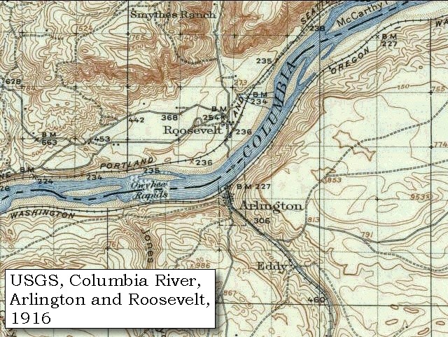
and for this purpose bought three dogs and some chapelell, which we cooked with dry grass and willow boughs. The want of wood is a serious inconvenience, on account of the coolness of the nights, particularly when the wind sets from mount Hood, or in any western direction: those winds being much colder than the winds from the Rocky mountains. There are no dews in the plains, and from the appearance, we presume, that no rain has fallen for several weeks.


Along the Journey - April 24, 1806
The Camp - April 24, 1806:
Washington side of the Columbia near Roosevelt, across from today's Arlington, Oregon. The Camp of April 24, 1806, is downstream of Lewis and Clark's camp of October 20, 1805, on their journey to the Pacific.


Friday, April 25, 1806
We collected our horses and proceeded eleven miles to a large village of fifty-one mat houses ...... We left ...... at four o'clock, accompanied by eighteen or twenty of their young men on horseback. At the distance of four miles, we passed, without halting, five houses belonging to the Wollawollahs; and five miles further, observing as many willows as would answer the purpose of making fires, availed ourselves of the circumstance, by encamping near them. [Washington side of the Columbia River, downstream from the mouth of Alder Creek.]
"... we proceeded on about 9 miles through a Country Similar to that of yesterday and encamped below the mouth of a Small Creek ..." [Clark, April 25, 1806]


Along the Journey - April 25, 1806
USGS topo map detail, Alder Ridge and Alder Creek, 1906

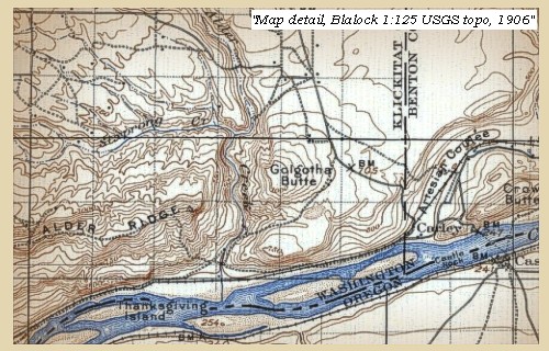
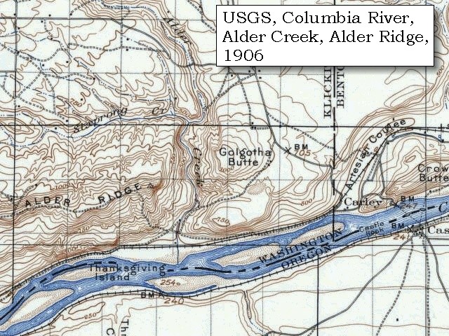
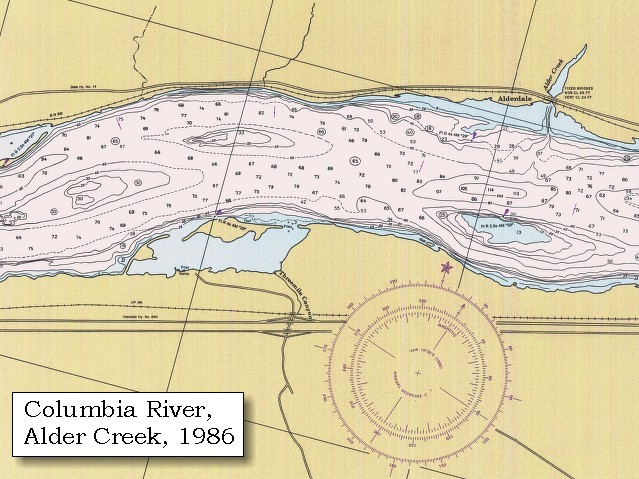
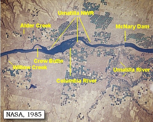
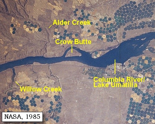
Alder Creek, Washington:
Alder Creek lies on the Washington State side of the Columbia River, at River Mile 258.


Map, 1814, Lewis and Clark on the Columbia, click to enlarge Map, 1906 USGS topo map of Alder Creek and Alder Ridge area, click to enlarge Map, 1986, Alder Creek, Washington, click to enlarge NASA Image, 1985, Columbia River from Willow Creek to McNary Dam, click to enlarge NASA Image, 1985, Columbia River and Crow Butte area, click to enlarge
  1. 1814 Map, Lewis and Clark's map of the Columbia River (section of original). (Click to enlarge.) Alder Creek is depicted but not named (north side of river, right side of map). Map includes three of the five volcanoes Lewis and Clark saw and commented on. While the journals mention the expedition seeing Mount Adams, it does not appear on their map. Mount Jefferson is just visible to the south (bottom) and Mount Rainier is to the north but off the map. From the "Nicholas Biddle/Paul Allen" 1814 publication. Original Map: "A Map of Lewis and Clark's Track, Across the Western Portion of North America, From the Mississippi to the Pacific Ocean". From: History of the expedition under the command of Captains Lewis and Clark : to the sources of the Missouri, thence across the Rocky Mountains and down the river Columbia to the Pacific Ocean : performed during the years 1804-5-6 : by order of the government of the United States / prepared for the press by Paul Allen. Philadelphia : Bradford and Insskeep, 1814. Harold B. Lee Library, Brigham Young University #upbover maps37. -- Brigham Young University, Harold B. Lee Library Website, 2004.
  2. 1906 Map (section of original), from Blalock Island 1:125,000 topographic quadrangle. (Click to enlarge). Original map surveyed in 1906, contour interval of 50 feet. -- University of Washington Library Collections Website, 2002
  3. 1986 Map, Alder Creek, Washington (section of original). (Click to enlarge). Office of Coast Surveys, Historical Maps and Charts, Columbia River, Alderdale to Blalock Islands, 1986, Chart#18537, 1:20,000. -- NOAA Office of Coast Survey Website, 2004
  4. 1985, NASA Image, Columbia River from Willow Creek to McNary Dam (section of original) (Click to enlarge). View from space - Columbia River, Willow Creek, Alder Creek, Crow Butte, Umatilla National Wildlife Refuge vicinity, Umatilla River, McNary Dam, and Lake Umatilla, August, 1985. The Columbia River flows right (east) to left (west). Washington State is the upper half of the image (north) and Oregon is the lower half (south). Lake Umatilla was formed by the John Day dam (not in image). NASA Earth from Space #STS51F-035-0011. -- NASA Earth from Space Website, 2002
  5. 1985, NASA Image, Columbia River and the Crow Butte vicinity (section of original) (Click to enlarge). View from space - Columbia River, Crow Butte, Lake Umatilla, Alder Creek, and Willow Creek, August, 1985. The Columbia River flows right (east) to left (west). Washington State is the upper half of the image (north) and Oregon is the lower half (south). Lake Umatilla was formed by the John Day dam (not in image). NASA Earth from Space #STS51F-035-0011. -- NASA Earth from Space Website, 2002


The country through which we passed bore the same appearance as that of yesterday. The hills on both sides of the river are about two hundred and fifty feet high [Alder Ridge vicinity], generally abrupt and craggy, and in many places presenting a perpendicular face of black, hard, and solid rock. From the top of these hills, the country extends itself in level plains to a very great distance, and though not as fertile as the land near the falls produces an abundant supply of low grass, which is an excellent food for horses. This grass must indeed be unusually nutritious, for even at this season of the year, after wintering on the dry grass of the plains, and being used with greater severity than is usual among the whites, many of these horses are perfectly fat, nor have we, indeed, seen a single one who was poor. ......


Along the Journey - April 25, 1806
Alder Ridge, Washington, 2002

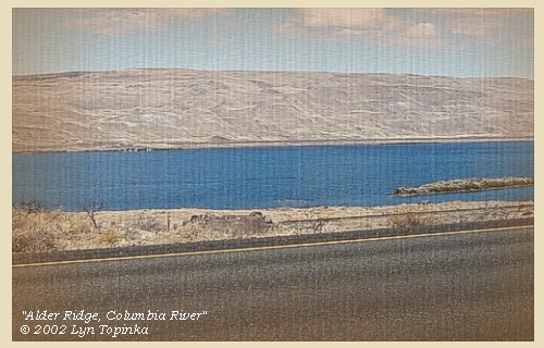
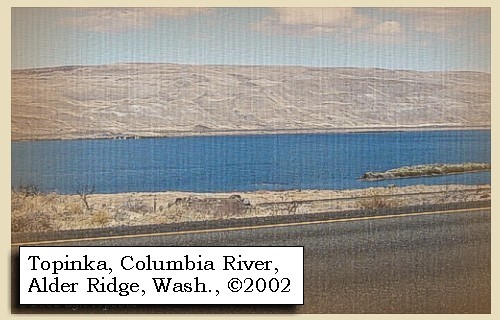
Alder Ridge:
Along the Washington side of the Columbia River, Columbia River basalt.


Map, 1906 USGS topo map of Alder Creek and Alder Ridge area, click to enlarge Image, 2002, Alder Ridge, Washington
  1. 1906 Map (section of original), from Blalock Island 1:125,000 topographic quadrangle. (Click to enlarge). Original map surveyed in 1906, contour interval of 50 feet. -- University of Washington Library Collections Website, 2002
  2. 2002, Alder Ridge, Washington, from across the Columbia River. (Click to enlarge). Copyright © 2002 Lyn Topinka, private archives, used with permission.


"... the Country we passed through was Sandy indifferent rocky and hills on the left. proceeded up on the North Side the river hills are about 250 feet high & generally abrupt and Craggey in maney places faced with a pirpendicular and Solid rock. this rock is black and hard. leavel plains extend themselves from the top of the river hills to a great distance on either Side of the river. the Soil is not as fertile as about the falls tho it produces low grass on which their horses at this Season feed very Conveniently ... I think those plains are much more Sandy than any which I have Seen and the road is a bed of loose Sand. made 20 miles. ..." [Clark, April 25, 1806]


Along the Journey - April 25, 1806
The Camp - April 25, 1806:
Washington side of the Columbia, downstream from the mouth of Alder Creek.


Saturday, April 26, 1806
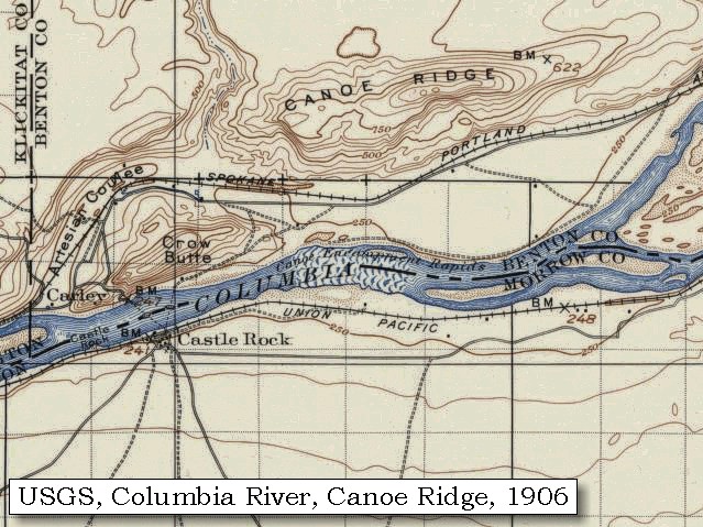
In the morning, we set out early [passing through the Crow Butte and Canoe Ridge area]. At the distance of three miles, the river hills become low, and retiring to a great distance, leave a low, level, extensive plain, which on the other side of the river [Oregon side], had begun thirteen miles lower. As we were crossing this plain, we were overtaken by several families travelling up the river with a number of horses ......


Along the Journey - April 26, 1806
Crow Butte in 1906 and 1994

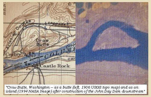
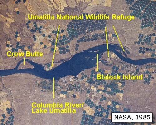
Crow Butte:
Prior to being an island, Crow Butte was a hill. In the 1970's, when John Day Dam was built and flooded the Columbia River, waters formed around Crow Butte, turning it into the island it is today. -- Washington State Parks and Recreation Website, 2002


Map, 1858 Military recon map, Castle Rock and Canoe Encampment Rapids, click to enlarge Map, 1906 USGS topo map of Canoe Ridge area, click to enlarge Map, 1986, Crow Butte, click to enlarge NASA Image, 1994, Columbia River from Crow Butte to the Snake River, click to enlarge NASA Image, 1985, Columbia River from Willow Creek to McNary Dam, click to enlarge NASA Image, 1985, Columbia River and the Umatilla National Wildlife Refuge, click to enlarge NASA Image, 1985, Columbia River and Crow Butte area, click to enlarge
  1. 1858 Military Recon Map (section of original), Blalock Island Vicinity (Long Island). (Click to enlarge). Map of military reconnaissance from Fort Dalles, Oregon, via Fort Wallah-Wallah, to Fort Taylor, Washington Territory, 1858. Shows approximate location of military road constructed 1859 to 1862. From the report and maps of Captain John Mullan, United States Army, G.P.O., 1863. University of Washington Archives #UW85. -- University of Washington Library Archives Website, 2002
  2. 1906 Map Closer-View (section of original), from Blalock Island 1:125,000 topographic quadrangle. (Click to enlarge). Original map surveyed in 1906, contour interval of 50 feet. -- University of Washington Library Collections Website, 2002
  3. 1986 Map, Crow Butte (section of original). (Click to enlarge). Office of Coast Surveys, Historical Maps and Charts, Columbia River, Alderdale to Blalock Islands, 1986, Chart#18537, 1:20,000. -- NOAA Office of Coast Survey Website, 2004
  4. 1994, NASA Image, Columbia River from Crow Butte to the Snake River (section of original) (Click to enlarge). View from space - Columbia River, Snake River, Yakima River, Walla Walla River, Umatilla River, Crow Butte and Wallula Gap, north-looking, low-oblique photograph, September 1994. NASA Earth from Space #STS064-112-093. -- NASA Earth from Space Website, 2002
  5. 1985, NASA Image, Columbia River from Willow Creek to McNary Dam (section of original) (Click to enlarge). View from space - Columbia River, Willow Creek, Alder Creek, Crow Butte, Umatilla National Wildlife Refuge vicinity, Umatilla River, McNary Dam, and Lake Umatilla, August, 1985. The Columbia River flows right (east) to left (west). Washington State is the upper half of the image (north) and Oregon is the lower half (south). Lake Umatilla was formed by the John Day dam (not in image). NASA Earth from Space #STS51F-035-0011. -- NASA Earth from Space Website, 2002
  6. 1985, NASA Image, Columbia River and the Umatilla National Wildlife Refuge, including Blalock Island (section of original) (Click to enlarge). View from space - Columbia River, Crow Butte, Blalock Island, and the Umatilla National Wildlife Refuge vicinity, August, 1985. The Columbia River flows right (east) to left (west). Washington State is the upper half of the image (north) and Oregon is the lower half (south). Lake Umatilla was formed by the John Day dam (not in image). NASA Earth from Space #STS51F-035-0011. -- NASA Earth from Space Website, 2002
  7. 1985, NASA Image, Columbia River and the Crow Butte vicinity (section of original) (Click to enlarge). View from space - Columbia River, Crow Butte, Lake Umatilla, Alder Creek, and Willow Creek, August, 1985. The Columbia River flows right (east) to left (west). Washington State is the upper half of the image (north) and Oregon is the lower half (south). Lake Umatilla was formed by the John Day dam (not in image). NASA Earth from Space #STS51F-035-0011. -- NASA Earth from Space Website, 2002


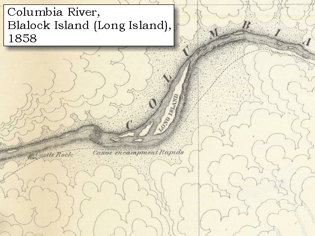
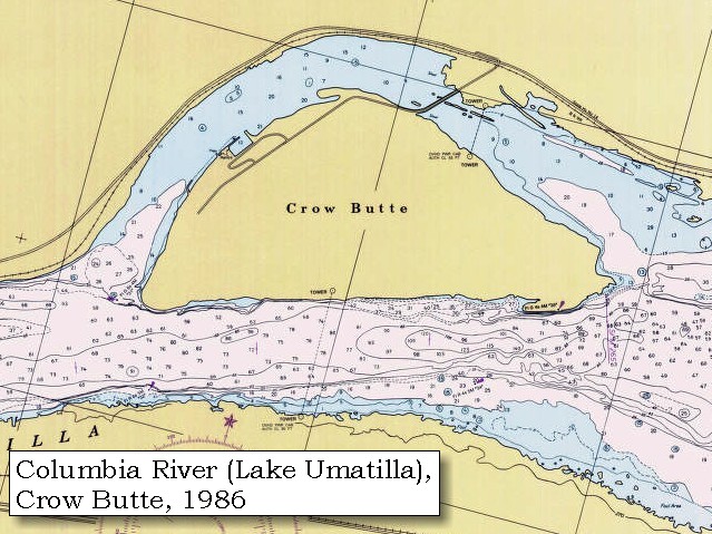
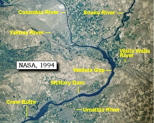
Crow Butte State Park:
Crow Butte State Park is a 1,312-acre camping park with 33,910 feet of freshwater shoreline (750 feet of unguarded beach) on the Columbia River, 13 miles west of Paterson, Washington. (NOTE: Washington State Parks closed Crow Butte Oct. 1, 2002. The park may be closed indefinitely to the public. The U.S. Army Corps of Engineers will determine the future of this park.) When homesteading began in the area in 1850, the Crow family was one of the first to come west. The site of their homestead is now under the waters of the nearby John Day Reservoir, but many of their descendents live in the vicinity. During a 1941 U.S. Army Corps of Engineers survey, the name "Crow Butte" was assigned to the area. The park officially opened in April, 1977. -- Washington State Parks and Recreation Website, 2002, 2004


The plain possesses much grass and a variety of herbaceous plants and shrubs; but after going twelve miles, we were fortunate enough to find a few willows [today's Umatilla National Wildlife Refuge stretches along both sides of the river] ......


Along the Journey - April 26, 1806
Umatilla National Wildlife Refuge, 2003

Umatilla National Wildlife Refuge:
Umatilla National Wildlife Refuge is 29,370 acres of marshes, sloughs, open water, cropland, and sagebrush uplands, and is a nesting area for Great Basin Canada geese and several species of ducks. The refuge typically has 90,000 wintering Canada geese and 200,000 wintering ducks - practically all species of ducks found in the west except sea ducks. The largest number of ducks on the refuge at one time was 458,000 on November 13, 1983. Long-billed curlews and other marsh and water birds nest on the refuge. Mammals include mule deer, coyote, and many smaller species. Walleye, steelhead, salmon, sturgeon, crappie, and bass are found in refuge waters. The refuge is located along the Columbia River in the vicinity of Irrigon, Oregon, and Paterson, Washington. -- U.S. Fish and Wildlife Service Website, 2002


NASA Image, 1985, Columbia River from Willow Creek to McNary Dam, click to enlarge NASA Image, 1985, Columbia River and the Umatilla National Wildlife Refuge, click to enlarge Image, 2003, Columbia River from Boardman, Oregon
  1. 1985, NASA Image, Columbia River from Willow Creek to McNary Dam (section of original) (Click to enlarge). View from space - Columbia River, Willow Creek, Alder Creek, Crow Butte, Umatilla National Wildlife Refuge vicinity, Umatilla River, McNary Dam, and Lake Umatilla, August, 1985. The Columbia River flows right (east) to left (west). Washington State is the upper half of the image (north) and Oregon is the lower half (south). Lake Umatilla was formed by the John Day dam (not in image). NASA Earth from Space #STS51F-035-0011. -- NASA Earth from Space Website, 2002
  2. 1985, NASA Image, Columbia River and the Umatilla National Wildlife Refuge vicinity (section of original) (Click to enlarge). View from space - Columbia River, Crow Butte, Lake Umatilla, and the Umatilla National Wildlife Refuge vicinity, August, 1985. The Columbia River flows right (east) to left (west). Washington State is the upper half of the image (north) and Oregon is the lower half (south). Lake Umatilla was formed by the John Day dam (not in image). NASA Earth from Space #STS51F-035-0011. -- NASA Earth from Space Website, 2002
  3. 2003, Umatilla National Wildlife Refuge, near Boardman, Oregon. (Click to enlarge). Copyright © 2003 Lyn Topinka, private archives, used with permission.


We then went on sixteen miles further, and six miles above our camp of the nineteenth of October [downstream of Irrigon, Oregon], encamped in the rain, about a mile below three houses of Wollawollahs [west of McNary Dam, near Plymouth, Washington]. ......
"... The country is level and has a most beautiful appearance. On these plains there is a species of clover, as large as any I have seen, and has a large red handsome blossom. The leaves are not quite so large as those of the red clover cultivated in the Atlantic States, but has seven and eight leaves on a brance. ..." [Gass, April 26, 1806]
"... Saw considerable of Snow on the mountains to the South & S East. ..." [Ordway, April 26, 1806]


Along the Journey - April 26, 1806
The Camp - April 26, 1806:
Washington side of the Columbia, just west of McNary Dam and southwest of the Washington town of Plymouth.


Sunday, April 27, 1806
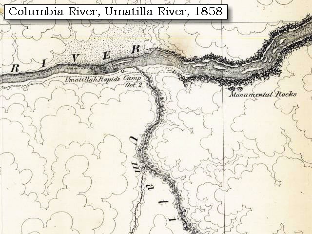
We were detained till nine o'clock, before a horse, which broke loose in the night, could be recovered. We then passed, near our camp, a small river, called Youmalolam [Umatilla River, Oregon side of the Columbia River],


Along the Journey - April 27, 1806
Umatilla River, 2003

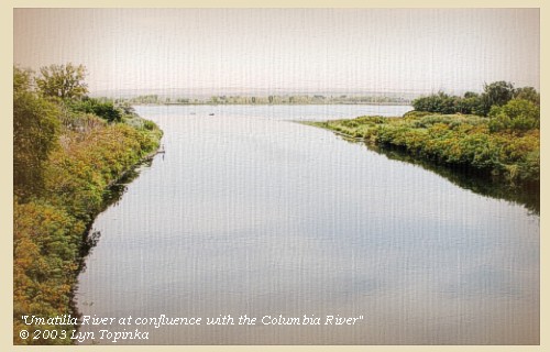
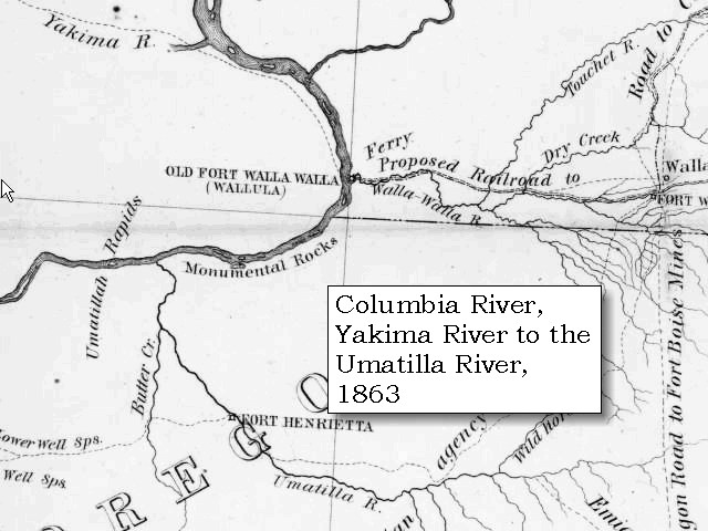
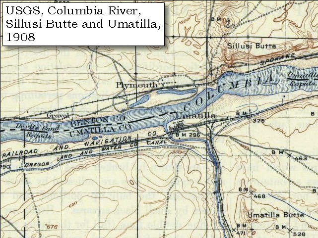
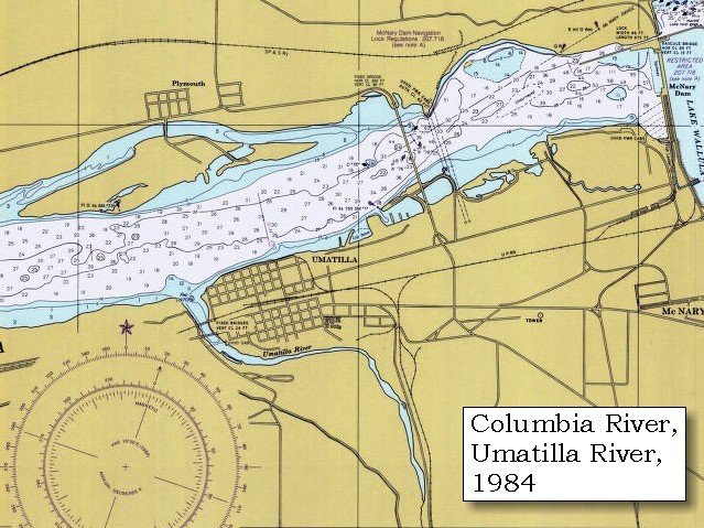
Umatilla River:
The Umatilla River originates on the west slope of the Blue Mountains, east of Pendleton, Oregon. It flows 115 miles north and west to enter the Columbia River at River Mile (RM) 289, draining an area of nearly 2,290 square miles. The mouth of the Umatilla River is at approximately 270 feet elevation above mean sea level. The headwaters are as high as 4,950 feet. The south and east portions of the Umatilla drainage lie on the steep, timbered slopes of the Blue Mountains within the Umatilla National Forest. The remainder of the drainage consists of moderate slopes and level terrain. Lewis and Clark called the river "You ma lolam River". They missed the river in 1805, but added it to the route maps on the return trip in 1806. The river's name was standardized when Wilkes charted it in 1841. Umatilla Landing was established at the mouth of the river in 1863, an important steamboat landing on the Columbia for mines in Oregon and Idaho. White River -- Bonneville Power Administration Website, 2002, Columbia Basin Fish and Wildlife Authority Website, 2004, and Washington State Historical Society Website, 2004, "Lasting Legacy".


Map, 1814, Lewis and Clark on the Columbia, click to enlarge Map, 1837, Columbia River with Mount Hood, click to enlarge Map, 1853, Washington and Oregon and the Columbia River, click to enlarge Map, 1854, Columbia River, Willow Creek to Walla Walla, click to enlarge Map, 1855, Clearwater and Snake from Canoe Camp to the Columbia, click to enlarge Map, 1858 Military recon map, mouth of the Umatilla River, click to enlarge Map, 1863, Umatilla, Walla Walla, Touchet Rivers, etc., click to enlarge Map, 1908 USGS topo map of Umatilla area, click to enlarge Map, 1984, Umatilla River, Umatilla, and McNary Dam, click to enlarge NASA Image, 1985, Columbia River from Willow Creek to McNary Dam, click to enlarge NASA Image, 1985, Columbia River and the Umatilla National Wildlife Refuge, click to enlarge NASA Image, 1994, Columbia River from Crow Butte to the Snake River, click to enlarge NASA Image, 1994, Columbia River, including Umatilla River, click to enlarge Image, 2003, Umatilla River
  1. 1814 Map, Lewis and Clark's map of the Columbia River (section of original). (Click to enlarge.) Shows the Umatilla River ("You-ma-lolam R."). Map also includes three of the five volcanoes Lewis and Clark saw and commented on. While the journals mention the expedition seeing Mount Adams, it does not appear on their map. Mount Jefferson is just visible to the south (bottom) and Mount Rainier is to the north but off the map. From the "Nicholas Biddle/Paul Allen" 1814 publication. Original Map: "A Map of Lewis and Clark's Track, Across the Western Portion of North America, From the Mississippi to the Pacific Ocean". From: History of the expedition under the command of Captains Lewis and Clark : to the sources of the Missouri, thence across the Rocky Mountains and down the river Columbia to the Pacific Ocean : performed during the years 1804-5-6 : by order of the government of the United States / prepared for the press by Paul Allen. Philadelphia : Bradford and Insskeep, 1814. Harold B. Lee Library, Brigham Young University #upbover maps37. -- Brigham Young University, Harold B. Lee Library Website, 2004.
  2. 1837 Map, Columbia River with Mount Hood (section of original). (Click to enlarge). Includes the Umatilla River ("Ottalais R."). Original Map: Map of the Territory West of the Rocky Mountains (1837) Author: Washington Irving, Publisher: Philadelphia, Carey, Lea, & Blanchard. Washington State University Archives #WSU555. -- Washington State University Early Washington Maps Digital Collection Website, 2004
  3. 1853 Map, Washington and Oregon and the Columbia River, from the Clearwater River to the Snake River and down the Columbia River to the Pacific Ocean (section of original). (Click to enlarge). Includes: Clearwater River (Kooskooski), Lapwai Creek (Lapwai R.), Snake River (Saptin or Lewis R.), Columbia River (Columbia R.), Yakima River (Yakima R.), Walla Walla River (Wallawalla R.), Umatilla River (Umatilla R.), Willow Creek (Quesnells R.), John Day River (John day's R.), Deschutes River (Fall R.), Willamette River (Willammette R.), and Cowlitz River (Cowlitz R.). Original Map: "Map of California, Oregon, Washington, Utah, and New Mexico (1853)", by Thomas Cowperthwait & Co. Washington State University Archives #WSU22. -- Washington State University Library Collections Website, 2003
  4. 1853-54 Map, Columbia River, including the Wallula Gap area (section of original). (Click to enlarge). Includes Horse Heaven Hills ("lands destitute of timber"), Willow Creek, Umatilla River, Walla Walla River, Touchet River, Twin Sisters ("Chimney Rock"), Yakima River, and the junction of the Snake River (only the "S" shows) with the Columbia. Original Map: "Rocky Mountains to Puget Sound : from explorations and surveys / made under the direction of the Hon. Jefferson Davis, Secretary of War by Isaac I. Stevens Governor of Washington Territory, 1853-4." Inset: (Supplementary sketch) Reconnaissance of the railroad route from Wallawalla to Seattle via Yak-e-mah River & Snoqualmie Pass. By A. W. Tinkham in January 1854. Drawn by J. R. P. Mechlin. 20 x 28 cm. Topographer, John Lambert, Published in Washington D.C., 1859, 1:1,200,000, Notes: From the U.S. War Department, Explorations and Surveys for a Railroad Route from the Mississippi River to the Pacific Ocean, Topographical Maps, to Illustrate the Various Reports, U.S. Library of Congress American Memories Reference "LC Railroad Maps #156". -- U.S. Library of Congress, American Memories Website, 2004
  5. 1855 Map, Clearwater and Snake Rivers, including the Umatilla River (U-mah-ti-lah R.) (section of original). (Click to enlarge). Original Map: "Map of Oregon and Washington Territories: showing the proposed Northern Railroad route to the Pacific Ocean, by John Disturnell, 1855. University of Washington Archives #UW155. -- University of Washington Library Collections Website, 2002
  6. 1858 Military Recon Map (section of original), Mouth of the Umatilla River. (Click to enlarge). Map of military reconnaissance from Fort Dalles, Oregon, via Fort Wallah-Wallah, to Fort Taylor, Washington Territory, 1858. Shows approximate location of military road constructed 1859 to 1862. From the report and maps of Captain John Mullan, United States Army, G.P.O., 1863. University of Washington Archives #UW85. -- University of Washington Library Archives Website, 2002
  7. 1863 Map (section of original), Columbia River, Umatilla Rapids, Monumental Rocks, Umatilla River, Walla Walla River, Touchet River, etc. (Click to enlarge). Original map by John Mullan, Julius Bien, and Edward Freyhold, United State Office of Explorations and Surveys. Prepared from field notes from 1858-1863. Scale 1:1,000,000. Original map from: report and maps of Captain John Mullan, United States Army, of his operations while engaged in the construction of a military road from Fort Walla-Walla, on the Columbia River, to Fort Benton, on the Missouri River, 1863. -- University of Washington Library Archives Website, 2002
  8. 1908 Map, mouth of the Umatilla River (section of original), from Umatilla 1:125,000 topographic quadrangle. (Click to enlarge). Original map surveyed in 1907, contour interval of 50 feet. What is marked "Devils Bend Rapids" on this topo map corresponds to "Umatilla Rapids" on the 1858 and 1863 maps. The 1858 and 1863 "Umatilla Rapids" are downstream of the mouth of the Umatilla River. -- University of Washington Library Collections Website, 2002
  9. 1984 Map, Umatilla River, Umatilla, and McNary Dam (section of original). (Click to enlarge). Office of Coast Surveys, Historical Maps and Charts, Columbia River, Blalock Islands to McNary Dam, 1984, Chart#18539, 1:20,000. -- NOAA Office of Coast Survey Website, 2004
  10. 1985, NASA Image, Columbia River from Willow Creek to McNary Dam (section of original) (Click to enlarge). View from space - Columbia River, Willow Creek, Alder Creek, Crow Butte, Umatilla National Wildlife Refuge vicinity, Umatilla River, McNary Dam, and Lake Umatilla, August, 1985. The Columbia River flows right (east) to left (west). Washington State is the upper half of the image (north) and Oregon is the lower half (south). Lake Umatilla was formed by the John Day dam (not in image). NASA Earth from Space #STS51F-035-0011. -- NASA Earth from Space Website, 2002
  11. 1985, NASA Image, Closer-in view Columbia River and the Umatilla National Wildlife Refuge vicinity (section of original) (Click to enlarge). View from space - Columbia River, Crow Butte, Lake Umatilla, and the Umatilla National Wildlife Refuge vicinity, August, 1985. The Columbia River flows right (east) to left (west). Washington State is the upper half of the image (north) and Oregon is the lower half (south). Lake Umatilla was formed by the John Day dam (not in image). NASA Earth from Space #STS51F-035-0011. -- NASA Earth from Space Website, 2002
  12. 1994, NASA Image, Columbia River from Crow Butte to the Snake River (section of original) (Click to enlarge). View from space - Columbia River, Snake River, Yakima River, Walla Walla River, Umatilla River, Crow Butte and Wallula Gap, north-looking, low-oblique photograph, September 1994. NASA Earth from Space #STS064-112-093. -- NASA Earth from Space Website, 2002
  13. 1994, NASA Image, Columbia River, including the Umatilla River (section of original) (Click to enlarge). View from space - Columbia River, McNary Dam, Umatilla River, Sillusi Butte vicinity, Juniper Canyon, and Spring Gulch, north-looking, low-oblique photograph, September 1994. NASA Earth from Space #STS064-112-093. -- NASA Earth from Space Website, 2002
  14. 2003, Umatilla River, Oregon, at its confluence with the Columbia River. (Click to enlarge). Copyright © 2003 Lyn Topinka, private archives, used with permission.


proceeded through a continuation, till at the distance of fifteen miles, the abrupt and rocky hills three hundred feet high, return to the river [entering Wallula Gap area]. These we ascended, and then crossed a higher plain for nine miles, when we again came to the water side.
"... at the distance of fifteen miles passed through a country similar to that of yesterday; the hills at the extremity of this distance again approach the river and are rocky abrupt and 300 feet high. we ascended the hill and marched through a high plain 9 miles when we again returned to the river ..." [Lewis, April 27, 1806]


Along the Journey - April 27, 1806
Wallula Gap, 2003

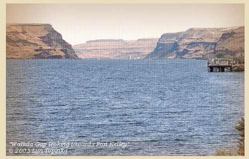
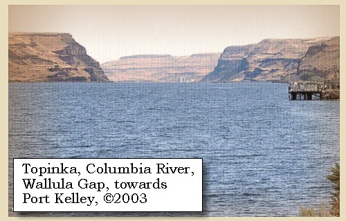
Wallula Gap:
Glacial-outburst waters which crossed the Channeled Scablands during the Missoula Floods were channeled through Wallula Gap. For several weeks, as much as 200 cubic miles of water per day were delivered to a gap that could discharge less than 40 cubic miles per day. Ponded water filled the Pasco Basin and the Yakima and Touchet valleys to form temporary Lake Lewis. -- U.S. National Park Service, National Natural Landmarks Program Website, 2002


Map, 1814, Lewis and Clark on the Columbia, click to enlarge Map, 1854, Columbia River, Willow Creek to Walla Walla, click to enlarge NASA Image, 1994, Columbia River from Crow Butte to the Snake River, click to enlarge NASA Image, 1994, Columbia River and Wallula Gap, click to enlarge Image, 2003, Wallula Gap
  1. 1814 Map, Lewis and Clark's map of the Columbia River (section of original). (Click to enlarge.) Shows the Wallula Gap (right of map, Columbia cutting through mountain chain). Map also includes three of the five volcanoes Lewis and Clark saw and commented on. While the journals mention the expedition seeing Mount Adams, it does not appear on their map. Mount Jefferson is just visible to the south (bottom) and Mount Rainier is to the north but off the map. From the "Nicholas Biddle/Paul Allen" 1814 publication. Original Map: "A Map of Lewis and Clark's Track, Across the Western Portion of North America, From the Mississippi to the Pacific Ocean". From: History of the expedition under the command of Captains Lewis and Clark : to the sources of the Missouri, thence across the Rocky Mountains and down the river Columbia to the Pacific Ocean : performed during the years 1804-5-6 : by order of the government of the United States / prepared for the press by Paul Allen. Philadelphia : Bradford and Insskeep, 1814. Harold B. Lee Library, Brigham Young University #upbover maps37. -- Brigham Young University, Harold B. Lee Library Website, 2004.
  2. 1853-54 Map, Columbia River, including the Wallula Gap area (section of original). (Click to enlarge). Includes Horse Heaven Hills ("lands destitute of timber"), Willow Creek, Umatilla River, Walla Walla River, Touchet River, Twin Sisters ("Chimney Rock"), Yakima River, and the junction of the Snake River (only the "S" shows) with the Columbia. Original Map: "Rocky Mountains to Puget Sound : from explorations and surveys / made under the direction of the Hon. Jefferson Davis, Secretary of War by Isaac I. Stevens Governor of Washington Territory, 1853-4." Inset: (Supplementary sketch) Reconnaissance of the railroad route from Wallawalla to Seattle via Yak-e-mah River & Snoqualmie Pass. By A. W. Tinkham in January 1854. Drawn by J. R. P. Mechlin. 20 x 28 cm. Topographer, John Lambert, Published in Washington D.C., 1859, 1:1,200,000, Notes: From the U.S. War Department, Explorations and Surveys for a Railroad Route from the Mississippi River to the Pacific Ocean, Topographical Maps, to Illustrate the Various Reports, U.S. Library of Congress American Memories Reference "LC Railroad Maps #156". -- U.S. Library of Congress, American Memories Website, 2004
  3. 1994, NASA Image, Columbia River from Crow Butte to the Snake River (section of original) (Click to enlarge). View from space - Columbia River, Snake River, Yakima River, Walla Walla River, Umatilla River, Crow Butte and Wallula Gap, north-looking, low-oblique photograph, September 1994. NASA Earth from Space #STS064-112-093. -- NASA Earth from Space Website, 2002
  4. 1994, NASA Image, Closer-in view Columbia River and Wallula Gap (section of original) (Click to enlarge). View from space - Columbia River, Snake River, Lake Wallula, and the Wallula Gap, north-looking, low-oblique photograph, September 1994. NASA Earth from Space #STS064-112-093. -- NASA Earth from Space Website, 2002
  5. 2003, Wallula Gap, from downstream, looking towards Port Kelley. (Click to enlarge). Copyright © 2003 Lyn Topinka, private archives, used with permission.


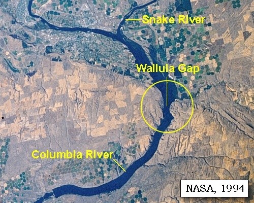
Prominent Lava Flows seen from Wallula Gap vicinity:
Horse Heaven Hills anticline sections show excellent exposures of the thick Frenchman Springs member overlain by the Umatilla Member of the Saddle Mountains Basalt -- the Roza and Priest Rapids Members are missing. A Martindale flow caps the highest visible point west of the river; it overlies imbricated Snake River gravel, compositionally similar to that at Lower Monumental Dam, showing that an ancestral Wallula Gap existed at least 8.5 million years ago. The Saddle Mountains Basalt formation is the youngest in the Columbia River Basalt Group. It is about 13.5 to 6 million years old and contains flows erupted sporadically during a period of waning volcanism, deformation, canyon cutting, and development of thick but local sedimentary deposits between flows. The Saddle Mountains Basalt has a volume of only about 700 cubic miles, less than one percent of the total volume of basalt, yet contains by far the greatest chemical and isotopic diversity of any formation in the group. -- Swanson and Wright, 1981


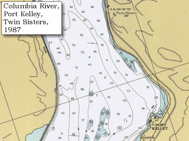
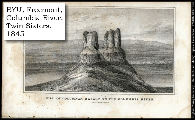
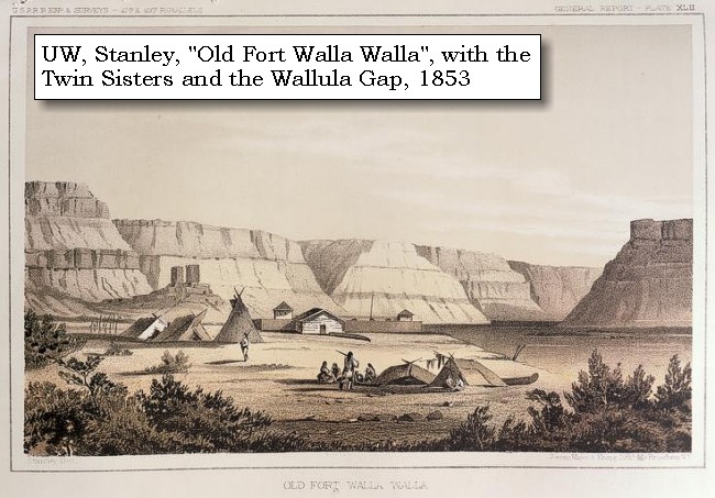
On the left bank of the Columbia River, within the Wallula Gap, lies a basalt feature known as the "Twin Sisters".


Along the Journey - April 27, 1806
Etching detail, Twin Sisters, 1853

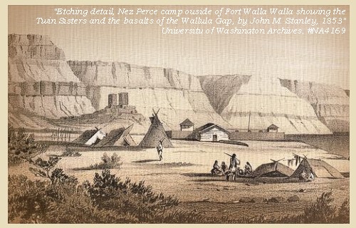
Twin Sisters:
A natural Native American monument overlooks the Columbia River two miles southwest from Wallula Junction on Highway 730. The Twin Sisters are actually two basalt pillars (Frenchman Springs) which were formed by the Missoula Floods about 15,000 years ago. The Twin Sisters are from a single lava flow that stood up to the ravages of the floodwaters, which completely surrounded and submerged them. Apparently the basalt here is slightly harder and/or more resistant to erosion than the basalt around them. Cayuse legend has it that Coyote, an animal spirit, turned two beautiful sisters to stone in a rage of jealousy. There is a nice pullout from Highway 730 with a new sign by the U.S. Army Corps of Engineers that describes the legend and the surrounding area. -- Walla Walla Chamber of Commerce Website, 2002, Lewis and Clark Bicentennial in Oregon Website, 2002, U.S. Army Corps of Engineers Website, 2002, and Pacific Northwest National Laboratory Website, 2003


Map, 1854, Columbia River, Willow Creek to Walla Walla, click to enlarge Map, 1987, Twin Sisters and Port Kelley, Washington, click to enlarge Engraving, 1845, Twin Sisters, click to enlarge Engraving, 1853, Old Fort Walla Walla, click to enlarge
  1. 1853-54 Map, Columbia River, including the Wallula Gap area (section of original). (Click to enlarge). Includes Horse Heaven Hills ("lands destitute of timber"), Willow Creek, Umatilla River, Walla Walla River, Touchet River, Twin Sisters ("Chimney Rock"), Yakima River, and the junction of the Snake River (only the "S" shows) with the Columbia. Original Map: "Rocky Mountains to Puget Sound : from explorations and surveys / made under the direction of the Hon. Jefferson Davis, Secretary of War by Isaac I. Stevens Governor of Washington Territory, 1853-4." Inset: (Supplementary sketch) Reconnaissance of the railroad route from Wallawalla to Seattle via Yak-e-mah River & Snoqualmie Pass. By A. W. Tinkham in January 1854. Drawn by J. R. P. Mechlin. 20 x 28 cm. Topographer, John Lambert, Published in Washington D.C., 1859, 1:1,200,000, Notes: From the U.S. War Department, Explorations and Surveys for a Railroad Route from the Mississippi River to the Pacific Ocean, Topographical Maps, to Illustrate the Various Reports, U.S. Library of Congress American Memories Reference "LC Railroad Maps #156". -- U.S. Library of Congress, American Memories Website, 2004
  2. 1987 Map, Twin Sisters and Port Kelley, Washington (section of original). (Click to enlarge). Office of Coast Surveys, Historical Maps and Charts, Columbia River, Juniper to Pasco, 1987, Chart#18542, 1:20,000. -- NOAA Office of Coast Survey Website, 2004
  3. 1845 Engraving, Columbia River and Twin Sisters. (Click to enlarge). Caption reads: "Hill of Columnar Basalt on the Columbia River". Brigham Young University, Harold B. Lee Library Special Collections, #V978.02F886r1845. -- Brigham Young University, Harold B. Lee Libarary Website, 2004
  4. 1853 Engraving, Nez Perce camp outside walls of Old Fort Walla Walla on the Columbia River, Washington. (Click to enlarge). Engraving by John M. Stanley, 1853. From: University of Washington Library Collection #NA4169. Original from U.S. War Department's Reports of explorations and surveys to ascertain the most practicable and economical route for a railroad from the Mississippi River to the Pacific Ocean, 1860, v.12, pt.1, pl.42. -- University of Washington Library Collection Website, 2002


We had been induced to make this long march because we had but little provisions, and hoped to find a Wollawollah village, which our guide had told us we should reach when next we met the river. There was, however, no village to be seen, and as both the men and horses were fatigued, we halted, and collecting some dry stalks of weeds and the stems of a plant resembling southern wood, cooked a small quantity of jerked meat for dinner. Soon after we were joined by seven Wollawollahs, among whom we recognised a chief by the name of Yellept, who had visited us on the nineteenth of October, when we gave him a medal with the promise of a larger one on our return. He appeared very much pleased at seeing us again, and invited us to remain at his village [Washington side of the Columbia, downstream from the confluence of the Walla Walla River with the Columbia] three or four days, during which he would supply us with the only food they had, and furnish us with horses for our journey. After the cold, inhospitable treatment we have lately received, this kind offer was peculiarly acceptable, and after a hasty meal, we accompanied him to his village, six miles above, situated on the edge of the low country, and about twelve miles below the mouth of Lewis's river [Snake River]. ......


Along the Journey - April 27, 1806
The Camp - April 27 and 28, 1806:
In Benton County, Oregon, on the right bank of the Columbia River, just south of the confluence of the Walla Walla River and the Columbia River. Nearby are the basalt pillars of the Two Sisters. This area today is under the waters of Lake Wallula.


They now informed us that opposite to the village, there was a route which led to the mouth of the Kooskooskee [Clearwater River], on the south side of Lewis's river [Snake River], that the road itself was good, and passed over level country, well supplied with water and grass, and that we should meet plenty of deer and antelope. We knew that a road in that direction would shorten the distance at least eighty miles and as the report of our guide was confirmed by Yellept and other Indians, we did not hesitate to adopt that course; they added, however, that there were no houses or permanent residence of Indians on the road, and it was therefore deemed prudent not to trust wholly to our guns, but to lay in a stock of provisions.


Monday, April 28, 1806
We were now anxious to depart, and requested Yellept to lend us canoes for the purpose of crossing the river. But he would not listen to any proposal of leaving the village. He wished us to remain two or three days; but would not let us go to-day, for he had already sent to invite his neighbours, the Chimnapoos, to come down this evening and join his people in a dance for our amusement. ...... we then crossed with our horses, and having hobbled them, returned to their camp. ......


Along the Journey - April 28, 1806
The Camp - April 27 and 28, 1806:
In Benton County, Oregon, on the left bank of the Columbia River just south of the confluence of the Walla Walla River and the Columbia River. Nearby are the basalt pillars of the Two Sisters. This area today is under the waters of Lake Wallula.


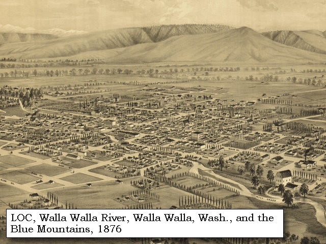
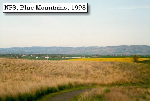
"... From this place we can discover a range of mountains, covered with snow, in a southeast direction and about fifty miles distant [Blue Mountains] . In the evening the weather was cloudy, and it thundered and threatened rain, a few drops of which fell. We remained here all night ..." [Gass, April 28, 1806]


Along the Journey - April 28, 1806
Blue Mountains, 1998

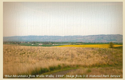
Blue Mountains:
The topography of the Blue Mountains consists of flat-topped ridges and steep stair-stepped valley walls formed by thousands of feet of Miocene basalt flows that engulfed the folded, faulted, and uplifted granitic core of the mountains. As mountains were uplifted, streams and glaciers carved canyons through the basalt layers. -- Columbia Basin Fish and Wildlife Authority Website, 2004


Map, 1814, Lewis and Clark on the Columbia, click to enlarge Map, 1855, Clearwater and Snake from Canoe Camp to the Columbia, click to enlarge Map, 1881, Snake, Clearwater, Grande Ronde, Salmon, click to enlarge Engraving, 1876, 'Birds eye view' of Walla Walla and the Blue Mountains, click to enlarge Image, 1998, Blue Mountains, click to enlarge
  1. 1814 Map, Lewis and Clark's map of the Columbia River (section of original). (Click to enlarge.) Shows the Blue Mountains (right side of map, horizontal chain of moutains). Map also includes three of the five volcanoes Lewis and Clark saw and commented on. While the journals mention the expedition seeing Mount Adams, it does not appear on their map. Mount Jefferson is just visible to the south (bottom) and Mount Rainier is to the north but off the map. From the "Nicholas Biddle/Paul Allen" 1814 publication. Original Map: "A Map of Lewis and Clark's Track, Across the Western Portion of North America, From the Mississippi to the Pacific Ocean". From: History of the expedition under the command of Captains Lewis and Clark : to the sources of the Missouri, thence across the Rocky Mountains and down the river Columbia to the Pacific Ocean : performed during the years 1804-5-6 : by order of the government of the United States / prepared for the press by Paul Allen. Philadelphia : Bradford and Insskeep, 1814. Harold B. Lee Library, Brigham Young University #upbover maps37. -- Brigham Young University, Harold B. Lee Library Website, 2004.
  2. 1855 Map, Clearwater and Snake Rivers, including the Blue Mountains (section of original). (Click to enlarge). Original Map: "Map of Oregon and Washington Territories: showing the proposed Northern Railroad route to the Pacific Ocean, by John Disturnell, 1855. University of Washington Archives #UW155. -- University of Washington Library Collections Website, 2002
  3. 1881 Map, Snake, Clearwater, Grande Ronde, and Salmon Rivers (section of original). (Click to enlarge). Original Map: "Map of the Grande Ronde Wallowa and Imnaha Country, 1881". Map section shows the Snake River (name doesn't show), "Clear Water" River (central right, tributary to the Snake), Grande Ronde River (lower left, only "de River" shows, tributary to the Snake), Salmon River (lower right, tributary to the Snake) Lewiston, Central Ferry, Alpowai, Dayton, Pataha, and the Blue Mountains. By H. Chandler, Eng., Buffalo, 1881., Washington State University Historical Maps Collection #WSU468. -- Washington State University Library Archives Website, 2002
  4. 1876 Engraving, "Birds eye view" of Walla Walla, Washington Territory, with the Blue Mountains 9 miles distant. (Click to enlarge). Drawn by E.S. Glover. A.L. Bancroft & Co., lithographers. Perspective map not drawn to scale. "From the west, looking east." Includes index to points of interest and text. -- U.S. Library of Congress, American Memories Website, 2002
  5. 1998, Blue Mountains from the Whitman Mission (Click to enlarge). National Park Service, Whitman Mission National Historic Site Negative #cmb-1998-12. -- U.S. National Park Service Website, 2002, Whitman Mission National Historic Site


Home Previous Continue


If you have questions or comments please contact: GS-CVO-WEB@usgs.gov
June/July 2004, Lyn Topinka
The Volcanoes of Lewis and Clark Home Page | CVO Home Page