The Volcanoes of
Lewis and Clark
Lewis and Clark
|
April 22, 1806 Up the Columbia - Deschutes to the John Day |
|
Home
The Volcanoes of Lewis and Clark Map of the Journey Volcanoes, Basalt Plateaus, Major Rivers, etc. The Volcanoes Mount Adams, Mount Hood, Mount Jefferson, Mount Rainier, and Mount St. Helens CALENDAR of the Journey October 1805 to June 1806 Along the Journey Pacific Northwest Maps - Columbia River, Volcanoes, Flood Basalts, Missoula Floods, Geology, etc. The Corps of Discovery The Journey of Lewis and Clark About the Reference Materials The Journals, Biddle/Allen, DeVoto, Gass, Moulton, Topo Maps, and others USGS Lewis and Clark Links Links to USGS Websites highlighting the Lewis and Clark Journey Resources Publications Referenced and Websites Visited |
PREVIOUS
April 21 Up the Columbia, Celilo Falls to the Deschutes |
April 22
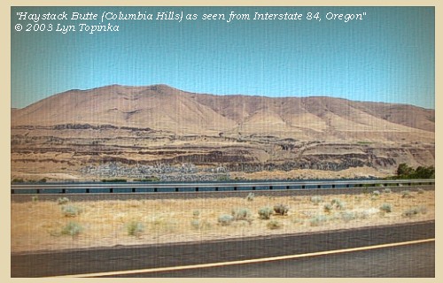
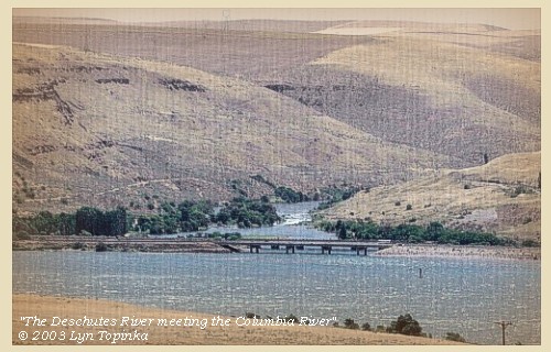
Up the Columbia, Deschutes to the John Day Haystack Butte and the Columbia Hills, Mount Hood and Mount Jefferson, Deschutes River, Deschutes River State Recreation Area, Five-Mile Rapids and U.S. Highway 97 Bridge, Maryhill Museum, Maryhill State Park and Stonehenge Memorial, John Day Dam, John Day River and LePage Park |
CONTINUE
April 23-29 Up the Columbia, Rock Creek to Walla Walla |
|
Heading for Home - April 1806
Up the Columbia - Deschutes to the John Day |
| Lewis and Clark's camp camp of April 21, 1806, was on the Washington side of the Columbia along the Columbia Hills near Haystack Butte, across from the mouth of the Deschutes River, Oregon. |
| Tuesday, April 22, 1806 |
| Two of our horses broke loose in the night [April 21, 1806] and straggled to some distance, so that we were not able to retake them and begin our march before seven o'clock. We had just reached the top of a hill near the village, [Columbia Hills area near Haystack Butte] when the load of one of the horses turned, and the animal taking fright at a robe which still adhered to him, ran furiously towards the village ...... |
| "... at 7 oClock we loaded up and Set out, haveing previously Sent off the Canoe with Coulter and Potts we had not arived at the top of the hill which is 200 feet before Shabonos horse threw off his load ..." [Clark, April 22, 1806] |
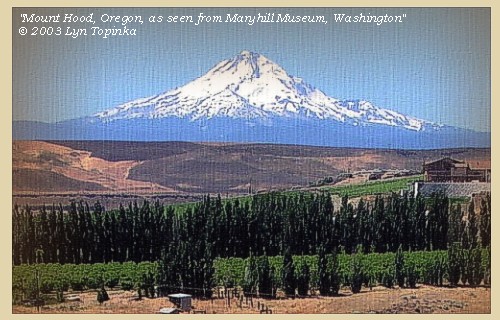
| We resumed our route, and soon after halted at a hill, from the top of which we enjoyed a commanding view of the range of mountains in which mount Hood stands, and which continue south as far as the eye can reach, with their tops covered with snow. mount Hood itself bears south 30? west, and the snowy summit of mount Jefferson south 10? west. |
| "... dureing the time the front of the party was waiting for Cap Lewis, I assended a high hill from which I could plainly See the range of Mountains which runs South from Mt. Hood as far as I could See. I also discovered the top of Mt. Jefferson which is Covered with Snow and is S 10o W. Mt. Hood is S. 30o W. the range of mountains are Covered with timber and also Mt. Hood to a sertain hite. The range of Mountains has Snow on them. ..." [Clark, April 22, 1806] |
| "... from the top of this emmenense Capt. C. had an extensive view of the country. he observed the range of mountains in which Mount Hood stands to continue nearly south as far as the eye could reach. he also observed the snow clad top of Mount Jefferson which boar S. 10 W. Mount Hood from the same point boar S. 30 W. the tops of the range of western mountains are covered with snow. ..." [Lewis, April 22, 1806] |
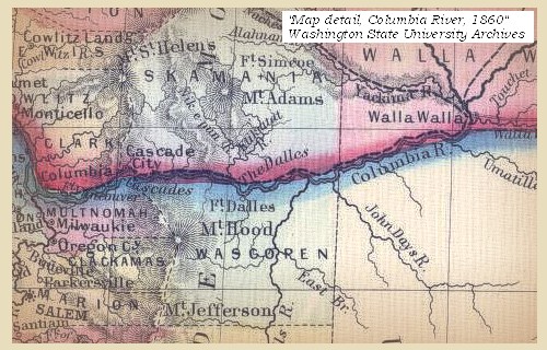
| Towards the south and at no great distance we discern some woody country, and opposite this point of view [Columbia Hills near Haystack Butte] is the mouth of the Towahnahiooks [Deschutes River]. This river receives, at the distance of eighteen or twenty miles, a branch from the right, which takes its rise in mount Hood, while the main stream comes in a course from the southeast; and ten or fifteen miles is joined by a second branch from mount Jefferson. |
| From this place we prceeded with our baggage in the centre, escorted both before and behind by those of the men who were without the care of horses, |
| Lewis and Clark are in the area of Maryhill, Washington. At this point the "Biggs Bridge" (U.S. Highway 97) spans the Columbia between Biggs Junction, Oregon, and Maryhill, a location which at one time was called "Five-Mile Rapids". Maryhill Museum, Maryhill State Park, and a reproduction of Stonehenge are located on the Washington side of the Columbia just off of the Highway 97 Bridge. |
|
|
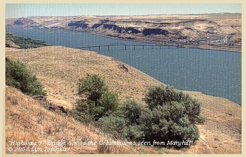
Five-Mile Rapids and U.S. Highway 97 Bridge: The Biggs Bridge, also known as U.S. Highway 97, is located 13.6 miles above The Dalles Dam, and has a clearance of 88 feet at the center of the fixed highway span. The bridge joins Maryhill, Washington, and Biggs Junction, Oregon. -- NOAA Office of Coast Survey Website, 2003 


Maryhill Museum: In 1907 Sam Hill, a wealthy entrepreneur bought 6,000 acres of land overlooking the Columbia River with the intention of establishing a Quaker agricultural community. He chose the bluff which Maryhill Museum now occupies as the site for his own home, and in 1914 construction of his poured concrete mansion began. He named both his home and his land company Maryhill after his daughter, Mary. On a promontory on the east side of the Museum's gardens are a series of interpretive panels that include journal entries written by William Clark while the Corps of Discovery stopped at sites visible from the Museum. One panel relates how Lewis and Clark walked across the plateau where the Museum sits during their return trip on April 22, 1806. -- Washington State Parks and Recreation Website, 2002 and Maryhill Museum Website, 2002 Maryhill State Park and Stonehenge Memorial: Maryhill State Park is a 99-acre camping park with 4,700 feet of waterfront on the Columbia River in Klickitat County. The area is significant for its natural beauty, its access to the surrounding natural wonders and its cultural history. A full-scale model of Stonehenge stands near the park. Maryhill's Stonehenge is the first monument in our nation to honor the dead of World War I. It was built by Sam Hill as a tribute to the soldiers of Klickitat County who lost their lives. The structure is a full-scale replica of England's famous neolithic Stonehenge. The monument lies at the original Maryhill townsite, four miles east of the museum, just off Washington Scenic Route 14. -- Washington State Parks and Recreation Website, 2002 and Maryhill Museum Website, 2002 |
| and having crossed a plain [Columbia Hills] eight miles in extent, reached a village of Eneeshurs, consisting of six houses. ...... [vicinity of today's John Day Dam]. |
| "... after Capt Lewis Came up we proceeded on through a open ruged plain about 8 miles to a Village of 6 Houses on the river here we observed our 2 Canoes passing up on the opposit Side and the Wind too high for them to join us. I halted at the mouth of a run [Moulton, vol.7, suggests it is perhaps Harley Canyon] above the village near Some good grass to let the horses graze and for the party to dine. ..." [Clark, April 22, 1806] |
| "... the high Smooth plain which is extensive & Smooth back from the river ... ..." [Ordway, April 22, 1806] |
|
|
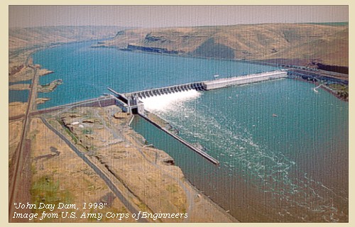
John Day Dam: The John Day Dam is located at the head of Lake Celilo, 216 miles upstream from the mouth of the Columbia River. The dam crosses the river near Rufus, Oregon, about 25 miles upstream from The Dalles, just below the mouth of the John Day River. To get to John Day Dam take exit 109 from Interstate 84. The project consists of a navigation lock, spillway, powerhouse and fish passage facilities on both shores. Construction began in 1958 and was completed in 1971, at a total cost of $511 million. At the time of it's completion, John Day Dam Powerhouse was the second largest in the world. Completion of the John Day Dam marked the final step in harnessing the lower waters of the Columbia River. Lake Umatilla, the reservoir behind the John Day Dam, extends approximately 76 miles upstream to the foot of McNary Dam. -- U.S. Army Corps of Engineers Website, 2002 


|
| went up the river four miles further, to another Eneeshur village of seven mat houses. Our guide now informed us that the next village was at such a distance that we should not reach it this evening, and as we should be able to procure both dogs and wood at this place, we determined to encamp [on the Washington side of the Columbia, across from the John Day River]. |
|
|
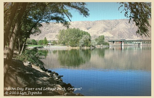
John Day River: The John Day River in northeastern Oregon contains over 500 river miles and is the second largest undammed tributary in the western United States, after the Yellowstone River. Its spring chinook salmon and summer steelhead populations are two of the last remaining intact wild populations of anadromous fish in the Columbia River basin. The John Day River has also been kept relatively free of hatchery influences. Many segments of the John Day River have been designated under the federal Wild Scenic Rivers Act and Oregon's State Scenic Waterways Act. Topographically, the John Day basin is an interior plateau bounded by the Columbia River to the north (Lake Umatilla), the Blue Mountains to the east, the Aldrich Mountains and Strawberry Range to the south, and the Ochoco Mountains to the west. The basin drains a large portion of northeast Oregon (nearly 8,100 square miles), flows 284 miles from its source in the Strawberry Mountains (9,000 feet), to its mouth at RM 217 on the Columbia River (200 feet). The John Day basin is characterized by diverse landforms ranging from loess-covered plateaus in the lower sections to glaciated alpine peaks in the headwaters. Elevations range from 200 feet at the mouth of the John Day River to over 9,000 feet in the Strawberry Mountains. Two major physiographic provinces exist in the John Day basin -- the Deschutes-Umatilla Plateau and the Blue Mountains. A third province, the Columbia Basin, is a minor province along the confluence with the Columbia River. -- Columbia Basin Fish and Wildlife Authority Website, 2002 


LePage Park, Oregon: LePage Park was named for expedition member private Jean LePage, whose name Lewis and Clark gave to today's John Day River. -- Lewis and Clark Bicentennial in Oregon Website, 2002 |
| We here purchased a horse, and engaged for a second in exchange for one of our canoes, but as they were on the opposite side of the river, and the wind very high, they were not able to cross before sunset, at which time the Indian had returned home to the next village above. ...... |
| "... after we proceeded on up the river about 4 miles to a village of 7 mat Lodges. here our Chopunnish guide informed me that the next villg. was at Some distance and that we Could not get to it to night, and that there was no wood to be precured on this Side. ... the air I find extreemly Cold which blows Continularly from Mt. Hoods Snowey regions. ... we made 14 miles to day with the greatest exirtion. ..." [Clark, April 22, 1806] |
|
|
|
The Camp - April 22, 1806:
Lewis and Clark's camp of April 22, 1806 was on the Washington side of the Columbia, across from the John Day River. |
| Home | Previous | Continue |
If you have questions or comments please contact: GS-CVO-WEB@usgs.gov
June/July 2004, Lyn Topinka
The Volcanoes of Lewis and Clark Home Page | CVO Home Page


