The Volcanoes of
Lewis and Clark
Lewis and Clark
|
April 18 - 20, 1806 Up the Columbia - The Dalles and the "Long Narrows" |
|
Home
The Volcanoes of Lewis and Clark Map of the Journey Volcanoes, Basalt Plateaus, Major Rivers, etc. The Volcanoes Mount Adams, Mount Hood, Mount Jefferson, Mount Rainier, and Mount St. Helens CALENDAR of the Journey October 1805 to June 1806 Along the Journey Pacific Northwest Maps - Columbia River, Volcanoes, Flood Basalts, Missoula Floods, Geology, etc. The Corps of Discovery The Journey of Lewis and Clark About the Reference Materials The Journals, Biddle/Allen, DeVoto, Gass, Moulton, Topo Maps, and others USGS Lewis and Clark Links Links to USGS Websites highlighting the Lewis and Clark Journey Resources Publications Referenced and Websites Visited |
PREVIOUS
April 16-17 Leaving the Gorge, Rock Fort and The Dalles |
April 18-20
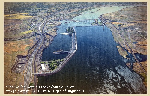
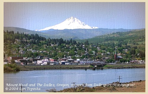
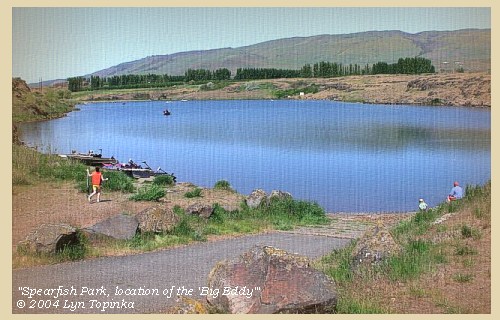
Up the Columbia, The Dalles and the "The Long Narrows" The Dalles Dam, Mount Hood, Spearfish Lake Park and "Big Eddy", Five-Mile Rapids and "The Long Narrows" |
CONTINUE
April 21 Up the Columbia, Celilo Falls to the Deschutes |
|
Heading for Home - April 1806
Up the Columbia - The Dalles and the "Long Narrows" |
| Lewis and Clark's "main" camp from April 15 through April 17 was at "Rock Fort", near Mill Creek, The Dalles, Oregon. |
| Friday, April 18, 1806 |
| We set out this morning after an early breakfast, and crossing the river, continued along the north side for four miles, to the foot of the first rapid [Three Mile Rapids, location of today's The Dalles Dam]. |
| Mount Hood creates a backdrop for The Dalles. |
| Here it was necessary to unload and make a portage of seven paces over a rock, round which we then drew the empty boats by means of a cord, and the assistance of setting poles. We then reloaded, and at the distance of five miles, reached the basin at the foot of the long narrows [Big Eddy, today the location near Spearfish Lake Park]. |
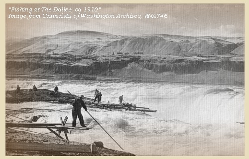
| After unloading and arranging the camp, we went up to the Skilloot village, where we found captain Clarke. He had not been able to procure more than four horses, for which he was obliged to give double the price of those formerly purchased from the Shoshonees and the first tribe of Flatheads. These, however, we hoped might be sufficient with the aid of the small canoes to convey our baggage as far as the villages near the Muscleshell rapid [Umatilla Rapids], where horses are cheaper and more abundant, and where we may probably exchange the canoes for as many horses as we want. ...... The long narrows have a much more formidable appearance than when we passed them in the autumn, so that it would, in fact, be impossible either to descend or go up them in any kind of boat. As we had therefore no further use for the two periogues, we cut them up for fuel. |
| "... Wood here is very scarce, as the Columbia plains have commenced. ..." [Gass April 18, 1806] |
|
|
|
The Camp - April 18, 1806:
Washington side of the Columbia, in the Big Eddy basin, two miles below the Skilloot Village. Today this location is just upstream of The Dalles Dam, near Spearfish Lake Park. |
| Saturday, April 19, 1806 |
| Early in the morning, all the party began to carry the merchandise over the portage [Five-Mile Rapids, also known as "The Long Narrows" or "The Dalles"]. This we accomplished with the aid of our four horses, by three o'clock in the afternoon, when we formed our camp a little above the Skilloot village. ...... |
| In the afternoon captain Clarke set out with four men for the Eneeshur village at the grand falls [Celilo Falls], in order to make further attempts to precure horses. |
| "... We deturmined to make the portage to the head of the long narrows, the 2 large canoes we could take no further and therefore cut them up for fuel. we had our small canoes drawn up very early and employed all hands in transporting our baggage on their backs and by means of 4 pack horses, over the porttage. This labour we had accomplished by 3. P.M. and established our camp a little above the present Skillute village. I left Capt L. at the bason and proceeded to the village early this morning with a view to receive the horses which were promised to be brought this morning for articles laid by last evining ... I set out with Serjt Pryor, Geo. Shannon Peter Crusat & Labiech at half past 5 P.M. for the Enesher village at which place I arrived at 8 P.M. Several showers of rain in the after part of to day, and thw S W wind very high. ..." The long narrows are much more formidable than they were when we decended them last fall, there would be no possibility of passing either up or down them in any vessle at this time ..." [Clark, April 19, 1806] |
|
|
|
The Camp - April 19 and April 20, 1806:
Washington side of the Columbia River, upstream of today's The Dalles Dam. Clark's Camp - April 19 and 20, 1806: Enesher Village |
| Sunday, April 20, 1806 |
| We now found that no more horses could be procured, and therefore prepared for setting out to-morrow. One of the canoes, for which the Indians would give us very little, we cut up for fuel, two others, together with some elk skins and pieces of old iron, we bartered for beads, and the remaining two small canoes were despatched early next morning with all the baggage which could not be carried on horseback. |
|
|
|
The Camp - April 19 and April 20, 1806:
Washington side of the Columbia River, upstream of today's The Dalles Dam. Clark's Camp - April 19 and 20, 1806: Enesher Village |
| Home | Previous | Continue |
If you have questions or comments please contact: GS-CVO-WEB@usgs.gov
June/July 2004, Lyn Topinka
The Volcanoes of Lewis and Clark Home Page | CVO Home Page


