The Volcanoes of
Lewis and Clark
Lewis and Clark
|
April 16 - 17, 1806 Leaving the Gorge - Rock Fort and The Dalles |
|
Home
The Volcanoes of Lewis and Clark Map of the Journey Volcanoes, Basalt Plateaus, Major Rivers, etc. The Volcanoes Mount Adams, Mount Hood, Mount Jefferson, Mount Rainier, and Mount St. Helens CALENDAR of the Journey October 1805 to June 1806 Along the Journey Pacific Northwest Maps - Columbia River, Volcanoes, Flood Basalts, Missoula Floods, Geology, etc. The Corps of Discovery The Journey of Lewis and Clark About the Reference Materials The Journals, Biddle/Allen, DeVoto, Gass, Moulton, Topo Maps, and others USGS Lewis and Clark Links Links to USGS Websites highlighting the Lewis and Clark Journey Resources Publications Referenced and Websites Visited |
PREVIOUS
April 15 Columbia River Gorge, Major Creek to The Dalles |
April 16-17
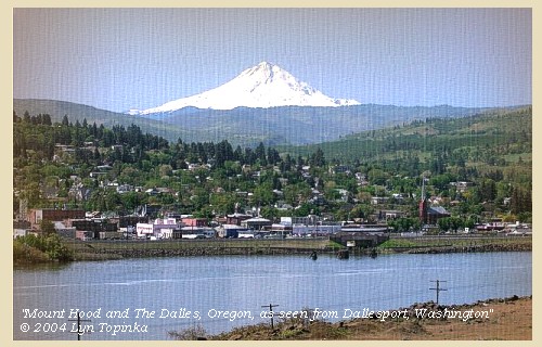
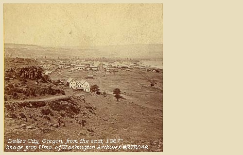
Leaving the Gorge, Rock Fort and The Dalles Rock Fort, Mount Hood, The Submerged Forest, The Dalles (Oregon) |
CONTINUE
April 18-20 Up the Columbia, The Dalles and the "Long Narrows" |
|
Heading for Home - April 1806
Leaving the Gorge - Rock Fort and The Dalles |
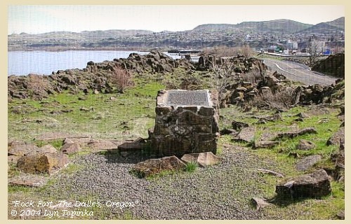
| Lewis and Clark's "main" camp from April 15 through April 17 was at "Rock Fort", near Mill Creek, The Dalles, Oregon. |
| Wednesday, April 16, 1806 |
| In the morning, Captain Clarke crossed with nine men [to the Washington side], and a large part of the merchandise, in order to purchase twelve horses to transport our baggage, and some pounded fish, as a reserve during the passage of the Rocky mountains. The rest of the men were employed in hunting and preparing saddles [at Rock Fort, The Dalles, Oregon]. |
| From the rapids [Bonneville/Cascade Locks] to this place [Rock Fort, The Dalles, Oregon], and indeed as far as the commencement of the narrows, the Columbia is from half a mile to three quarters in width, and possesses scarcely any current: its bed consists principally of rock, except at the entrance of Labiche river [Hood River], which takes its rise in mount Hood, from which, like Quicksand river [Sandy River], it brings down vast quantities of sand. |
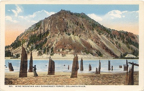
| During the whole course of the Columbia from the Rapids [Bonneville/Cascade Locks area] to the Chilluckittequaws [White Salmon area] are the trunks of many large pine trees standing erect in water, [Submerged Forest] which is thirty feet deep at present, and never less than ten. These trees could never have grown in their present state, for they are all very much doated, and none of them vegetate; so that the only reasonable account which can be given of this phenomenon, is, that at some period, which the appearance of the trees induces us to fix within twenty years, the rocks from the hill sides have obstructed the narrow pass at the rapids, and caused the river to spread through the woods. |
| The mountains which border as far as the Sepulchre rock [Memaloose Island], are high and broken, and its romantic views accasionally enlivened by beautiful cascades rushing from the heights, and forming a deep contrast with the firs, cedars and pines, which darken their sides. From the Sepulchre rock [Memaloose Island], where the low country begins, the long-leafed pine is the almost exclusive growth of timber; but our present camp [Rock Fort, The Dalles, Oregon] is the last spot where a single tree is to be seen on the wide plains, which are now spread before us to the foot of the Rocky mountains [beginning of the Columbia River Plateau]. It is, however, covered with a rich verdure of grass and herbs, some inches in height, which forms a delightful and exhilarating prospect, after being confined to the mountains and thick forests on the seacoast. The climate too, though only on the border of the plains, is here very different from that we have lately experienced. The air is drier and more pure, and the ground itself is as free from moisture as if there had been no rain for the last ten days. ...... |
|
Captain Clarke had, in the meantime, been endeavouring to purchase horses, without success, but they promised to trade with him if he would go up to the Skilloot village, above the long narrows. He therefore sent over to us for more merchandise, and then accompanied them in the evening to that place, where he passed the night. |
| "... About 8 oClock this morning I passed the river with the two interpreters, and nine men in order to trade with the nativs for their horses ... Capt L. sent out the hunters and set several men at work makeing pack saddles ... I formed a Camp on the N. Side and sent Drewyer & Goodrich to the Skillute Village, and Shabono & Frazer down to the Chilluckkitequaw Village with derections to inform the nativs that I had crossed the river for the purpose of purchaseing horses ..." [Clark, April 16, 1806] |
|
|
|
The Main Camp - April 15 through April 17, 1806:
Lewis and Clark's set up camp at "Rock Fort", The Dalles, Oregon. Clark's Camp, April 16, 1806: |
| Thursday, April 17, 1806 |
| He [Captain Clark] sent to inform us that he was still unable to purchase any horses, but intended going as far as the Eneeshur village to-day, whence he would return to meet us to-morrow at the Skilloot village. In the evening the principal chief of the Chilluckittequaws came to see us, accompanied by twelve of his nation, and hearing that we wanted horses, he promised to meet us at the narrows with some for sale. |
| "... I rose early after bad nights rest and took my merchindize to a rock which afforded an eligable situation for my purpose ... before precureing the 3 horses I dispatched Crusat, Willard & McNeal and Peter Wiser to Capt Lewis at the Rock fort Camp with a note informing him of my ill suckcess in precureing horses, and advised him to proceed on to this place as soon as possible. that I would in the mean time proceed on to the Enesher National above the Great falls ... in the evening I recved a note from Capt L. by Shannon informing me that he should set out early on tomorrow morning and should proceed up to the bason 2 miles below the Skillute Village ... [Clark, April 17, 1806] |
|
|
|
The Main Camp - April 15 through April 17, 1806:
Lewis and Clark's set up camp at "Rock Fort", The Dalles, Oregon. Clark's Camp, April 17, 1806: |
| Home | Previous | Continue |
If you have questions or comments please contact: GS-CVO-WEB@usgs.gov
June/July 2004, Lyn Topinka
The Volcanoes of Lewis and Clark Home Page | CVO Home Page


