|
April 9, 1806 Columbia River Gorge - Shepperd's Dell to Bonneville |
|
Home
The Volcanoes of Lewis and Clark Map of the Journey Volcanoes, Basalt Plateaus, Major Rivers, etc. The Volcanoes Mount Adams, Mount Hood, Mount Jefferson, Mount Rainier, and Mount St. Helens CALENDAR of the Journey October 1805 to June 1806 Along the Journey Pacific Northwest Maps - Columbia River, Volcanoes, Flood Basalts, Missoula Floods, Geology, etc. The Corps of Discovery The Journey of Lewis and Clark About the Reference Materials The Journals, Biddle/Allen, DeVoto, Gass, Moulton, Topo Maps, and others USGS Lewis and Clark Links Links to USGS Websites highlighting the Lewis and Clark Journey Resources Publications Referenced and Websites Visited |
PREVIOUS
April 6-8 Columbia River Gorge, Cottonwood Beach Camp to Shepperd's Dell |
April 9
Columbia River Gorge, Shepperd's Dell to Bonneville Cape Horn, Multnomah Falls, Lava Flows and Gorge Waterfalls, Beacon Rock and Beacon Rock State Park, Hamilton Island, Bradford Island, Bonneville Dam |
CONTINUE
April 10-11 Columbia River Gorge, Bonneville Vicinity |
On October 7, 1805, Lewis and Clark and the
"Corps of Discovery" began their journey
down the Clearwater River and into the volcanics
of the Pacific Northwest. The Corps travelled from the
Clearwater to the Snake and down the
"Great Columbia", finally reaching the
Pacific Ocean on November 15, 1805.
Along the journey they encountered the
lava flows of the Columbia Plateau,
river channels carved by the great "Missoula Floods",
and the awesome beauty of five Cascade Range volcanoes.

[Click map for brief summary about the area] |
|
Heading for Home - April 1806
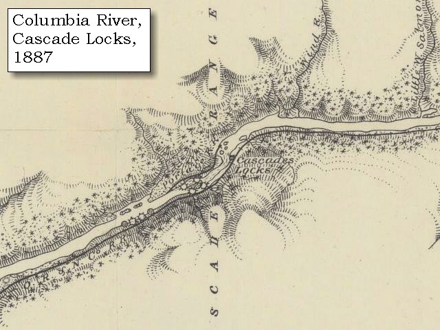
Columbia River Gorge - Shepperd's Dell to Bonneville |
| Lewis and Clarks camp from April 6 through April 8, 1806, was in the area of today's Shepperd's Dell State Park, Oregon. |
| Wednesday, April 9, 1806 |
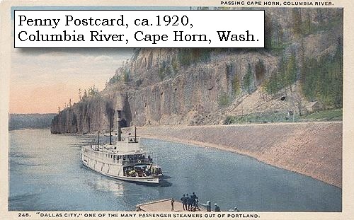
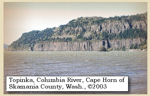
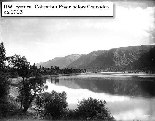
| The wind having moderated, we reloaded the canoes, and set out by seven o'clock. We stopped to take up two hunters who had left us yesterday, but were unsuccessful in the chase, and then proceeded to the Wahclellah village, situated on the north side of the river, about a mile below Beacon rock. [Beacon Rock] During the whole of the route from our camp, we passed along under high, steep, and rocky sides of the mountains, which now close on each side of the river, forming stupendous precipices [Cape Horn is on the Washington side], covered with the fir and white cedar. |
|
|
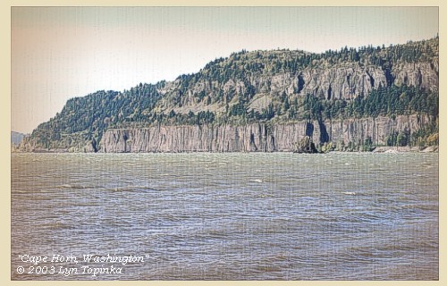
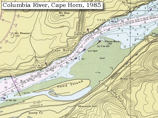
Cape Horn: Flows of Grande Ronde Basalt of the Columbia River Basalt Group form the steep cliffs of Cape Horn, with Troutdale formation gravels capping the basalt unconformably. The gravels in turn are overlain by lavas of the small Mount Zion olivine basalt shield, of the Boring Lava Field. -- Norman and Roloff, 2004, Washington State DNR Open-File Report 2004-7. 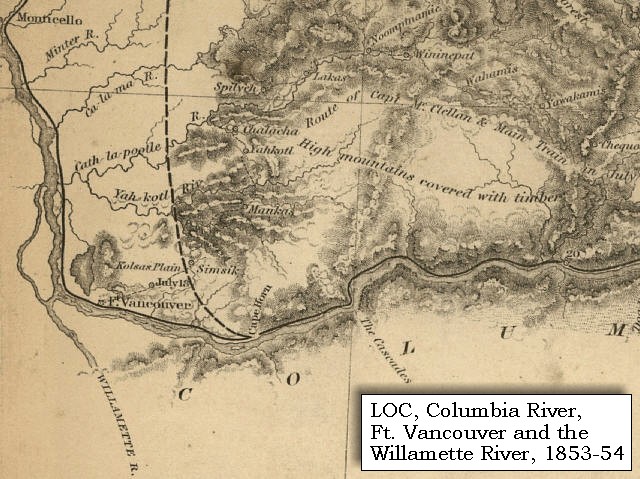


|
| Down these heights frequently descend the most beautiful cascades, one of which a large creek, throws itself over a perpendicular rock three hundred feet above the water, while other smaller streams precipitate themselves from a still greater elevation, and evaporating in a mist, again collect and form a second cascade before they reach the bottom of the rocks [Multnomah Falls ???]. We stopped to breakfast at this village. ...... |
|
|
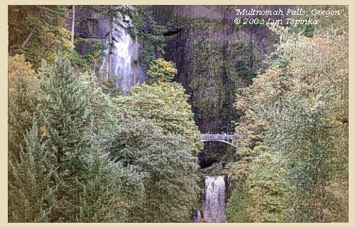
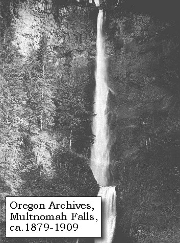
Multnomah Falls: Multnomah Falls, plummeting 620 feet from its origins on Larch Mountain, is the second highest year-round waterfall in the United States. Nearly two million visitors a year come to see this ancient waterfall making it Oregon's number one public destination. Fed by underground springs from Larch Mountain, the flow over the falls varies usually being highest during winter and spring. Multnomah Falls offers one of the best places in the Columbia River Gorge National Scenic Area to study geology exposed by floods. Five flows of Yakima basalt are visible in the fall's cliff face. The two falls are produced because of a more easily eroded zone at the base of the upper falls. -- U.S. Forest Service Website, 2002, and Beeson and Tolan, 1987 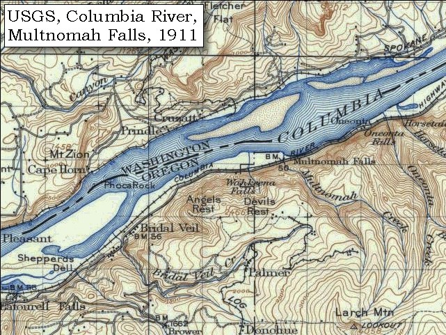
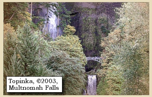
Lava Flows and the Gorge Waterfalls: The presence of prominent vertical cooling joints in most of the lava flows, combined with the weak interflow zones result in steep cliffs and abundant waterfalls. Observations of waterfalls occurring over Columbia River basalt flows have shown that falls often occur where flows are flat lying or dipping upstream. This condition allows blocks produced by vertical cooling joints to be stable until support is withdrawn by erosion of the weaker interflow material at the base of the flows. The rate of erosion of interflow material probably largely controls the rate of retreat of the falls. The amphitheater-shaped valley common to many of the falls within the gorge is due to freeze-thaw action of water from splash mist that penetrates the joints. Most waterfalls are limited to the Oregon side of the Columbia River Gorge because landslides modify the steepness on the Washington side. The entire region's bedrock material is tilted slightly southward. When it is water saturated, the upper basaltic layers on the north side of the river slide into the Gorge. Thus, waterfalls on the Washington side are fewer and smaller. -- Beeson and Tolan, 1987 |
| As these people had been very kind to us as we descended the river, we endeavoured to repay them by every attention in our power. After purchasing, with much difficulty, a few dogs and some wappatoo from the Wahclellahs, |
| "... a large creek puts in close above the village which we did not discover last fall [Woodward Creek ???] . when we passd down we dined and proceed. on ..." [Ordway, April 9, 1806] |
| we left them at two o'clock, and passing under the Beacon rock [Beacon Rock], reached in two hours the Clahcellah village. This Beacon rock, which we now observed more accurately than as we descended, stands on the north side of the river, insulated from the hills. The northern side has a partial growth of fir or pine. To the south it rises in an unbroken precipice to the height of seven hundred feet, where it terminates in a sharp point, and may be seen at the distance of twenty miles below. This rock may be considered as the commencement of tide-water, though the influence of the tide is perceptible here in autumn only, at which time the water is low. What the precise difference at those seasons is, we cannot determine; but on examining a rock which we lately passed, and comparing its appearance now with that which we observed last November, we judge the flood of this spring to be twelve feet above the height of the river at that time. From Beacon rock as low as the marshy islands [area of Lewis and Clark National Wildlife Refuge, near the mouth of the Columbia], the general width of the river is from one to two miles, though in many places it is still greater. ...... |
| "... this remarkable rock which stands on the North shore of the river is unconnected with the hills and rises to the hight of seven hundred feet; it has some pine or reather fir timber on it's nothern side, the southern is a precipice of it's whole hight. it rises to a very sharp point and is visible for 20 miles below on the river ..." [Lewis, April 6, 1806] |
| "... at 2 oClock P. M. we set out and passed under the Beacon rock on the North Side of two small Islds. situated nearest the N. side [Two islands of today are Pierce Island and Ives Island.] ..." [Clark, April 9, 1806] |
|
|
|
Beacon Rock and Beacon Rock State Park: Beacon Rock is an eroded olivine basalt plug that rises 840 feet above river level. The ice-age floods through the Columbia River Gorge eroded the softer material away, leaving this unique geological structure standing by itself on the northern bank of the Columbia River. This basalt monolith is second in size only to the Rock of Gibraltar. "Beacon Rock" was originally named by Lewis and Clark on their expedition to the Pacific Ocean, altho in Clark's journal he calls it "Beaton Rock", a spelling which was corrected by Lewis and also corrected in the Biddle/Allen publication of 1814. It was near Beacon Rock that they first measured tidal influences from the ocean on the Columbia River. In 1811, Alexander Ross of the John Jacob Astor expedition called the rock "Inoshoack Castle." The rock was known as "Castle Rock" until 1916 when the United States Board of Geographic Names restored the name "Beacon Rock". Henry J. Biddle (an heir of Nicholas Biddle, editor of the 1814 journals) purchased the rock, built a trail to the top, and in 1935 his heirs turned the rock over to the state for use as a park. Additional development was done by the Civilian Conservation Corps. Today, Beacon Rock stands at the head of Washington State's Beacon Rock State Park. -- Norman and Roloff, 2004, Washington State DNR Open-File Report 2004-7, Washington State Historical Society Website, 2004, "Lasting Legacy", and Washington State Parks and Recreation Website, 2001. 
|
| As our large canoes could not ascend the rapids on the northside we passed to the opposite shore, and entered the narrow channel which separates it from Brant island [Bradford Island]. |
| "... at 4 P. M. we arived at the first rapid at the head of Strawberry island at which place on the N W. Side of the Columbia here we found the nativs from the last village rebuilding their habitations of the bark of their old village ... as we could not pass with the large canoes up the N.W. Side for the rocks, the wind high and a rainey disagreeable evining. our smallest canoe being too low to cross through the high waves, we sent her up on the N W. Side with Drewyer and the two Fields and after purchaseing 2 dogs crossed and into the sluce of a large high Island seperated from the S.E. Side by a narrow channel. in this chanel we found a good harbor and encamped on the lower side. evening wet & disagreeable ..." [Clark, April 9, 1806] |
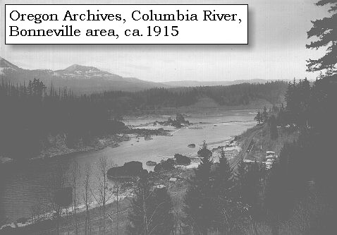
| Lewis and Clark have passed "Strawberry Island" (Hamilton Island), and reached Bradford Island, the area of today's Bonneville Dam, and camped on the Oregon side of the Columbia behind Bradford Island, upstream of Tanner Creek and across from the downstream tip of Bradford Island. |
|
|
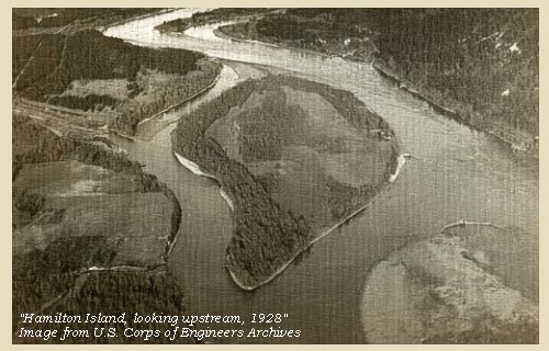
Hamilton Island: Lewis and Clark called this island "Strawberry Island", as it seemed to be cultivated with woodland strawberry vines. The physiography of Hamilton Island has changed greatly since Lewis and Clark's time with the construction of Bonneville Dam. -- Washington State Historical Society Website, 2004, "Lasting Legacy" 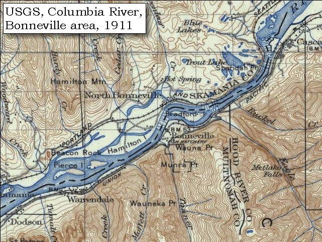

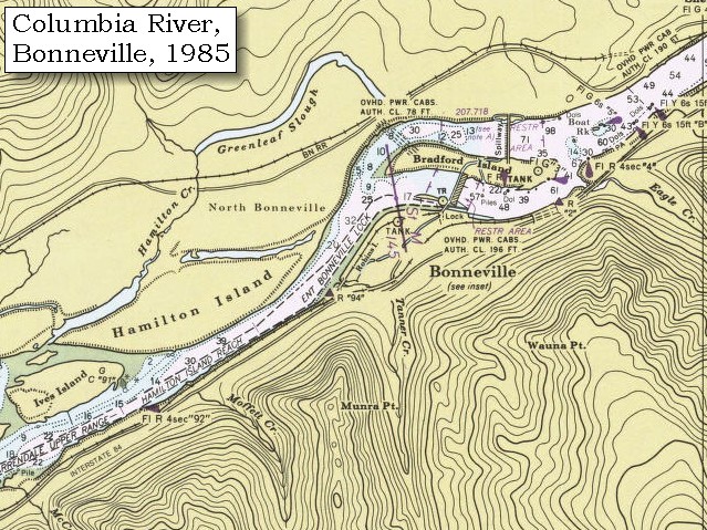
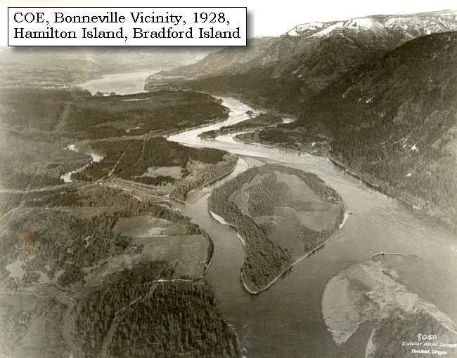
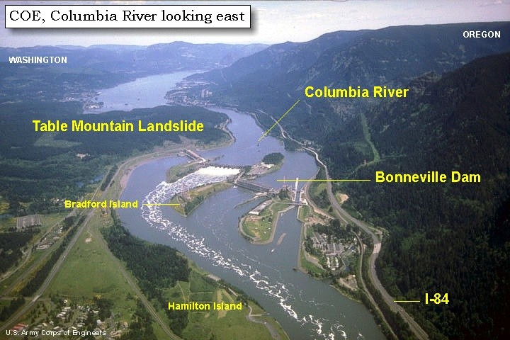
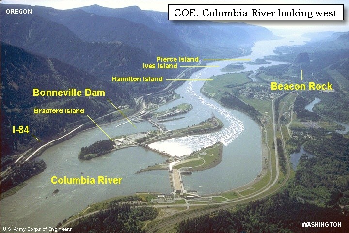
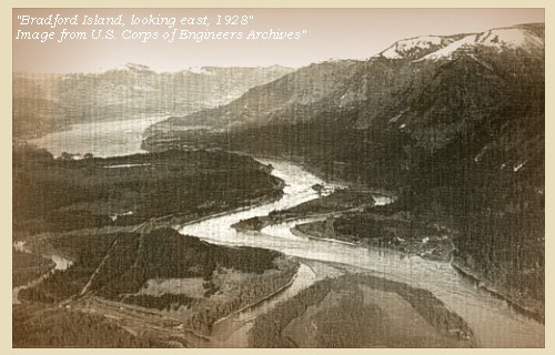
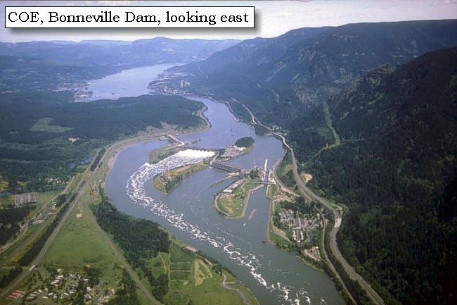
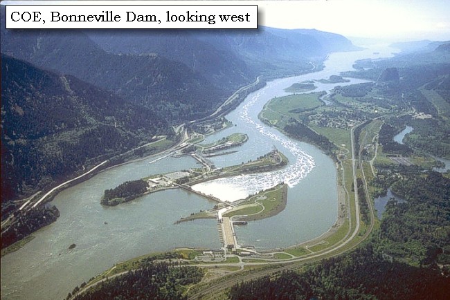
Bradford Island: Bradford Island was once an old Indian burial ground in the middle of the Columbia River. The island now is part of the Bonneville Dam structure. Lewis and Clark called the island "Brant Island", and was so named because of the large flocks of Lesser Canadian Geese observed in the vicinity. Returning eastbound in 1806, the corps stopped on the island to dine prior to heading to the southern mainland to camp before attempting the portage of the "Grand Rapids." The south end of Bonneville Dam is presently on the island, now named for the Bradford brothers, who operated steamboats on the river. -- Center for Columbia River History Website, 2004, and Washington State Historical Society Website, 2004, "Lasting Legacy". 
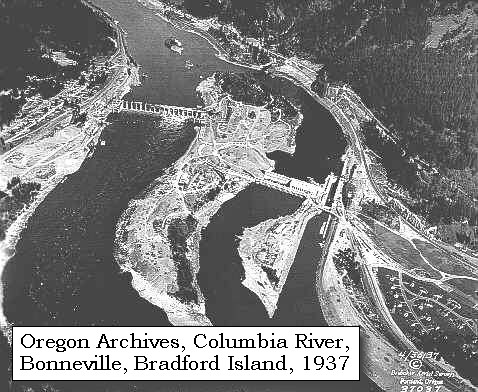
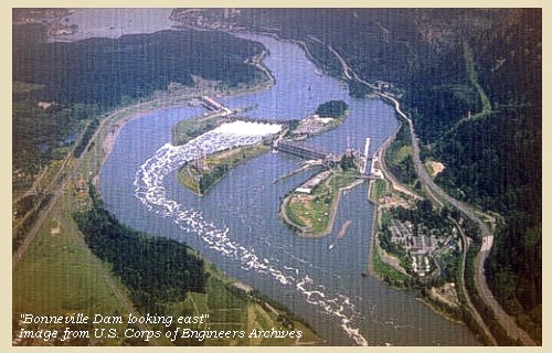
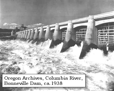
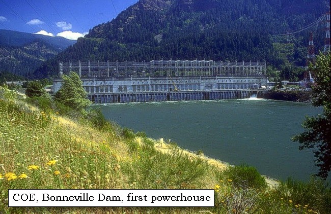
Bonneville Dam: Bonneville Lock and Dam and Lake Bonneville are in the Columbia River Gorge, one of the most scenic areas in the Pacific Northwest. The walls of the gorge rise 2,000 feet above Lake Bonneville in many places and can be seen from any of the 10 recreation areas around the reservoir. Bonneville Dam spans the Columbia River from Oregon to Washington, a distance of 1,100 feet. Bradford Island, an old Indian burial ground separating the river's two channels, is at the center of the mammoth barrier. Bonneville Dam was begun in 1933 and completed in 1938, and was the first of the major power dams on the Columbia. The dam is a 1,230-foot-long gravity-type, concrete spillway dam across the center channel of the Columbia River and measures 180 feet wide at its base. It has two 350-ton gantry cranes which operate from a service roadway 99 feet above the water, to regulate the 18 movable-crest steel gates. The project required 750,000 cubic of concrete. It cost $88.4 million to build the spillway dam on one side of Bradford Island, a powerhouse, and navigation locks on the other side of the island. The Bonneville Power Administration added a second powerhouse in the 1980s and dug a channel through Bradford Island. Bonneville Dam was named for Captain Benjamin de Bonneville. -- U.S. Army Corps of Engineers Website, 2004, Oregon State Archives Website, 2002, and Center for Columbia River History Website, 2004
|
| The weather was very cold and rainy, and the wind so high, that we were afraid to attempt the rapids this evening, and therefore, finding a safe harbour, we encamped for the night [on the Oregon side of the Columbia across from the downstream tip of Bradford Island.]. ...... |
|
|
|
The Camp - April 9, 1806:
Lewis and Clark camped on the Oregon side of the Columbia River, at a location now near the Bonneville Dam, upstream of Tanner Creek and across from the downstream tip of Bradford Island. |
| Home | Previous | Continue |
If you have questions or comments please contact: GS-CVO-WEB@usgs.gov
June/July 2004, Lyn Topinka
The Volcanoes of Lewis and Clark Home Page | CVO Home Page