The Volcanoes of
Lewis and Clark
April 10 - 11, 1806
Columbia River Gorge - Bonneville Vicinity
 
Home
The Volcanoes of Lewis and Clark

Map of the Journey
Volcanoes, Basalt Plateaus, Major Rivers, etc.

The Volcanoes
Mount Adams, Mount Hood, Mount Jefferson, Mount Rainier, and Mount St. Helens

CALENDAR of the Journey
October 1805 to June 1806

Along the Journey
Pacific Northwest Maps - Columbia River, Volcanoes, Flood Basalts, Missoula Floods, Geology, etc.

The Corps of Discovery
The Journey of Lewis and Clark

About the Reference Materials
The Journals, Biddle/Allen, DeVoto, Gass, Moulton, Topo Maps, and others

USGS Lewis and Clark Links
Links to USGS Websites highlighting the Lewis and Clark Journey

Resources
Publications Referenced and Websites Visited


PREVIOUS

April 9
Columbia River Gorge, Cottonwood Beach Camp to Bonneville
April 10-11

Columbia River Gorge,
Bonneville Vicinity

Bradford Island, Bonneville Dam, Bonneville Landslide
CONTINUE

April 12
Columbia River Gorge, "Lower Falls of the Columbia", Cascade Locks
 

On October 7, 1805, Lewis and Clark and the "Corps of Discovery" began their journey down the Clearwater River and into the volcanics of the Pacific Northwest. The Corps travelled from the Clearwater to the Snake and down the "Great Columbia", finally reaching the Pacific Ocean on November 15, 1805. Along the journey they encountered the lava flows of the Columbia Plateau, river channels carved by the great "Missoula Floods", and the awesome beauty of five Cascade Range volcanoes.

Map, Lewis and Clark in the Pacific Northwest, click for brief
                         summary
[Click map for brief summary about the area]


Heading for Home - April 1806
Columbia River Gorge - Bonneville Vicinity
 

Lewis and Clark's camp of April 9, 1806, was on the Oregon side of the Columbia River, at a location now near the Bonneville Dam, upstream of Tanner Creek and across from the lower tip of Bradford Island.

Thursday, April 10, 1806
Early in the morning we dropped down the channel to the lower end of Brant island [Bradford Island], and then drew our boats up the rapid.


Along the Journey - April 10, 1806
Bradford Island

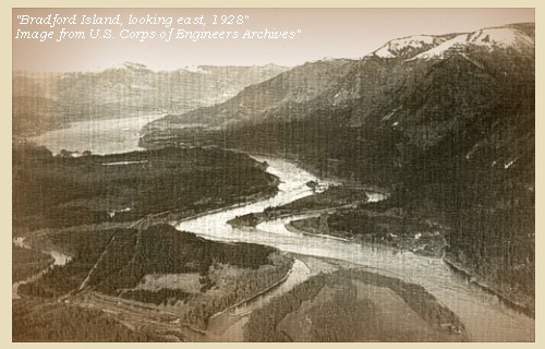
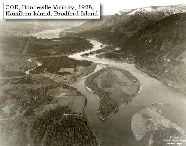
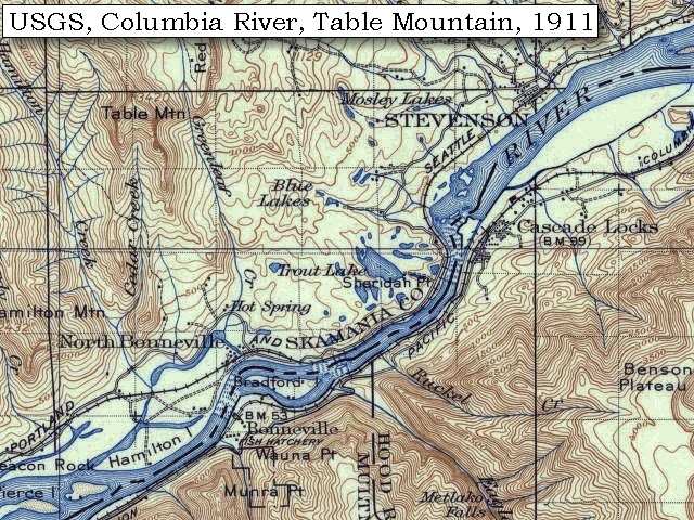
Bradford Island:
Bradford Island was once an old Indian burial ground in the middle of the Columbia River. The island now is part of the Bonneville Dam structure. Lewis and Clark called the island "Brant Island", and was so named because of the large flocks of Lesser Canadian Geese observed in the vicinity. Returning eastbound in 1806, the corps stopped on the island to dine prior to heading to the southern mainland to camp before attempting the portage of the "Grand Rapids." The south end of Bonneville Dam is presently on the island, now named for the Bradford brothers, who operated steamboats on the river. -- Center for Columbia River History Website, 2004, and Washington State Historical Society Website, 2004, "Lasting Legacy".


Map, 1814, Lower Falls of the Columbia, click to enlarge Map, 1911 USGS topo map of the Bonneville area, click to enlarge Map, 1948, Bonneville Dam, Hamilton Island, Bradford Island, click to enlarge Map, 1985, Bonneville Vicinity, click to enlarge Image, 1928, Columbia River and Hamilton and Bradford Islands, click to enlarge Image, 1937, Columbia River and Bradford Island, click to enlarge Image, Aerial view, Bonneville Dam, looking east, annotated, click to enlarge Image, Aerial view, Bonneville Dam, looking west, annotated, click to enlarge
  1. 1814 Map, Lower Falls of the Columbia, by Lewis and Clark. (Click to enlarge). Brant Island is in the location of Bradford Island. This map is found in Travels to the source of the Missouri River and across the American continent to the Pacific Ocean : performed by order of the government of the United States, in the years 1804, 1805, and 1806, by Captains Lewis and Clarke. Published from the official report, 1814. -- University of Washington Library Collections Website, 2002
  2. 1911 Map (section of original), from Mount Hood and Vicinity 1:125,000 topographic quadrangle. (Click to enlarge). Original map surveyed in 1907 and 1909-1911, contour interval of 100 feet. -- University of Washington Library Collections Website, 2002
  3. 1948 Map (section of original), Bonneville area including Bonneville, Bonneville Dam, Hamilton Island, and Bradford Island. (Click to enlarge). Office of Coast Surveys, Historical Maps and Charts, Columbia River, Vancouver to Bonneville, 1948, Chart#6156, 1:40,000. -- NOAA Office of Coast Survey Website, 2004
  4. 1985 Map (section of original), Bonneville Vicinity, including Hamilton Island, Bradford Island, and Bonneville Dam. (Click to enlarge). Office of Coast Surveys, Historical Maps and Charts, Columbia River, Vancouver to Bonneville, 1985, Chart#18531, 1:40,000. -- NOAA Office of Coast Survey Website, 2004
  5. 1928, Columbia River, Hamilton and Bradford Islands, and vicinity, prior to the construction of the Bonneville Lock and Dam. (Click to enlarge). View is looking upstream with Washington State on the left and Oregon on the right. The Bonneville Landslide is prominent jutting into the Columbia River from the Washington side (upper third of photo). Hamilton Island is the big island in the foreground and Bradford Island is across from the Bonneville Landslide. U.S. Corps of Engineers Historical Archives #700-64. Photograph Date: April 11, 1928. -- U.S. Army Corps of Engineers Website, 2002
  6. 1937, Bradford Island and the construction Bonneville Dam on the Columbia River. (Click to enlarge). Oregon State Archives, Oregon Department of Transportation #OHDM004. Photograph Date: April 1937, Photographer: Brubaker Aerial Surveys. -- Oregon State Archives Website, 2002
  7. Aerial view, Columbia River and Bonneville Dam, looking east, annotated. (Click to enlarge). Washington State is on the left with a good view of the Bonneville Landslide jutting into the Columbia River. Oregon is on the right. Bradford Island is crossed by the Bonneville Dam. Hamilton Island is in the foreground. Annotation includes Columbia River, Bonneville Dam, Interstate 84, Bonneville Landslide, Hamilton Island, and Bradford Island. -- U.S. Army Corps of Engineers Website, 2003
  8. Aerial view, Columbia River and Bonneville Dam, looking west, annotated. (Click to enlarge). Oregon is on the left and Washington State is on the right. Includes annotation for the Columbia River, Bonneville Dam, I-84, Bradford Island, Hamilton Island, Ives Island, Pierce Island, and Beacon Rock. -- U.S. Army Corps of Engineers Website, 2003


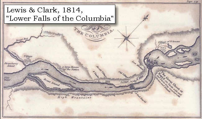
At the distance of a quarter of a mile we crossed over to a village of Clahclellahs, consisting of six houses, on the opposite side [Washington side, east of North Bonneville, location of the Bonneville Dam]. The river is here about four hundred yards wide, and the current so rapid, that although we employed five oars for each canoe, we were borne down a considerable distance. ......


Along the Journey - April 10, 1806
Bonneville Dam

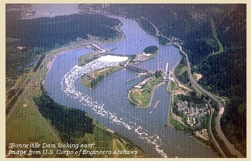
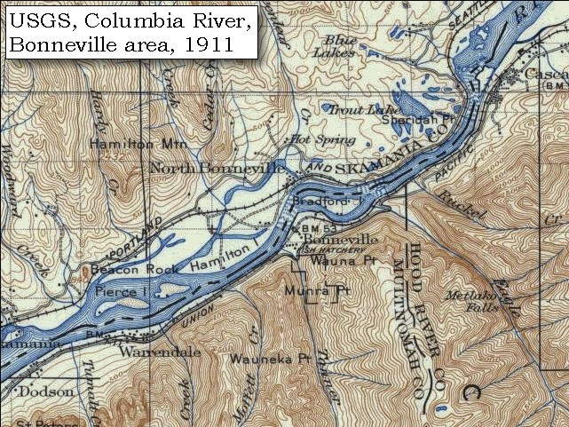
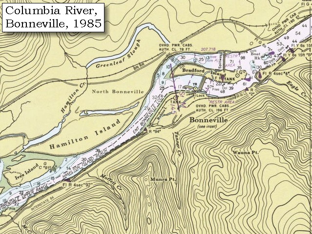
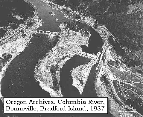
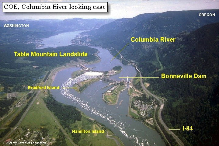
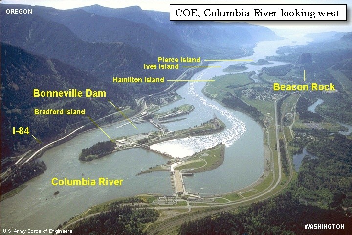
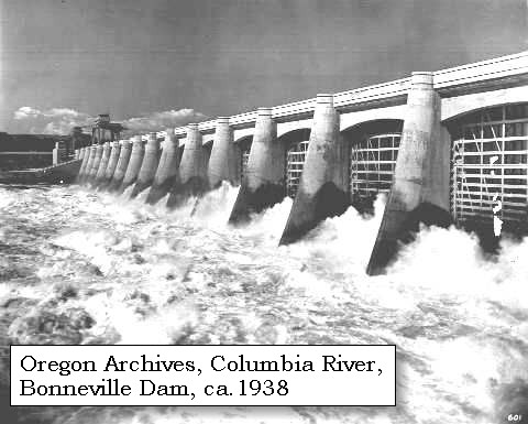
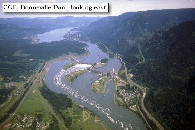
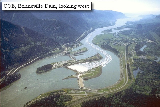
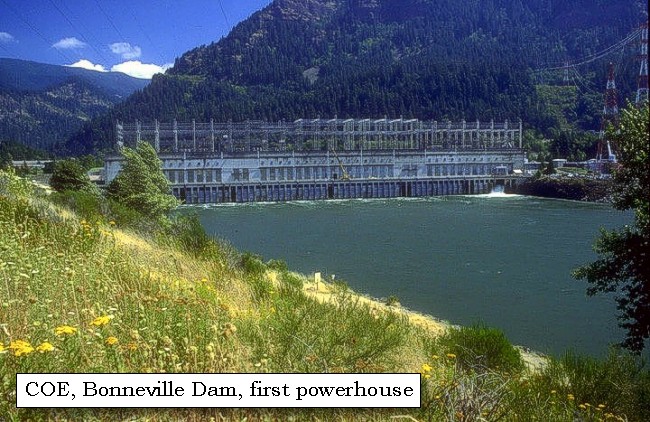
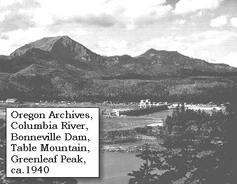
Bonneville Dam:
Bonneville Lock and Dam and Lake Bonneville are in the Columbia River Gorge, one of the most scenic areas in the Pacific Northwest. The walls of the gorge rise 2,000 feet above Lake Bonneville in many places and can be seen from any of the 10 recreation areas around the reservoir. Bonneville Dam spans the Columbia River from Oregon to Washington, a distance of 1,100 feet. Bradford Island, an old Indian burial ground separating the river's two channels, is at the center of the mammoth barrier. Bonneville Dam was begun in 1933 and completed in 1938, and was the first of the major power dams on the Columbia. The dam is a 1,230-foot-long gravity-type, concrete spillway dam across the center channel of the Columbia River and measures 180 feet wide at its base. It has two 350-ton gantry cranes which operate from a service roadway 99 feet above the water, to regulate the 18 movable-crest steel gates. The project required 750,000 cubic of concrete. It cost $88.4 million to build the spillway dam on one side of Bradford Island, a powerhouse, and navigation locks on the other side of the island. The Bonneville Power Administration added a second powerhouse in the 1980s and dug a channel through Bradford Island. Bonneville Dam was named for Captain Benjamin de Bonneville. -- U.S. Army Corps of Engineers Website, 2004, Oregon State Archives Website, 2002, and Center for Columbia River History Website, 2004


Map, 1814, Lower Falls of the Columbia, click to enlarge Map, 1887, Cascade Locks vicinity, click to enlarge Map, 1911 USGS topo map of the Bonneville area, click to enlarge Map, 1948, Bonneville Dam, Hamilton Island, Bradford Island, click to enlarge Map, 1985, Bonneville Vicinity, click to enlarge Image, ca.1913, Columbia River, Bonneville vicinity, click to enlarge Image, ca.1915, Columbia River at Bonneville, click to enlarge Image, 1938, Bonneville Dam, click to enlarge Aerial view, Bonneville Dam, looking east, click to enlarge Image, Aerial view, Bonneville Dam, looking east, annotated, click to enlarge Aerial view, Bonneville Dam, looking west, click to enlarge Image, Aerial view, Bonneville Dam, looking west, annotated, click to enlarge Aerial view, Bonneville Dam, first powerhouse, looking east, click to enlarge
  1. 1814 Map, Lower Falls of the Columbia, by Lewis and Clark. (Click to enlarge). This map is found in Travels to the source of the Missouri River and across the American continent to the Pacific Ocean : performed by order of the government of the United States, in the years 1804, 1805, and 1806, by Captains Lewis and Clarke. Published from the official report, 1814. -- University of Washington Library Collections Website, 2002
  2. 1887 Map (section of original), Columbia River and the Cascade Locks vicinity. (Click to enlarge). Original Map: The Columbia River from Celilo to the mouth showing locations of the salmon fisheries, 1887. Scale ca. 1:375,000, Relief shown by hachures. U.S. Army Corps of Engineers, Engineer Office, G.P.O. 1888. University of Washington Archives #UW128. -- University of Washington Library Archives Website, 2002
  3. 1911 Map (section of original), from Mount Hood and Vicinity 1:125,000 topographic quadrangle. (Click to enlarge). Original map surveyed in 1907 and 1909-1911, contour interval of 100 feet. -- University of Washington Library Collections Website, 2002
  4. 1948 Map (section of original), Bonneville area including Bonneville, Bonneville Dam, Hamilton Island, and Bradford Island. (Click to enlarge). Office of Coast Surveys, Historical Maps and Charts, Columbia River, Vancouver to Bonneville, 1948, Chart#6156, 1:40,000. -- NOAA Office of Coast Survey Website, 2004
  5. 1985 Map (section of original), Bonneville Vicinity, including Hamilton Island, Bradford Island, and Bonneville Dam. (Click to enlarge). Office of Coast Surveys, Historical Maps and Charts, Columbia River, Vancouver to Bonneville, 1985, Chart#18531, 1:40,000. -- NOAA Office of Coast Survey Website, 2004
  6. 1913, Columbia River, Bonneville vicinity, below the cascades. (Click to enlarge). Photo by Albert Henry Barnes, ca.1913. University of Washington A.H. Barnes Collection #BAR021. -- University of Washington Library Archives, 2003
  7. ca.1915, Columbia River at Bonneville. (Click to enlarge). Oregon State Archives, Oregon Water Resources Department #OWR0102, Photograph Date: ca. 1915, -- Oregon State Archives Website, 2002
  8. 1938, View of the spillway of the Bonneville Dam on the Columbia River forty miles east of Portland in Multnomah County. The view is of the churning water below the dam. (Click to enlarge). Oregon State Archives, Oregon Department of Transportation #OHD0601. Photograph Date: ca. 1938. -- Oregon State Archives Website, 2002
  9. Aerial view, Columbia River and Bonneville Dam, looking east. (Click to enlarge). Washington State is on the left with a good view of the Bonneville Landslide jutting into the Columbia River. Oregon is on the right. -- U.S. Army Corps of Engineers Website, 2003
  10. Aerial view, Columbia River and Bonneville Dam, looking east, annotated. (Click to enlarge). Washington State is on the left with a good view of the Bonneville Landslide jutting into the Columbia River. Oregon is on the right. Bradford Island is crossed by the Bonneville Dam. Hamilton Island is in the foreground. Annotation includes Columbia River, Bonneville Dam, Interstate 84, Bonneville Landslide, Hamilton Island, and Bradford Island. -- U.S. Army Corps of Engineers Website, 2003
  11. Aerial view, Columbia River and Bonneville Dam, looking west. (Click to enlarge). Oregon is on the left and Washington State is on the right. -- U.S. Army Corps of Engineers Website, 2003
  12. Aerial view, Columbia River and Bonneville Dam, looking west, annotated. (Click to enlarge). Oregon is on the left and Washington State is on the right. Includes annotation for the Columbia River, Bonneville Dam, I-84, Bradford Island, Hamilton Island, Ives Island, Pierce Island, and Beacon Rock. -- U.S. Army Corps of Engineers Website, 2003
  13. Bonneville Dam, first powerhouse. (Click to enlarge). -- U.S. Army Corps of Engineers Website, 2004


The south side of the river is impassable, and the rapidity of the current as well as the large rocks along the shore, render the navigation of even the north side extremely difficult. During the greater part of the day it was necessary to draw them along the shore, and as we have only a single tow-rope that is strong enough, we are obliged to bring them one after the other. In this tedious and laborious manner, we at length reached the portage on the north side [area of the Bonneville Landslide], and carried our baggage to the top of a hill, about two hundred paces distant, where we encamped for the night [Washington side, above today's Bonneville Dam].


Along the Journey - April 10, 1806
Table Mountain, 2003

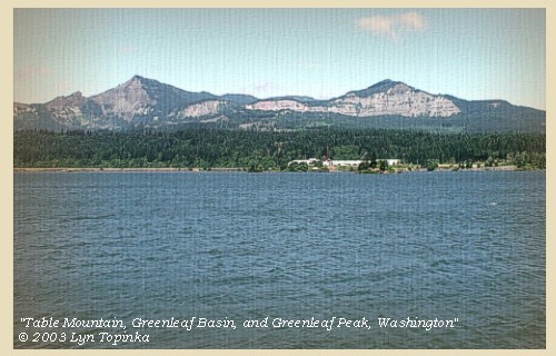
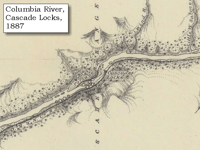
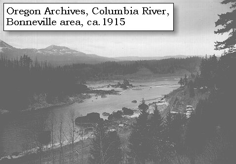
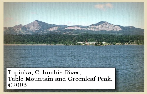
Bonneville Landslide:
The Bonneville Landslide:
The Bonneville Landslide (also known as the Table Mountain Landslide or the Bridge of the Gods Landslide) slid down from the north wall of the Columbia River Gorge sometime between 1400 and 1465 A.D., blocking the Columbia River to a depth of 150-200 feet. Breaching of almost the entire thickness of the landslide dam caused a flood of about 7.7 million cubic feet per second, about six times larger then the largest meteorological flood of the last 150 years. Deposits from the flood form a distinctive marker bed all the way to the Pacific Ocean. The last remnant of the dam was bouldery Cascade Rapids, the namesake of the Cascade Range, now drowned in the pool behind Bonneville Dam. The Bonneville Landslide is part of the Cascade Landslide Complex, an impressive example of mass wasting created by multiple events. The source area includes portions of Table Mountain and the Red Bluffs in Washington. The Cascade Landslide Complex covers 12 to 14 square miles, with individual slide deposits of about 2 to 5 square miles.The Bonneville landslide (a lobe of the complex) has an area of about 5.5 square miles. Debris from the source area reached as far as 3 miles to the southeast and buried the pre-slide Columbia River channel, which was about 1.5 miles north of its present location. The landslide substantially diverted the river channel toward the Oregon shoreline. The second powerhouse of Bonneville Dam abuts against the landslide. If you look north of the dam, you can see the cliffs that were exposed after the mountain gave way. -- O'Connor and Costa, 2004, and Norman and Roloff, 2004


Map, 1814, Lower Falls of the Columbia, click to enlarge Map, 1887, Cascade Locks vicinity, click to enlarge Map, 1911 USGS topo map of Table Mountain vicinity, click to enlarge Map, 1985, Bonneville to Cascade Locks, Oregon, click to enlarge Image, Aerial view, Bonneville Dam, looking east, annotated, click to enlarge Image, ca.1915, Columbia River at Bonneville, click to enlarge Image, ca.1940, Table Mountain, Washington, click to enlarge Image, 2003, Table Mountain, Greenleaf Basin, and Greanleaf Peak, Washington
  1. 1814 Map, Lower Falls of the Columbia, by Lewis and Clark. (Click to enlarge). This map is found in Travels to the source of the Missouri River and across the American continent to the Pacific Ocean : performed by order of the government of the United States, in the years 1804, 1805, and 1806, by Captains Lewis and Clarke. Published from the official report, 1814.
  2. 1887 Map (section of original), Columbia River and the Cascade Locks vicinity. (Click to enlarge). Original Map: The Columbia River from Celilo to the mouth showing locations of the salmon fisheries, 1887. Scale ca. 1:375,000, Relief shown by hachures. U.S. Army Corps of Engineers, Engineer Office, G.P.O. 1888. University of Washington Archives #UW128. -- University of Washington Library Archives Website, 2002
  3. 1911 Map (section of original), from Mount Hood and Vicinity 1:125,000 topographic quadrangle. (Click to enlarge). Original map surveyed in 1907 and 1909-1911, contour interval of 100 feet. -- University of Washington Library Collections Website, 2002
  4. 1985 Map (section of original), Bonneville to Cascade Locks, Oregon. (Click to enlarge). Office of Coast Surveys, Historical Maps and Charts, Columbia River, Bonneville to The Dalles, 1985, Chart#18531, 1:40,000. -- NOAA Office of Coast Survey Website, 2004
  5. Aerial view, Columbia River, Bonneville Dam, and the Bonneville Landslide, annotated. (Click to enlarge). Washington State is on the left with a good view of the Bonneville Landslide jutting into the Columbia River. Oregon is on the right. Bradford Island is crossed by the Bonneville Dam. Hamilton Island is in the foreground. Annotation includes Columbia River, Bonneville Dam, Interstate 84, Bonneville Landslide, Hamilton Island, and Bradford Island. -- U.S. Army Corps of Engineers Website, 2003
  6. ca.1915, Columbia River at Bonneville, approximately 1915. (Click to enlarge). Oregon State Archives, Oregon Water Resources Department #OWR0102. Photograph Date: ca.1915. -- Oregon State Archives Website, 2002
  7. ca.1940, Photograph shows the Bonneville Dam on the Columbia River, looking northerly from the Oregon side, approximately 1940. Table Mountain (left) and Greenleaf Peak (right), on the Washington side, are visible in the distance. (Click to enlarge). Oregon State Archives, Oregon State Highway Division #OHD1329. Photograph Date: ca.1940. -- Oregon State Archives Website, 2002
  8. 2003, Table Mountain, Greenleaf Basin, and Greenleaf Peak, Washington, as seen from across the Columbia River at Cascade Locks, Oregon. (Click to enlarge). Copyright © 2003 Lyn Topinka, private archives, used with permission.


The canoes were drawn on shore and secured, but one of them having got loose, drifted down to the last village, the inhabitants of which brought her back to us; an instance of honesty which we rewarded with a present of two knives. It rained all night.


Along the Journey - April 10, 1806
The Camp - April 10 and April 11, 1806:
Lewis and Clark camped on the Washington side of the Columbia, at a location now above the Bonneville Dam.


Friday, April 11, 1806
The tents, and skins which covered the baggage, were wet. We therefore determined to take the canoes first over the portage [across Bonneville Landslide, passed the rapids and falls of the Cascade Locks area], in hopes that by the afternoon the rain would cease, and we might carry our baggage across without injury. This was immediately begun by almost the whole party, who in the course of the day dragged four of the canoes to the head of the rapids, with great difficulty and labour. ......
"... this portage is two thousand eight hundred yards along a narrow rough and slipery road. ..." [Lewis, April 11, 1806]
"... rained the greater part of last night and continues this morning. all of the party except a fiew to guard the baggage turned out with Capt. Clark to takeing up our canoes with the tow Rope up the big Shoote took one large one and one Small one at once the large one filled at the highest pitch where it is allmost perpinticular but with Some difficulty we got the 2 to the head of the portage about noon. then went back took dinner and took another large canoe and a Small one the other smallest one was taken & carried by land. this large canoe filled twice with water at the worst pitch but with some difficulty & hard fatigue got them Safe up towards evening by the assistance of a number of Indians at the worst pitch &C. and halled the large canoe up by force allthough She was full of water. the most of the mens feet sore towing over the Sharp rocks. our officers made a chief of the nation gave meddle &C. Drewyer and the 2 Fields Sent on a head with their little canoe to a creek on the N. Side to hunt untill our arival. ..." [Ordway, April 11, 1806]
"... by the evening Capt. C. took 4 of our canoes above the rapids tho' with much difficulty and labour. the canoes were much damaged by begin driven against the rocks in dispite of every precaution which could be taken to prevent it. the men complained of being so much fatiegued in the evening that we posposned taking up our 5th canoe untill tomorrow. these rapids are much worse than they were fall when we passed them, at that time there were only three difficult points within seven miles, at present the whole distance is extreemly difficult of ascent, and it would be impracticable to decend except by leting down the empty vessels by a cord and then even the wrisk would be greater than in taking them up by the same means. the water appears to be (considerably) upwards of 20 feet higher than when we decended the river ..." [Lewis, April 11, 1806]
Many Indians from the villages above, passed us in the course of the day, on their return from trading with the natives of the valley, and among others, we recognised an Eloot, who with ten or twelve of his nation were on their way home to the long narrows of the Columbia. These people do not, as we are compelled to do, drag their canoes, up the rapids, but leave them at the head, as they descend, and carrying their good across the portage, hire or borrow others from the people below. When the trade is over they return to the foot of the rapids, where they leave these boats and resume their own at the head of the portage. The labour of carrying the goods across is equally shared by the men and women, and we were struck by the contract between the decent conduct of all the natives from above and the profligacy and ill manners of the Wahclellahs. About three quarters of a mile below our camp is a burial ground, which seems common to the Wahclellahs, Clahclellahs, and Yehhuhs. It consists of eight sepulchres on the north bank of the river.


Along the Journey - April 11, 1806
The Camp - April 10 and April 11, 1806:
Lewis and Clark camped on the Washington side of the Columbia, at a location now above the Bonneville Dam.


Home Previous Continue


If you have questions or comments please contact: GS-CVO-WEB@usgs.gov
June/July 2004, Lyn Topinka
The Volcanoes of Lewis and Clark Home Page | CVO Home Page