|
April 6 - 8, 1806 Columbia River Gorge - Cottonwood Beach to Shepperd's Dell |
|
Home
The Volcanoes of Lewis and Clark Map of the Journey Volcanoes, Basalt Plateaus, Major Rivers, etc. The Volcanoes Mount Adams, Mount Hood, Mount Jefferson, Mount Rainier, and Mount St. Helens CALENDAR of the Journey October 1805 to June 1806 Along the Journey Pacific Northwest Maps - Columbia River, Volcanoes, Flood Basalts, Missoula Floods, Geology, etc. The Corps of Discovery The Journey of Lewis and Clark About the Reference Materials The Journals, Biddle/Allen, DeVoto, Gass, Moulton, Topo Maps, and others USGS Lewis and Clark Links Links to USGS Websites highlighting the Lewis and Clark Journey Resources Publications Referenced and Websites Visited |
PREVIOUS
April 4-5 Back on the Columbia, The Willamette Valley |
April 6-8
Columbia River Gorge, Cottonwood Beach Camp to Shepperd's Dell Cottonwood Beach, Steigerwald Lake NWR, Mount Hood, Columbia River Gorge National Scenic Area, Crown Point, Shepperd's Dell State Park, Rooster Rock and Rooster Rock State Park |
CONTINUE
April 9 Columbia River Gorge, Shepperd's Dell to Bonneville |
On October 7, 1805, Lewis and Clark and the
"Corps of Discovery" began their journey
down the Clearwater River and into the volcanics
of the Pacific Northwest. The Corps travelled from the
Clearwater to the Snake and down the
"Great Columbia", finally reaching the
Pacific Ocean on November 15, 1805.
Along the journey they encountered the
lava flows of the Columbia Plateau,
river channels carved by the great "Missoula Floods",
and the awesome beauty of five Cascade Range volcanoes.

[Click map for brief summary about the area] |
|
Heading for Home - April 1806
Columbia River Gorge - Cottonwood Beach to Shepperd's Dell |
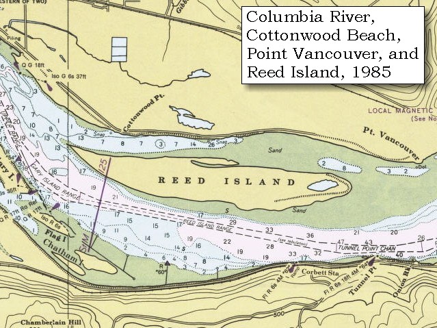
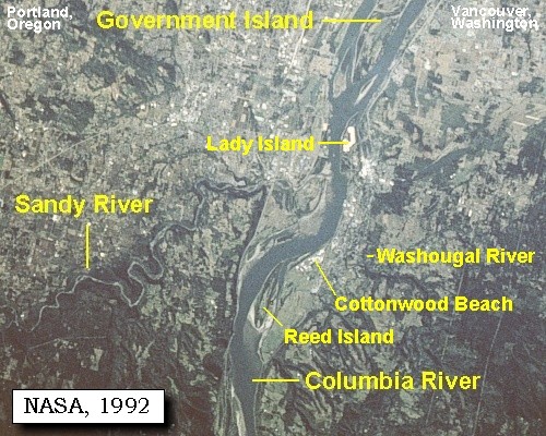
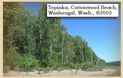
| Between March 31 and April 5, 1806 Lewis and Clark camped near present day Cottonwood Beach, just upstream of Washougal, Washington. |
| Sunday, April 6, 1806 |
| Having made our preparations of dried meat, we set out [from Cottonwood Beach, just upstream of Washougal, Washington] ...... |
|
|
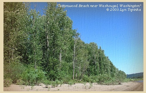
Cottonwood Beach: Between March 31 and April 5, 1806 the Corps of Discovery camped near present day Cottonwood Beach in Washougal. From this campsite, William Clark also led a group of men back down the Columbia to discover the Willamette River, which they had missed on both their outward and return voyages. Presently, the cities of Washougal and Camas, Port of Camas/Washougal, and the Clark County Parks Department, are collaborating on creating a regional park at this location and it has been named Capt. William Clark Park at Cottonwood Beach. -- City of Washougal, Washington, Website, 2002 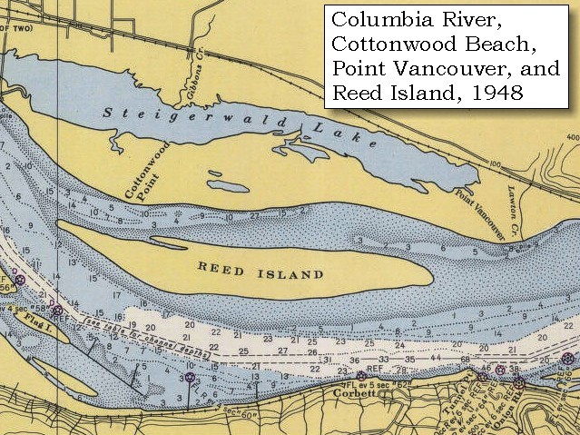
|
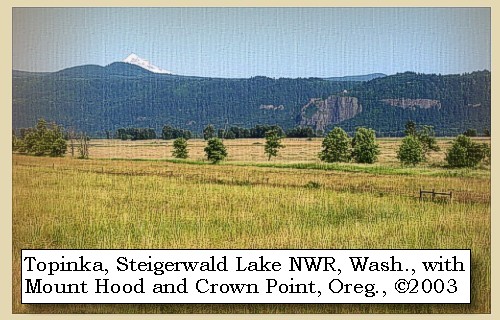
| by nine o'clock, and continued along the north side of the river [Washington State] for a few miles [today this area is part of the Steigerwald Lake National Wildlife Refuge], and then crossed to the river [Oregon] to look for the hunters, who had been sent forward the day before yesterday. |
| "... passed a beautiful prairie on the north side, which we could not see for the fog as we went down; ..." [Gass, April 6, 1806] |
| Lewis and Clark first passed this area on November 3, 1805, a day which "The Fog So thick this morning that we could not See a man 50 Steps off". Mount Hood, Oregon, can be seen along this stretch of the river. |
|
|
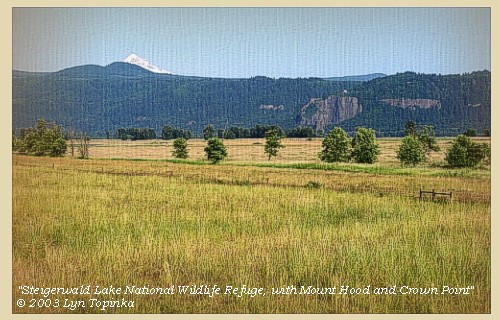
Steigerwald Lake National Wildlife Refuge: Steigerwald Lake National Wildlife Refuge consists of more than 950 acres of historic lakebed and river bottomland habitat with wetlands, riparian areas, grasslands, and hardwood forest. The refuge, which provides habitat for wintering waterfowl and year-round habitat fro a variety of wildlife species, can be viewed from Washington State Highway 14. -- U.S. Fish and Wildlife Service Website, 2003
|
| Lewis and Clark are entering the scenic Columbia River Gorge. |
|
|
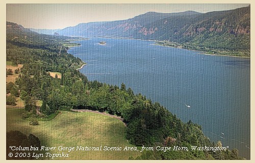
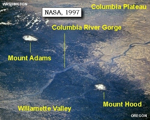
Columbia River Gorge National Scenic Area: Lewis and Clark have entered what is today the "Columbia River Gorge National Scenic Area". The Columbia River Gorge is a spectacular river canyon cutting the only sea-level route through the Cascade Mountain Range. The Gorge is 80 miles long and up to 4,000 feet deep, with the north canyon walls in Washington State and the south canyon walls in the State of Oregon. The "Gorge" is located approximately 20 miles east of Portland, Oregon, with Visitor Centers being located at Skamania Lodge, Multnomah Falls, the Gorge Discover Center in The Dalles, and at Bonneville Dam. -- U.S. Forest Service Website, 2002, and Lewis and Clark Bicentennial "lewisandclar200.gov" Website, 2002 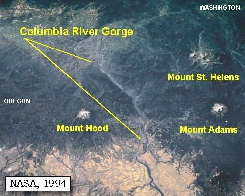
|
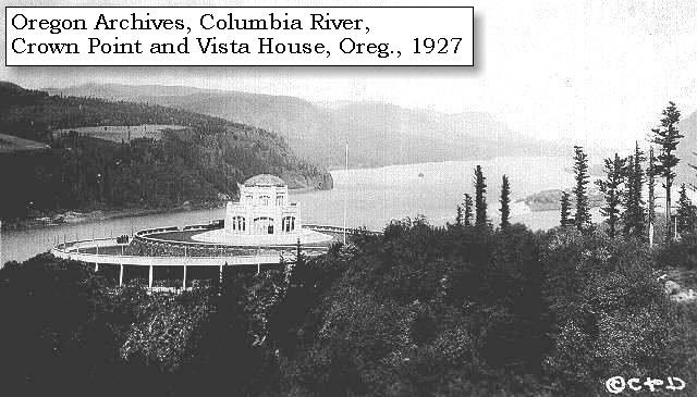
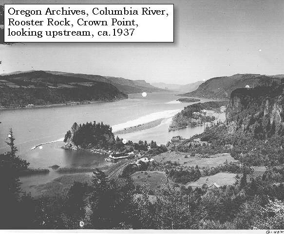
| As Lewis and Clark entered the Columbia River Gorge, the massive basalt cliff of Crown Point was on their right. |
|
|
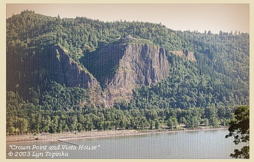
Crown Point: Crown Point and Vista House are located 11 miles east of Troutdale, Oregon. The Vista House was built in 1916 at the same time as Highway 30 (what is now the Historic Columbia River Gorge Highway, and the only way to reach Crown Point). The building was designed to be a place of refreshment and enjoyment of the Columbia Gorge. The octagonal building with its copper dome now houses a museum, gift shop and interpretive display of historic and geologic points of interest in the Gorge. -- Beeson and Tolan, 1987, and Oregon State Parks and Recreation Website, 2002 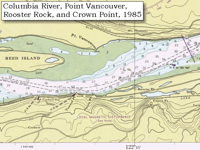
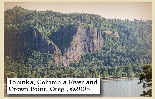
Geology of Crown Point: Crown Point is the massive valley-fill of a Priest Rapids flow of Columbia River basalt, about 14 million years old, which filled the canyon. The lower part of the cliff is made up of a thick section of volcanic sediments which partly filled the canyon before it was covered by the lava flow. The single Priest Rapids flow consists of 508 feet of hackly jointed basalt which in turn overlies more than 198 feet of bedded Priest Rapids hyaloclastite. Below and to the west of Crown Point is Rooster Rock slide block and the Crown Point landslide. The slide plane of the Crown Point landslide is probably the unconformable contact between the younger Priest Rapids intracanyon flow and earlier Columbia River basalt flows or the older volcanic rocks. -- Allen, 1985, Time Travel in Oregon, and Beeson and Tolan, 1987 |
| We found them at the upper end of the bottom with some Indians, for we are never freed from the visits of the natives. They had killed three elk, and wounded two others so badly, that it was still possible to get them. We therefore landed, and having prepared scaffolds and secured the five elk, we encamped for the night [Shepperd's Dell vicinity] ...... |
| "... proceeded on about 9 miles and came to our hunters' camp. They had killed 5 elk, so we halted, sent out for the meat and began to dry it. We are now at the head of the Columbia valley; which is a fine valley about 70 miles long, abounding with roots of different kinds, which the natives use for food, especially the Wapto roots which they gather out of the ponds. The timber is mostly of the fir kind, with some cherry, dogwood, soft maple and ash; and a variety of shrubs which bear fruit of a fine flavour, that the natives make use of for food. ..." [Gass, April 6, 1806] |
| "... we Camped here for the night in a Small willow bottom near high river hills on South Side ..." [Ordway, April 6, 1806] |
|
|
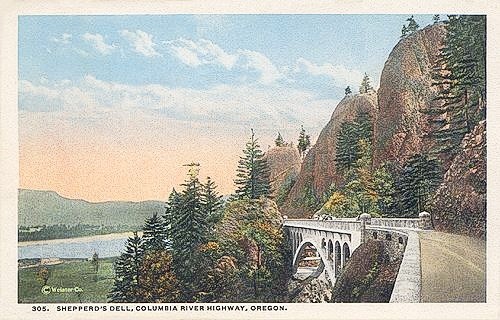
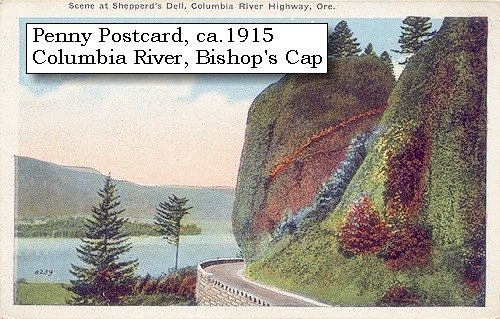
Shepperd's Dell State Park: In 1915, a local dairy farmer named George Sheppherd gave all that he had (this tract of land) to the City of Portland as a memorial to his wife. Today, thousands of visitors along the Historic Columbia River Highway visit this beautiful spot, with its roaring waterfall cascading down steep cliffs into Youngs Creek and out to the Columbia River far below. The upper fall is around 42' tall. The lower tier is around 50' tall. One of the most beautiful and historic highway bridges crosses the canyon here, but you can't see or appreciated it unless you leave your car and take the short trail to the falls. Shepperd's Dell State Park is located along Historic Columbia River Highway, 14 miles east of Troutdale, Oregon. -- Oregon State Parks and Recreation Website, 2002 

|
| "... from the appearance of a rock [Rooster Rock] near which we were encamped on the 3rd of November last [in error, see below] I could judge better of the rise of the water than I could at any point below. I think the flood of this spring has been about 12 feet higher than it was at that time; the river is here about 1 1/2 miles wide; it's general width from the beacon rock which may be esteemed the head of tide water, to the marshey islands is from one to 2 miles tho' in many places it is still wider. it is only in the fall of the year when the river is low that the tides are persceptable has high as the beacon rock. [Beacon Rock, see April 9, 1806 entry] ..." [Lewis, April 6, 1806] |
| Lewis and Clark's camp of November 3, 1805 was near Government Island, and not near Rooster Rock. Their camp of November 2, 1805 was near Rooster Rock. |
|
|
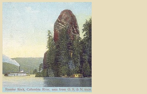
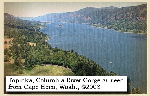
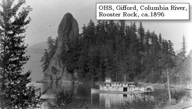
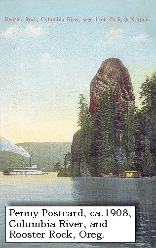
Rooster Rock and Rooster Rock State Park: Rooster Rock is a landslide portion of a lava flow which filled an early ancestral canyon of the Columbia River thousands of years ago, at the location of today's Crown Point. The scar is still visible on the cliff above Rooster Rock. Rooster Rock State Park is located 22 miles east of Portland, Oregon, along Interstate 84. Enjoy three miles of sandy beaches and a swimming area. -- Norman and Roloff, 2004, Washingon State DNR Open-File Report 2004-7, and Oregon Parks and Recreation Website, 2002.

|
|
|
|
The Camp - April 6 through April 8, 1806:
Lewis and Clark camped for three nights in the area of today's Shepperd's Dell State Park, Oregon. |
Monday, April 7, 1806
| The weather having been fair and pleasant, had dried a sufficient quantity of meat to serve us far as the Chopunnish, with occasional suppies, if we can procure them, of dogs, roots, and horses. In the course of the day several parties of Shahalas, from a village eight miles above us, came to visit us, and behaved themselves very properly, except that we were obliged to turn one of them from the camp for stealing a piece of lead. Every thing was now ready for our departure. |
|
|
|
The Camp - April 6 through April 8, 1806:
Lewis and Clark camped for three nights in the area of today's Shepperd's Dell State Park, Oregon. |
Tuesday, April 8, 1806
| In the morning The wind blew with great violence, and we were obliged to unload our boats, which were soon after filled with water. The same cause prevented our setting out to-day; we therefore despatched several hunters round the neighbourhood, but in the evening they came back with nothing but a duck. ...... |
|
|
|
The Camp - April 6 through April 8, 1806:
Lewis and Clark camped for three nights in the area of today's Shepperd's Dell State Park, Oregon. |
| Home | Previous | Continue |
If you have questions or comments please contact: GS-CVO-WEB@usgs.gov
June/July 2004, Lyn Topinka
The Volcanoes of Lewis and Clark Home Page | CVO Home Page