The Volcanoes of
Lewis and Clark
April 13, 1806
Columbia River Gorge - Cascade Locks to Dog Mountain
 
Home
The Volcanoes of Lewis and Clark

Map of the Journey
Volcanoes, Basalt Plateaus, Major Rivers, etc.

The Volcanoes
Mount Adams, Mount Hood, Mount Jefferson, Mount Rainier, and Mount St. Helens

CALENDAR of the Journey
October 1805 to June 1806

Along the Journey
Pacific Northwest Maps - Columbia River, Volcanoes, Flood Basalts, Missoula Floods, Geology, etc.

The Corps of Discovery
The Journey of Lewis and Clark

About the Reference Materials
The Journals, Biddle/Allen, DeVoto, Gass, Moulton, Topo Maps, and others

USGS Lewis and Clark Links
Links to USGS Websites highlighting the Lewis and Clark Journey

Resources
Publications Referenced and Websites Visited


PREVIOUS

April 12
Columbia River Gorge, "Lower Falls of the Columbia", Cascade Locks
April 13

Columbia River Gorge,
Cascade Locks to Dog Mountain

"Lower Falls of the Columbia" and Cascade Locks, Wind River, Dog Mountain Landslide
CONTINUE

April 14
Columbia River Gorge, Dog Mountain to Major Creek
 

On October 7, 1805, Lewis and Clark and the "Corps of Discovery" began their journey down the Clearwater River and into the volcanics of the Pacific Northwest. The Corps travelled from the Clearwater to the Snake and down the "Great Columbia", finally reaching the Pacific Ocean on November 15, 1805. Along the journey they encountered the lava flows of the Columbia Plateau, river channels carved by the great "Missoula Floods", and the awesome beauty of five Cascade Range volcanoes.

Map, Lewis and Clark in the Pacific Northwest, click for brief
                         summary
[Click map for brief summary about the area]


Heading for Home - April 1806
Columbia River Gorge - Cascade Locks to Dog Mountain
 

Lewis and Clark's camp of April 12, 1806, was on the Washington side of the Columbia River, above the Cascade Locks.

Sunday, April 13, 1806
The loss of our periogue yesterday obliges us to distribute our leading between the two canoes, and the two remaining periogues. This being done, we proceeded along the north side of the river [Washington State], but soon finding that the increased loading rendered our vessels difficult to manage, if not dangerous in case of high wind, the two periogues only continued on their route, while captain Lewis with the canoes crossed over to the Yehhuh village [in the area of Cascade Locks], with a view of purchasing one or two more canoes. ......


Along the Journey - April 13, 1806
Cascade Locks looking downstream, 2003

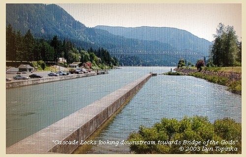
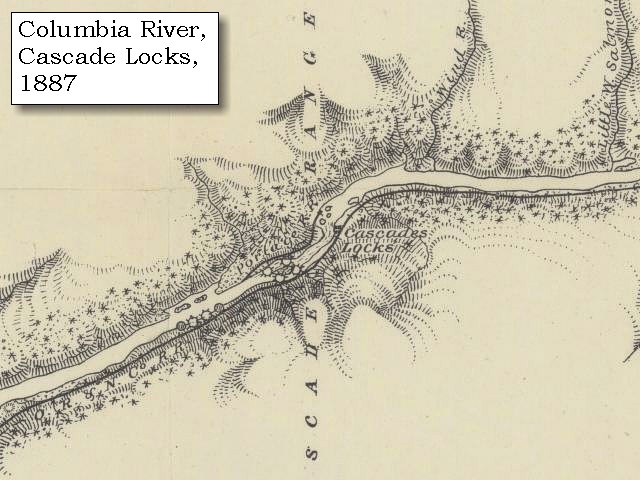
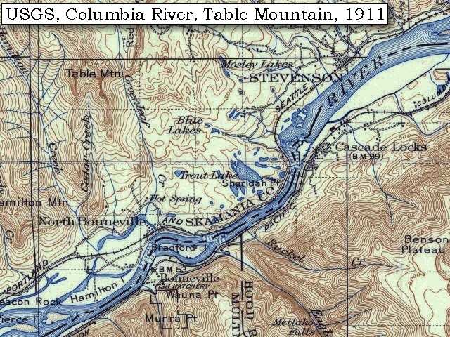
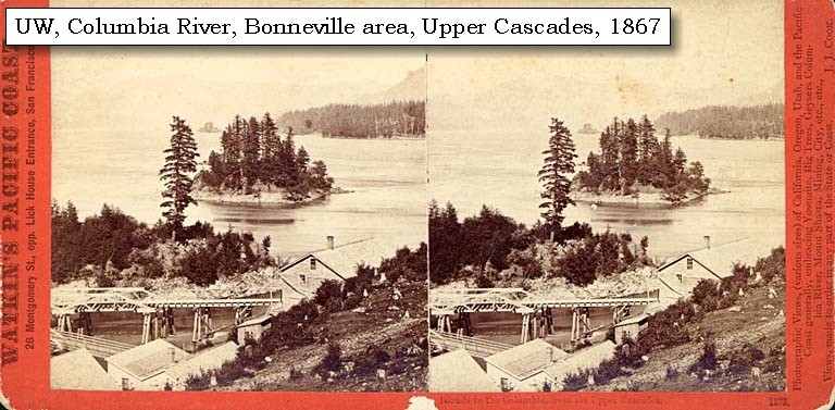
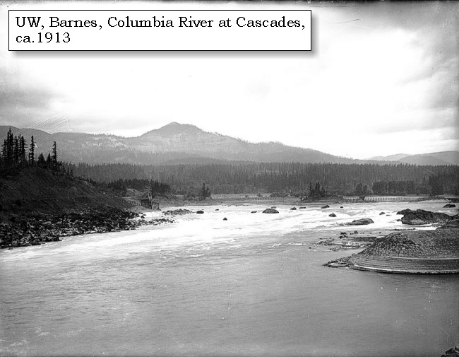
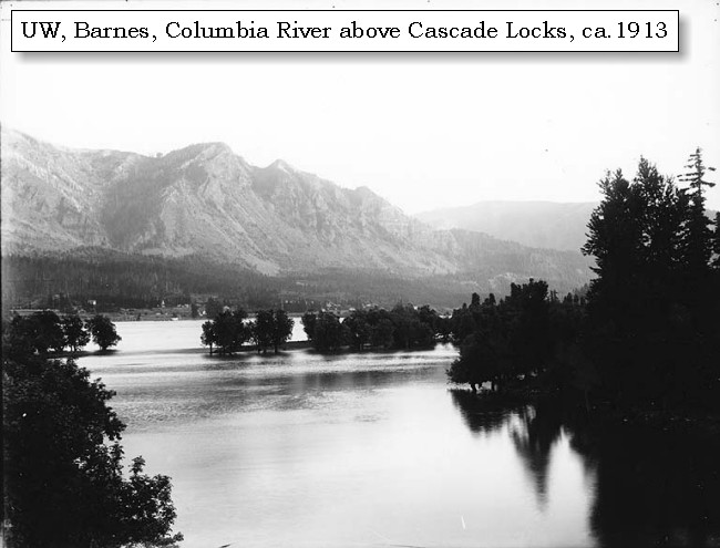
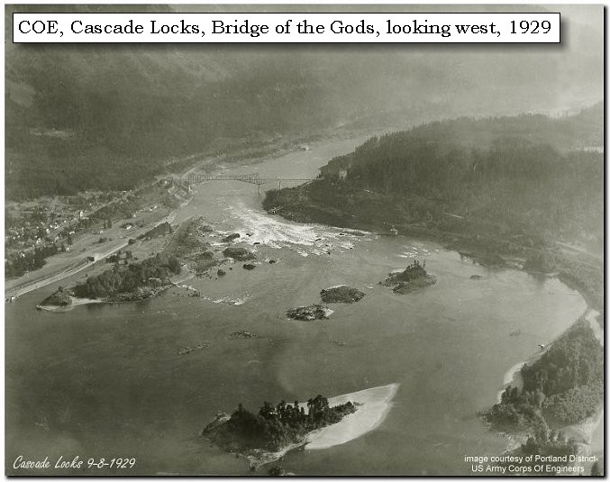
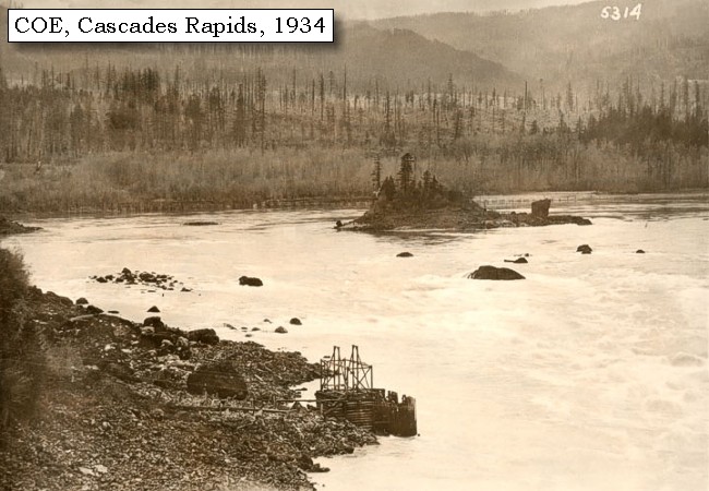
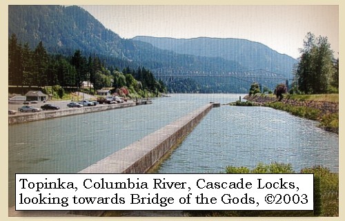
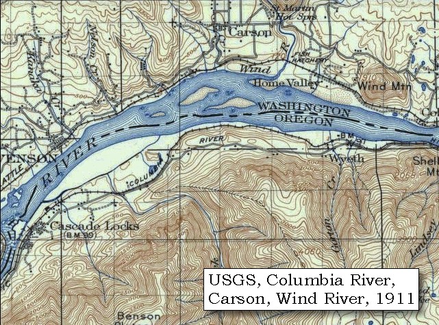
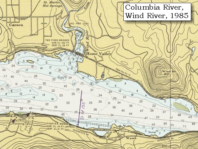
"Lower Falls of the Columbia" and Cascade Locks:
Lewis and Clark called the area around today's Cascades Locks "the Lower Falls of the Columbia" -- the Celilo Falls area was known as the "Great Falls of the Columbia". Throughout time, the area became known as the "Cascades", and in 1825, John Work of the Hudson's Bay Company was the first to record the place name, "Cascades," to describe these falls in the Columbia. Four and a half miles long, the Cascades of the Columbia were separated into two sections. The first made a bend around a rocky point on the Oregon shore, then went into a 2,000-foot-long pitch in the river and a 21-foot drop. This was called the Upper Cascade. The rest of the contracted waterway, the Lower Cascade, was a long three-and-a-half-mile pitch in the river. The total fall of the river from the head of Upper Cascade to the bottom of Lower Cascade was 45 feet at high water and 36 feet at low water. Lewis and Clark first portaged around the "Lower Falls of the Columbia" in 1805, on their journey to the Pacific. Forty years later the pioneers traveling the water route on the Oregon Trail made the same portage. In 1850 a road was built on the north side of the Columbia to portage around the rapids, and a small settlement developed to help travelers around the rapids, first by foot and then by mule-drawn rail cars. In 1864, the first steam engine in the Northwest carried passengers and freight past the rapids. In 1896 a 3,000-foot-long navigational canal with locks was completed and the modern-day town of Cascade Locks developed. The Cascades and the early locks were flooded by backwater from Bonneville Dam in 1937. -- "www.cascadelocks.net" Website, 2004, and Washington State Historical Society Website, 2004, "Lasting Legacy".


Map, 1814, Lower Falls of the Columbia, click to enlarge Map, 1854, Columbia River, Fort Vancouver area, click to enlarge Map, 1887, Cascade Locks vicinity, click to enlarge Map, 1911 USGS topo map of Cascade Locks to Bonneville area, click to enlarge Map, 1985, Bonneville to Cascade Locks, Oregon, click to enlarge Stereo Image, 1867, near the Upper Cascaldes, click to enlarge Image, ca.1913, Columbia River at the Cascades, click to enlarge Image, ca.1913, Columbia River, Oregon banks, at Cascade Locks, click to enlarge Image, 1927, Cascade Locks, click to enlarge Image, 1929, Cascade Locks, click to enlarge Image, 1934, Cascades Rapids, click to enlarge Image, 2003, Cascade Locks looking downstream
  1. 1814 Map, Lower Falls of the Columbia, by Lewis and Clark. (Click to enlarge). This map is found in Travels to the source of the Missouri River and across the American continent to the Pacific Ocean : performed by order of the government of the United States, in the years 1804, 1805, and 1806, by Captains Lewis and Clarke. Published from the official report, 1814. -- Washington State University Library Archives Website, 2002
  2. 1853-54 Map, Columbia River, including the Fort Vancouver area (section of original). (Click to enlarge). Includes Longview, Washington (Monticello), Coweeman River (Minter R.), Kalama River (Ca-la-ma R.), Lewis River (Cath-la-pootle R.), Willamette River, Fort Vancouver, Cape Horn, and "The Cascades". Vancouver Lake is depicted but not labeled. Original Map: "Rocky Mountains to Puget Sound : from explorations and surveys / made under the direction of the Hon. Jefferson Davis, Secretary of War by Isaac I. Stevens Governor of Washington Territory, 1853-4." Inset: (Supplementary sketch) Reconnaissance of the railroad route from Wallawalla to Seattle via Yak-e-mah River & Snoqualmie Pass. By A. W. Tinkham in January 1854. Drawn by J. R. P. Mechlin. 20 x 28 cm. Topographer, John Lambert, Published in Washington D.C., 1859, 1:1,200,000, Notes: From the U.S. War Department, Explorations and Surveys for a Railroad Route from the Mississippi River to the Pacific Ocean, Topographical Maps, to Illustrate the Various Reports, U.S. Library of Congress American Memories Reference "LC Railroad Maps #156". -- U.S. Library of Congress, American Memories Website, 2004
  3. 1887 Map (section of original), Columbia River and the Cascade Locks vicinity. (Click to enlarge). Original Map: The Columbia River from Celilo to the mouth showing locations of the salmon fisheries, 1887. Scale ca. 1:375,000, Relief shown by hachures. U.S. Army Corps of Engineers, Engineer Office, G.P.O. 1888. University of Washington Archives #UW128. -- University of Washington Library Archives Website, 2002
  4. 1911 Map (section of original), from Mount Hood and Vicinity 1:125,000 topographic quadrangle. (Click to enlarge). Original map surveyed in 1907 and 1909-1911, contour interval of 100 feet. -- University of Washington Library Collections Website, 2002
  5. 1985 Map (section of original), Bonneville to Cascade Locks, Oregon. (Click to enlarge). Office of Coast Surveys, Historical Maps and Charts, Columbia River, Bonneville to The Dalles, 1985, Chart#18531, 1:40,000. -- NOAA Office of Coast Survey Website, 2004
  6. 1867, Stereo view, near the Upper Cascades. (Click to enlarge). Caption on image: Islands in the Columbia from the Upper Cascades. Photographer: Carleton E. Watkins. Photo Date: 1867. University of Washington Sterocard Collection #STE043, Stereocard Collection No. 58. -- University of Washington Libraries Collection Website, 2003
  7. ca.1913, Columbia River at Cascade Locks. (Click to enlarge). Greenleaf Peak is visible in the distance. Photo by Albert Henry Barnes, ca.1913. University of Washington A.H. Barnes Collection #BAR020. -- University of Washington Library Archives, 2003
  8. ca.1913, Columbia River and Oregon banks, at Cascade Locks. (Click to enlarge). Photo by Albert Henry Barnes, ca.1913. University of Washington A.H. Barnes Collection #BAR038. -- University of Washington Library Archives, 2003
  9. 1927 aerial view, Cascade Locks. (Click to enlarge). A Burner from Wind River Mill entering Cascade Locks, Oregon. U.S. Army Corps of Engineers Archives #700-41. Photograph Date: August 1927. -- U.S. Army Corps of Engineers Website, 2002
  10. 1929 aerial view, Cascade Locks. (Click to enlarge). U.S. Army Corps of Engineers Archives. Photograph Date: September 8, 1929. -- U.S. Army Corps of Engineers Website, 2002
  11. 1934, Cascades Rapids. (Click to enlarge). From Bridge of the Gods showing the Cascade Rapids looking upstream. U.S. Army Corps of Engineers Photograph #700-40. Photograph Date: March 29, 1934. -- U.S. Army Corps of Engineers Website, 2002
  12. 2003, Cascade Locks looking downstream towards Bridge of the Gods. (Click to enlarge). Copyright © 2003 Lyn Topinka, private archives, used with permission.


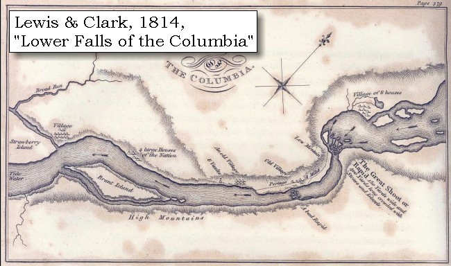
He [Captain Lewis] proceeded along the south side of the river [Oregon], and joined us in the evening. We had gone along the north shore as high as Cruzatte's river [Wind River], to which place we had sent some hunters the day before yesterday, and where we were detained by the high winds.


Along the Journey - April 13, 1806
Wind River looking upstream, 2003

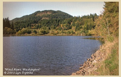
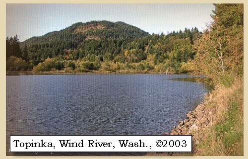
Wind River:
Wind River basin, located in southwestern Washington, originates in McClellan Meadows in the western Cascades and enters Bonneville Reservoir at River Mile (RM) 154.5 near Carson, Washington. Wind River drains approximately 225 square miles over a distance of 31 miles. Principle tributaries to Wind River include Little Wind River, Bear, Panther, Trout, Trapper, Dry, Nineteenmile, Falls and Paradise creeks. The Wind River watershed has been shaped through 25 million years of volcanic activity and glacial action. Most of the watershed was formed 12 and 25 million years ago with some younger flows out of Indian Heaven and Trout Creek Hill being dated between 350,000 to three million. The majority of the watershed is in the older volcaniclastic material. The basin is oriented northwest to southeast with elevations ranging from 80 to 3,900 feet. Topography varies within the watershed; it is steep in the northwest and lower southeast, gentle in the northeast - McClellan Meadows area, and it is benchy in Trout Creek Flats and middle portions of the Wind River Valley. The mainstem of the Wind River drops 3,820 feet for an average gradient of 2.3 percent. Shepherd Falls, located at RM 2.0, is a series of four falls ranging from 8 to 12 feet that were a barrier to all anadromous salmonids except steelhead until the construction of a fish ladder in 1956. Originally Lewis and Clark called this river the "New Timber River". The name was later changed to "Crusatts River," after a member of the corps, Pierre Cruzatte, when Captain Clark realized that Cruzatte was the only member of the corps who had not been honored with a place name on the westbound journey. He changed the name on the route map and course distance log, correcting the oversight. The present descriptive name was given by Isaac Stevens in 1853. -- Columbia Basin Fish and Wildlife Authority Website, 2002, and Washington State Historical Society Website, 2002


Map, 1999, Mount Adams and Vicinity, click to enlarge Map, 1814, Lewis and Clark on the Columbia, click to enlarge Map, 1887, Cascade Locks vicinity, click to enlarge Map, 1911 USGS topo map of Wind River area, click to enlarge Map, 1985, Wind River and Wind Mountain, click to enlarge Image, 2003, Wind River, Washington
  1. 1999, Map, Mount Adams and Vicinity, showing drainages into the Columbia River. (Click to enlarge). Includes the Wind River, Little White Salmon River, White Salmon River, and Klickitat River in Washington State, and the Hood River in Oregon. Map modified from Vallance, 1999, USGS Bulletin 2161.
  2. 1814 Map, Lewis and Clark's map of the Columbia River (section of original). (Click to enlarge.) Shows the Wind River ("Crusatts R."). Map includes three of the five volcanoes Lewis and Clark saw and commented on. While the journals mention the expedition seeing Mount Adams, it does not appear on their map. Mount Jefferson is to the south (bottom) and off the map. From the "Nicholas Biddle/Paul Allen" 1814 publication. Original Map: "A Map of Lewis and Clark's Track, Across the Western Portion of North America, From the Mississippi to the Pacific Ocean". From: History of the expedition under the command of Captains Lewis and Clark : to the sources of the Missouri, thence across the Rocky Mountains and down the river Columbia to the Pacific Ocean : performed during the years 1804-5-6 : by order of the government of the United States / prepared for the press by Paul Allen. Philadelphia : Bradford and Insskeep, 1814. Harold B. Lee Library, Brigham Young University #upbover maps37. -- Brigham Young University, Harold B. Lee Library Website, 2004.
  3. 1887 Map (section of original), Columbia River and the Cascade Locks vicinity, including the Wind River. (Click to enlarge). Original Map: The Columbia River from Celilo to the mouth showing locations of the salmon fisheries, 1887. Scale ca. 1:375,000, Relief shown by hachures. U.S. Army Corps of Engineers, Engineer Office, G.P.O. 1888. University of Washington Archives #UW128. -- University of Washington Library Archives Website, 2002
  4. 1911 Map (section of original), from Mount Hood and Vicinity 1:125,000 topographic quadrangle. (Click to enlarge). Original map surveyed in 1907 and 1909-1911, contour interval of 100 feet. -- University of Washington Library Collections Website, 2002
  5. 1985 Map (section of original), Wind River and Wind Mountain, Washington. (Click to enlarge). Office of Coast Surveys, Historical Maps and Charts, Columbia River, Bonneville to The Dalles, 1985, Chart#18531, 1:40,000. -- NOAA Office of Coast Survey Website, 2004
  6. 2003, Wind River looking upstream from near mouth. (Click to enlarge). Copyright © 2003 Lyn Topinka, private archives, used with permission.


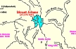
The hunters however did not join us, and we therefore, as soon as the wind had abated, proceeded on for six miles, where we halted for captain Lewis, and in the meantime went out to hunt. [vicinity of Dog Mountain] ......


Along the Journey - April 14, 1806
Dog Mountain, 2002

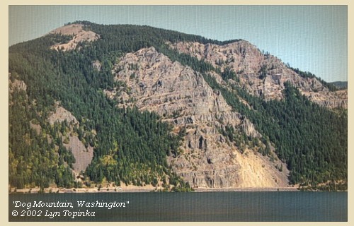
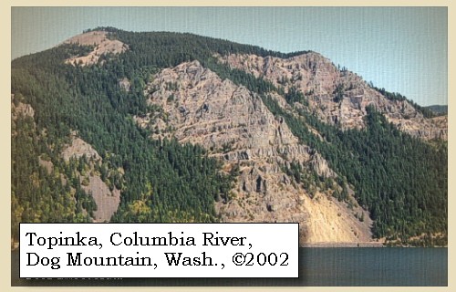
Dog Mountain Landslide:
Local landslides, some taking place as recently as 200 years ago, have occurred in several areas along the Columbia River. The large Bonneville landslide, between the cities of North Bonneville and Stevenson, exposed the Red Bluffs [See Bonneville Landslide, October 31, 1805 entry]. The landslide, which consists chiefly of the Eagle Creek Formation and Yakima Basalt, blocked the Columbia River for a short period. Another landslide between Wind Mountain and Dog Mountain consists chiefly of material from the Ohanapecosh Formation. This landslide is still active. It moves 40 to 50 feet a year at the upper end of the slide and 5 to 10 feet a year at the toe. -- U.S. Forest Service Website, 2002, Gifford Pinchot National Forest


Map, 1911 USGS topo map of Wind Mountain and Dog Mountain area, click to enlarge Image, 2002, Dog Mountain
  1. 1911 Map (section of original), from Mount Hood and Vicinity 1:125,000 topographic quadrangle. (Click to enlarge). Original map surveyed in 1907 and 1909-1911, contour interval of 100 feet. -- University of Washington Library Collections Website, 2002
  2. 2002, Dog Mountain, Washington, as seen from Starvation Creek State Park, Oregon. (Click to enlarge). Copyright © 2002 Lyn Topinka, private archives, used with permission.


Along the Journey - April 13, 1806
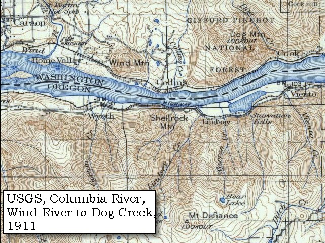
The Camp - April 13, 1806:
Lewis and Clark camped on the Washington side of the Columbia, near Dog Mountain, between Collins Creek and Dog Creek.


Home Previous Continue


If you have questions or comments please contact: GS-CVO-WEB@usgs.gov
June/July 2004, Lyn Topinka
The Volcanoes of Lewis and Clark Home Page | CVO Home Page