The Volcanoes of
Lewis and Clark
April 12, 1806
Columbia River Gorge - "Lower Falls of the Columbia" - Cascade Locks
 
Home
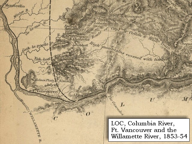
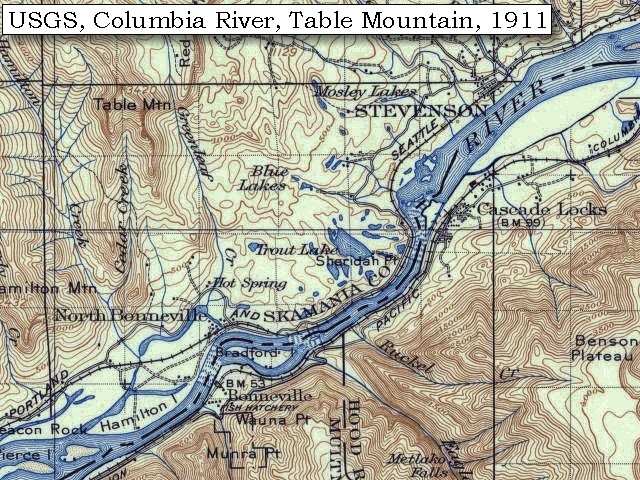
The Volcanoes of Lewis and Clark

Map of the Journey
Volcanoes, Basalt Plateaus, Major Rivers, etc.

The Volcanoes
Mount Adams, Mount Hood, Mount Jefferson, Mount Rainier, and Mount St. Helens

CALENDAR of the Journey
October 1805 to June 1806

Along the Journey
Pacific Northwest Maps - Columbia River, Volcanoes, Flood Basalts, Missoula Floods, Geology, etc.

The Corps of Discovery
The Journey of Lewis and Clark

About the Reference Materials
The Journals, Biddle/Allen, DeVoto, Gass, Moulton, Topo Maps, and others

USGS Lewis and Clark Links
Links to USGS Websites highlighting the Lewis and Clark Journey

Resources
Publications Referenced and Websites Visited


PREVIOUS

April 10-11
Columbia River Gorge, Bonneville Vicinity
April 12

Columbia River Gorge,
"Lower Falls of the Columbia" - Cascade Locks

Bonneville Dam, "Lower Falls of the Columbia" and the Cascade Locks, and the Bridge of the Gods
CONTINUE

April 13
Columbia River Gorge, Cascade Locks to Dog Mountain
 

On October 7, 1805, Lewis and Clark and the "Corps of Discovery" began their journey down the Clearwater River and into the volcanics of the Pacific Northwest. The Corps travelled from the Clearwater to the Snake and down the "Great Columbia", finally reaching the Pacific Ocean on November 15, 1805. Along the journey they encountered the lava flows of the Columbia Plateau, river channels carved by the great "Missoula Floods", and the awesome beauty of five Cascade Range volcanoes.

Map, Lewis and Clark in the Pacific Northwest, click for brief
                         summary
[Click map for brief summary about the area]


Heading for Home - April 1806
Columbia River Gorge - Cascade Locks Vicinity
 

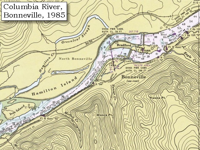
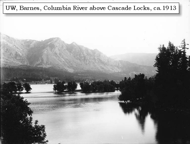
Lewis and Clark's camp of April 10 and April 11, 1806, was on the Washington side of the Columbia River, at a location now above the Bonneville Dam.

Saturday, April 12, 1806
The rain continued all night and this morning. Captain Lewis now took with him all the men fit for duty, and began to drag the remaining periogue over the rapids. This has become much more difficult than when we passed in the autumn; at that time there were in the whole distance of seven miles only three difficult points; but the water is now very considerably higher, and during all that distance the ascent is exceedingly laborious and dangerous, nor would it be practicable to descend, except by letting down the empty boats by means of ropes. The route over this part, from the head to the foot of the portage, is about three miles: the canoes which had been already dragged up were very much injured, by being driven against the rocks, which no precautions could prevent.

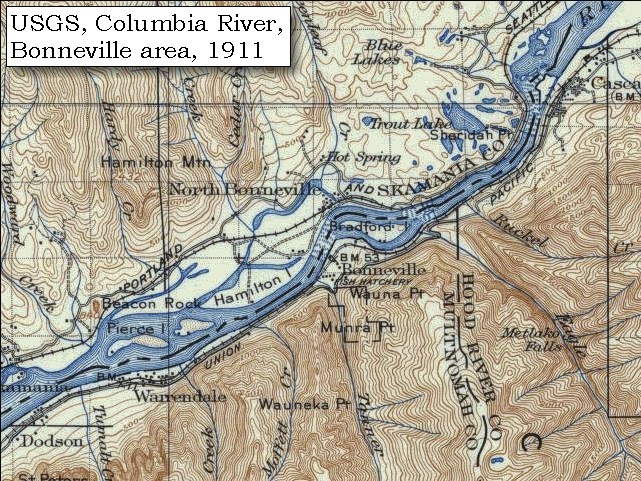
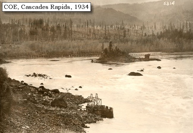
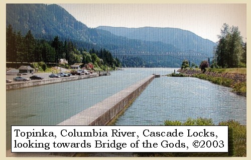
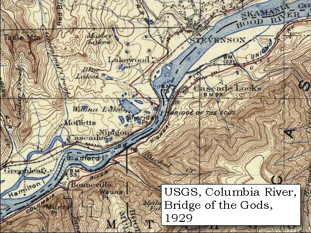
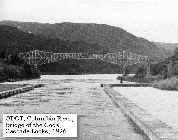
This area was known as the "Lower Falls of the Columbia" and extended from the Bonneville Dam area to north of Cascade Locks, Oregon. In 1896 the Federal Government built a series of locks around the rapids and in 1926 the Bridge of the Gods was built spanning the area.


Along the Journey - April 12, 1806
Bonneville Dam

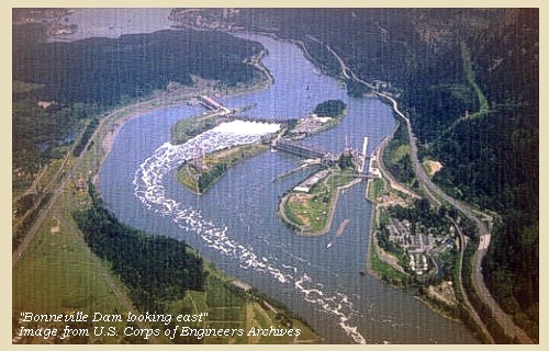
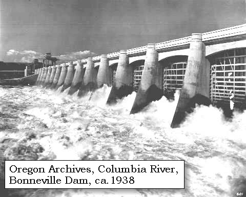
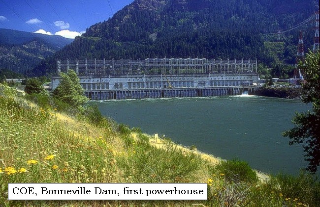
Bonneville Dam:
Bonneville Lock and Dam and Lake Bonneville are in the Columbia River Gorge, one of the most scenic areas in the Pacific Northwest. The walls of the gorge rise 2,000 feet above Lake Bonneville in many places and can be seen from any of the 10 recreation areas around the reservoir. Bonneville Dam spans the Columbia River from Oregon to Washington, a distance of 1,100 feet. Bradford Island, an old Indian burial ground separating the river's two channels, is at the center of the mammoth barrier. Bonneville Dam was begun in 1933 and completed in 1938, and was the first of the major power dams on the Columbia. The dam is a 1,230-foot-long gravity-type, concrete spillway dam across the center channel of the Columbia River and measures 180 feet wide at its base. It has two 350-ton gantry cranes which operate from a service roadway 99 feet above the water, to regulate the 18 movable-crest steel gates. The project required 750,000 cubic of concrete. It cost $88.4 million to build the spillway dam on one side of Bradford Island, a powerhouse, and navigation locks on the other side of the island. The Bonneville Power Administration added a second powerhouse in the 1980s and dug a channel through Bradford Island. Bonneville Dam was named for Captain Benjamin de Bonneville. -- U.S. Army Corps of Engineers Website, 2004, Oregon State Archives Website, 2002, and Center for Columbia River History Website, 2004


Map, 1814, Lower Falls of the Columbia, click to enlarge Map, 1887, Cascade Locks vicinity, click to enlarge Map, 1911 USGS topo map of the Bonneville area, click to enlarge Map, 1948, Bonneville Dam, Hamilton Island, Bradford Island, click to enlarge Map, 1985, Bonneville Vicinity, click to enlarge Image, ca.1913, Columbia River, Bonneville vicinity, click to enlarge Image, ca.1915, Columbia River at Bonneville, click to enlarge Image, 1938, Bonneville Dam, click to enlarge Aerial view, Bonneville Dam, looking east, click to enlarge Image, Aerial view, Bonneville Dam, looking east, annotated, click to enlarge Aerial view, Bonneville Dam, looking west, click to enlarge Image, Aerial view, Bonneville Dam, looking west, annotated, click to enlarge Aerial view, Bonneville Dam, first powerhouse, looking east, click to enlarge
  1. 1814 Map, Lower Falls of the Columbia, by Lewis and Clark. (Click to enlarge). This map is found in Travels to the source of the Missouri River and across the American continent to the Pacific Ocean : performed by order of the government of the United States, in the years 1804, 1805, and 1806, by Captains Lewis and Clarke. Published from the official report, 1814. -- University of Washington Library Collections Website, 2002
  2. 1887 Map (section of original), Columbia River and the Cascade Locks vicinity. (Click to enlarge). Original Map: The Columbia River from Celilo to the mouth showing locations of the salmon fisheries, 1887. Scale ca. 1:375,000, Relief shown by hachures. U.S. Army Corps of Engineers, Engineer Office, G.P.O. 1888. University of Washington Archives #UW128. -- University of Washington Library Archives Website, 2002
  3. 1911 Map (section of original), from Mount Hood and Vicinity 1:125,000 topographic quadrangle. (Click to enlarge). Original map surveyed in 1907 and 1909-1911, contour interval of 100 feet. -- University of Washington Library Collections Website, 2002
  4. 1948 Map (section of original), Bonneville area including Bonneville, Bonneville Dam, Hamilton Island, and Bradford Island. (Click to enlarge). Office of Coast Surveys, Historical Maps and Charts, Columbia River, Vancouver to Bonneville, 1948, Chart#6156, 1:40,000. -- NOAA Office of Coast Survey Website, 2004
  5. 1985 Map (section of original), Bonneville Vicinity, including Hamilton Island, Bradford Island, and Bonneville Dam. (Click to enlarge). Office of Coast Surveys, Historical Maps and Charts, Columbia River, Vancouver to Bonneville, 1985, Chart#18531, 1:40,000. -- NOAA Office of Coast Survey Website, 2004
  6. 1913, Columbia River, Bonneville vicinity, below the cascades. (Click to enlarge). Photo by Albert Henry Barnes, ca.1913. University of Washington A.H. Barnes Collection #BAR021. -- University of Washington Library Archives, 2003
  7. ca.1915, Columbia River at Bonneville. (Click to enlarge). Oregon State Archives, Oregon Water Resources Department #OWR0102, Photograph Date: ca. 1915, -- Oregon State Archives Website, 2002
  8. 1938, View of the spillway of the Bonneville Dam on the Columbia River forty miles east of Portland in Multnomah County. The view is of the churning water below the dam. (Click to enlarge). Oregon State Archives, Oregon Department of Transportation #OHD0601. Photograph Date: ca. 1938. -- Oregon State Archives Website, 2002
  9. Aerial view, Columbia River and Bonneville Dam, looking east. (Click to enlarge). Washington State is on the left with a good view of the Bonneville Landslide jutting into the Columbia River. Oregon is on the right. -- U.S. Army Corps of Engineers Website, 2003
  10. Aerial view, Columbia River and Bonneville Dam, looking east, annotated. (Click to enlarge). Washington State is on the left with a good view of the Bonneville Landslide jutting into the Columbia River. Oregon is on the right. Bradford Island is crossed by the Bonneville Dam. Hamilton Island is in the foreground. Annotation includes Columbia River, Bonneville Dam, Interstate 84, Bonneville Landslide, Hamilton Island, and Bradford Island. -- U.S. Army Corps of Engineers Website, 2003
  11. Aerial view, Columbia River and Bonneville Dam, looking west. (Click to enlarge). Oregon is on the left and Washington State is on the right. -- U.S. Army Corps of Engineers Website, 2003
  12. Aerial view, Columbia River and Bonneville Dam, looking west, annotated. (Click to enlarge). Oregon is on the left and Washington State is on the right. Includes annotation for the Columbia River, Bonneville Dam, I-84, Bradford Island, Hamilton Island, Ives Island, Pierce Island, and Beacon Rock. -- U.S. Army Corps of Engineers Website, 2003
  13. Bonneville Dam, first powerhouse. (Click to enlarge). -- U.S. Army Corps of Engineers Website, 2004


Cascade Locks looking downstream, 2003

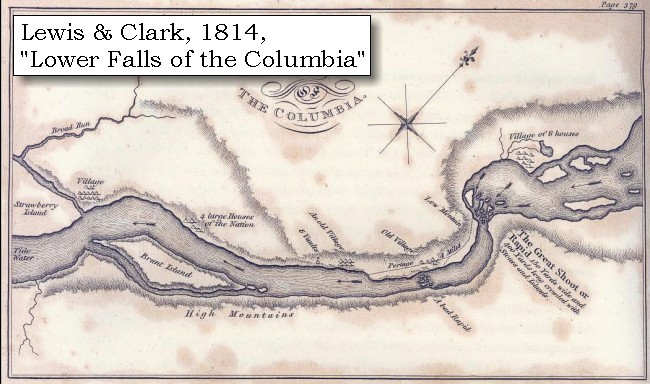
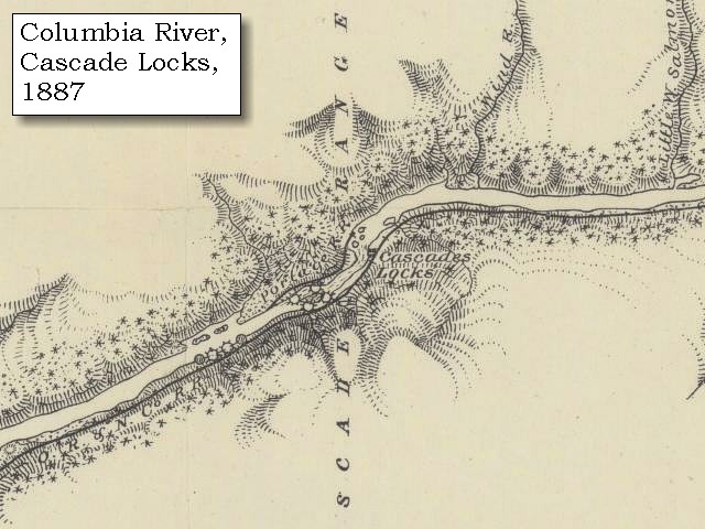
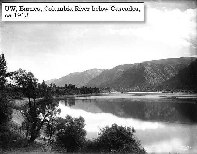
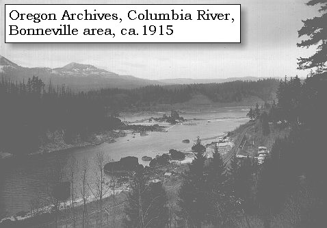
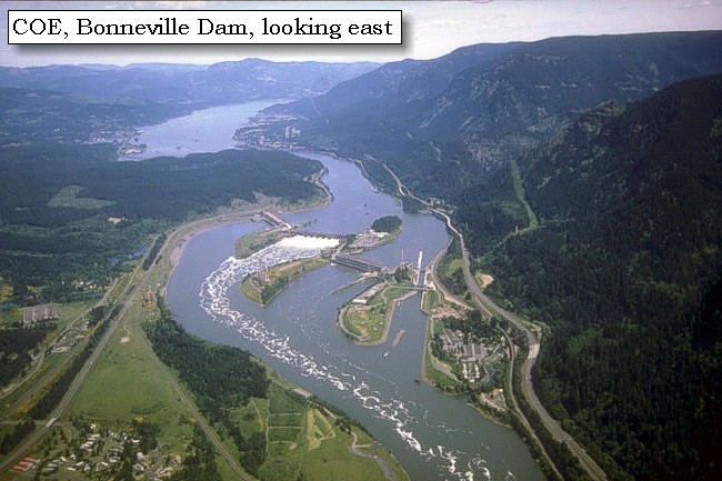
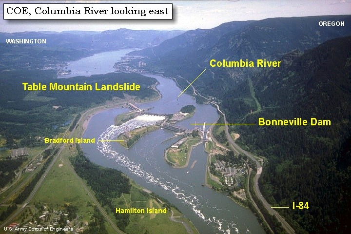
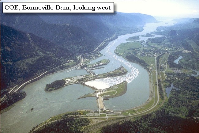
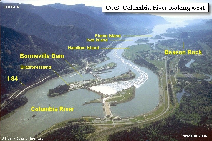
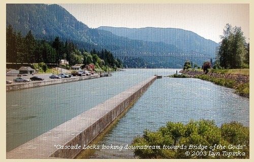
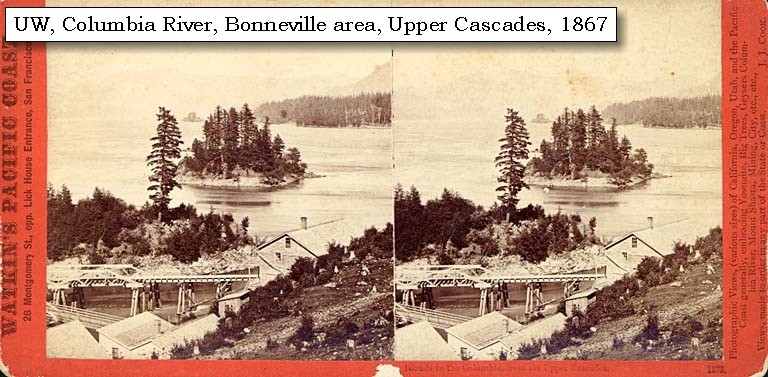
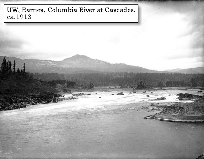
"Lower Falls of the Columbia" and Cascade Locks:
Lewis and Clark called the area around today's Cascades Locks "the Lower Falls of the Columbia" -- the Celilo Falls area was known as the "Great Falls of the Columbia". Throughout time, the area became known as the "Cascades", and in 1825, John Work of the Hudson's Bay Company was the first to record the place name, "Cascades," to describe these falls in the Columbia. Four and a half miles long, the Cascades of the Columbia were separated into two sections. The first made a bend around a rocky point on the Oregon shore, then went into a 2,000-foot-long pitch in the river and a 21-foot drop. This was called the Upper Cascade. The rest of the contracted waterway, the Lower Cascade, was a long three-and-a-half-mile pitch in the river. The total fall of the river from the head of Upper Cascade to the bottom of Lower Cascade was 45 feet at high water and 36 feet at low water. Lewis and Clark first portaged around the "Lower Falls of the Columbia" in 1805, on their journey to the Pacific. Forty years later the pioneers traveling the water route on the Oregon Trail made the same portage. In 1850 a road was built on the north side of the Columbia to portage around the rapids, and a small settlement developed to help travelers around the rapids, first by foot and then by mule-drawn rail cars. In 1864, the first steam engine in the Northwest carried passengers and freight past the rapids. In 1896 a 3,000-foot-long navigational canal with locks was completed and the modern-day town of Cascade Locks developed. The Cascades and the early locks were flooded by backwater from Bonneville Dam in 1937. -- "www.cascadelocks.net" Website, 2004, and Washington State Historical Society Website, 2004, "Lasting Legacy".


Map, 1814, Lower Falls of the Columbia, click to enlarge Map, 1854, Columbia River, Fort Vancouver area, click to enlarge Map, 1887, Cascade Locks vicinity, click to enlarge Map, 1911 USGS topo map of Cascade Locks to Bonneville area, click to enlarge Map, 1985, Bonneville to Cascade Locks, Oregon, click to enlarge Stereo Image, 1867, near the Upper Cascaldes, click to enlarge Image, ca.1913, Columbia River at the Cascades, click to enlarge Image, ca.1913, Columbia River, Oregon banks, at Cascade Locks, click to enlarge Image, 1927, Cascade Locks, click to enlarge Image, 1929, Cascade Locks, click to enlarge Image, 1934, Cascades Rapids, click to enlarge Image, 2003, Cascade Locks looking downstream
  1. 1814 Map, Lower Falls of the Columbia, by Lewis and Clark. (Click to enlarge). This map is found in Travels to the source of the Missouri River and across the American continent to the Pacific Ocean : performed by order of the government of the United States, in the years 1804, 1805, and 1806, by Captains Lewis and Clarke. Published from the official report, 1814. -- Washington State University Library Archives Website, 2002
  2. 1853-54 Map, Columbia River, including the Fort Vancouver area (section of original). (Click to enlarge). Includes Longview, Washington (Monticello), Coweeman River (Minter R.), Kalama River (Ca-la-ma R.), Lewis River (Cath-la-pootle R.), Willamette River, Fort Vancouver, Cape Horn, and "The Cascades". Vancouver Lake is depicted but not labeled. Original Map: "Rocky Mountains to Puget Sound : from explorations and surveys / made under the direction of the Hon. Jefferson Davis, Secretary of War by Isaac I. Stevens Governor of Washington Territory, 1853-4." Inset: (Supplementary sketch) Reconnaissance of the railroad route from Wallawalla to Seattle via Yak-e-mah River & Snoqualmie Pass. By A. W. Tinkham in January 1854. Drawn by J. R. P. Mechlin. 20 x 28 cm. Topographer, John Lambert, Published in Washington D.C., 1859, 1:1,200,000, Notes: From the U.S. War Department, Explorations and Surveys for a Railroad Route from the Mississippi River to the Pacific Ocean, Topographical Maps, to Illustrate the Various Reports, U.S. Library of Congress American Memories Reference "LC Railroad Maps #156". -- U.S. Library of Congress, American Memories Website, 2004
  3. 1887 Map (section of original), Columbia River and the Cascade Locks vicinity. (Click to enlarge). Original Map: The Columbia River from Celilo to the mouth showing locations of the salmon fisheries, 1887. Scale ca. 1:375,000, Relief shown by hachures. U.S. Army Corps of Engineers, Engineer Office, G.P.O. 1888. University of Washington Archives #UW128. -- University of Washington Library Archives Website, 2002
  4. 1911 Map (section of original), from Mount Hood and Vicinity 1:125,000 topographic quadrangle. (Click to enlarge). Original map surveyed in 1907 and 1909-1911, contour interval of 100 feet. -- University of Washington Library Collections Website, 2002
  5. 1985 Map (section of original), Bonneville to Cascade Locks, Oregon. (Click to enlarge). Office of Coast Surveys, Historical Maps and Charts, Columbia River, Bonneville to The Dalles, 1985, Chart#18531, 1:40,000. -- NOAA Office of Coast Survey Website, 2004
  6. 1867, Stereo view, near the Upper Cascades. (Click to enlarge). Caption on image: Islands in the Columbia from the Upper Cascades. Photographer: Carleton E. Watkins. Photo Date: 1867. University of Washington Sterocard Collection #STE043, Stereocard Collection No. 58. -- University of Washington Libraries Collection Website, 2003
  7. ca.1913, Columbia River at Cascade Locks. (Click to enlarge). Greenleaf Peak is visible in the distance. Photo by Albert Henry Barnes, ca.1913. University of Washington A.H. Barnes Collection #BAR020. -- University of Washington Library Archives, 2003
  8. ca.1913, Columbia River and Oregon banks, at Cascade Locks. (Click to enlarge). Photo by Albert Henry Barnes, ca.1913. University of Washington A.H. Barnes Collection #BAR038. -- University of Washington Library Archives, 2003
  9. 1927 aerial view, Cascade Locks. (Click to enlarge). A Burner from Wind River Mill entering Cascade Locks, Oregon. U.S. Army Corps of Engineers Archives #700-41. Photograph Date: August 1927. -- U.S. Army Corps of Engineers Website, 2002
  10. 1929 aerial view, Cascade Locks. (Click to enlarge). U.S. Army Corps of Engineers Archives. Photograph Date: September 8, 1929. -- U.S. Army Corps of Engineers Website, 2002
  11. 1934, Cascades Rapids. (Click to enlarge). From Bridge of the Gods showing the Cascade Rapids looking upstream. U.S. Army Corps of Engineers Photograph #700-40. Photograph Date: March 29, 1934. -- U.S. Army Corps of Engineers Website, 2002
  12. 2003, Cascade Locks looking downstream towards Bridge of the Gods. (Click to enlarge). Copyright © 2003 Lyn Topinka, private archives, used with permission.


Bridge of the Gods, 2003

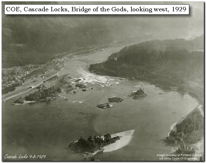
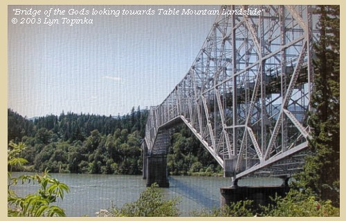
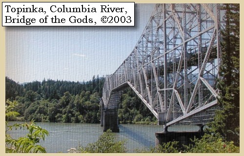
Bridge of the Gods:
About 1100 A.D., the lava layers making up Table Mountain slid into the Gorge in a series of four landslides covering five square miles, and temporarily blocked the Columbia River. Native American legend tells of crossing the river on dry land, giving rise to the "Bridge of the Gods". Today's man-made Bridge of the Gods was completed in October 1926. The cantilever structure length is 1,131 feet long with overall bridge length of 1,858 feet. Its width is 35 feet. The bridge was raised in 1938 to accomodate the rising waters behind the Bonneville Dam, and today rises 135 feet above the Bonneville pool. In 1961 the Bridge of the Gods was purchased by the Port of Cascade Locks and has been operated and maintained by the Port since that time. The Bridge of the Gods is the third oldest bridge on the Columbia River and plays a major role in the Pacific Crest Trail by linking Oregon and Washington states. -- "www.cascadelocks.net" Website, 2004, and Swanson, et.al., 1989.


Map, 1814, Lower Falls of the Columbia, click to enlarge Map, 1929 USGS topo map of the Cascade Locks area showing Bridge of the Gods, click to enlarge Map, 1985, Bonneville to Cascade Locks, Oregon, click to enlarge Image, 1926, Bridge of the Gods, click to enlarge Image, 1929, Cascade Locks, click to enlarge Image, 2003, Bridge of the Gods looking across at Bonneville Landslide
  1. 1814 Map, Lower Falls of the Columbia, by Lewis and Clark. (Click to enlarge). This map is found in Travels to the source of the Missouri River and across the American continent to the Pacific Ocean : performed by order of the government of the United States, in the years 1804, 1805, and 1806, by Captains Lewis and Clarke. Published from the official report, 1814.
  2. 1929 Map (section of original), from Hood River 1:125,000 topographic quadrangle. (Click to enlarge). Original map surveyed in 1925-26, contour interval of 100 feet. This 1929 map shows a section of the 1911 map above (see Cascade Locks) with the location of the Bridge of the Gods. The Bridge of the Gods was built in 1926. -- University of Washington Library Collections Website, 2002
  3. 1985 Map (section of original), Bonneville to Cascade Locks, Oregon. (Click to enlarge). Office of Coast Surveys, Historical Maps and Charts, Columbia River, Bonneville to The Dalles, 1985, Chart#18531, 1:40,000. -- NOAA Office of Coast Survey Website, 2004
  4. 1926, Bridge of the Gods. (Click to enlarge). This bridge takes its name from an Indian myth describing a large natural rock bridge over the Columbia River along the Oregon-Washington border. Built by the Wauna Toll Bridge Company of Walla Walla, Washington, the original bridge was 1,127 feet long. When the Bonneville Dam was constructed the structure was raised and lengthened to accommodate the rising water level. The bridge is significant not only as a fine example of cantilever technology and as a major crossing of the Columbia River, but also because of its location in the Columbia River Gorge. -- Oregon Department of Transportation Website, 2002
  5. 1929 aerial view looking downstream at Cascade Locks and Bridge of the Gods. (Click to enlarge). Washington State is on the right and Oregon is on the left. U.S. Army Corps of Engineers Historical Archives. Photograph Date: September 8, 1929. -- U.S. Army Corps of Engineers Website, 2002
  6. 2003, Bridge of the Gods, looking across towards the Bonneville Landslide, Washington State. (Click to enlarge). Copyright © 2003 Lyn Topinka, private archives, used with permission.


This morning as we were drawing the fifth canoe round a projecting rock, against which the current sets with great violence, she unfortunately offered too much of her side to the stream. It then drove her with such force, that with all the exertions of the party we were unable to hold her, and were forced to let go the cord, and see her drift down the stream, and be irrecoverably lost. We then began to carry our effects across the portage, but as all those who had short rifles took them in order to repel any attack from the Indians, it was not until five o'clock in the afternoon that the last of the party reached the head of the rapids, accompanied by our new friend the Wahclellah chief. The afternoon being so far advanced, and the weather rainy and cold, we determined to halt for the night, though very desirous of going on, for during the three last days we have not advanced more than seven miles. The portage is two thousand eight hundred yards, along a narrow road, at all times rough, and now rendered slippery by the rain. ......


Along the Journey - April 12, 1806
The Camp - April 12, 1806:
Washington side of the Columbia River, above the Cascade Locks.


Home Previous Continue


If you have questions or comments please contact: GS-CVO-WEB@usgs.gov
June/July 2004, Lyn Topinka
The Volcanoes of Lewis and Clark Home Page | CVO Home Page