Mount Adams, Washington:
Mount Adams, one of the largest volcanoes in the Cascade Range (12,276 feet), dominates the Mount Adams volcanic field in Skamania, Yakima, Klickitat, and Lewis counties of Washington State, and the Yakima Indian Reservation of south-central Washington. The nearby Indian Heaven and Simcoe Mountains volcanic fields lie west and southeast, respectively, of the 500 square miles Adams field. Even though Mount Adams has been less active during the past few thousand years than neighboring Mounts St. Helens, Rainier, and Hood, it assuredly will erupt again. Future eruptions will probably occur more frequently from vents on the summit and upper flanks of Mount Adams than from vents scattered in the volcanic fields beyond. Large landslides and lahars that need not be related to eruptions probably pose the most destructive, far-reaching hazard of Mount Adams.
The last 10,000 Years:
During the past 10,000 years, the steep upper slopes of Mount Adams have produced several notable debris avalanches. In 1921, about 5 million cubic yards of altered rock fell from the head of Avalanche Glacier on the southwest flank of the volcano and traveled almost 4 miles down Salt Creek valley. The debris avalanche contained or acquired sufficient water to partly transform into small lahars.
Ancient debris avalanches have also occurred at Mount Adams, and these formed lahars that traveled far down the White Salmon and other valleys. An avalanche of roughly 90 million cubic yards of debris initiated the largest of these lahars about 6,000 years ago. This lahar inundated the Trout Lake lowland and continued down the valley of the White Salmon River at least as far as Husum, more than 35 miles from Mount Adams. The lahar deposit left in the lowland varies from 3 to 65 feet thick -- it is clearly visible today as a sediment layer in the banks of the White Salmon River and as isolated blocks (some more than 16 feet in diameter) that protrude from fields and meadows.
The Latest Eruption:
Approximately 1,000 years ago, four tephra falls and perhaps small lava flows occurred from two vents on upper flanks of Mount Adams.
"Presidential Range":
Mount Adams was named after the 2nd President of the United States, John Adams.
a name which survives from an 1839 scheme by Hall J. Kelly to make the Cascades the Presidential Range. Kelly intended the name Adams to go to Mount Hood -- he left the mountain in Washington out of the plan entirely. However, the person who mapped the mountains mixed up Kelly's names and put the name Mount Adams 40 miles in the wrong direction -- where there happened to be a mountain ready to bear the name. "Mount Adams" stuck firmly after 1853, when the Pacific Railroad Expedition put the name on their map.

- Map, "Lewis and Clark Volcano Sitings"
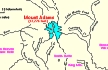
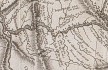
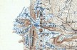
- 1999 Map, Mount Adams and Vicinity, with major river drainages. (Click to enlarge).
The headwaters of the Lewis River are shown on the left of the map.
Map also includes the Wind River, Little White Salmon River,
White Salmon River, and Klickitat River which flow into the Columbia River.
Map modified from Vallance, 1999, USGS Bulletin 2161.
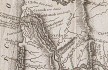
- 1814 Map, Lewis and Clark's map of the Columbia River (section of original). (Click to enlarge.)
Includes three of the five volcanoes Lewis and Clark saw and commented on. While the journals mention the expedition seeing Mount Adams, it does not appear on their map. Mount Jefferson is to the south (bottom) and off the map.
From the "Nicholas Biddle/Paul Allen" 1814 publication.
Original Map: "A Map of Lewis and Clark's Track, Across the Western Portion of North America, From the Mississippi to the Pacific Ocean".
From: History of the expedition under the command of Captains Lewis and Clark : to the sources of the Missouri, thence across the Rocky Mountains and down the river Columbia to the Pacific Ocean : performed during the years 1804-5-6 : by order of the government of the United States / prepared for the press by Paul Allen. Philadelphia : Bradford and Insskeep, 1814.
Harold B. Lee Library, Brigham Young University #upbover maps37.
-- Brigham Young University, Harold B. Lee Library Website, 2004.
- 1814 Map, Lewis and Clark's map of the Columbia River (section of original). (Click to enlarge.)
Map includes three of the five volcanoes Lewis and Clark saw and commented on. While the journals mention the expedition seeing Mount Adams, it does not appear on their map. Mount Jefferson is just visible to the south (bottom) and Mount Rainier is to the north but off the map.
From the "Nicholas Biddle/Paul Allen" 1814 publication.
Original Map: "A Map of Lewis and Clark's Track, Across the Western Portion of North America, From the Mississippi to the Pacific Ocean".
From: History of the expedition under the command of Captains Lewis and Clark : to the sources of the Missouri, thence across the Rocky Mountains and down the river Columbia to the Pacific Ocean : performed during the years 1804-5-6 : by order of the government of the United States / prepared for the press by Paul Allen. Philadelphia : Bradford and Insskeep, 1814.
Harold B. Lee Library, Brigham Young University #upbover maps37.
-- Brigham Young University, Harold B. Lee Library Website, 2004.
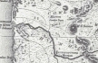
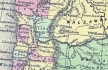
- 1833 Map (section of original), Columbia River. (Click to enlarge).
Includes Mount Hood and Mount Jefferson. Note: Mount Baker is depicted (upper middle) but Mounts Adams, Rainier and St. Helens are missing. The Columbia River is shown as "Oregon River" at its mouth and "Columbia or Oregon R." further inland. "Wappatoo Valley" is labeled. Also shows Fort Clatsop ("F. Clatsop or F. George"), the Willamette River ("Multnomah R."), Sandy River ("Quicksand R."), John Day River ("R.La Page"), Walla Walla River ("Wallwullah R."), Snake River ("Lewis R."), and the Yakima River ("Tapete R.").
Original Map: Oregon Territory, 1833.
Creator: Illman & Pilbrow, published by Illman & Pilbrow, New York.
Comments: Illman & Pilbrow is the engraving firm which copyrighted and published this map, the actual artist is unknown.
Washington State University Digital Maps Collection #WSU323.
University of Washington Digital Maps Collection #UW104.
-- Washington State University Early Washington Maps Digital Collection Website, 2004
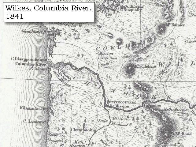
- 1841 Map (section of original), Columbia River, west. (Click to enlarge).
Includes Mount Rainier, Mount St. Helens, and Mount Hood. Mount Adams is depicted but not named.
From Wilkes, 1841, the U.S. Exploring Expedition.
-- Washington State University Early Washington Maps Digital Collection Website, 2004
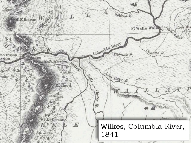
- 1841 Map (section of original), Columbia River, east. (Click to enlarge).
Includes Mount St. Helens, Mount Hood, and Mount Jefferson. Mount Adams is depicted but not named.
From Wilkes, 1841, the U.S. Exploring Expedition.
-- Washington State University Early Washington Maps Digital Collection Website, 2004
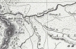
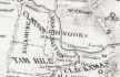
- 1853 Map, Washington and Oregon and the Columbia River,
from the Clearwater River to the Snake River and down the Columbia River to the Pacific Ocean (section of original). (Click to enlarge).
Includes: Clearwater River (Kooskooski), Lapwai Creek (Lapwai R.), Snake River (Saptin or Lewis R.), Columbia River (Columbia R.), Yakima River (Yakima R.), Walla Walla River (Wallawalla R.), Umatilla River (Umatilla R.), Willow Creek (Quesnells R.), John Day River (John Day's R.), Deschutes River (Fall R.), Willamette River (Willammette R.), and Cowlitz River (Cowlitz R.).
Original Map: "Map of California, Oregon, Washington, Utah, and New Mexico (1853)",
by Thomas Cowperthwait & Co.
Washington State University Archives #WSU22.
-- Washington State University Library Collections Website, 2003
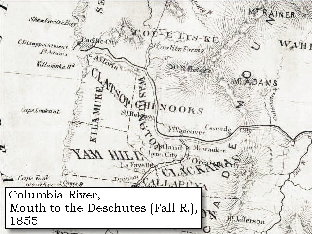
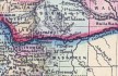
- 1855 Map, Columbia River from
Vancouver to the Pacific (section of original). (Click to enlarge).
Includes Mount Rainier, Mount St. Helens, Mount Adams, Mount Hood (depicted but not named), and Mount Jefferson.
Original Map: "Map of Oregon and Washington Territories:
showing the proposed Northern Railroad route to the Pacific Ocean,
by John Disturnell, 1855.
University of Washington Archives #UW155.
-- University of Washington Library Collections Website, 2002
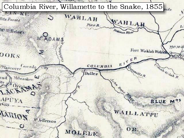
- 1855 Map, Columbia River from
Cascade Range to Walla Walla (section of original). (Click to enlarge).
Includes Mount Adams, Mount St. Helens, Mount Hood (depicted but not named), and Mount Jefferson.
Original Map: "Map of Oregon and Washington Territories:
showing the proposed Northern Railroad route to the Pacific Ocean,
by John Disturnell, 1855.
University of Washington Archives #UW155.
-- University of Washington Library Collections Website, 2002
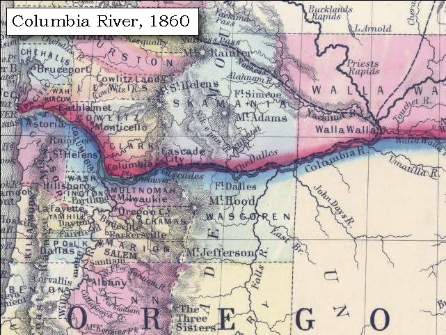
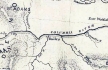
- 1860 Map, Columbia River, Washington State, and Oregon (section of original). (Click to enlarge).
Original Map: Map of Oregon, Washington, and British Columbia, (1860).
This map dates between March 2nd, 1861 (when the Dakota Territory was formed) and March 4th, 1863 (when the Idaho Territory was formed from eastern Washington and western Dakota)
Nearing retirement from a thirty year long and rather successful career, S. Augustus Mitchell printed this map showcasing Oregon, the Territory of Washington, and British Columbia. Washington became a territory in 1853, arguing that distances to Willamette Valley kept them from obtaining a voice in the Oregon territorial government. As this map shows, when it split from Oregon proper the Washington territory included parts of Wyoming and Montana and all of Idaho. Territorial government for Idaho would not be approved until 1863. When Mitchell retired he left the business for his son to manage.
Washington State University Archives #WSU7.
-- Washington State University Archives, 2004
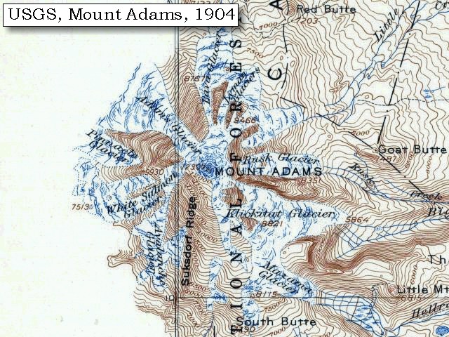
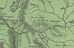
- 1904 Map of Mount Adams (section of original), from Mount Adams 1:125,000
topographic quadrangle. (Click to enlarge).
Original map surveyed in 1903-1904, contour interval of 100 feet.
-- University of Washington Library Collections Website, 2004
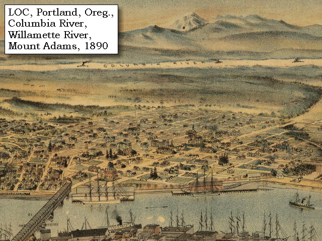
- 1879, Detail of engraving of Portland, Oregon and Mount Adams, Washington. (Click to enlarge).
The Columbia River is middleground with the Willamette River is in the foreground.
Created by E.S. Glover. Published 1879, San Francisco.
"Bird's-eye-view", looking east to the Cascade
Mountains.
Original lithograph shows Mount Rainier, Mount St.
Helens, Mount Adams, and Mount Hood, and also the
Columbia River and the Willamette River.
Reference #LC Panoramic Maps #722.
--
Library of Congress American Memories Website, 2002
- 1890, Detail from engraving of Portland, Oregon,
with Mount Adams, Washington. (Click to enlarge).
Created by Clohessy & Strengele. Published 1890, San Francisco.
"Bird's-eye-view", Portland, Oregon, 1890.
Original lithograph shows Mount St.
Helens, Mount Adams, and Mount Hood, with the
Columbia River and the Willamette River.
Reference #75694939.
--
Library of Congress American Memories Website, 2002
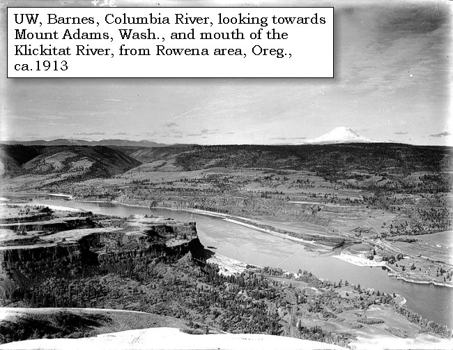
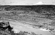
- ca.1913, Columbia River, Rowena area (Oregon), Mount Adams (Washington), and the mouth of the Klickitat River. (Click to enlarge).
Photo by Albert Henry Barnes, ca.1913.
University of Washington A.H. Barnes Collection #BAR015.
-- University of Washington Library Archives, 2003
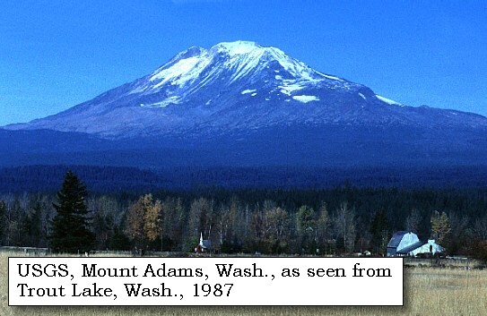
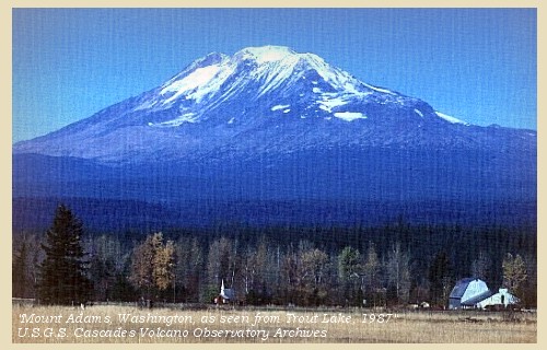
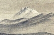
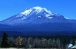
- 1987, USGS Photo showing Mount Adams, Washington, from Trout Lake (Click to enlarge).
Photographer: Lyn Topinka, Date: November 1987.
-- USGS Cascades Volcano Observatory Photo Archives, 2004
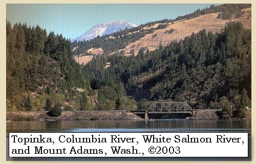
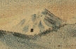
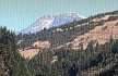
- 2003, Mount Adams, Washington, and the mouth of the White Salmon River, as seen from Hood River, Oregon. (Click to enlarge).
Copyright © 2003 Lyn Topinka, private archives, used with permission.
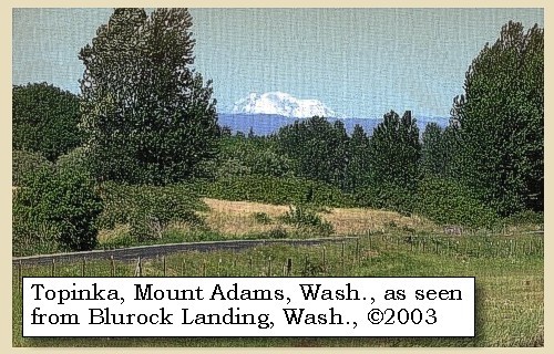
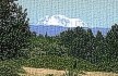
- 2003, Mount Adams, Washington as seen from Blurock Landing, Washington. (Click to enlarge). Blurock Landing is across the Columbia River from the mouth of the Willamette River, Oregon. From this location Lewis and Clark spotted five volcanoes.
Copyright © 2003 Lyn Topinka, private archives, used with permission.
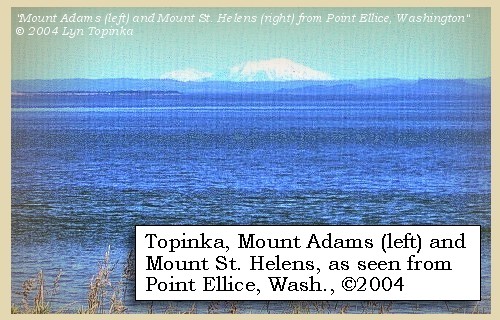
- 2004, Mount Adams (left) and Mount St. Helens, Washington, as seen from Point Ellice, Washington, 14 miles upstream from the mouth of the Columbia River. (Click to enlarge).
Copyright © 2004 Lyn Topinka, private archives, used with permission.
Excerpts from:
Scott, et.al., 1995.
"Presidential Range" information from:
Klickitat County Public Utility District Website, 2002,
Jeanie Senior interview with U.S. Forest Service archaeologist Cheryl
Mack, Mount Adams Ranger Station, Trout Lake, Washington.
|