The Volcanoes of
Lewis and Clark
November 19 - 24, 1805
At the Pacific - Station Camp, Fort Canby, Long Beach
 
Home
The Volcanoes of Lewis and Clark

Map of the Journey
Volcanoes, Basalt Plateaus, Major Rivers, etc.

The Volcanoes
Mount Adams, Mount Hood, Mount Jefferson, Mount Rainier, and Mount St. Helens

CALENDAR of the Journey
October 1805 to June 1806

Along the Journey
Pacific Northwest Maps - Columbia River, Volcanoes, Flood Basalts, Missoula Floods, Geology, etc.

The Corps of Discovery
The Journey of Lewis and Clark

About the Reference Materials
The Journals, Biddle/Allen, DeVoto, Gass, Moulton, Topo Maps, and others

USGS Lewis and Clark Links
Links to USGS Websites highlighting the Lewis and Clark Journey

Resources
Publications Referenced and Websites Visited


PREVIOUS

November 18
At the Pacific, Station Camp to Fort Canby
November 19-24

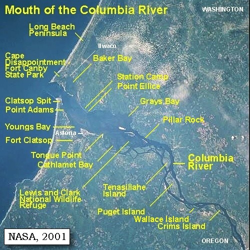
At the Pacific,
Station Camp, Fort Canby, Long Beach

Station Camp, Cape Disappointment, North Head, McKenzie Head, Fort Canby, and the Lewis and Clark Interpretive Center, Long Beach Peninsula, Columbia River Beach Sands, Leadbetter Point, Baker Bay, Wallacut River, Chinook River, and Station Camp
CONTINUE

November 25
Look for a Place to Winter, Station Camp to Pillar Rock
 

On October 7, 1805, Lewis and Clark and the "Corps of Discovery" began their journey down the Clearwater River and into the volcanics of the Pacific Northwest. The Corps travelled from the Clearwater to the Snake and down the "Great Columbia", finally reaching the Pacific Ocean on November 15, 1805. Along the journey they encountered the lava flows of the Columbia Plateau, river channels carved by the great "Missoula Floods", and the awesome beauty of five Cascade Range volcanoes.

Map, Lewis and Clark in the Pacific Northwest, click for brief
                         summary
[Click map for brief summary about the area]


To the Pacific - November 1805
At the Pacific - Station Camp, Fort Canby, Long Beach
 

On November 18, 1805, Captain Clark and 11 men began exploring the Cape Disappointment/Long Beach Peninsula area. They spent the night of November 18, 1805, camped on Cape Disappointment at the base of McKenzie Head. The main camp between November 15 through November 24, 1805, was "Station Camp", located near today's McGowan, Washington, today the site of Lewis & Clark Campsite State Park.

Tuesday, November 19, 1805
In the night it began to rain, and continued till eleven o'clock [Captain Clark's camp on Cape Disappointment, at the base of McKenzie Head]. Two hunters were sent on to kill something for breakfast, and the rest of the party after drying their blankets soon followed. At three miles we overtook the hunters, and breakfasted on a small deer, which they had been fortunate enough to kill. ......
"... began to rain a little before day and Continued raining untill 11 oClock I proceeded on thro emencely bad thickets & hills crossing 2 points to a 3rd on which we built a fire and Cooked a Deer ... from this point I can See into a Deep bend in the coast to the N.E. (N 40o E) for 10 miles. after Brackfast I proceeded on N. 20 E. 5 miles Comcement a large Sand bar at a low part ponds a little off from the Coast here the high rockey hills end and a low marshey Countrey Suckceed. ..." [Clark, November 19, 1805, first draft]


Along the Journey - November 19, 1805
Cape Disappointment, 2004

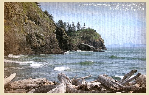
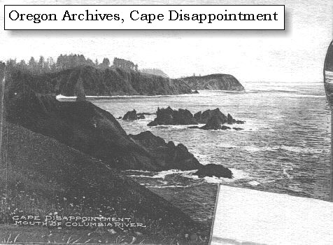
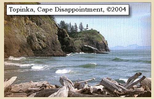
Cape Disappointment:
Cape Disappointment, the rugged north point at the Columbia River entrance, is the first major headland along the 20 miles of sand beach north from Tillamook Head. It comprises a group of rounding hills covering an area 2.5 miles long and one mile wide, divided by a narrow valley extending north-northwest. The seaward faces of these hills are precipitous cliffs with jagged, rocky points and small strips of sand beach. Lewis and Clark used the British geographical place names given by Captain John Meares, a British trading merchant, to describe the headlands at the mouth of the Columbia. In 1788 Meares was disappointed at not finding "The River of the West". When he saw the mouth of the Columbia River, he thought it was only an entrance to a bay -- thus the name Cape Disappointment. Cape Disappointment is one of the oldest British geographical place names in Washington. -- NOAA Office of Coast Survey Website, 2003, and Washington State Historical Society Website, 2002


Map, 1787, Coastline around Columbia River, click to enlarge Map, 1798, Mouth of the Columbia River, click to enlarge Map, 1814, Lewis and Clark on the Columbia, click to enlarge Map, 1849, Alexander Ross's Columbia River, click to enlarge Map, 1851, Cape Disappointment (Cape Hancock), click to enlarge Map, 1853, Washington and Oregon and the Columbia River, click to enlarge Map, 1855, Mouth of the Columbia River, click to enlarge Map, 1855, Northwest Oregon and mouth Columbia River, click to enlarge Map, 1887, Columbia River from mouth to Pillar Rock, click to enlarge Map, 1887, Cape Disappointment and Baker Bay, click to enlarge Map, 1949, Cape Disappointment, North Head, McKenzie Head, Ilwaco, click to enlarge Map, 1987, Cape Disappointment, Ilwaco, Baker Bay, click to enlarge NASA Image, 2001, Mouth of the Columbia River, click to enlarge Image, ca.1879-1909, Cape Disappointment, click to enlarge Image, 1997, Cape Disappointment, click to enlarge Image, 2004, Cape Disappointment
  1. 1787 Map, North American Coastline around the Columbia River (section of original). (Click to enlarge). Includes Cape Disappointment as "C. de San Roque". Original Map: "Carta que contiene parte de la costa de la California", by Bernabe Munoz, 1787. Scale ca.1:5,000,000. Library of Congress American Memory Archives #G4362.C6 1787 .M8 TIL Vault. -- U.S. Library of Congress Archives, 2004, "American Memory"
  2. 1798 Map, Mouth of the Columbia River (section of original). (Click to enlarge). Inset map of original, showing the mouth of the Columbia River, including Cape Disappointment, Point Adams, Youngs River, Point George (today's Astoria), and Grays Bay. Original Map: George Vancouver's "A Chart Shewing Part of the Coast of N.W. America." In A Voyage of discovery to the North Pacific ocean, and Round the World. London, 1798. University of Virginia Special Collection "Lewis & Clark, The Maps of Exploration 1507-1814". -- University of Virginia Library Archives Website, 2004
  3. 1814 Map, Lewis and Clark's map of the Columbia River (section of original). (Click to enlarge.) Shows Cape Disappointment. Map also includes three of the five volcanoes Lewis and Clark saw and commented on. While the journals mention the expedition seeing Mount Adams, it does not appear on their map. Mount Jefferson is to the south (bottom) and off the map. From the "Nicholas Biddle/Paul Allen" 1814 publication. Original Map: "A Map of Lewis and Clark's Track, Across the Western Portion of North America, From the Mississippi to the Pacific Ocean". From: History of the expedition under the command of Captains Lewis and Clark : to the sources of the Missouri, thence across the Rocky Mountains and down the river Columbia to the Pacific Ocean : performed during the years 1804-5-6 : by order of the government of the United States / prepared for the press by Paul Allen. Philadelphia : Bradford and Insskeep, 1814. Harold B. Lee Library, Brigham Young University #upbover maps37. -- Brigham Young University, Harold B. Lee Library Website, 2004.
  4. 1849 Map (section of original), Alexander Ross's Columbia River. (Click to enlarge). Original Map: Map of the Columbia to illustrate Ross's adventures. Author: Alexander Ross; Publication Date: 1849; Publisher: London, Smith, Elder and Co., 1849. Washington State University Archives #WSU478. -- Washington State University Early Washington Maps Digital Collection Website, 2004
  5. 1851 Map, Cape Disappointment, Washington (section of original). (Click to enlarge). Cape Disappointment was also known as Cape Hancock. Original Map: "Mouth of the Columbia River, Preliminary Survey, 1851". U.S. Coast Survey, 1851, #640, Scale 1:40,000. U.S. Office of Coast Survey Historical Map and Chart Collection #2228148. -- NOAA Archives Website, 2004
  6. 1853 Map, Washington and Oregon and the Columbia River, from the Clearwater River to the Snake River and down the Columbia River to the Pacific Ocean (section of original). (Click to enlarge). Includes: Clearwater River (Kooskooski), Lapwai Creek (Lapwai R.), Snake River (Saptin or Lewis R.), Columbia River (Columbia R.), Yakima River (Yakima R.), Walla Walla River (Wallawalla R.), Umatilla River (Umatilla R.), Willow Creek (Quesnells R.), John Day River (John day's R.), Deschutes River (Fall R.), Willamette River (Willammette R.), and Cowlitz River (Cowlitz R.). Original Map: "Map of California, Oregon, Washington, Utah, and New Mexico (1853)", by Thomas Cowperthwait & Co. Washington State University Archives #WSU22. -- Washington State University Library Collections Website, 2003
  7. 1855 Map, Mouth of the Columbia River, with Cape Disappointment and Long Beach Peninsula (section of original). (Click to enlarge). Original Map: "Map of a part of the Territory of Washington : to accompany report of Surveyor General (1855)". By James Tilton, Washington (State) Surveyor General's Office. Relief shown by hachures, Scale 1:1,140,480. Washington State University Historical Maps Collection #WSU314, and University of Washington Map Collection #UW114. -- Washington State University Library Archives Website, 2004
  8. 1855 Map, Northwest Oregon and mouth of the Columbia River (section of original). (Click to enlarge). Includes the Columbia River, Cape Disappointment, Point Adams, Saddle Mountain, Lewis and Clark River, Youngs River. Original Map: From the northern boundary of California to the Columbia River : from explorations and surveys / made under the direction of Hon. Jefferson Davis, Sec. of War by Lieut. R. S. Williamson, U.S. Topl. Engrs. and Lieut. H. L. Abbot, U.S. Topl. Engrs., H. C. Fillebrown, J. Young, and C. D. Anderson, Assts., 1855. Notes: Scale 1:760,320. Relief shown by hachures. At head of title: Routes in Oregon and California. Map no. 2. "Drawn by John Young." From U.S. War Department, Explorations and Surveys for a Railroad Route from the Mississippi River to the Pacific Ocean. Topographical Maps... to Illustrate the Various Reports... (Washington, 1859) Library of Congress American Memory Archives #G4290 1855 .W5 RR 170. -- U.S. Library of Congress Archives, 2004, "American Memory"
  9. 1887 Map, Columbia River from the Mouth to Pillar Rock (section of original). (Click to enlarge). Cape Disappointment is shown as Cape Hancock. Original Map: The Columbia River from Celilo to the mouth showing locations of the salmon fisheries, 1887. Scale ca. 1:375,000, Relief shown by hachures. U.S. Army Corps of Engineers, Engineer Office, G.P.O. 1888. University of Washington Archives #UW128. -- University of Washington Library Archives Website, 2004
  10. 1887, Map, Cape Disappointment and Baker Bay. (Click to enlarge). Mouth of the Columbia River showing fishtraps in Baker's Bay, 1887. U.S. Army Corps of Engineers Map, published 1888. University of Washington Map Archives #UW129. -- University of Washington Library Collections Website, 2002
  11. 1949 Map (section of original), Cape Disappointment, North Head, McKenzie Head, Fort Canby, Ilwaco. (Click to enlarge). Office of Coast Surveys, Historical Maps and Charts, Columbia River, Pacific Ocean to Harrington Point, 1949, Chart#6151, 1:40,000. -- NOAA Office of Coast Survey Website, 2004
  12. 1987 Map, Cape Disappointment, Ilwaco, Baker Bay (section of original). (Click to enlarge). Office of Coast Surveys, Historical Maps and Charts, Columbia River, Pacific Ocean to Harrington Point, 1987, Chart#18521, 1:40,000. -- NOAA Office of Coast Survey Website, 2004
  13. 2001, NASA Image, Mouth of the Columbia River, including Cape Disappointment. (Click to enlarge). NASA Space Shuttle photograph of the mouth of the Columbia River, including the location of Fort Clatsop, Lewis and Clark National Wildlife Refuge, Tenasillahe Island, Puget Island, and Crim's Island, and others, June 20, 2001. NASA Astronaut Photography of Earth #SS002-724-30. -- NASA Astronaut Photography of Earth Website, 2002
  14. ca.1879-1909, Cape Disappointment. (Click to enlarge). Pictured is a scene in the region served by the Oregon Railway & Navigation Company between 1879-1909. This is Cape Disappointment, north of the Columbia River. Photographer unknown. Oregon State Archives Salem Public Library #ORN25A. -- Oregon State Archives Website, 2003
  15. 1997, Aerial view, Cape Disappointment. (Click to enlarge). Looking at Cape Disappointment Lighthouse. Washington State Department of Ecology Shorelines Aerial Photo #PAC0547, May 10, 1997. -- Washington State Department of Ecology Website, 2002
  16. 2004, Cape Disappointment, as seen from North Spit, looking towards Cape Disappointment Lighthouse. (Click to enlarge). Copyright © 2004 Lyn Topinka, private archives, used with permission.


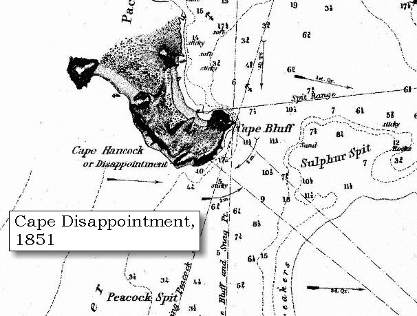
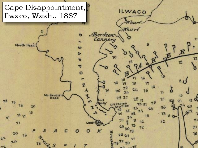
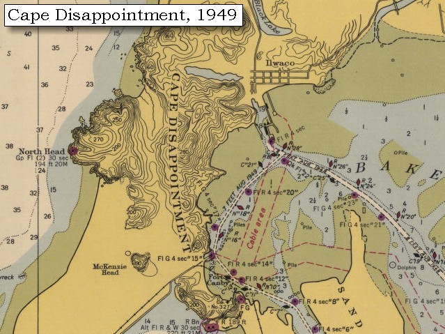
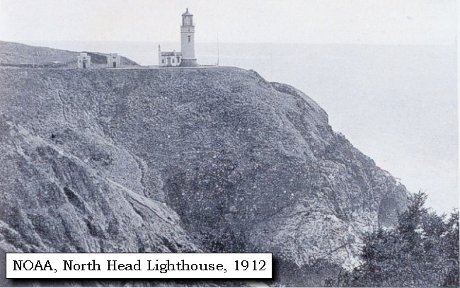
North Head:
North Head, the extreme western point of Cape Disappointment, is 170 feet high, with a very jagged, precipitous cliff, backed by a narrow grassy strip. The higher ground behind it is covered with trees. The North Head Lighthouse was built in 1898, and affords a spectacular view of the Pacific Ocean, with Benson Beach and the mouth of the Columbia River to the south and the Long Beach Peninsula stretching northward, a panoramic vista unparalleled on a clear day. -- NOAA Office of Coastal Survey website, 2003, Washington State Parks and Recreation Website, 2003, and Long Beach Area State Parks, 2002


Map, 1887, Cape Disappointment and Baker Bay, click to enlarge Map, 1949, Cape Disappointment, North Head, McKenzie Head, Ilwaco, click to enlarge Image, 1997, North Head, click to enlarge Image, 1912, North Head Lighthouse, click to enlarge
  1. 1887, Map, Cape Disappointment and Baker Bay, including McKenzie Head. (Click to enlarge). Mouth of the Columbia River showing fishtraps in Baker's Bay, 1887. U.S. Army Corps of Engineers Map, published 1888. University of Washington Map Archives #UW129. -- University of Washington Library Collections Website, 2002
  2. 1949 Map (section of original), Cape Disappointment, North Head, McKenzie Head, Fort Canby, Ilwaco. (Click to enlarge). Office of Coast Surveys, Historical Maps and Charts, Columbia River, Pacific Ocean to Harrington Point, 1949, Chart#6151, 1:40,000. -- NOAA Office of Coast Survey Website, 2004
  3. 1997, Aerial view, North Head showing the North Head Lighthouse. (Click to enlarge). Washington State Department of Ecology Shorelines Aerial Photo #PAC0533, May 10, 1997. -- Washington State Department of Ecology Website, 2002
  4. 1912, North Head Lighthouse. (Click to enlarge). Original from: "Puget Sound and Western Washington Cities-Towns Scenery" by Robert A. Reid, Robert A. Reid Publisher, Seattle, 1912. Archival photograph by Steve Nicklas, NGS/RSD. Image from the NOAA Photo Archives Coastline Collection #line2186. -- NOAA Photo Archives Website, 2002


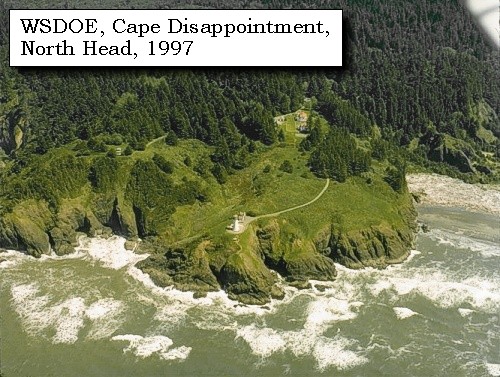
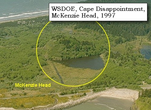
McKenzie Head:
McKenzie Head is located 0.8 miles northwest of Cape Disappointment Light. It is 190 feet high and nearly round. On its seaward face it is covered with grass and fern, bare of trees. On its eastern face it is heavily wooded with spruce. -- NOAA Office of Coast Survey Website, 2003


Map, 1887, Cape Disappointment and Baker Bay, click to enlarge Map, 1949, Cape Disappointment, North Head, McKenzie Head, Ilwaco, click to enlarge Image, 1997, McKenzie Head, click to enlarge
  1. 1887, Map, Cape Disappointment and Baker Bay, including McKenzie Head. (Click to enlarge). Mouth of the Columbia River showing fishtraps in Baker's Bay, 1887. U.S. Army Corps of Engineers Map, published 1888. University of Washington Map Archives #UW129. -- University of Washington Library Collections Website, 2002
  2. 1949 Map (section of original), Cape Disappointment, North Head, McKenzie Head, Fort Canby, Ilwaco. (Click to enlarge). Office of Coast Surveys, Historical Maps and Charts, Columbia River, Pacific Ocean to Harrington Point, 1949, Chart#6151, 1:40,000. -- NOAA Office of Coast Survey Website, 2004
  3. 1997, Aerial view, McKenzie Head. (Click to enlarge). Washington State Department of Ecology Shorelines Aerial Photo #PAC0544, May 10, 1997. -- Washington State Department of Ecology Website, 2002


Fort Canby:
In 1862, Cape Disappointment was armed with smoothbore cannons to protect the mouth of the Columbia River from enemies. The installation was expanded to become Fort Canby in 1875. The fort was named after General Edward Canby, who was killed in the Modoc Indian War. The fort continued to be improved until the end of World War II. Gun batteries still sit uptop the park. Today Cape Disappointment State Park (formerly Fort Canby State Park) is a 1,882-acre camping park which offers 27 miles of ocean beach, two lighthouses, an interpretive center and hiking trails. Visitors enjoy beachcombing and exploring the area's rich natural and cultural history. The nearby coastal towns of Ilwaco and Long Beach feature special events and festivals spring through fall. -- Washington State Parks and Recreation Website, 2002


Map, 1949, Cape Disappointment, North Head, McKenzie Head, Ilwaco, click to enlarge NASA Image, 2001, Mouth of the Columbia River, click to enlarge Image, 1997, Fort Canby State Park, click to enlarge
  1. 1949 Map (section of original), Cape Disappointment, North Head, McKenzie Head, Fort Canby, Ilwaco. (Click to enlarge). Office of Coast Surveys, Historical Maps and Charts, Columbia River, Pacific Ocean to Harrington Point, 1949, Chart#6151, 1:40,000. -- NOAA Office of Coast Survey Website, 2004
  2. 2001, NASA Image, Mouth of the Columbia River, including Fort Canby State Park. (Click to enlarge). NASA Space Shuttle photograph of the mouth of the Columbia River, including the location of Fort Clatsop, Lewis and Clark National Wildlife Refuge, Tenasillahe Island, Puget Island, and Crim's Island, and others, June 20, 2001. NASA Astronaut Photography of Earth #SS002-724-30. -- NASA Astronaut Photography of Earth Website, 2002
  3. 1997, Aerial view, Fort Canby State Park. (Click to enlarge). Washington State Department of Ecology Shorelines Aerial Photo #PAC0546, May 10, 1997. -- Washington State Department of Ecology Website, 2002


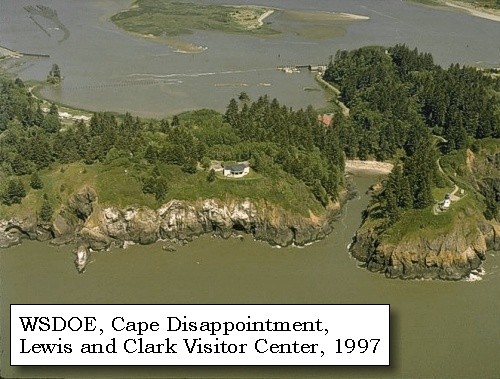
Lewis and Clark Interpretive Center:
In November of 1805, the U.S. Corps of Volunteers for Northwest Discovery, led by Meriwether Lewis and William Clark, reached the mouth of the mighty Columbia River and the Pacific Ocean at last. "Great joy in camp," Clark wrote in his journal, "we are in View of the Ocian, this great Pacific Ocian which we been So long anxious to See." Today the Lewis and Clark Interpretive Center stands high on the cliffs of Fort Canby State Park, 200 feet above the pounding Pacific surf. A series of mural-sized "timeline" panels guide visitors through the westward journey of the Lewis and Clark Expedition using sketches, paintings, photographs and the words of Corps members themselves. The center also features short film presentations, a gift shop and a glassed-in observation deck with fabulous views of the river, headlands and sea. -- Washington State Parks and Recreation Website, 2003


Image, 1997, Fort Canby State Park, click to enlarge
  1. 1997, Aerial view, Fort Canby State Park and the Lewis and Clark Interpretive Center. (Click to enlarge). Washington State Department of Ecology Shorelines Aerial Photo #PAC0546, May 10, 1997. -- Washington State Department of Ecology Website, 2002


We then continued over rugged hills and steep hollows, near the sea, on a course about north 20? west, in a direct line from the cape [Cape Disappointment], till at the distance of five miles, we reached a point of high land, below which a sandy beach extends, in a direction north 10? west, [Long Beach Peninsula] to another high point about twenty miles distant. This eminence we distinguished by the name of point Lewis [Leadbetter Point].


Along the Journey - November 19, 1805
Map, mouth of the Columbia River, 1855

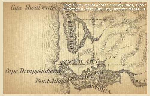
Long Beach Peninsula:
The Long Beach peninsula, a huge spit, was formed by sediments delivered to sea by the Columbia River. Waves and currents slowly reworked the sediments to build the 19 mile long peninsula which is only about a mile wide. Broad sand beaches front an upland sand plain, laced with parallel dune ridges, bogs, lakes, and woodlands. In 1805 -- long before the construction of the contemporary north jetty at the mouth of the Columbia River - the beach was approximately one mile east of its present location. Once the jetty was added, the waters of the Columbia were moved to make a more northerly turn as they joined the Pacific Ocean. This situation has led to the accretion of a significant amount of dunal land along the western edge of the Long Beach Peninsula, in some areas as much as 2,500 feet of additional land between the 'original' Peninsula and the current coastline. -- Washington State Department of Ecology Website, 2002, and Pacific County Friends of Lewis & Clark Website, 2002


Map, 1855, Mouth of the Columbia River, click to enlarge NASA Image, 2001, Mouth of the Columbia River, click to enlarge Image, 1997, Long Beach Peninsula, click to enlarge
  1. 1855 Map, Mouth of the Columbia River, with Cape Disappointment and Long Beach Peninsula (section of original). (Click to enlarge). Original Map: "Map of a part of the Territory of Washington : to accompany report of Surveyor General (1855)". By James Tilton, Washington (State) Surveyor General's Office. Relief shown by hachures, Scale 1:1,140,480. Washington State University Historical Maps Collection #WSU314, and University of Washington Map Collection #UW114. -- Washington State University Library Archives Website, 2004
  2. 2001, NASA Image, Mouth of the Columbia River, including Long Beach Peninsula. (Click to enlarge). NASA Space Shuttle photograph of the mouth of the Columbia River, including the location of Fort Clatsop, Lewis and Clark National Wildlife Refuge, Tenasillahe Island, Puget Island, and Crim's Island, and others, June 20, 2001. NASA Astronaut Photography of Earth #SS002-724-30. -- NASA Astronaut Photography of Earth Website, 2002
  3. 1997, Aerial view, Long Beach. (Click to enlarge). Washington State Department of Ecology Shorelines Aerial Photo #PAC0479, May 10, 1997. -- Washington State Department of Ecology Website, 2002


Columbia River Beach Sands:
For the past five thousand years, the Columbia River has carried sand to the coast. Currents, waves and wind have swept sand north and south -- from the Columbia River mouth to build up dunes and beaches. Millions of cubic yards of Columbia River sand are stored in these linear dunes and beaches, also called barriers. The Columbia River supplies sand to 100 miles of beaches, from Oregon's Tillamook Head to Washington's Point Grenville. As sand moves north up Washington's coast, the amount available to nourish beaches decreases. At Point Grenville, the trailing end of Columbia River sand is deposited. North of Point Grenville, the contribution of Columbia River sand to beaches is small. Beach sand from the Columbia River is made of light minerals, lithic fragments, and heavy minerals such as: hornblende, augite, hypersthene, magnetite. Some minerals come from mountains many miles away -- as far as the Rockies. -- Washington State Department of Ecology Website, 2002

Leadbetter Point:
"Point Lewis" was not seen by Clark when he conducted a reconnaissance of the seacoast north of he Columbia River. After gaining information from the local Indians on the supposed high point of land, he named it "after my particular friend Lewis." The captains did not engage in speculative creation of geography; however, sometimes they misunderstood the information they obtained. The exact geographical feature that Clark named has been identified as Leadbetter Point, North Head, and Cape Shoalwater by various authors. Clark crossed North Head and probably was describing a feature farther north on the seacoast. Cape Shoalwater, a high point-unlike the low Leadbetter Point-is farther north, on the northern side of the entrance to Willapa Bay. Meares, in 1788, described the peninsula more correctly as "Low Point" and named Cape Shoalwater. The present name for the peninsula honors Lieutenant Danville Leadbetter, a member of the United States Coast Survey in 1852. -- Washington State Historical Society Website, 2002


Image, 1997, Leadbetter point, click to enlarge
  1. 1997, Aerial view, Leadbetter Point. (Click to enlarge). Washington State Department of Ecology Shorelines Aerial Photo #PAC0443, May 10, 1997. -- Washington State Department of Ecology Website, 2002


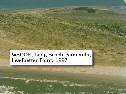
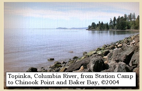
It is there that the highlands, which at the commencement of the sandy beach, recede towards Chinnook river, again approach the ocean. The intermediate country is low, with many small ponds, crowded with birds, and watered by the Chinnook [Willapa Bay, Willapa National Wildlife Refuge, and the Naselle River], on the borders of which resides the nation of the same name. We went four miles along the sandy beach to a small pine tree, on which captain Clarke marked his name, with the year and day, and then returned to the foot of the hills, passing on the shore a sturgeon ten feet long, and several joints of the back bone of a whale, both which seem to have been thrown ashore and foundered. After dining on the remains of the small deer, we crossed in a southeastern direction to the bay [Baker Bay], where we arrived at the distance of two miles, then continued along the bay,


Along the Journey - November 19, 1805
Baker Bay with Ilwaco, Washington in the distance, 2004

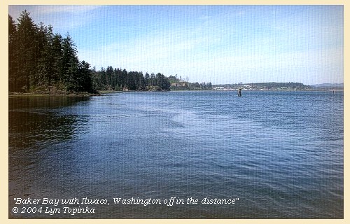
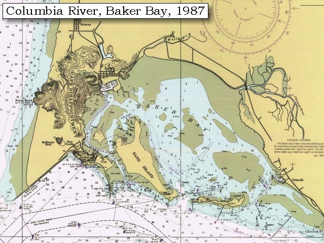
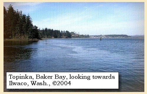
Baker Bay:
In 1792, William Broughton named the bay, "Baker's Bay," to give credit to a British merchant, Captain James Baker, whose ship was anchored inside the Columbia's mouth when Broughton crossed the bar to explore the river for Vancouver. Lewis and Clark named the bay "Haley's Bay", for the Indians' favorite trader, as reported to the captains. -- Washington State Historical Society Website, 2002


Map, 1814, Lewis and Clark on the Columbia, click to enlarge Map, 1887, Mouth of the Columbia River, click to enlarge Map, 1887, Cape Disappointment and Baker Bay, click to enlarge Map, 1987, Cape Disappointment, Ilwaco, Baker Bay, click to enlarge NASA Image, 2001, Mouth of the Columbia River, click to enlarge Image, 2004, Downstream from Station Camp Image, 2004, Baker Bay and Ilwaco, Washington
  1. 1814 Map, Lewis and Clark's map of the Columbia River (section of original). (Click to enlarge.) Baker Bay is just barely depicted on the map, and has no clear definition (just east of Cape Disappointment). Map also includes three of the five volcanoes Lewis and Clark saw and commented on. While the journals mention the expedition seeing Mount Adams, it does not appear on their map. Mount Jefferson is to the south (bottom) and off the map. From the "Nicholas Biddle/Paul Allen" 1814 publication. Original Map: "A Map of Lewis and Clark's Track, Across the Western Portion of North America, From the Mississippi to the Pacific Ocean". From: History of the expedition under the command of Captains Lewis and Clark : to the sources of the Missouri, thence across the Rocky Mountains and down the river Columbia to the Pacific Ocean : performed during the years 1804-5-6 : by order of the government of the United States / prepared for the press by Paul Allen. Philadelphia : Bradford and Insskeep, 1814. Harold B. Lee Library, Brigham Young University #upbover maps37. -- Brigham Young University, Harold B. Lee Library Website, 2004.
  2. 1887 Map (section of original), Mouth of the Columbia River. (Click to enlarge). Original Map: The Columbia River from Celilo to the mouth showing locations of the salmon fisheries, 1887. Scale ca. 1:375,000, Relief shown by hachures. U.S. Army Corps of Engineers, Engineer Office, G.P.O. 1888. University of Washington Archives #UW128. -- University of Washington Library Archives Website, 2002
  3. 1887, Map, Cape Disappointment and Baker Bay. (Click to enlarge). Mouth of the Columbia River showing fishtraps in Baker's Bay, 1887. U.S. Army Corps of Engineers Map, published 1888. University of Washington Map Archives #UW129. -- University of Washington Library Collections Website, 2002
  4. 1987 Map, Cape Disappointment, Ilwaco, Baker Bay (section of original). (Click to enlarge). Office of Coast Surveys, Historical Maps and Charts, Columbia River, Pacific Ocean to Harrington Point, 1987, Chart#18521, 1:40,000. -- NOAA Office of Coast Survey Website, 2004
  5. 2001, NASA Image, Mouth of the Columbia River, including Baker Bay. (Click to enlarge). NASA Space Shuttle photograph of the mouth of the Columbia River, including the location of Fort Clatsop, Lewis and Clark National Wildlife Refuge, Tenasillahe Island, Puget Island, and Crim's Island, and others, June 20, 2001. NASA Astronaut Photography of Earth #SS002-724-30. -- NASA Astronaut Photography of Earth Website, 2002
  6. 2004, From Station Camp, looking downstream. Chinook Point is in the distance, with Baker Bay and Cape Disappointment at skyline. (Click to enlarge). Copyright © 2004 Lyn Topinka, private archives, used with permission.
  7. 2004, Looking across western end of Baker Bay towards Ilwaco, Washington. (Click to enlarge). Image taken from Cape Disappointment. Copyright © 2004 Lyn Topinka, private archives, used with permission.


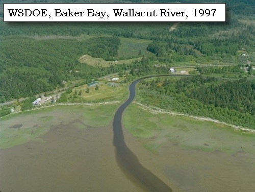
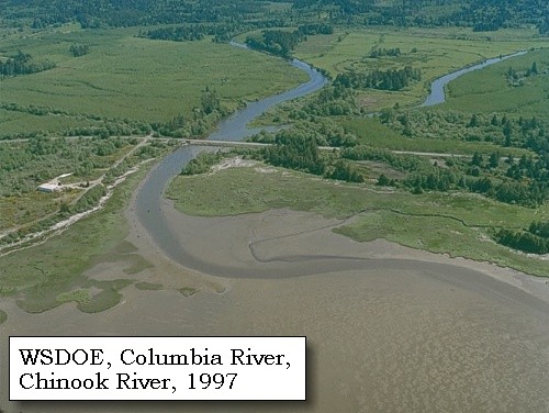
crossed Chinnook river [Wallacut River], and encamped on its upper side, in a sandy bottom.


Along the Journey - November 19, 1805
Map, Wallacut and Chinook Rivers, 1905

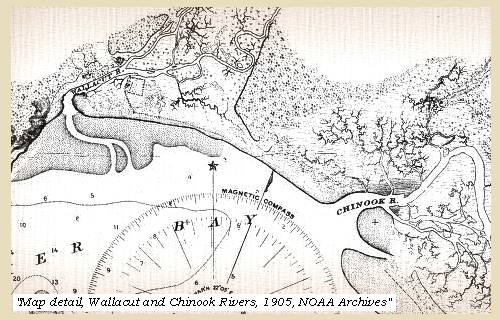
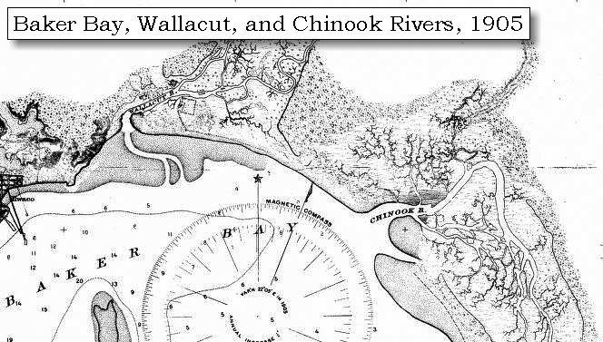
Wallacut River:
Errors created in transferring information from the journals to maps become apparent when studying the names the captains applied to this drainage. "White Brant Creek" was intended to be applied to the most westerly drainage into "Haley's Bay." "Chinook River" is charted for the watershed on one of Clark's maps, and he called the river by the same name when he camped near it while returning from the coast. Conjecture and second-hand information may have confused the captains. This drainage was used by the Chinook Indians to reach their winter village, but Clark intended the drainage near the Indians' summer village to be named after its inhabitants. "Knights River" was used by HBC employees to identify the drainage. The present place name for the river came from the Chinook Indian word, "Walihut," meaning "place of stones." Near the mouth of the river, the north bank has many small, smooth boulders. -- Washington State Historical Society Website, 2002


Map, 1887, Columbia River from mouth to Pillar Rock, click to enlarge Map, 1905, Wallacut and Chinook Rivers, click to enlarge Map, 1987, Cape Disappointment, Ilwaco, Baker Bay, click to enlarge Image, 1997, Wallacut River, click to enlarge
  1. 1887 Map, Columbia River from the Mouth to Pillar Rock (section of original). (Click to enlarge). The Wallacut River (at Ilwaco) is depicted but not named. Original Map: The Columbia River from Celilo to the mouth showing locations of the salmon fisheries, 1887. Scale ca. 1:375,000, Relief shown by hachures. U.S. Army Corps of Engineers, Engineer Office, G.P.O. 1888. University of Washington Archives #UW128. -- University of Washington Library Archives Website, 2004
  2. 1905 Map, Wallacut and Chinook Rivers, Washington (section of original). (Click to enlarge). Original Map: "Columbia River, Sheet No.1, Entrance to Upper Astoria". U.S. Coast Survey, 1905, #6140, Scale 1:40,000. U.S. Office of Coast Survey Historical Map and Chart Collection #3853659. -- NOAA Archives Website, 2004
  3. 1987 Map, Cape Disappointment, Ilwaco, Baker Bay (section of original). (Click to enlarge). Office of Coast Surveys, Historical Maps and Charts, Columbia River, Pacific Ocean to Harrington Point, 1987, Chart#18521, 1:40,000. -- NOAA Office of Coast Survey Website, 2004
  4. 1997, Aerial view, Wallacut River. (Click to enlarge). Washington State Department of Ecology Shorelines Aerial Photo #PAC0581, May 13, 1997. -- Washington State Department of Ecology Website, 2002


Along the Journey - November 19, 1805
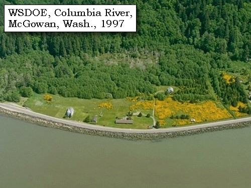
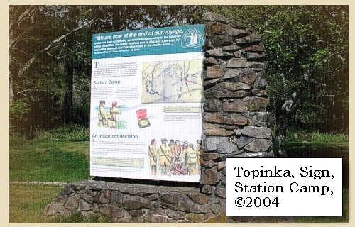
The Main Camp - November 15 through November 24, 1805:
"Station Camp", near today's McGowan, Washington.


Clark's Camp:
Upstream of the Wallacut River.


Wednesday, November 20, 1805
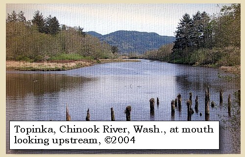
It rained in the course of the night. A hunter despatched early to kill some food, returned with eight ducks, on which we breakfasted, and then followed the course of the bay [Baker Bay] to the creek or outlet of the ponds [Chinook River]. It was now high tide, the stream three hundred yards wide, and no person in the cabin to take us across. We therefore made a small raft, on which one of the men passed and brought a canoe to carry us over.


Along the Journey - November 20, 1805
Chinook River, 2004

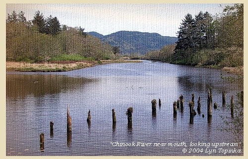
Chinook River:
There is an inconsistency between the maps and journals when trying to determine the names Lewis and Clark applied to two rivers that drained into "Haley's Bay." "White Brant Creek" and "Chinook River" are labeled differently on Clark's maps of the Columbia's mouth. He also misidentified the rivers when he went on a sojourn to the coast with 11 men. He probably intended the "Chinook River" to be applied to the drainage close to the village of that native nation. -- Washington State Historical Society Website, 2002


Map, 1887, Columbia River from mouth to Pillar Rock, click to enlarge Map, 1905, Wallacut and Chinook Rivers, click to enlarge Map, 1987, Cape Disappointment, Ilwaco, Baker Bay, click to enlarge Image, 1997, Chinook River, click to enlarge Image, 2004, Chinook River, Washington
  1. 1887 Map, Columbia River from the Mouth to Pillar Rock (section of original). (Click to enlarge). The mouth of the Chinook River (left of Chinook Point) is depicted but not named. Original Map: The Columbia River from Celilo to the mouth showing locations of the salmon fisheries, 1887. Scale ca. 1:375,000, Relief shown by hachures. U.S. Army Corps of Engineers, Engineer Office, G.P.O. 1888. University of Washington Archives #UW128. -- University of Washington Library Archives Website, 2004
  2. 1905 Map, Wallacut and Chinook Rivers, Washington (section of original). (Click to enlarge). Original Map: "Columbia River, Sheet No.1, Entrance to Upper Astoria". U.S. Coast Survey, 1905, #6140, Scale 1:40,000. U.S. Office of Coast Survey Historical Map and Chart Collection #3853659. -- NOAA Archives Website, 2004
  3. 1987 Map, Cape Disappointment, Ilwaco, Baker Bay (section of original). (Click to enlarge). Office of Coast Surveys, Historical Maps and Charts, Columbia River, Pacific Ocean to Harrington Point, 1987, Chart#18521, 1:40,000. -- NOAA Office of Coast Survey Website, 2004
  4. 1997, Aerial view, Chinook River. (Click to enlarge). Washington State Department of Ecology Shorelines Aerial Photo #PAC0591, May 13, 1997. -- Washington State Department of Ecology Website, 2002
  5. 2004, Chinook River, Washington, looking upstream from near mouth. (Click to enlarge). Copyright © 2004 Lyn Topinka, private archives, used with permission.


As we went along the beach we were overtaken by several Indians, who gave us dried sturgeon and wappatoo roots, and soon met several parties of Chinnooks returning from the camp [Station Camp, near McGowan, Washington]. ......


Along the Journey - November 20, 1805
Station Camp, 2004

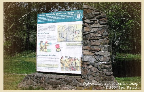
Station Camp:
"Station Camp" was near a Chinook fishing village. At the highest spot they could find, the Corps landed and, using boards from the village houses, created a campsite which they named "Station Camp." Early photographs of this area, now called McGowan, indicate that the shoreline was as much as several hundred feet south of the present location on US 101. There is a current small roadside park just west of St. Mary's Church in the general area, but this is not the actual location of the campsite. -- Pacific County Friends of Lewis & Clark Website, 2002, Lewis and Clark Bicentennial in Oregon Website, 2002, and Washington State Historical Society Website, 2002


Map, 1987, Chinook Point, McGowan, Station Camp, Point Ellice, Megler, click to enlarge NASA Image, 2001, Mouth of the Columbia River, click to enlarge Image, ca.1935, View of area between Fort Columbia to Point Ellice, click to enlarge Image, 1997, McGowan, Washington, area of Station Camp, click to enlarge Image, 2003, Station Camp, Washington
  1. 1987 Map, Chinook Point, McGowan, Station Camp, Point Ellice, Megler (section of original). (Click to enlarge). Office of Coast Surveys, Historical Maps and Charts, Columbia River, Pacific Ocean to Harrington Point, 1987, Chart#18521, 1:40,000. -- NOAA Office of Coast Survey Website, 2004
  2. 2001, NASA Image, Mouth of the Columbia River, including Station Camp. (Click to enlarge). NASA Space Shuttle photograph of the mouth of the Columbia River, including the location of Fort Clatsop, Lewis and Clark National Wildlife Refuge, Tenasillahe Island, Puget Island, and Crim's Island, and others, June 20, 2001. NASA Astronaut Photography of Earth #SS002-724-30. -- NASA Astronaut Photography of Earth Website, 2002
  3. ca.1935, View of area between Fort Columbia and Point Ellice. (Click to enlarge). Image from the Washington State Department of Transportation Archives, 1934-1936 Biennial Report. -- Washington State Department of Transportation Website, 2003
  4. 1997, Aerial view, McGowan, Washington, area of Station Camp. (Click to enlarge). Station Camp is pullout on the left edge. Washington State Department of Ecology Shorelines Aerial Photo #PAC0610, May 13, 1997. -- Washington State Department of Ecology Website, 2002
  5. 2004, Station Camp, Washington, informational sign. (Click to enlarge). Copyright © 2004 Lyn Topinka, private archives, used with permission.


Along the Journey - November 20, 1805
The Camp - November 15 through November 24, 1805:
"Station Camp", near today's McGowan, Washington.


Thursday, November 21, 1805
The morning was cloudy, and from noon till night it rained. The wind too was high from the southeast, and the sea so rough that the water reached our camp. ......


Along the Journey - November 21, 1805
The Camp - November 15 through November 24, 1805:
"Station Camp", near today's McGowan, Washington.


Friday, November 22, 1805
It rained during the whole night, and about daylight a tremendous gale of wind rose from the S.S.E. and continued during the whole day with great violence. The sea runs so high that the water comes into our camp, which the rain prevents us from leaving. ......


Along the Journey - November 22, 1805
The Camp - November 15 through November 24, 1805:
"Station Camp", near today's McGowan, Washington.


Saturday, November 23, 1805
The rain continued through the night, but the morning was calm and cloudy. The hunters were sent out and killed three deer, four brant, and three ducks. Towards evening seven Clatsops came over in a canoe with two skins of the sea-otter. To this article they attach an extravagant value, and their demands for it were so high that we were fearful of reducing our small stock of merchandise, on which we must depend for subsistence as we return, to venture on purchasing. ......


Along the Journey - November 23, 1805
The Camp - November 15 through November 24, 1805:
"Station Camp", near today's McGowan, Washington.


Sunday, November 24, 1805
The morning being fair, we dried our wet articles and sent out the hunters, but they returned with only a single brant. In the evening a chief and several men of the Chinnooks came to see us; we smoked with them, and bought a sea-otter skin for some blue beads. Having now examined the coast, it becomes necessary to decide on the spot for our wintering quarters. The people of the country subsist chiefly on dried fish and roots, but of these there does not seem to be a sufficient quantity for our support, even were we able to purchase, and the extravagant prices as well as our small store of merchandise forbid us to depend on that resource. We must therefore rely for subsistence on our arms, and be guided in the choice of our residence by the abundance of game which any particular spot may offer. The Indians say that the deer is most numerous at some distance above on the river, but that the country on the opposite side of the bay is better supplied with elk, an animal much larger and more easily killed than deer, with a skin better fitted for clothing, and the meat of which is more nutritive during the winter, when they are both poor. The climate too is obviously much milder here than above the first range of mountains, for the Indians are thinly clad, and say they have little snow; indeed since our arrival the weather has been very warm, and sometimes disagreeably so: and dressed as we are altogether in leather, the cold would be very unpleasant if not injurious. The neighbourhood of the sea is moreover recommended by the facility of supplying ourselves with salt, and the hope of meeting some of the trading vessels, who are expected in about three months, and from whom we may procure a fresh supply of trinkets for our route homewards. These considerations induced us to determine on visiting the opposite side of the bay, and if there was an appearance of much game to establish ourselves there during the winter. Next day,


Along the Journey - November 24, 1805
The Camp - November 15 through November 24, 1805:
"Station Camp", near today's McGowan, Washington.


Home Previous Continue


If you have questions or comments please contact: GS-CVO-WEB@usgs.gov
June/July 2004, Lyn Topinka
The Volcanoes of Lewis and Clark Home Page | CVO Home Page