The Volcanoes of
Lewis and Clark
November 18, 1805
At the Pacific - Station Camp to Fort Canby
 
Home
The Volcanoes of Lewis and Clark

Map of the Journey
Volcanoes, Basalt Plateaus, Major Rivers, etc.

The Volcanoes
Mount Adams, Mount Hood, Mount Jefferson, Mount Rainier, and Mount St. Helens

CALENDAR of the Journey
October 1805 to June 1806

Along the Journey
Pacific Northwest Maps - Columbia River, Volcanoes, Flood Basalts, Missoula Floods, Geology, etc.

The Corps of Discovery
The Journey of Lewis and Clark

About the Reference Materials
The Journals, Biddle/Allen, DeVoto, Gass, Moulton, Topo Maps, and others

USGS Lewis and Clark Links
Links to USGS Websites highlighting the Lewis and Clark Journey

Resources
Publications Referenced and Websites Visited


PREVIOUS

November 16-17
Reaching the Pacific, Station Camp and Cape Disappointment
November 18

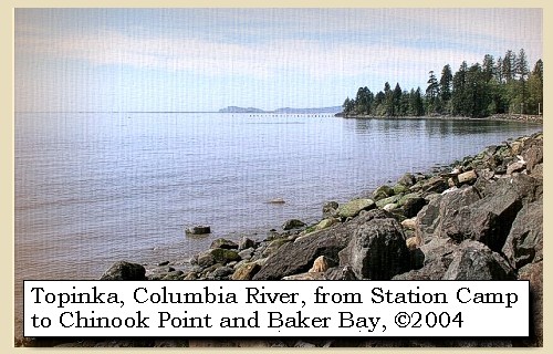
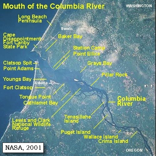
At the Pacific,
Station Camp to Fort Canby

Station Camp, Chinook Point, Chinook River, Wallacut River, Baker Bay, Small Rocky Island, Cape Disappointment, North Head, McKenzie Head, Fort Canby, and the Lewis and Clark Interpretive Center, Tillamook Head, Point Adams, Fort Stevens and Fort Stevens State Park, and Clatsop Spit
CONTINUE

November 19-24
At the Pacific, Station Camp, Fort Canby, Long Beach
 

On October 7, 1805, Lewis and Clark and the "Corps of Discovery" began their journey down the Clearwater River and into the volcanics of the Pacific Northwest. The Corps travelled from the Clearwater to the Snake and down the "Great Columbia", finally reaching the Pacific Ocean on November 15, 1805. Along the journey they encountered the lava flows of the Columbia Plateau, river channels carved by the great "Missoula Floods", and the awesome beauty of five Cascade Range volcanoes.

Map, Lewis and Clark in the Pacific Northwest, click for brief
                         summary
[Click map for brief summary about the area]


To the Pacific - November 1805
At the Pacific - Station Camp to Fort Canby
 

Lewis and Clark's camp between November 15 through November 24, 1805 - "Station Camp" - was located near today's McGowan, Washington, today the site of Lewis & Clark Campsite State Park. Captain Lewis had just returned from the coast, and on November 18, 1805, Captain Clark and 11 men left for their exploration to the coast.

Monday, November 18, 1805
at daylight, accompanied by eleven men. He [Captain Clark] proceeded along the beach one mile to a point of rocks about forty feet high [Chinook Point], where the hills retire, leaving a wide beach, and a number of ponds covered with water-fowl, between which and the mountain is a narrow bottom of alder and small balsam trees.


Along the Journey - November 18, 1805
Chinook Point, 2004

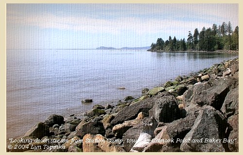
Chinook Point:
Chinook Point is the site of the present Fort Columbia, and is often thought of as Scarborough Head. -- Pacific County Friends of Lewis and Clark Website, 2002


Map, 1887, Mouth of the Columbia River, click to enlarge Map, 1987, Cape Disappointment, Ilwaco, Baker Bay, click to enlarge Map, 1987, McGowan, Point Ellice, , click to enlarge Image, 1997, Chinook Point, click to enlarge Image, 2004, Downstream from Station Camp
  1. 1887 Map (section of original), Mouth of the Columbia River. (Click to enlarge). Original Map: The Columbia River from Celilo to the mouth showing locations of the salmon fisheries, 1887. Scale ca. 1:375,000, Relief shown by hachures. U.S. Army Corps of Engineers, Engineer Office, G.P.O. 1888. University of Washington Archives #UW128. -- University of Washington Library Archives Website, 2002
  2. 1987 Map, Cape Disappointment, Ilwaco, Baker Bay (section of original). (Click to enlarge). Chinook Point is just visible in lower right corner. Office of Coast Surveys, Historical Maps and Charts, Columbia River, Pacific Ocean to Harrington Point, 1987, Chart#18521, 1:40,000. -- NOAA Office of Coast Survey Website, 2004
  3. 1987 Map, Chinook Point, McGowan, Point Ellice (section of original). (Click to enlarge). Office of Coast Surveys, Historical Maps and Charts, Columbia River, Pacific Ocean to Harrington Point, 1987, Chart#18521, 1:40,000. -- NOAA Office of Coast Survey Website, 2004
  4. 1997, Aerial view, Chinook Point. (Click to enlarge). Washington State Department of Ecology Shorelines Aerial Photo #PAC0607, May 13, 1997. -- Washington State Department of Ecology Website, 2002
  5. 2004, From Station Camp, looking downstream. Chinook Point is in the distance, with Baker Bay and Cape Disappointment at skyline. (Click to enlarge). Copyright © 2004 Lyn Topinka, private archives, used with permission.


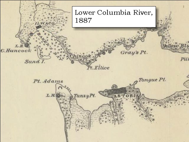
Fort Columbia:
Fort Columbia is one of the few intact coastal defense sites in the United States. Fort Columbia was built from 1896 to 1904 to support the defenses of the Columbia River. The fort was constructed on the Chinook Point promontory because of the unobstructed view. The fort was fully manned and operational through three wars, until it was declared surplus at the end of World War II. In 1950 the area was transferred to the custody of the state of Washington to become Fort Columbia State Park. Twelve historic wood-frame buildings still stand on the premises, and the 593-acre day-use park has 6,400 feet of freshwater shoreline on the Columbia River. -- Washington State Parks and Recreation Website, 2002


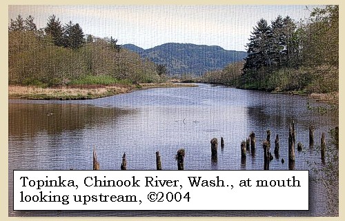
Seven miles from the rocks is the entrance of a creek, or rather drain from the ponds and hills, where is a cabin of Chinnooks. [Chinook River] ......


Along the Journey - November 18, 1805
Chinook River, 2004

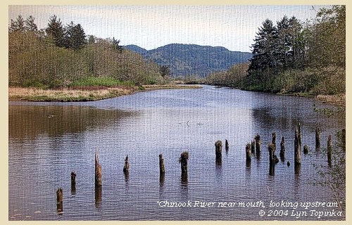
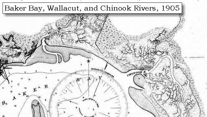
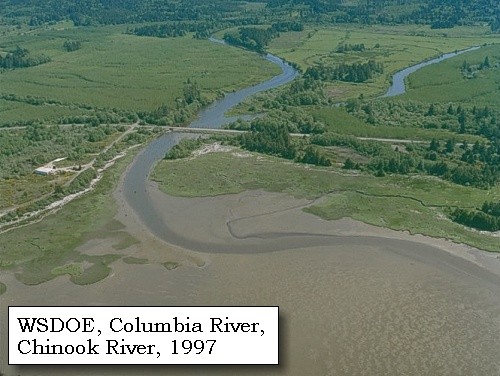
Chinook River:
There is an inconsistency between the maps and journals when trying to determine the names Lewis and Clark applied to two rivers that drained into "Haley's Bay." "White Brant Creek" and "Chinook River" are labeled differently on Clark's maps of the Columbia's mouth. He also misidentified the rivers when he went on a sojourn to the coast with 11 men. He probably intended the "Chinook River" to be applied to the drainage close to the village of that native nation. -- Washington State Historical Society Website, 2002


Map, 1887, Columbia River from mouth to Pillar Rock, click to enlarge Map, 1905, Wallacut and Chinook Rivers, click to enlarge Map, 1987, Cape Disappointment, Ilwaco, Baker Bay, click to enlarge Image, 1997, Chinook River, click to enlarge Image, 2004, Chinook River, Washington
  1. 1887 Map, Columbia River from the Mouth to Pillar Rock (section of original). (Click to enlarge). The mouth of the Chinook River (left of Chinook Point) is depicted but not named. Original Map: The Columbia River from Celilo to the mouth showing locations of the salmon fisheries, 1887. Scale ca. 1:375,000, Relief shown by hachures. U.S. Army Corps of Engineers, Engineer Office, G.P.O. 1888. University of Washington Archives #UW128. -- University of Washington Library Archives Website, 2004
  2. 1905 Map, Wallacut and Chinook Rivers, Washington (section of original). (Click to enlarge). Original Map: "Columbia River, Sheet No.1, Entrance to Upper Astoria". U.S. Coast Survey, 1905, #6140, Scale 1:40,000. U.S. Office of Coast Survey Historical Map and Chart Collection #3853659. -- NOAA Archives Website, 2004
  3. 1987 Map, Cape Disappointment, Ilwaco, Baker Bay (section of original). (Click to enlarge). Office of Coast Surveys, Historical Maps and Charts, Columbia River, Pacific Ocean to Harrington Point, 1987, Chart#18521, 1:40,000. -- NOAA Office of Coast Survey Website, 2004
  4. 1997, Aerial view, Chinook River. (Click to enlarge). Washington State Department of Ecology Shorelines Aerial Photo #PAC0591, May 13, 1997. -- Washington State Department of Ecology Website, 2002
  5. 2004, Chinook River, Washington, looking upstream from near mouth. (Click to enlarge). Copyright © 2004 Lyn Topinka, private archives, used with permission.


We were taken across in a canoe by two squaws, to each of whom we gave a fishhook, and then coasting along the bay, passed at two miles the low bluff of a small hill, below which are the ruins of some old huts, and close to it the remains of a whale. The country is low, open and marshy; interspersed with some high pine and a thick undergrowth. Five miles from the creek, we came to a stream forty yards wide at low water, which we called Chinnook river. [Wallacut River]


Along the Journey - November 18, 1805
Map, Wallacut and Chinook Rivers, 1905

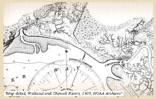
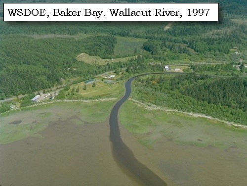
Wallacut River:
Errors created in transferring information from the journals to maps become apparent when studying the names the captains applied to this drainage. "White Brant Creek" was intended to be applied to the most westerly drainage into "Haley's Bay." "Chinook River" is charted for the watershed on one of Clark's maps, and he called the river by the same name when he camped near it while returning from the coast. Conjecture and second-hand information may have confused the captains. This drainage was used by the Chinook Indians to reach their winter village, but Clark intended the drainage near the Indians' summer village to be named after its inhabitants. "Knights River" was used by HBC employees to identify the drainage. The present place name for the river came from the Chinook Indian word, "Walihut," meaning "place of stones." Near the mouth of the river, the north bank has many small, smooth boulders. -- Washington State Historical Society Website, 2002


Map, 1887, Columbia River from mouth to Pillar Rock, click to enlarge Map, 1905, Wallacut and Chinook Rivers, click to enlarge Map, 1987, Cape Disappointment, Ilwaco, Baker Bay, click to enlarge Image, 1997, Wallacut River, click to enlarge
  1. 1887 Map, Columbia River from the Mouth to Pillar Rock (section of original). (Click to enlarge). The Wallacut River (at Ilwaco) is depicted but not named. Original Map: The Columbia River from Celilo to the mouth showing locations of the salmon fisheries, 1887. Scale ca. 1:375,000, Relief shown by hachures. U.S. Army Corps of Engineers, Engineer Office, G.P.O. 1888. University of Washington Archives #UW128. -- University of Washington Library Archives Website, 2004
  2. 1905 Map, Wallacut and Chinook Rivers, Washington (section of original). (Click to enlarge). Original Map: "Columbia River, Sheet No.1, Entrance to Upper Astoria". U.S. Coast Survey, 1905, #6140, Scale 1:40,000. U.S. Office of Coast Survey Historical Map and Chart Collection #3853659. -- NOAA Archives Website, 2004
  3. 1987 Map, Cape Disappointment, Ilwaco, Baker Bay (section of original). (Click to enlarge). Office of Coast Surveys, Historical Maps and Charts, Columbia River, Pacific Ocean to Harrington Point, 1987, Chart#18521, 1:40,000. -- NOAA Office of Coast Survey Website, 2004
  4. 1997, Aerial view, Wallacut River. (Click to enlarge). Washington State Department of Ecology Shorelines Aerial Photo #PAC0581, May 13, 1997. -- Washington State Department of Ecology Website, 2002


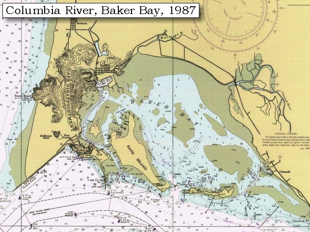
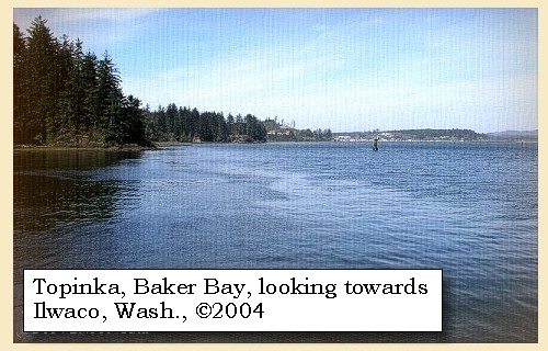
The hills up this river [Wallacut River] and towards the bay [Baker Bay] are not high, but very thickly covered with large pine of several species: in many places pine trees, three or four feet in thickness, are seen growing on the bodies of large trees, which though fallen and covered with moss, were in part sound. Here we dined on some brant and plover, killed as we came along, and after crossing in a boat lying in the sand near some old houses, proceeded along a bluff of yellow clay and soft stone to a little bay or harbour, into which a drain from some ponds empties [location of today's Ilwaco, Washington]: at this harbour the land is low, but as we went on it rose to hills of eighty or ninety feet above the water.


Along the Journey - November 18, 1805
Baker Bay with Ilwaco, Washington in the distance, 2004

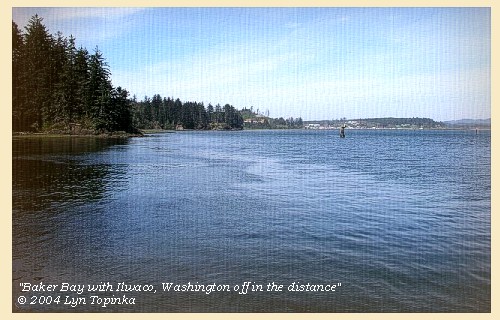
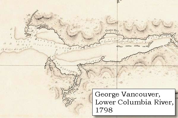
Baker Bay:
In 1792, William Broughton named the bay, "Baker's Bay," to give credit to a British merchant, Captain James Baker, whose ship was anchored inside the Columbia's mouth when Broughton crossed the bar to explore the river for Vancouver. Lewis and Clark named the bay "Haley's Bay", for the Indians' favorite trader, as reported to the captains. -- Washington State Historical Society Website, 2002


Map, 1814, Lewis and Clark on the Columbia, click to enlarge Map, 1887, Mouth of the Columbia River, click to enlarge Map, 1887, Cape Disappointment and Baker Bay, click to enlarge Map, 1987, Cape Disappointment, Ilwaco, Baker Bay, click to enlarge NASA Image, 2001, Mouth of the Columbia River, click to enlarge Image, 2004, Downstream from Station Camp Image, 2004, Baker Bay and Ilwaco, Washington
  1. 1814 Map, Lewis and Clark's map of the Columbia River (section of original). (Click to enlarge.) Baker Bay is just barely depicted on the map, and has no clear definition (just east of Cape Disappointment). Map also includes three of the five volcanoes Lewis and Clark saw and commented on. While the journals mention the expedition seeing Mount Adams, it does not appear on their map. Mount Jefferson is to the south (bottom) and off the map. From the "Nicholas Biddle/Paul Allen" 1814 publication. Original Map: "A Map of Lewis and Clark's Track, Across the Western Portion of North America, From the Mississippi to the Pacific Ocean". From: History of the expedition under the command of Captains Lewis and Clark : to the sources of the Missouri, thence across the Rocky Mountains and down the river Columbia to the Pacific Ocean : performed during the years 1804-5-6 : by order of the government of the United States / prepared for the press by Paul Allen. Philadelphia : Bradford and Insskeep, 1814. Harold B. Lee Library, Brigham Young University #upbover maps37. -- Brigham Young University, Harold B. Lee Library Website, 2004.
  2. 1887 Map (section of original), Mouth of the Columbia River. (Click to enlarge). Original Map: The Columbia River from Celilo to the mouth showing locations of the salmon fisheries, 1887. Scale ca. 1:375,000, Relief shown by hachures. U.S. Army Corps of Engineers, Engineer Office, G.P.O. 1888. University of Washington Archives #UW128. -- University of Washington Library Archives Website, 2002
  3. 1887, Map, Cape Disappointment and Baker Bay. (Click to enlarge). Mouth of the Columbia River showing fishtraps in Baker's Bay, 1887. U.S. Army Corps of Engineers Map, published 1888. University of Washington Map Archives #UW129. -- University of Washington Library Collections Website, 2002
  4. 1987 Map, Cape Disappointment, Ilwaco, Baker Bay (section of original). (Click to enlarge). Office of Coast Surveys, Historical Maps and Charts, Columbia River, Pacific Ocean to Harrington Point, 1987, Chart#18521, 1:40,000. -- NOAA Office of Coast Survey Website, 2004
  5. 2001, NASA Image, Mouth of the Columbia River, including Baker Bay. (Click to enlarge). NASA Space Shuttle photograph of the mouth of the Columbia River, including the location of Fort Clatsop, Lewis and Clark National Wildlife Refuge, Tenasillahe Island, Puget Island, and Crim's Island, and others, June 20, 2001. NASA Astronaut Photography of Earth #SS002-724-30. -- NASA Astronaut Photography of Earth Website, 2002
  6. 2004, From Station Camp, looking downstream. Chinook Point is in the distance, with Baker Bay and Cape Disappointment at skyline. (Click to enlarge). Copyright © 2004 Lyn Topinka, private archives, used with permission.
  7. 2004, Looking across western end of Baker Bay towards Ilwaco, Washington. (Click to enlarge). Image taken from Cape Disappointment. Copyright © 2004 Lyn Topinka, private archives, used with permission.


At the distance of one mile is a second bay, and a mile beyond it, a small rocky island in a deep bend, which seems to afford a very good harbour, and where the natives inform us European vessels anchor for the purpose of trading.


Along the Journey - November 18, 1805
Small Rocky Island, 1997

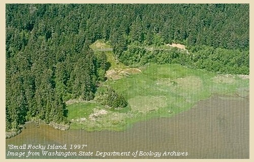
Small Rocky Island:
Although the island is still there, the anchorage is silt in and covered with grass and the 'island' is no longer actually so. -- Pacific County Friends of Lewis & Clark Website, 2002


Image, 1997, Small Rocky Island, click to enlarge
  1. 1997, Aerial view, "small rocky island". (Click to enlarge). Washington State Department of Ecology Shorelines Aerial Photo #PAC0572, May 13, 1997. -- Washington State Department of Ecology Website, 2002


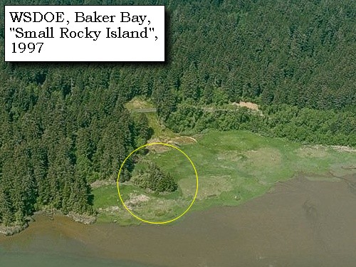
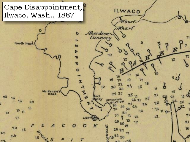
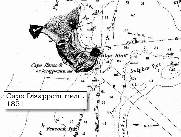
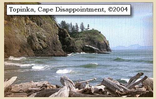
We went on round another bay, in which is a second small island of rocks, and crossed a small stream [???], which rises in a pond near the sea coast [O'Neil Lake], and after running through a low isthmus empties into the bay. [today this area is Fort Canby State Park] This narrow low ground, about two or three hundred yards wide, separates from the main hills a kind of peninsula [Cape Disappointment], the extremity of which is two miles from the anchoring place; and this spot, which was called cape Disappointment, is an elevated, circular knob [McKenzie Head], rising with a steep ascent one hundred and fifty or one hundred and sixty feet above the water, formed like the whole shore of the bay, as well as of the seacoast, and covered with thick timber on the inner side, but open and grassy in the exposure next the sea.


Along the Journey - November 18, 1805
Cape Disappointment, 2004

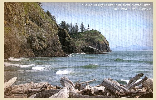
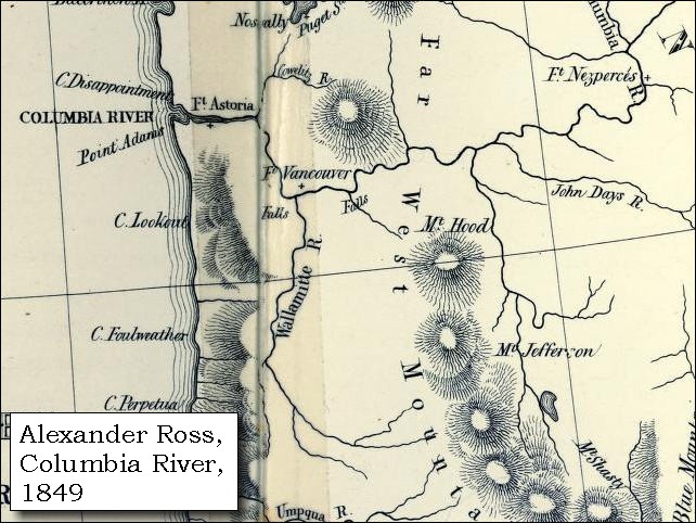
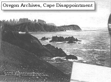
Cape Disappointment:
Cape Disappointment, the rugged north point at the Columbia River entrance, is the first major headland along the 20 miles of sand beach north from Tillamook Head. It comprises a group of rounding hills covering an area 2.5 miles long and one mile wide, divided by a narrow valley extending north-northwest. The seaward faces of these hills are precipitous cliffs with jagged, rocky points and small strips of sand beach. Lewis and Clark used the British geographical place names given by Captain John Meares, a British trading merchant, to describe the headlands at the mouth of the Columbia. In 1788 Meares was disappointed at not finding "The River of the West". When he saw the mouth of the Columbia River, he thought it was only an entrance to a bay -- thus the name Cape Disappointment. Cape Disappointment is one of the oldest British geographical place names in Washington. -- NOAA Office of Coast Survey Website, 2003, and Washington State Historical Society Website, 2002


Map, 1787, Coastline around Columbia River, click to enlarge Map, 1798, Mouth of the Columbia River, click to enlarge Map, 1814, Lewis and Clark on the Columbia, click to enlarge Map, 1849, Alexander Ross's Columbia River, click to enlarge Map, 1851, Cape Disappointment (Cape Hancock), click to enlarge Map, 1853, Washington and Oregon and the Columbia River, click to enlarge Map, 1855, Mouth of the Columbia River, click to enlarge Map, 1855, Northwest Oregon and mouth Columbia River, click to enlarge Map, 1887, Columbia River from mouth to Pillar Rock, click to enlarge Map, 1887, Cape Disappointment and Baker Bay, click to enlarge Map, 1949, Cape Disappointment, North Head, McKenzie Head, Ilwaco, click to enlarge Map, 1987, Cape Disappointment, Ilwaco, Baker Bay, click to enlarge NASA Image, 2001, Mouth of the Columbia River, click to enlarge Image, ca.1879-1909, Cape Disappointment, click to enlarge Image, 1997, Cape Disappointment, click to enlarge Image, 2004, Cape Disappointment
  1. 1787 Map, North American Coastline around the Columbia River (section of original). (Click to enlarge). Includes Cape Disappointment as "C. de San Roque". Original Map: "Carta que contiene parte de la costa de la California", by Bernabe Munoz, 1787. Scale ca.1:5,000,000. Library of Congress American Memory Archives #G4362.C6 1787 .M8 TIL Vault. -- U.S. Library of Congress Archives, 2004, "American Memory"
  2. 1798 Map, Mouth of the Columbia River (section of original). (Click to enlarge). Inset map of original, showing the mouth of the Columbia River, including Cape Disappointment, Point Adams, Youngs River, Point George (today's Astoria), and Grays Bay. Original Map: George Vancouver's "A Chart Shewing Part of the Coast of N.W. America." In A Voyage of discovery to the North Pacific ocean, and Round the World. London, 1798. University of Virginia Special Collection "Lewis & Clark, The Maps of Exploration 1507-1814". -- University of Virginia Library Archives Website, 2004
  3. 1814 Map, Lewis and Clark's map of the Columbia River (section of original). (Click to enlarge.) Shows Cape Disappointment. Map also includes three of the five volcanoes Lewis and Clark saw and commented on. While the journals mention the expedition seeing Mount Adams, it does not appear on their map. Mount Jefferson is to the south (bottom) and off the map. From the "Nicholas Biddle/Paul Allen" 1814 publication. Original Map: "A Map of Lewis and Clark's Track, Across the Western Portion of North America, From the Mississippi to the Pacific Ocean". From: History of the expedition under the command of Captains Lewis and Clark : to the sources of the Missouri, thence across the Rocky Mountains and down the river Columbia to the Pacific Ocean : performed during the years 1804-5-6 : by order of the government of the United States / prepared for the press by Paul Allen. Philadelphia : Bradford and Insskeep, 1814. Harold B. Lee Library, Brigham Young University #upbover maps37. -- Brigham Young University, Harold B. Lee Library Website, 2004.
  4. 1849 Map (section of original), Alexander Ross's Columbia River. (Click to enlarge). Original Map: Map of the Columbia to illustrate Ross's adventures. Author: Alexander Ross; Publication Date: 1849; Publisher: London, Smith, Elder and Co., 1849. Washington State University Archives #WSU478. -- Washington State University Early Washington Maps Digital Collection Website, 2004
  5. 1851 Map, Cape Disappointment, Washington (section of original). (Click to enlarge). Cape Disappointment was also known as Cape Hancock. Original Map: "Mouth of the Columbia River, Preliminary Survey, 1851". U.S. Coast Survey, 1851, #640, Scale 1:40,000. U.S. Office of Coast Survey Historical Map and Chart Collection #2228148. -- NOAA Archives Website, 2004
  6. 1853 Map, Washington and Oregon and the Columbia River, from the Clearwater River to the Snake River and down the Columbia River to the Pacific Ocean (section of original). (Click to enlarge). Includes: Clearwater River (Kooskooski), Lapwai Creek (Lapwai R.), Snake River (Saptin or Lewis R.), Columbia River (Columbia R.), Yakima River (Yakima R.), Walla Walla River (Wallawalla R.), Umatilla River (Umatilla R.), Willow Creek (Quesnells R.), John Day River (John day's R.), Deschutes River (Fall R.), Willamette River (Willammette R.), and Cowlitz River (Cowlitz R.). Original Map: "Map of California, Oregon, Washington, Utah, and New Mexico (1853)", by Thomas Cowperthwait & Co. Washington State University Archives #WSU22. -- Washington State University Library Collections Website, 2003
  7. 1855 Map, Mouth of the Columbia River, with Cape Disappointment and Long Beach Peninsula (section of original). (Click to enlarge). Original Map: "Map of a part of the Territory of Washington : to accompany report of Surveyor General (1855)". By James Tilton, Washington (State) Surveyor General's Office. Relief shown by hachures, Scale 1:1,140,480. Washington State University Historical Maps Collection #WSU314, and University of Washington Map Collection #UW114. -- Washington State University Library Archives Website, 2004
  8. 1855 Map, Northwest Oregon and mouth of the Columbia River (section of original). (Click to enlarge). Includes the Columbia River, Cape Disappointment, Point Adams, Saddle Mountain, Lewis and Clark River, Youngs River. Original Map: From the northern boundary of California to the Columbia River : from explorations and surveys / made under the direction of Hon. Jefferson Davis, Sec. of War by Lieut. R. S. Williamson, U.S. Topl. Engrs. and Lieut. H. L. Abbot, U.S. Topl. Engrs., H. C. Fillebrown, J. Young, and C. D. Anderson, Assts., 1855. Notes: Scale 1:760,320. Relief shown by hachures. At head of title: Routes in Oregon and California. Map no. 2. "Drawn by John Young." From U.S. War Department, Explorations and Surveys for a Railroad Route from the Mississippi River to the Pacific Ocean. Topographical Maps... to Illustrate the Various Reports... (Washington, 1859) Library of Congress American Memory Archives #G4290 1855 .W5 RR 170. -- U.S. Library of Congress Archives, 2004, "American Memory"
  9. 1887 Map, Columbia River from the Mouth to Pillar Rock (section of original). (Click to enlarge). Cape Disappointment is shown as Cape Hancock. Original Map: The Columbia River from Celilo to the mouth showing locations of the salmon fisheries, 1887. Scale ca. 1:375,000, Relief shown by hachures. U.S. Army Corps of Engineers, Engineer Office, G.P.O. 1888. University of Washington Archives #UW128. -- University of Washington Library Archives Website, 2004
  10. 1887, Map, Cape Disappointment and Baker Bay. (Click to enlarge). Mouth of the Columbia River showing fishtraps in Baker's Bay, 1887. U.S. Army Corps of Engineers Map, published 1888. University of Washington Map Archives #UW129. -- University of Washington Library Collections Website, 2002
  11. 1949 Map (section of original), Cape Disappointment, North Head, McKenzie Head, Fort Canby, Ilwaco. (Click to enlarge). Office of Coast Surveys, Historical Maps and Charts, Columbia River, Pacific Ocean to Harrington Point, 1949, Chart#6151, 1:40,000. -- NOAA Office of Coast Survey Website, 2004
  12. 1987 Map, Cape Disappointment, Ilwaco, Baker Bay (section of original). (Click to enlarge). Office of Coast Surveys, Historical Maps and Charts, Columbia River, Pacific Ocean to Harrington Point, 1987, Chart#18521, 1:40,000. -- NOAA Office of Coast Survey Website, 2004
  13. 2001, NASA Image, Mouth of the Columbia River, including Cape Disappointment. (Click to enlarge). NASA Space Shuttle photograph of the mouth of the Columbia River, including the location of Fort Clatsop, Lewis and Clark National Wildlife Refuge, Tenasillahe Island, Puget Island, and Crim's Island, and others, June 20, 2001. NASA Astronaut Photography of Earth #SS002-724-30. -- NASA Astronaut Photography of Earth Website, 2002
  14. ca.1879-1909, Cape Disappointment. (Click to enlarge). Pictured is a scene in the region served by the Oregon Railway & Navigation Company between 1879-1909. This is Cape Disappointment, north of the Columbia River. Photographer unknown. Oregon State Archives Salem Public Library #ORN25A. -- Oregon State Archives Website, 2003
  15. 1997, Aerial view, Cape Disappointment. (Click to enlarge). Looking at Cape Disappointment Lighthouse. Washington State Department of Ecology Shorelines Aerial Photo #PAC0547, May 10, 1997. -- Washington State Department of Ecology Website, 2002
  16. 2004, Cape Disappointment, as seen from North Spit, looking towards Cape Disappointment Lighthouse. (Click to enlarge). Copyright © 2004 Lyn Topinka, private archives, used with permission.


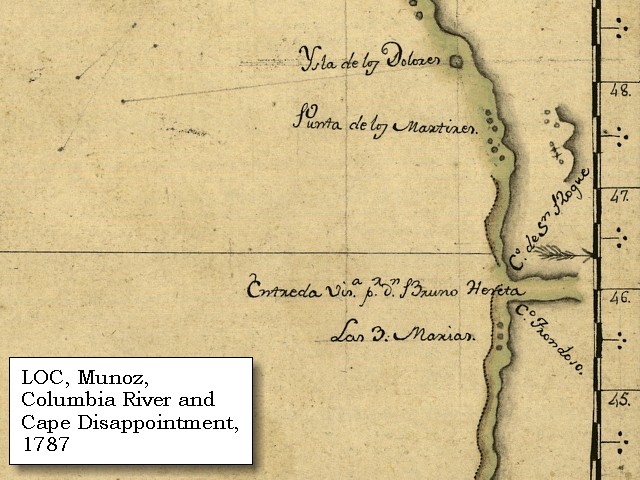
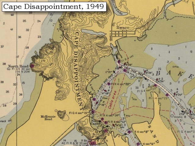
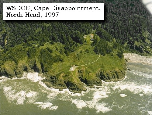
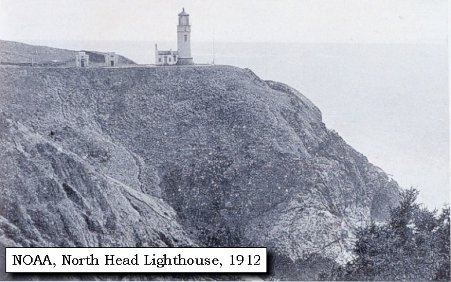
North Head:
North Head, the extreme western point of Cape Disappointment, is 170 feet high, with a very jagged, precipitous cliff, backed by a narrow grassy strip. The higher ground behind it is covered with trees. The North Head Lighthouse was built in 1898, and affords a spectacular view of the Pacific Ocean, with Benson Beach and the mouth of the Columbia River to the south and the Long Beach Peninsula stretching northward, a panoramic vista unparalleled on a clear day. -- NOAA Office of Coastal Survey website, 2003, Washington State Parks and Recreation Website, 2003, and Long Beach Area State Parks, 2002


Map, 1887, Cape Disappointment and Baker Bay, click to enlarge Map, 1949, Cape Disappointment, North Head, McKenzie Head, Ilwaco, click to enlarge Image, 1997, North Head, click to enlarge Image, 1912, North Head Lighthouse, click to enlarge
  1. 1887, Map, Cape Disappointment and Baker Bay, including McKenzie Head. (Click to enlarge). Mouth of the Columbia River showing fishtraps in Baker's Bay, 1887. U.S. Army Corps of Engineers Map, published 1888. University of Washington Map Archives #UW129. -- University of Washington Library Collections Website, 2002
  2. 1949 Map (section of original), Cape Disappointment, North Head, McKenzie Head, Fort Canby, Ilwaco. (Click to enlarge). Office of Coast Surveys, Historical Maps and Charts, Columbia River, Pacific Ocean to Harrington Point, 1949, Chart#6151, 1:40,000. -- NOAA Office of Coast Survey Website, 2004
  3. 1997, Aerial view, North Head showing the North Head Lighthouse. (Click to enlarge). Washington State Department of Ecology Shorelines Aerial Photo #PAC0533, May 10, 1997. -- Washington State Department of Ecology Website, 2002
  4. 1912, North Head Lighthouse. (Click to enlarge). Original from: "Puget Sound and Western Washington Cities-Towns Scenery" by Robert A. Reid, Robert A. Reid Publisher, Seattle, 1912. Archival photograph by Steve Nicklas, NGS/RSD. Image from the NOAA Photo Archives Coastline Collection #line2186. -- NOAA Photo Archives Website, 2002


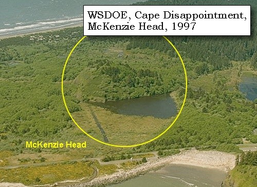
McKenzie Head:
McKenzie Head is located 0.8 miles northwest of Cape Disappointment Light. It is 190 feet high and nearly round. On its seaward face it is covered with grass and fern, bare of trees. On its eastern face it is heavily wooded with spruce. -- NOAA Office of Coast Survey Website, 2003


Map, 1887, Cape Disappointment and Baker Bay, click to enlarge Map, 1949, Cape Disappointment, North Head, McKenzie Head, Ilwaco, click to enlarge Image, 1997, McKenzie Head, click to enlarge
  1. 1887, Map, Cape Disappointment and Baker Bay, including McKenzie Head. (Click to enlarge). Mouth of the Columbia River showing fishtraps in Baker's Bay, 1887. U.S. Army Corps of Engineers Map, published 1888. University of Washington Map Archives #UW129. -- University of Washington Library Collections Website, 2002
  2. 1949 Map (section of original), Cape Disappointment, North Head, McKenzie Head, Fort Canby, Ilwaco. (Click to enlarge). Office of Coast Surveys, Historical Maps and Charts, Columbia River, Pacific Ocean to Harrington Point, 1949, Chart#6151, 1:40,000. -- NOAA Office of Coast Survey Website, 2004
  3. 1997, Aerial view, McKenzie Head. (Click to enlarge). Washington State Department of Ecology Shorelines Aerial Photo #PAC0544, May 10, 1997. -- Washington State Department of Ecology Website, 2002


Fort Canby:
In 1862, Cape Disappointment was armed with smoothbore cannons to protect the mouth of the Columbia River from enemies. The installation was expanded to become Fort Canby in 1875. The fort was named after General Edward Canby, who was killed in the Modoc Indian War. The fort continued to be improved until the end of World War II. Gun batteries still sit uptop the park. Today Cape Disappointment State Park (formerly Fort Canby State Park) is a 1,882-acre camping park which offers 27 miles of ocean beach, two lighthouses, an interpretive center and hiking trails. Visitors enjoy beachcombing and exploring the area's rich natural and cultural history. The nearby coastal towns of Ilwaco and Long Beach feature special events and festivals spring through fall. -- Washington State Parks and Recreation Website, 2002


Map, 1949, Cape Disappointment, North Head, McKenzie Head, Ilwaco, click to enlarge NASA Image, 2001, Mouth of the Columbia River, click to enlarge Image, 1997, Fort Canby State Park, click to enlarge
  1. 1949 Map (section of original), Cape Disappointment, North Head, McKenzie Head, Fort Canby, Ilwaco. (Click to enlarge). Office of Coast Surveys, Historical Maps and Charts, Columbia River, Pacific Ocean to Harrington Point, 1949, Chart#6151, 1:40,000. -- NOAA Office of Coast Survey Website, 2004
  2. 2001, NASA Image, Mouth of the Columbia River, including Fort Canby State Park. (Click to enlarge). NASA Space Shuttle photograph of the mouth of the Columbia River, including the location of Fort Clatsop, Lewis and Clark National Wildlife Refuge, Tenasillahe Island, Puget Island, and Crim's Island, and others, June 20, 2001. NASA Astronaut Photography of Earth #SS002-724-30. -- NASA Astronaut Photography of Earth Website, 2002
  3. 1997, Aerial view, Fort Canby State Park. (Click to enlarge). Washington State Department of Ecology Shorelines Aerial Photo #PAC0546, May 10, 1997. -- Washington State Department of Ecology Website, 2002


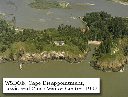
Lewis and Clark Interpretive Center:
In November of 1805, the U.S. Corps of Volunteers for Northwest Discovery, led by Meriwether Lewis and William Clark, reached the mouth of the mighty Columbia River and the Pacific Ocean at last. "Great joy in camp," Clark wrote in his journal, "we are in View of the Ocian, this great Pacific Ocian which we been So long anxious to See." Today the Lewis and Clark Interpretive Center stands high on the cliffs of Fort Canby State Park, 200 feet above the pounding Pacific surf. A series of mural-sized "timeline" panels guide visitors through the westward journey of the Lewis and Clark Expedition using sketches, paintings, photographs and the words of Corps members themselves. The center also features short film presentations, a gift shop and a glassed-in observation deck with fabulous views of the river, headlands and sea. -- Washington State Parks and Recreation Website, 2003


Image, 1997, Fort Canby State Park, click to enlarge
  1. 1997, Aerial view, Fort Canby State Park and the Lewis and Clark Interpretive Center. (Click to enlarge). Washington State Department of Ecology Shorelines Aerial Photo #PAC0546, May 10, 1997. -- Washington State Department of Ecology Website, 2002


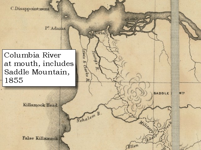
From this cape a high point of land bears south 20o west [Tillamook Head], about twenty-five miles distant.


Along the Journey - November 18, 1805
Tillamook Head, 1951

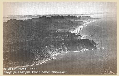
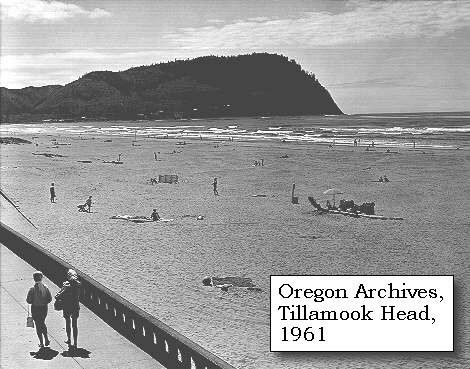
Tillamook Head:
Lewis named the large promontory that projects into the ocean "Clark's Point of View", after Clark, who first saw the "high point of a Mountn" from Cape Disappointment. Later, Clark climbed the mountain when he took a contingent of the corps to view a beached whale south of the headlands. While on Tillamook Head he hiked out on a point (Bird Point) and described the view; hence the name "Clark's Point of View" was first applied to the mountain. The present name is derived from the Tillamook Indians who lived along the coast on both sides of the headland. The name is from the Chinook language but has been anglicized for modern convenience. Once spelled "Killamuck," the spelling was changed to Tillamook about the time Tillamook County was created by Oregon's territorial legislature in 1853. -- Washington State Historical Society Website, 2002


Map, 1814, Lewis and Clark on the Columbia, click to enlarge Map, 1853, Washington and Oregon and the Columbia River, click to enlarge Map, 1855, Northwest Oregon and mouth Columbia River, click to enlarge NASA Image, 2001, Mouth of the Columbia River, click to enlarge Image, 1951, Aerial of Tillamook Head, click to enlarge Image, 1961, Tillamook Head, click to enlarge
  1. 1814 Map, Lewis and Clark's map of the Columbia River (section of original). (Click to enlarge.) Shows Tillamook Head as "Clarks Pt of View". Map includes three of the five volcanoes Lewis and Clark saw and commented on. While the journals mention the expedition seeing Mount Adams, it does not appear on their map. Mount Jefferson is to the south (bottom) and off the map. From the "Nicholas Biddle/Paul Allen" 1814 publication. Original Map: "A Map of Lewis and Clark's Track, Across the Western Portion of North America, From the Mississippi to the Pacific Ocean". From: History of the expedition under the command of Captains Lewis and Clark : to the sources of the Missouri, thence across the Rocky Mountains and down the river Columbia to the Pacific Ocean : performed during the years 1804-5-6 : by order of the government of the United States / prepared for the press by Paul Allen. Philadelphia : Bradford and Insskeep, 1814. Harold B. Lee Library, Brigham Young University #upbover maps37. -- Brigham Young University, Harold B. Lee Library Website, 2004.
  2. 1853 Map, Washington and Oregon and the Columbia River, from the Clearwater River to the Snake River and down the Columbia River to the Pacific Ocean (section of original). (Click to enlarge). Includes: Clearwater River (Kooskooski), Lapwai Creek (Lapwai R.), Snake River (Saptin or Lewis R.), Columbia River (Columbia R.), Yakima River (Yakima R.), Walla Walla River (Wallawalla R.), Umatilla River (Umatilla R.), Willow Creek (Quesnells R.), John Day River (John day's R.), Deschutes River (Fall R.), Willamette River (Willammette R.), and Cowlitz River (Cowlitz R.). Original Map: "Map of California, Oregon, Washington, Utah, and New Mexico (1853)", by Thomas Cowperthwait & Co. Washington State University Archives #WSU22. -- Washington State University Library Collections Website, 2003
  3. 1855 Map, Northwest Oregon and mouth of the Columbia River (section of original). (Click to enlarge). Includes the Columbia River, Cape Disappointment, Point Adams, Saddle Mountain, Lewis and Clark River, Youngs River. Original Map: From the northern boundary of California to the Columbia River : from explorations and surveys / made under the direction of Hon. Jefferson Davis, Sec. of War by Lieut. R. S. Williamson, U.S. Topl. Engrs. and Lieut. H. L. Abbot, U.S. Topl. Engrs., H. C. Fillebrown, J. Young, and C. D. Anderson, Assts., 1855. Notes: Scale 1:760,320. Relief shown by hachures. At head of title: Routes in Oregon and California. Map no. 2. "Drawn by John Young." From U.S. War Department, Explorations and Surveys for a Railroad Route from the Mississippi River to the Pacific Ocean. Topographical Maps... to Illustrate the Various Reports... (Washington, 1859) Library of Congress American Memory Archives #G4290 1855 .W5 RR 170. -- U.S. Library of Congress Archives, 2004, "American Memory"
  4. 2001, NASA Image, Mouth of the Columbia River, including Tillamook Head. (Click to enlarge). NASA Space Shuttle photograph of the mouth of the Columbia River, including the location of Fort Clatsop, Lewis and Clark National Wildlife Refuge, Tenasillahe Island, Puget Island, and Crim's Island, and others, June 20, 2001. NASA Astronaut Photography of Earth #SS002-724-30. -- NASA Astronaut Photography of Earth Website, 2002
  5. 1951, Aerial view Tillamook Head. (Click to enlarge). This aerial photo offers a view of the Oregon coastline, looking southward, with Tillamook Head prominent in the foreground, with Cannon Beach, Arch Cape, and Cape Falcon in the distance. Oregon State Archives, Oregon State Highway Division, #OHD5049, December 7, 1951. -- Oregon State Library Archives Website, 2002
  6. 1961, Tillamook Head. (Click to enlarge). Taken at Seaside, Clatsop County, looking to the southwest from the promenade that parallels the wide sandy beach. Oregon State Archives, Oregon State Highway Division, #OHD6871, July 1961. -- Oregon State Library Archives Website, 2002


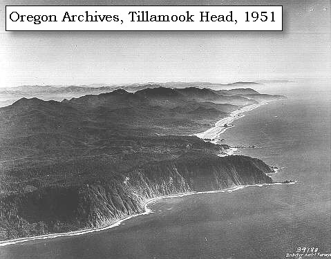
Geology of Tillamook Head:
The spectacular promontories, capes and sea stacks along the northern Oregon coast are composed of basalt, which is more resistant to erosion than the intervening areas of softer sedimentary rocks. Several years ago, geochemical analyses of the elements in the coastal lavas by the U.S. Geological Survey showed that they were identical in composition to the Yakima Basalt (part of the Columbia River Basalt group) of Eastern Oregon and Washington. The Yakima Basalt formed as tremendous outpourings of lava, mostly occurring between 13 million and 17 million years ago, spread out from a series of vertical fissures in easternmost Oregon and Washington and in Idaho. The lava covered nearly 75,000 square miles of these states to depths of several thousands of feet. Many of these flows found their way down a broad ancestral Columbia River valley, which came through the Cascade Range many miles south of the present gorge, and spread out in the area of the present Willamette Valley between Salem and Portland. The oldest lavas filled the ancestral channel of the Columbia River valley directly westward to the sea, since at that time the Coast Range consisted of only a few hills, now seen in the core of the range. The lavas spread out over the coastal plain, and out onto the continental shelf. When each valley filled to overflowing with lava, a new valley formed at the northern edge of the lava field, thus moving the ancestral Columbia River northward after each outpouring of lava. The lava was thickest in the main channel of the river, which eventually became a headland. The individual flows in some of the headlands are so thick (several hundreds of feet) that they must have ponded and formed deep pools of lava in bays or estuaries. -- Allen, 1985, Time Travel in Oregon


In the range between these two eminences, is the opposite point of the bay, a very low ground, which has been variously called cape Rond by Lapeyrouse, and point Adams by Vancouver [Point Adams].


Along the Journey - November 18, 1805
Map, mouth of the Columbia River, 1855

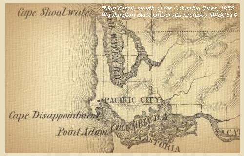
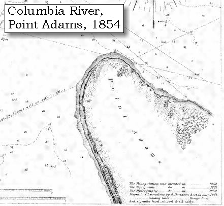
Point Adams:
Point Adams, just inside Clatsop Spit, is a low sandy point covered with spruce and undergrowth to the edge of the sand beach and low dunes. The point usually shows well from seaward, particularly if it is hazy inside. Lewis and Clark used Robert Gray's name for this low, sandy southern peninsula at the mouth of the Columbia River. "Point Adams" and "Columbia River" are names given by Gray which have continued in use to the present time. In 1792 Gray named the north cape on the mouth of the river "Cape Hancock" and the southern peninsula after John Adams, in an attempt to identify his "Columbia's River" with the United States. The Spanish had charted and named the peninsula "Cape Frondosa" (leafy cape), for its numerous trees. In 1890, a lifeboat station at Point Adams was established. -- NOAA Office of Coast Survey Website, 2003, Washington State Historical Society Website, 2002, and Clatsop Historical Society Website, 2004


Map, 1798, Mouth of the Columbia River, click to enlarge Map, 1849, Alexander Ross's Columbia River, click to enlarge Map, 1851, Point Adams and Clatsop Spit, click to enlarge Map, 1853, Washington and Oregon and the Columbia River, click to enlarge Map, 1854, Point Adams, click to enlarge Map, 1855, Mouth of the Columbia River, click to enlarge Map, 1855, Northwest Oregon and mouth Columbia River, click to enlarge Map, 1887, Columbia River from mouth to Pillar Rock, click to enlarge Map, 1905, Point Adams and Clatsop Spit, click to enlarge NASA Image, 2001, Mouth of the Columbia River, click to enlarge Image, 1889, Mount St. Helens and the mouth of the Columbia River, click to enlarge
  1. 1798 Map, Mouth of the Columbia River (section of original). (Click to enlarge). Inset map of original, showing the mouth of the Columbia River, including Cape Disappointment, Point Adams, Youngs River, Point George (today's Astoria), and Grays Bay. Original Map: George Vancouver's "A Chart Shewing Part of the Coast of N.W. America." In A Voyage of discovery to the North Pacific ocean, and Round the World. London, 1798. University of Virginia Special Collection "Lewis & Clark, The Maps of Exploration 1507-1814". -- University of Virginia Library Archives Website, 2004
  2. 1849 Map (section of original), Alexander Ross's Columbia River. (Click to enlarge). Original Map: Map of the Columbia to illustrate Ross's adventures. Author: Alexander Ross; Publication Date: 1849; Publisher: London, Smith, Elder and Co., 1849. Washington State University Archives #WSU478. -- Washington State University Early Washington Maps Digital Collection Website, 2004
  3. 1851 Map, Point Adams and Clatsop Spit, Oregon (section of original). (Click to enlarge). Compare to the 1854 map and 1905 map. Original Map: "Mouth of the Columbia River, Preliminary Survey, 1851". U.S. Coast Survey, 1851, #640, Scale 1:40,000. U.S. Office of Coast Survey Historical Map and Chart Collection #2228148. -- NOAA Archives Website, 2004
  4. 1853 Map, Washington and Oregon and the Columbia River, from the Clearwater River to the Snake River and down the Columbia River to the Pacific Ocean (section of original). (Click to enlarge). Includes: Clearwater River (Kooskooski), Lapwai Creek (Lapwai R.), Snake River (Saptin or Lewis R.), Columbia River (Columbia R.), Yakima River (Yakima R.), Walla Walla River (Wallawalla R.), Umatilla River (Umatilla R.), Willow Creek (Quesnells R.), John Day River (John day's R.), Deschutes River (Fall R.), Willamette River (Willammette R.), and Cowlitz River (Cowlitz R.). Original Map: "Map of California, Oregon, Washington, Utah, and New Mexico (1853)", by Thomas Cowperthwait & Co. Washington State University Archives #WSU22. -- Washington State University Library Collections Website, 2003
  5. 1854 Map, Point Adams, Oregon (section of original). (Click to enlarge). Original Map: "Entrance to Columbia River, Oregon". U.S. Coast Survey, 1854, Plate Number 416, U.S. Office of Coast Survey Historical Map and Chart Collection #928909. -- NOAA Archives Website, 2004
  6. 1855 Map, Mouth of the Columbia River, with Cape Disappointment and Long Beach Peninsula (section of original). (Click to enlarge). Original Map: "Map of a part of the Territory of Washington : to accompany report of Surveyor General (1855)". By James Tilton, Washington (State) Surveyor General's Office. Relief shown by hachures, Scale 1:1,140,480. Washington State University Historical Maps Collection #WSU314, and University of Washington Map Collection #UW114. -- Washington State University Library Archives Website, 2004
  7. 1855 Map, Northwest Oregon and mouth of the Columbia River (section of original). (Click to enlarge). Includes the Columbia River, Cape Disappointment, Point Adams, Saddle Mountain, Lewis and Clark River, Youngs River. Original Map: From the northern boundary of California to the Columbia River : from explorations and surveys / made under the direction of Hon. Jefferson Davis, Sec. of War by Lieut. R. S. Williamson, U.S. Topl. Engrs. and Lieut. H. L. Abbot, U.S. Topl. Engrs., H. C. Fillebrown, J. Young, and C. D. Anderson, Assts., 1855. Notes: Scale 1:760,320. Relief shown by hachures. At head of title: Routes in Oregon and California. Map no. 2. "Drawn by John Young." From U.S. War Department, Explorations and Surveys for a Railroad Route from the Mississippi River to the Pacific Ocean. Topographical Maps... to Illustrate the Various Reports... (Washington, 1859) Library of Congress American Memory Archives #G4290 1855 .W5 RR 170. -- U.S. Library of Congress Archives, 2004, "American Memory"
  8. 1887 Map, Columbia River from the Mouth to Pillar Rock (section of original). (Click to enlarge). Shows Point Adams. Original Map: The Columbia River from Celilo to the mouth showing locations of the salmon fisheries, 1887. Scale ca. 1:375,000, Relief shown by hachures. U.S. Army Corps of Engineers, Engineer Office, G.P.O. 1888. University of Washington Archives #UW128. -- University of Washington Library Archives Website, 2004
  9. 1905 Map, Point Adams and Clatsop Spit, Oregon (section of original). (Click to enlarge). Original Map: "Columbia River, Sheet No.1, Entrance to Upper Astoria". U.S. Coast Survey, 1905, #6140, Scale 1:40,000. U.S. Office of Coast Survey Historical Map and Chart Collection #3853659. -- NOAA Archives Website, 2004
  10. 2001, NASA Image, Mouth of the Columbia River, including Point Adams. (Click to enlarge). NASA Space Shuttle photograph of the mouth of the Columbia River, including the location of Fort Clatsop, Lewis and Clark National Wildlife Refuge, Tenasillahe Island, Puget Island, and Crim's Island, and others, June 20, 2001. NASA Astronaut Photography of Earth #SS002-724-30. -- NASA Astronaut Photography of Earth Website, 2002
  11. 1889, Engraving/Sketch. Mouth of the Columbia River (section of original). (Click to enlarge). Engraving depicts the Mouth of the Columbia River, Point Ellice, Mount St. Helens, and Tongue Point. Original also depicts Scarborough Hill. From: NOAA Library, Pacific Coast Coast Pilot of California, Oregon, and Washington, 1889 -- NOAA Photo Archives Website, 2004


Fort Stevens and Fort Stevens State Park:
Fort Stevens State Park is located just inland on Point Adams. Fort Stevens was the primary military defense installation in the three fort Harbor Defense System at the mouth of the Columbia River (Forts Canby and Columbia in Washington were the other two). Construction of Fort Stevens began in 1863. The fort served for 84 years, beginning with the Civil War and closing at the end of World War II. Today, Fort Stevens has grown into a 3,700 acre park offering exploration of history, nature, and recreational opportunities. Fort Stevens was named for Isaac Ingalls Stevens, who was governor of Washington Territory, 1853-57, and delegate to Congress, 1857-61. He was killed while leading the Seventy-ninth Regiment New York Volunteers, at Chantilly, Virginia, against the Confederates, September 1, 1862. He was major-general, and had seized the colors of the regiment after the color-sergeant had fallen. In 1955 Clatsop County gave a large parcel of land immediately south of Fort Stevens ot the state for inclusion in the State Parks system. In 1968 the parks system obtained control of the military reservation via long term lease from the U.S. Army Corps of Engineers and most of the area is now Fort Stevens State Park. -- Oregon Parks and Recreation Website, 2004, Oregon State Archives Website, 2004, and Clatsop Historical Society Website, 2004


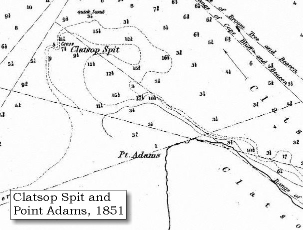
The water for a great distance off the mouth of the river, appears very shallow, and within the mouth nearest to point Adams [still Point Adams today], is a large sandbar [today Clatsop Spit extends into the mouth of the Columbia], almost covered at high tide.


Along the Journey - November 18, 1805
Map, Clatsop Spit, 1905

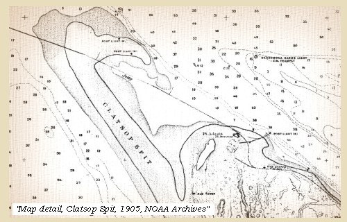
Clatsop Spit
Clatsop Spit, on the south side of the Columbia River entrance, is a low sand beach, extending about 2.5 miles northwest from Point Adams. This spit was formed after the Coast Range was uplifted. Sediments carried by the Columbia River were deposited by wind and wave action, building the spit over time. The jetty constructed (1885-1895) at the mouth of the Columbia River, caused additional accretion of the sand spit. -- NOAA Office of Coast Survey Website, 2003, U.S. National Park Service, Fort Clatsop National Memorial Website, 2002, and U.S. Army Corps of Engineers Website, 2002


Map, 1851, Point Adams and Clatsop Spit, click to enlarge Map, 1854, Point Adams, click to enlarge Map, 1905, Point Adams and Clatsop Spit, click to enlarge NASA Image, 2001, Mouth of the Columbia River, click to enlarge
  1. 1851 Map, Point Adams and Clatsop Spit, Oregon (section of original). (Click to enlarge). Compare to the 1854 map and 1905 map. Original Map: "Mouth of the Columbia River, Preliminary Survey, 1851". U.S. Coast Survey, 1851, #640, Scale 1:40,000. U.S. Office of Coast Survey Historical Map and Chart Collection #2228148. -- NOAA Archives Website, 2004
  2. 1854 Map, Point Adams, Oregon (section of original). (Click to enlarge). Compare to 1851 and 1905 maps. Original Map: "Entrance to Columbia River, Oregon, 1854". U.S. Coast Survey, 1854, Plate Number 416, U.S. Office of Coast Survey Historical Map and Chart Collection #928909. -- NOAA Archives Website, 2004
  3. 1905 Map, Point Adams and Clatsop Spit, Oregon (section of original). (Click to enlarge). Compare to the 1851 and 1854 maps for development of the Clatsop Spit. Original Map: "Columbia River, Sheet No.1, Entrance to Upper Astoria, 1905". U.S. Coast Survey, 1905, #6140, Scale 1:40,000. U.S. Office of Coast Survey Historical Map and Chart Collection #3853659. -- NOAA Archives Website, 2004
  4. 2001, NASA Image, Mouth of the Columbia River, including Clatsop Spit. (Click to enlarge). NASA Space Shuttle photograph of the mouth of the Columbia River, including the location of Fort Clatsop, Lewis and Clark National Wildlife Refuge, Tenasillahe Island, Puget Island, and Crim's Island, and others, June 20, 2001. NASA Astronaut Photography of Earth #SS002-724-30. -- NASA Astronaut Photography of Earth Website, 2002


We could not ascertain the direction of the deepest channel, for the waves break with tremendous force the whole distance across the bay, but the Indians point nearer to the opposite side as the best passage. After remaining for some time on this elevation, we descended across the low isthmus, and reached the ocean at the foot of a high hill [McKenzie Head, see above], about a mile in circumference, and projecting into the sea. We crossed this hill [McKenzie Head], which is open and has a growth of high coarse grass, and encamped on the north side of it, having made nineteen miles. Besides the pounded fish and brant, we had for supper a flounder, which we picked up on the beach.


Along the Journey - November 18, 1805
The Main Camp - November 15 through November 24, 1805:
"Station Camp", near today's McGowan, Washington.


Clark's Camp - November 18, 1805
On the beach, north side of McKenzie Head. The campsite was a log-strewn beach, as evidenced by photographs taken in 1890, prior to construction of the North Jetty after which the resultant accretion and forestation obliterated the site. The area of McKenzie Head is now the location of a monument marker placed by the Daughters of the American Revolution (DAR) on November 1, 2000. The granite marker commemorates the only known campsite of Lewis and Clark on the Washington Coast. -- Pacific County Friends of Lewis & Clark Website, 2002


Home Previous Continue


If you have questions or comments please contact: GS-CVO-WEB@usgs.gov
June/July 2004, Lyn Topinka
The Volcanoes of Lewis and Clark Home Page | CVO Home Page