The Volcanoes of
Lewis and Clark
November 8 - 9, 1805
Nearing the Pacific - Pillar Rock to Grays Point
 
Home
The Volcanoes of Lewis and Clark

Map of the Journey
Volcanoes, Basalt Plateaus, Major Rivers, etc.

The Volcanoes
Mount Adams, Mount Hood, Mount Jefferson, Mount Rainier, and Mount St. Helens

CALENDAR of the Journey
October 1805 to June 1806

Along the Journey
Pacific Northwest Maps - Columbia River, Volcanoes, Flood Basalts, Missoula Floods, Geology, etc.

The Corps of Discovery
The Journey of Lewis and Clark

About the Reference Materials
The Journals, Biddle/Allen, DeVoto, Gass, Moulton, Topo Maps, and others

USGS Lewis and Clark Links
Links to USGS Websites highlighting the Lewis and Clark Journey

Resources
Publications Referenced and Websites Visited


PREVIOUS

November 7
Nearing the Pacific, Wallace Island to Pillar Rock
November 8-9

Nearing the Pacific,
Pillar Rock to Grays Point

Pillar Rock, Coast Range, Saddle Mountain, Lewis and Clark NWR, Grays Bay, Deep River and Grays River, Miller Point, and Gray's Point
CONTINUE

November 10-11
Nearing the Pacific, Grays Point to Hungry Harbor
 

On October 7, 1805, Lewis and Clark and the "Corps of Discovery" began their journey down the Clearwater River and into the volcanics of the Pacific Northwest. The Corps travelled from the Clearwater to the Snake and down the "Great Columbia", finally reaching the Pacific Ocean on November 15, 1805. Along the journey they encountered the lava flows of the Columbia Plateau, river channels carved by the great "Missoula Floods", and the awesome beauty of five Cascade Range volcanoes.

Map, Lewis and Clark in the Pacific Northwest, click for brief
                         summary
[Click map for brief summary about the area]


To the Pacific - November 1805
Nearing the Pacific - Pillar Rock to Grays Point
 

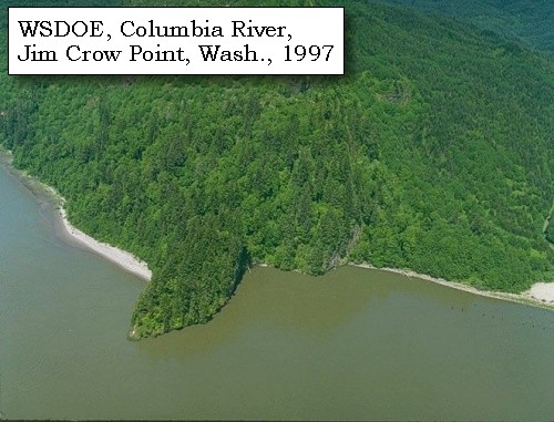
Lewis and Clark's camp of of November 7, 1805 was opposite Pillar Rock, between Brookfield and Dahlia, Washington, west of Jim Crow Point.

Friday, November 8, 1805
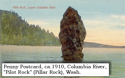
It rained this morning; and having changed the clothing which had been wet during yesterday's rain, we did not set out till nine o'clock. Immediately opposite our camp is a rock [Pillar Rock] at the distance of a mile in the river, about twenty feet in diameter and fifty in height,


Along the Journey - November 8, 1805
Pillar Rock, ca.1910

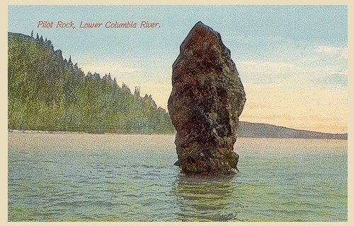
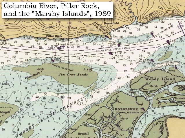
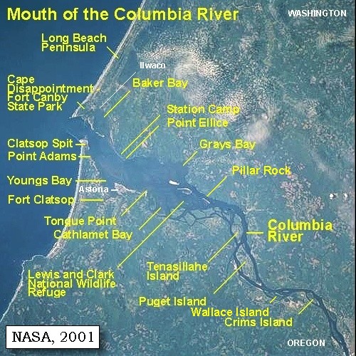
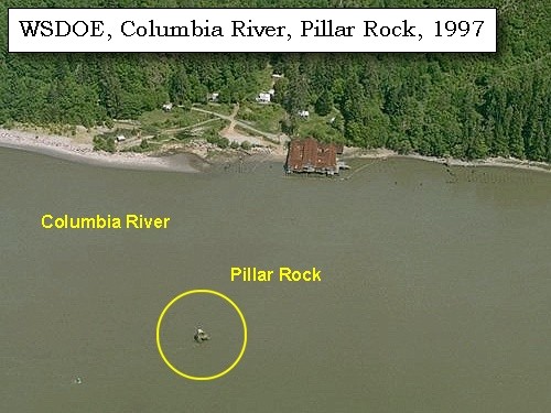
Pillar Rock:
Pillar Rock is a 70-foot high basaltic column sitting in water approximately 50 feet deep near the northern shore of the Columbia River. Simply marked "Rock" on Clark's route map, the basalt rock rose 75 to 100 feet above water level, depending on the tide. The landmark was given its present place name by Wilkes in 1841. Currently there is a navigation beacon located on top of Pillar Rock. -- U.S. National Park Service, Jefferson National Expansion Memorial Website, 2002, Pacific County Friends of Lewis and Clark Website, 2002, and Washington State Historical Society Website, 2002


Map, 1887, Pillar Rock vicinity, click to enlarge Map, 1989, Pillar Rock and Jim Crow Point, click to enlarge NASA Image, 2001, Mouth of the Columbia River, click to enlarge Penny Postcard, ca.1910, Pillar Rock, click to enlarge Image, 1997, Pillar Rock, click to enlarge Image, 1997, Jim Crow Point, click to enlarge
  1. 1887 Map (section of original), Columbia River and the Pillar Rock vicinity. (Click to enlarge). Original Map: The Columbia River from Celilo to the mouth showing locations of the salmon fisheries, 1887. Scale ca. 1:375,000, Relief shown by hachures. U.S. Army Corps of Engineers, Engineer Office, G.P.O. 1888. University of Washington Archives #UW128. -- University of Washington Library Archives Website, 2002
  2. 1989 Map, Pillar Rock and Jim Crow Point (section of original). (Click to enlarge). Office of Coast Surveys, Historical Maps and Charts, Columbia River, Harrington Point to Crims Island, 1989, Chart#18523, 1:40,000. -- NOAA Office of Coast Survey Website, 2004
  3. 2001, NASA Image, Mouth of the Columbia River, including the location of Fort Clatsop. (Click to enlarge). NASA Space Shuttle photograph of the mouth of the Columbia River, including the location of Fort Clatsop, the Lewis and Clark National Wildlife Refuge, Tenasillahe Island, Puget Island, and Crim's Island, June 20, 2001. NASA Astronaut Photography of Earth #SS002-724-30. -- NASA Astronaut Photography of Earth Website, 2002
  4. ca.1910, Penny Postcard, Pillar Rock. (Click to enlarge). Caption reads "Pilot Rock", Lower Columbia River. "Pilot Rock" is also known as "Pillar Rock". Published by the Portland Post Card Co. Date: ca.1907-1915. -- L.Topinka private collection, 2003, used with permission
  5. 1997, Aerial view, Pillar Rock. (Click to enlarge). Washington State Department of Ecology Shorelines Aerial Photo #WAH0033, May 13, 1997. -- Washington State Department of Ecology Website, 2002
  6. 1997, Aerial view, Jim Crow Point. (Click to enlarge). Washington State Department of Ecology Shorelines Aerial Photo #WAH0038, May 13, 1997. -- Washington State Department of Ecology Website, 2002


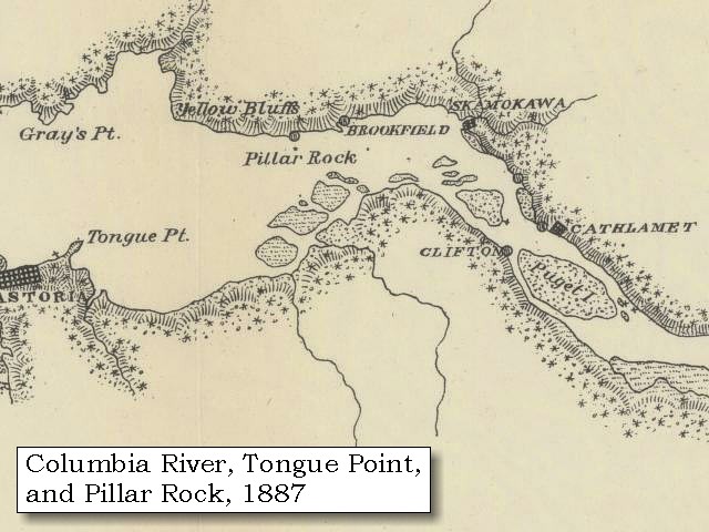
and towards the southwest some high mountains [Coast Range].,


Along the Journey - November 8, 1805
Coast Range:
The Coast Ranges, which border the entire west coast of the United States from the Olympic Peninsula south to Mexico, vary greatly in both rock type and climate. Upper Mesozoic and Tertiary sedimentary rocks predominate, although intrusive and metamorphic rocks are also present. Most rocks have been folded, faulted, and in places intensely sheared; many of the Tertiary rocks are poorly consolidated. Topography is mountainous, with steep slopes and intervening flat valleys. Precipitation in the Coast Ranges is seasonal, ranging from very wet in parts of the northern ranges to semiarid in the south, with periodic storms accompanied by intense rainfall. The combination of steep slopes, soft, sheared rocks, and periods of heavy precipitation makes this subdivision, particularly in California, one of the most landslide prone areas of the United States. Tectonic melange, especially that of the Franciscan assemblage, is especially slide prone; landslides on natural slopes are common in all three categories of slide, fall, and flow. Debris flows during rainstorms are a particular hazard in southern California, where much of the area is heavily developed, so that many landslides have been artificially activated. The Coast Ranges are seismically active, and earthquakes have triggered many landslides. -- Radbruch-Hall, et.al., 1982, USGS Professional Paper 1183


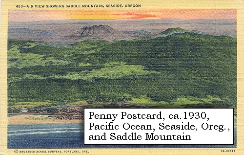
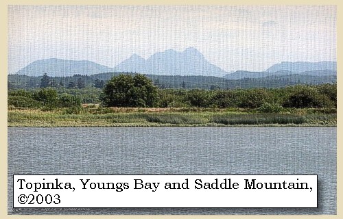
one of which is covered with snow at the top [Saddle Mountain].


Along the Journey - November 8, 1805
Saddle Mountain and Youngs Bay, 2003

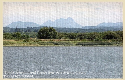
Saddle Mountain:
Saddle Mountain, at 3,283 feet elevation, is one of the highest peaks in the Coast Range, and affords a magnificent view of the surrounding mountains and the coast to the west. It is located 10 miles east of Seaside, Oregon, and is reached from the Sunset Highway (U.S. 26) a mile east of Necanicum Junction. A narrow paved road runs eight miles to the north from the highway to a large parking lot at the base of the mountain. A gentle, four-mile trail climbs nearly 1,500 feet from the parking lot to the forest fire lookout on the summit. The Saddle Mountain breccia (a rock consisting of broken angular fragments cemented together in a fine-grained matrix) is volcanic. It was produced about 15 million years ago by thermal shock, when a great lava flow of Columbia River basalt came down an ancestral valley of the Columbia River (south of its present course) and entered the Astoria Sea. The still-hot rock, meeting cold water, caused steam explosions which broke it up into a great pile of basalt fragments. Saddle Mountain appeared as "Mont de la Selle" on explorer John Meares' 1788 map of the Western coast of North America. -- Allen, 1987, and Deja View Antique Maps and Prints Website, 2004.


Map, 1855, Northwest Oregon and mouth Columbia River, click to enlarge Penny Postcard, ca.1930, Saddle Mountain and Seaside, Oregon, click to enlarge Image, 1972, Saddle Mountain, click to enlarge Image, 2003, Saddle Mountain and Youngs Bay
  1. 1855 Map, Northwest Oregon and mouth of the Columbia River (section of original). (Click to enlarge). Includes the Columbia River, Cape Disappointment, Point Adams, Saddle Mountain, Lewis and Clark River, Youngs River. Original Map: From the northern boundary of California to the Columbia River : from explorations and surveys / made under the direction of Hon. Jefferson Davis, Sec. of War by Lieut. R. S. Williamson, U.S. Topl. Engrs. and Lieut. H. L. Abbot, U.S. Topl. Engrs., H. C. Fillebrown, J. Young, and C. D. Anderson, Assts., 1855. Notes: Scale 1:760,320. Relief shown by hachures. At head of title: Routes in Oregon and California. Map no. 2. "Drawn by John Young." From U.S. War Department, Explorations and Surveys for a Railroad Route from the Mississippi River to the Pacific Ocean. Topographical Maps... to Illustrate the Various Reports... (Washington, 1859) Library of Congress American Memory Archives #G4290 1855 .W5 RR 170. -- U.S. Library of Congress Archives, 2004, "American Memory"
  2. ca.1930, Penny Postcard, Aerial view Saddle Mountain and Seaside, Oregon. (Click to enlarge). Air view showing Saddle Mountain and Seaside, Oregon, Brubaker Aerial Surveys, Oregon. #483, Wesley Andrews Co., Portland, Oregon. -- L.Topinka private collection, 2003, used with permission.
  3. 1972, Saddle Mountain. (Click to enlarge). Aerial photo of the Necanicum River entering the Pacific Ocean at Seaside, Oregon. Taken from over the ocean looking towards the east, this photograph shows the town of Seaside, the channel of the Necanicum as it enters the ocean, and Saddle Mountain in the background. Photograph Date: June 1, 1972. Oregon State Archives #OMB0031, Oregon State Marine Board. -- Oregon State Archives Website, 2002
  4. 2003, Saddle Mountain and Youngs Bay, as seen from Astoria, Oregon. (Click to enlarge). Copyright © 2003 Lyn Topinka, private archives, used with permission.


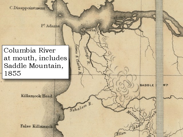
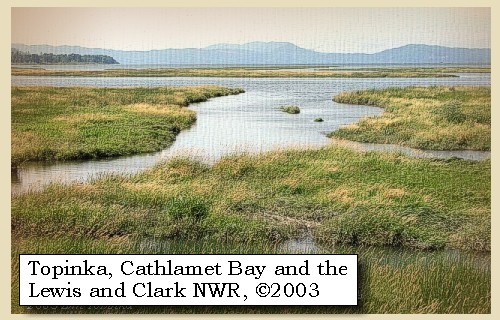
We proceeded past several low islands in the bay or bend of the river to the left [today's Lewis and Clark National Wildlife Refuge], which is here five or six miles wide.


Along the Journey - November 8, 1805
Cathlamet Bay, Lewis and Clark National Wildife Refuge, 2003

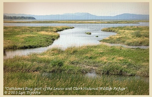
Lewis and Clark National Wildlife Refuge:
The Lewis and Clark National Wildlife Refuge was established in 1972 to preserve the estuary land and water as vital fish and wildlife habitat. The refuge includes 35,000 acres of islands, bars, mud flats and tidal marshes. The refuge is the largest marsh in western Oregon and provides habitat for peak populations of 3,000 tundra swans, 2,000 Canada geese and 5,000 ducks in February and March each year as they gather here before the northward migration. Woody, Horseshoe, Karlson, and Marsh islands are the main islands in the wildlife refuge on Oregon's side of the Columbia. In 1805, on their trip to the Pacific Ocean, Lewis and Clark referred to these islands simply as "marshy islands". On their return in 1806, they called this area "Seal Islands". -- U.S. Fish and Wildlife Service Website, 2003, Lewis and Clark Bicentennial in Oregon Website, 2002, and Washington State Historical Society Website, 2002


Map, 1855, Northwest Oregon and mouth Columbia River, click to enlarge Map, 1887, Map, 1989, Lewis and Clark NWR, 'Marshy Islands', click to enlarge NASA Image, 2001, Mouth of the Columbia River, click to enlarge Image, 2003, Cathlamet Bay, part of the Lewis and Clark NWR
  1. 1855 Map, Northwest Oregon and mouth of the Columbia River (section of original). (Click to enlarge). The "Marshy" or "Seal Islands" are depicted but not named (many islands left of tape). Includes the Columbia River, Cape Disappointment, Point Adams, Saddle Mountain, Lewis and Clark River, Youngs River. Original Map: From the northern boundary of California to the Columbia River : from explorations and surveys / made under the direction of Hon. Jefferson Davis, Sec. of War by Lieut. R. S. Williamson, U.S. Topl. Engrs. and Lieut. H. L. Abbot, U.S. Topl. Engrs., H. C. Fillebrown, J. Young, and C. D. Anderson, Assts., 1855. Notes: Scale 1:760,320. Relief shown by hachures. At head of title: Routes in Oregon and California. Map no. 2. "Drawn by John Young." From U.S. War Department, Explorations and Surveys for a Railroad Route from the Mississippi River to the Pacific Ocean. Topographical Maps... to Illustrate the Various Reports... (Washington, 1859) Library of Congress American Memory Archives #G4290 1855 .W5 RR 170. -- U.S. Library of Congress Archives, 2004, "American Memory"
  2. 1887 Map (section of original), Columbia River and the "Seal Islands" vicinity. (Click to enlarge). Original Map: The Columbia River from Celilo to the mouth showing locations of the salmon fisheries, 1887. Scale ca. 1:375,000, Relief shown by hachures. U.S. Army Corps of Engineers, Engineer Office, G.P.O. 1888. University of Washington Archives #UW128. -- University of Washington Library Archives Website, 2002
  3. 1989 Map, Lewis and Clark National Wildlife Refuge, "Marshy Islands" (section of original). (Click to enlarge). Office of Coast Surveys, Historical Maps and Charts, Columbia River, Harrington Point to Crims Island, 1989, Chart#18523, 1:40,000. -- NOAA Office of Coast Survey Website, 2004
  4. 2001, NASA Image, Mouth of the Columbia River, including the location of Fort Clatsop. (Click to enlarge). NASA Space Shuttle photograph of the mouth of the Columbia River, including the location of Fort Clatsop, the Lewis and Clark National Wildlife Refuge, Tenasillahe Island, Puget Island, and Crim's Island, June 20, 2001. NASA Astronaut Photography of Earth #SS002-724-30. -- NASA Astronaut Photography of Earth Website, 2002
  5. 2003, Cathlamet Bay, Oregon, part of the Lewis and Clark National Wildlife Refuge. (Click to enlarge). Copyright © 2003 Lyn Topinka, private archives, used with permission.


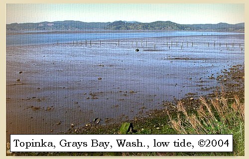
We were here overtaken by three Indians in a canoe who had salmon to sell. On the right side we passed an old village, and then, at the distance of three miles, entered an inlet or niche about six miles across [Grays Bay],


Along the Journey - November 8, 1805
Grays Bay, 2004

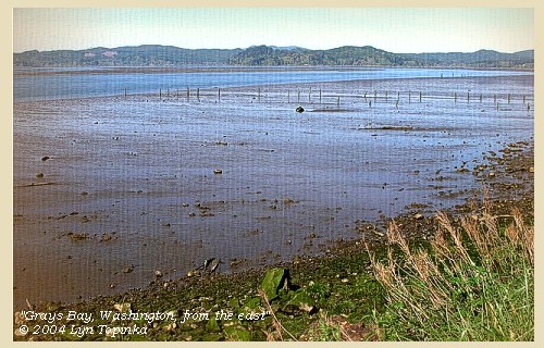
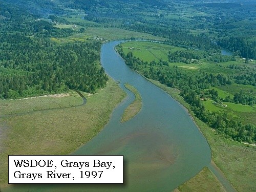
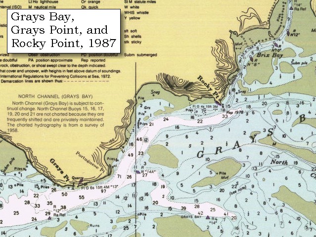
Grays Bay:
Grays Bay is located on the Washington side of the Columbia River, and extends from Grays Point to Harrington Point, north of the main shipping channel of the Columbia River. The northeastern section of the bay are extensive mud flats. This bay was given a descriptive name, "Shallow Bay," by Lewis and Clark as they coasted the shore on their way to the Pacific Ocean. The bay was named "Grays Bay" in 1792, when Captain Vancouver named the bay to honor Robert Gray, the American who first explored the mouth of the Columbia River. -- NOAA Office of Coast Survey Website, 2003, and Washington State Historical Society Website, 2002


Map, 1798, Mouth of the Columbia River, click to enlarge Map, 1814, Lewis and Clark on the Columbia, click to enlarge Map, 1887, Columbia River from mouth to Pillar Rock, click to enlarge Map, 1987, Grays Bay, Deep River, Miller Point, Grays River, click to enlarge NASA Image, 2001, Mouth of the Columbia River, click to enlarge Image, 2004, Grays Bay, Washington
  1. 1798 Map, Mouth of the Columbia River (section of original). (Click to enlarge). Inset map of original, showing the mouth of the Columbia River, including Cape Disappointment, Point Adams, Youngs River, Point George (today's Astoria), and Grays Bay. Original Map: George Vancouver's "A Chart Shewing Part of the Coast of N.W. America." In A Voyage of discovery to the North Pacific ocean, and Round the World. London, 1798. University of Virginia Special Collection "Lewis & Clark, The Maps of Exploration 1507-1814". -- University of Virginia Library Archives Website, 2004
  2. 1814 Map, Lewis and Clark's map of the Columbia River (section of original). (Click to enlarge.) Grays Bay is depicted but not named (large bay on north side of river, just under "Ch innook"). Map includes three of the five volcanoes Lewis and Clark saw and commented on. While the journals mention the expedition seeing Mount Adams, it does not appear on their map. Mount Jefferson is to the south (bottom) and off the map. From the "Nicholas Biddle/Paul Allen" 1814 publication. Original Map: "A Map of Lewis and Clark's Track, Across the Western Portion of North America, From the Mississippi to the Pacific Ocean". From: History of the expedition under the command of Captains Lewis and Clark : to the sources of the Missouri, thence across the Rocky Mountains and down the river Columbia to the Pacific Ocean : performed during the years 1804-5-6 : by order of the government of the United States / prepared for the press by Paul Allen. Philadelphia : Bradford and Insskeep, 1814. Harold B. Lee Library, Brigham Young University #upbover maps37. -- Brigham Young University, Harold B. Lee Library Website, 2004.
  3. 1887 Map, Columbia River from the Mouth to Pillar Rock (section of original). (Click to enlarge). Grays Bay (right of Grays Point) is depicted but not named. Original Map: The Columbia River from Celilo to the mouth showing locations of the salmon fisheries, 1887. Scale ca. 1:375,000, Relief shown by hachures. U.S. Army Corps of Engineers, Engineer Office, G.P.O. 1888. University of Washington Archives #UW128. -- University of Washington Library Archives Website, 2004
  4. 1987 Map, Grays Bay, Deep River, Miller Point, Grays River (section of original). (Click to enlarge). Office of Coast Surveys, Historical Maps and Charts, Columbia River, Pacific Ocean to Harrington Point, 1987, Chart#18521, 1:40,000. -- NOAA Office of Coast Survey Website, 2004
  5. 2001, NASA Image, Mouth of the Columbia River, including the location of Fort Clatsop. (Click to enlarge). NASA Space Shuttle photograph of the mouth of the Columbia River, including the location of Fort Clatsop, the Lewis and Clark National Wildlife Refuge, Tenasillahe Island, Puget Island, and Crim's Island, June 20, 2001. NASA Astronaut Photography of Earth #SS002-724-30. -- NASA Astronaut Photography of Earth Website, 2002
  6. 2004, Grays Bay, Washington, as seen from the east. (Click to enlarge). Copyright © 2003 Lyn Topinka, private archives, used with permission.


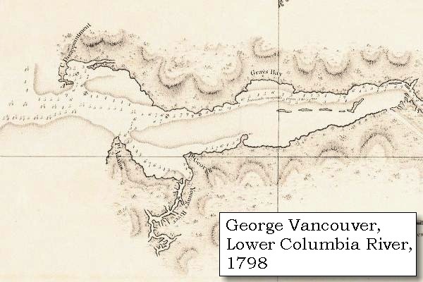
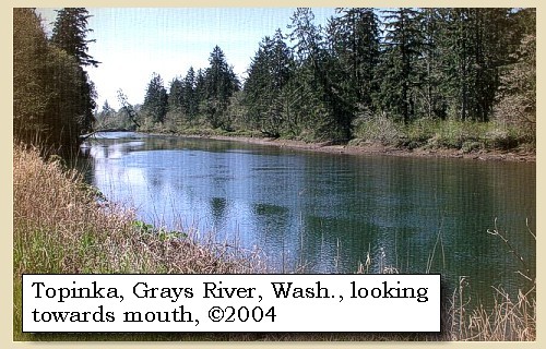
and making a deep bend of nearly five miles into the hills on the right shore, where it receives the waters of several creeks [Deep River (west) and Grays River (east) being the two largest].


Along the Journey - November 8, 1805
Grays River, 2004

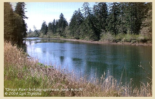
Deep River and Grays River:
Deep River flows into the northern part of Grays Bay. This river is used only by small pleasure craft and sport fishermen and for logging operations. Depths of about 6 feet are available for about 2 miles above it's mouth, above which it is shoal and probably good for no more than 2 feet. Grays River enters Grays Bay just east of Deep River, and is another small stream used only by pleasure craft. Depths are not more than 2 feet, and much of the stream is blocked by snags and sunken logs. -- NOAA Office of Coast Survey Website, 2003


Map, 1887, Columbia River from mouth to Pillar Rock, click to enlarge Map, 1987, Grays Bay, Deep River, Miller Point, Grays River, click to enlarge Image, 1997, Grays River, click to enlarge Image, 2004, Grays River, Washington
  1. 1887 Map, Columbia River from the Mouth to Pillar Rock (section of original). (Click to enlarge). Grays River (left of Yellow Bluff) is depicted but not named. Deep River is not depicted. Original Map: The Columbia River from Celilo to the mouth showing locations of the salmon fisheries, 1887. Scale ca. 1:375,000, Relief shown by hachures. U.S. Army Corps of Engineers, Engineer Office, G.P.O. 1888. University of Washington Archives #UW128. -- University of Washington Library Archives Website, 2004
  2. 1987 Map, Grays Bay, Deep River, Miller Point, Grays River (section of original). (Click to enlarge). Office of Coast Surveys, Historical Maps and Charts, Columbia River, Pacific Ocean to Harrington Point, 1987, Chart#18521, 1:40,000. -- NOAA Office of Coast Survey Website, 2004
  3. 1997, Aerial view, Grays River. (Click to enlarge). Washington State Department of Ecology Shorelines Aerial Photo #WAH0009, May 13, 1997. -- Washington State Department of Ecology Website, 2002
  4. 2004, Grays River, Washington, looking upstream from near mouth. (Click to enlarge). Copyright © 2004 Lyn Topinka, private archives, used with permission.


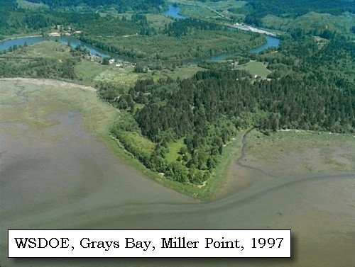
We coasted along this inlet [Grays Bay], which, from its little depth, we called Shallow bay, and at the bottom of it halted to dine near the remains of an old village [Miller Point], from which, however, we kept at a cautious distance, as it was occupied by great numbers of fleas. ......
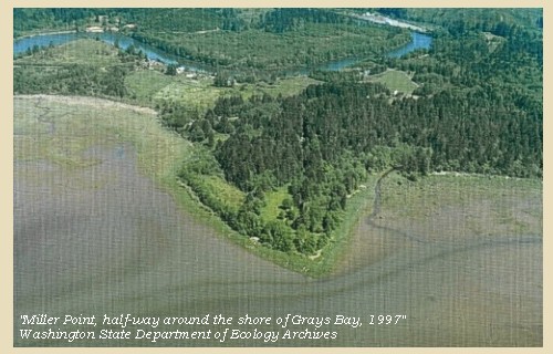

Along the Journey - November 8, 1805
Miller Point, 1997

Miller Point:


Map, 1987, Grays Bay, Deep River, Miller Point, Grays River, click to enlarge Image, 1997, Miller Point, click to enlarge
  1. 1987 Map, Grays Bay, Deep River, Miller Point, Grays River (section of original). (Click to enlarge). Office of Coast Surveys, Historical Maps and Charts, Columbia River, Pacific Ocean to Harrington Point, 1987, Chart#18521, 1:40,000. -- NOAA Office of Coast Survey Website, 2004
  2. 1997, Aerial view, Miller Point. (Click to enlarge). Washington State Department of Ecology Shorelines Aerial Photo #WAH0007, May 13, 1997. -- Washington State Department of Ecology Website, 2002


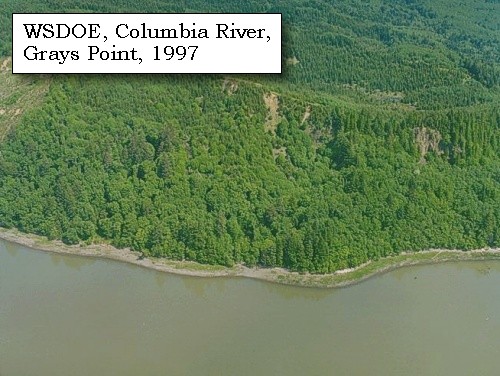
After dinner the three Indians left us, and we then took advantage of the returning tide, to go on about three miles to a point on the right [Grays Point], eight miles distant from our camp; but here the waves ran so high, and dashed about our canoes so much, that several of the men became seasick. It was therefore judged imprudent to go on in the present state of weather, and we landed at the point [Grays Point].


Along the Journey - November 8, 1805
Grays Point, Washington, 2004

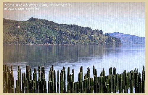
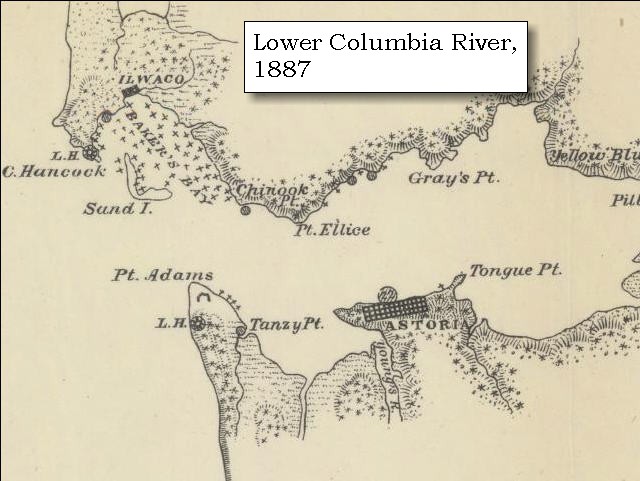
Grays Point:
Grays Point was charted by Charles Wilkes in 1841 and named to honor the American explorer who first explored the Columbia River in 1792. Grays Point is the western point of Grays Bay. -- Washington State Historical Society Website, 2004, "Lasting Legacy"


Map, 1887, Mouth of the Columbia River, click to enlarge Map, 1987, Grays Point, click to enlarge Image, 1997, Grays Point, click to enlarge Image, 2004, West side of Grays Point
  1. 1887 Map (section of original), Mouth of the Columbia River. (Click to enlarge). Original Map: The Columbia River from Celilo to the mouth showing locations of the salmon fisheries, 1887. Scale ca. 1:375,000, Relief shown by hachures. U.S. Army Corps of Engineers, Engineer Office, G.P.O. 1888. University of Washington Archives #UW128. -- University of Washington Library Archives Website, 2002
  2. 1987 Map, Grays Point (section of original). (Click to enlarge). Office of Coast Surveys, Historical Maps and Charts, Columbia River, Pacific Ocean to Harrington Point, 1987, Chart#18521, 1:40,000. -- NOAA Office of Coast Survey Website, 2004
  3. 1997, Aerial view, Grays Point. (Click to enlarge). Washington State Department of Ecology Shorelines Aerial Photo #PAC0640, May 13, 1997. -- Washington State Department of Ecology Website, 2002
  4. 2004, West side of Grays Point, Washington, as seen from the old Knappton Mill pilings off of Washington State Highway 401. (Click to enlarge). Copyright © 2004 Lyn Topinka, private archives, used with permission.


The situation was extremely uncomfortable; the high hills jutted in so closely that there was not room for us to lie level, nor to secure our baggage free from the tide; and the water of the river is to salt to be used; but the waves increasing every moment so much, that we could not move from the spot with safety: we therefore fixed ourselves on the beach left by the ebb-tide, and having raised the baggage on poles, passed a disagreeable night, the rain during the day having wet us completely, as indeed we have been for some days past.


Along the Journey - November 8 and 9, 1805
The Camp - November 8 and November 9, 1805:
Washington side of the Columbia River, west side of Grays Bay, at a place now called "Grays Point".


Saturday, November 9, 1805

Fortunately for us, the tide did not rise as high as our camp during the night; but being accompanied by high winds from the south, the canoes, which we could not place beyond its reach, were filled with water, and were saved with much difficulty: our position was very uncomfortable, but as it was impossible to move from it, we waited for a change of weather. It rained, however, during the whole day, and at two o'clock in the afternoon, the flood tide set in, accompanied by a high wind from the south, which, about four o'clock, shifted to the southwest, and blew almost a gale directly from the sea. The immense waves now broke over the place where we were encamped, and the large trees, some of them five or six feet thick, which had lodged at the point, were drifted over our camp, and the utmost vigilance of every man could scarcely save our canoes from being crushed to pieces. We remained in the water and drenched with rain during the rest of the day; our only food being some dried fish, and some rain-water which we caught. Yet, though wet and cold, and some of them sick from using the salt-water, the men are cheerful, and full of anxiety to see more of the ocean. The rain continued all night ......


Along the Journey - November 8 and 9, 1805
The Camp - November 8 and November 9, 1805:
Washington side of the Columbia River, west side of Grays Bay, at a place now called "Grays Point".


Home Previous Continue


If you have questions or comments please contact: GS-CVO-WEB@usgs.gov
June/July 2004, Lyn Topinka
The Volcanoes of Lewis and Clark Home Page | CVO Home Page