The Volcanoes of
Lewis and Clark
November 2, 1805
Columbia River Gorge - Beacon Rock to Rooster Rock
 
Home
The Volcanoes of Lewis and Clark

Map of the Journey
Volcanoes, Basalt Plateaus, Major Rivers, etc.

The Volcanoes
Mount Adams, Mount Hood, Mount Jefferson, Mount Rainier, and Mount St. Helens

CALENDAR of the Journey
October 1805 to June 1806

Along the Journey
Pacific Northwest Maps - Columbia River, Volcanoes, Flood Basalts, Missoula Floods, Geology, etc.

The Corps of Discovery
The Journey of Lewis and Clark

About the Reference Materials
The Journals, Biddle/Allen, DeVoto, Gass, Moulton, Topo Maps, and others

USGS Lewis and Clark Links
Links to USGS Websites highlighting the Lewis and Clark Journey

Resources
Publications Referenced and Websites Visited


PREVIOUS

November 1
Columbia River Gorge, Cascade Locks to Bonneville - The Portage
November 2

Columbia River Gorge,
Beacon Rock to Rooster Rock

Rapids below Bradford Island, Hamilton Island, Pierce NWR, Beacon Rock and Beacon Rock State Park, Franz Lake NWR, Columbia Gorge National Scenic Area, Yeon Mountain (St. Peter's Dome), Multnomah Falls, Lava Flows and Waterfalls, Phoca Rock, Cape Horn, Rooster Rock and Rooster Rock State Park, Point Vancouver
CONTINUE

November 3
Columbia River Heading West, Rooster Rock to Columbia River Slough
 

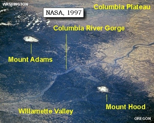
On October 7, 1805, Lewis and Clark and the "Corps of Discovery" began their journey down the Clearwater River and into the volcanics of the Pacific Northwest. The Corps travelled from the Clearwater to the Snake and down the "Great Columbia", finally reaching the Pacific Ocean on November 15, 1805. Along the journey they encountered the lava flows of the Columbia Plateau, river channels carved by the great "Missoula Floods", and the awesome beauty of five Cascade Range volcanoes.

Map, Lewis and Clark in the Pacific Northwest, click for brief
                         summary
[Click map for brief summary about the area]


To the Pacific - November 1805
Columbia River Gorge - Beacon Rock to Rooster Rock
 

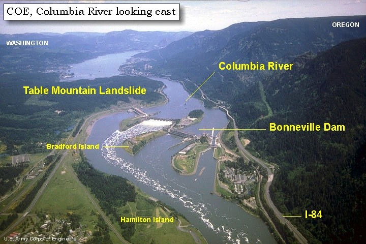
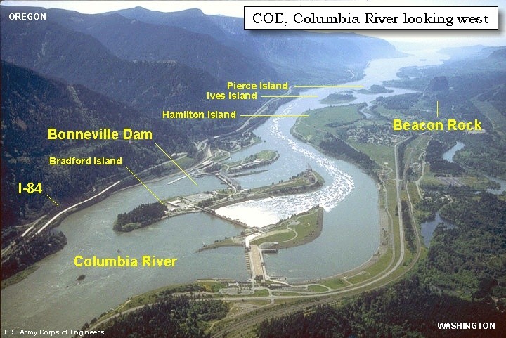
Lewis and Clark's camp of November 1, 1805 was on the Washington side of the Columbia River, downstream of today's Bonneville Dam, near the towns of Fort Rains and North Bonneville.

Saturday, November 2, 1805
We now examined the rapid below more particularly [and a mile and a half downstream of Bradford Island], and the danger appearing to be too great for the loaded canoes, all those who could not swim were sent with the baggage by land. The canoes then passed safely, and were reloaded; at the foot of the rapid we took a meridian altitude of 59? 45' 45"


Along the Journey - November 2, 1805
USGS Topo Map, Bonneville vicinity, 1911

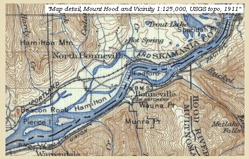
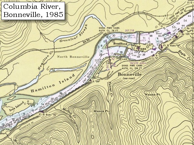
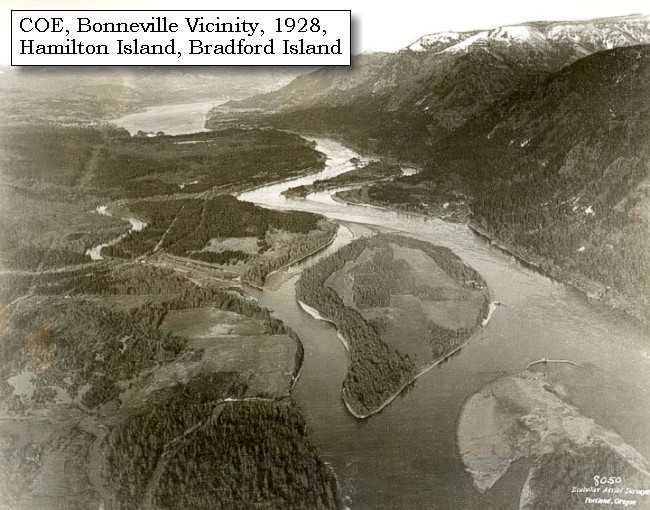
Rapids below Bradford Island:


Map, 1911 USGS topo map of the Bonneville area, click to enlarge Map, 1985, Bonneville Vicinity, click to enlarge
  1. 1911 Map (section of original), from Mount Hood and Vicinity 1:125,000 topographic quadrangle. (Click to enlarge). Original map surveyed in 1907 and 1909-1911, contour interval of 100 feet. -- University of Washington Library Collections Website, 2002
  2. 1985 Map (section of original), Bonneville Vicinity, including Hamilton Island, Bradford Island, and Bonneville Dam. (Click to enlarge). Office of Coast Surveys, Historical Maps and Charts, Columbia River, Vancouver to Bonneville, 1985, Chart#18531, 1:40,000. -- NOAA Office of Coast Survey Website, 2004


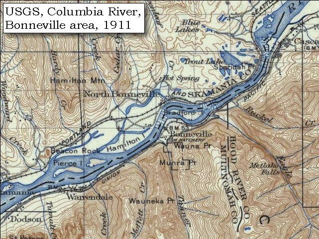
Just as we were setting out seven squaws arrived across the portage loaded with dried fish and bear-grass, neatly packed in bundles, and soon after four Indians came down the rapid in a large canoe. After breakfasting we left our camp at one o'clock, passed the upper point of an island [Hamilton Island] which is separated from the right shore by a narrow channel, through which in high tides the water passes. But at present it contains no running water, and a creek which falls into it from the mountains on the right [Hamilton Creek], is in the same dry condition, though it has the marks of discharging immense torrents at some seasons. The island [Hamilton Island] thus made is three miles in length and about one in width; its situation is high and open, the land rich, and at this time covered with grass and a great number of strawberry vines, from which we gave it the name of Strawberry island. In several places we observed that the Indians had been digging for roots, and indeed the whole island bears every appearance of having been at some period in a state of cultivation.


Along the Journey - November 2, 1805
Hamilton Island, 1928

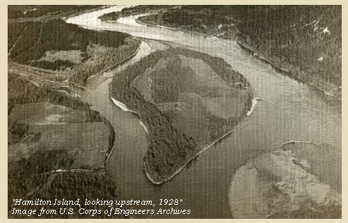
Hamilton Island:
Lewis and Clark called this island "Strawberry Island", as it seemed to be cultivated with woodland strawberry vines. The physiography of Hamilton Island has changed greatly since Lewis and Clark's time with the construction of Bonneville Dam. -- Washington State Historical Society Website, 2004, "Lasting Legacy"


Map, 1911 USGS topo map of the Bonneville area, click to enlarge Map, 1948, Bonneville Dam, Hamilton Island, Bradford Island, click to enlarge Map, 1985, Bonneville Vicinity, click to enlarge Image, 1928, Columbia River and Hamilton and Bradford Islands, click to enlarge Image, Aerial view, Bonneville Dam, looking east, annotated, click to enlarge Image, Aerial view, Bonneville Dam, looking west, annotated, click to enlarge
  1. 1911 Map (section of original), from Mount Hood and Vicinity 1:125,000 topographic quadrangle. (Click to enlarge). Original map surveyed in 1907 and 1909-1911, contour interval of 100 feet. -- University of Washington Library Collections Website, 2002
  2. 1948 Map (section of original), Bonneville area including Bonneville, Bonneville Dam, Hamilton Island, and Bradford Island. (Click to enlarge). Office of Coast Surveys, Historical Maps and Charts, Columbia River, Vancouver to Bonneville, 1948, Chart#6156, 1:40,000. -- NOAA Office of Coast Survey Website, 2004
  3. 1985 Map (section of original), Bonneville Vicinity, including Hamilton Island, Bradford Island, and Bonneville Dam. (Click to enlarge). Office of Coast Surveys, Historical Maps and Charts, Columbia River, Vancouver to Bonneville, 1985, Chart#18531, 1:40,000. -- NOAA Office of Coast Survey Website, 2004
  4. 1928, Columbia River, Hamilton and Bradford Islands, and vicinity, prior to the construction of the Bonneville Lock and Dam. (Click to enlarge). View is looking upstream with Washington State on the left and Oregon on the right. The Bonneville Landslide is prominent jutting into the Columbia River from the Washington side (upper third of photo). Hamilton Island is the big island in the foreground and Bradford Island is across from the Bonneville Landslide. U.S. Corps of Engineers Historical Archives #700-64. Photograph Date: April 11, 1928. -- U.S. Army Corps of Engineers Website, 2002
  5. Aerial view, Columbia River and Bonneville Dam, looking east, annotated. (Click to enlarge). Washington State is on the left with a good view of the Bonneville Landslide jutting into the Columbia River. Oregon is on the right. Bradford Island is crossed by the Bonneville Dam. Hamilton Island is in the foreground. Annotation includes Columbia River, Bonneville Dam, Interstate 84, Bonneville Landslide, Hamilton Island, and Bradford Island. -- U.S. Army Corps of Engineers Website, 2003
  6. Aerial view, Columbia River and Bonneville Dam, looking west, annotated. (Click to enlarge). Oregon is on the left and Washington State is on the right. Includes annotation for the Columbia River, Bonneville Dam, I-84, Bradford Island, Hamilton Island, Ives Island, Pierce Island, and Beacon Rock. -- U.S. Army Corps of Engineers Website, 2003


On the left side of the river the low ground is narrow and open: the rapid which we have just passed [below Bonneville Dam] is the last of all the descents of the Columbia. At this place the first tide-water commences, and the river in consequence widened immediately below the rapid. As we descended, we reached at the distance of one mile from the rapid a creek under a bluff on the left [Tanner Creek], at three miles is the lower point of Strawberry island [Hamilton Island]. To this immediately succeed three small islands covered with wood [two islands today, Pierce and Ives Islands]; in the meadow to the right [Hardy Creek and today's Pierce National Wildlife Refuge],


Along the Journey - November 2, 1805
Pierce National Wildlife Refuge:
Pierce National Wildlife Refuge consists of 336 acres of river bottomland habitat with riparian areas, wetlands, grasslands, and hardwoods. The refuge provides habitat for Canada geese, a variety of other waterfowl, and numerous other wildlife species. Hardy Creek supports one of the last remaining chum salmon runs in the lower Columbia River drainage. The south end of the refuge can be viewed from the Beacon Rock trail. -- U.S. Fish and Wildlife Service Website, 2003


and at some distance from the hills, stands a high perpendicular rock, about eight hundred feet high, and four hundred yards round the base; this we called the Beacon rock. [Beacon Rock]
"... 5 miles to a timbered bottom on the Lard. Side, passed the Lowr. point of Strawbery Isd. at 3 miles, a Isd Covd with wood below on Stard. Side a remarkable high rock on Stard. Side about 800 feet high & 400 yds round, the 'Beaten' Rock. The mountains and bottoms thickly timbered with Pine Spruce Cotton and a kind of maple ..." [Clark, November 2, 1805, first draft]


Along the Journey - November 2, 1805
Beacon Rock basalt columns, 2003

Beacon Rock and Beacon Rock State Park:
Beacon Rock is an eroded olivine basalt plug that rises 840 feet above river level. The ice-age floods through the Columbia River Gorge eroded the softer material away, leaving this unique geological structure standing by itself on the northern bank of the Columbia River. This basalt monolith is second in size only to the Rock of Gibraltar. "Beacon Rock" was originally named by Lewis and Clark on their expedition to the Pacific Ocean, altho in Clark's journal he calls it "Beaton Rock", a spelling which was corrected by Lewis and also corrected in the Biddle/Allen publication of 1814. It was near Beacon Rock that they first measured tidal influences from the ocean on the Columbia River. In 1811, Alexander Ross of the John Jacob Astor expedition called the rock "Inoshoack Castle." The rock was known as "Castle Rock" until 1916 when the United States Board of Geographic Names restored the name "Beacon Rock". Henry J. Biddle (an heir of Nicholas Biddle, editor of the 1814 journals) purchased the rock, built a trail to the top, and in 1935 his heirs turned the rock over to the state for use as a park. Additional development was done by the Civilian Conservation Corps. Today, Beacon Rock stands at the head of Washington State's Beacon Rock State Park. -- Norman and Roloff, 2004, Washington State DNR Open-File Report 2004-7, Washington State Historical Society Website, 2004, "Lasting Legacy", and Washington State Parks and Recreation Website, 2001.


Map, the Volcanoes of Lewis and Clark, click to enlarge Map, 1911 USGS topo map of the Beacon Rock area, click to enlarge Map, 1985, Beacon Rock vicinity, click to enlarge Image, ca.1879-1909, Beacon Rock, click to enlarge Image, ca. 1902, Beacon Rock, click to enlarge Image, 1913, Beacon Rock from above, click to enlarge Image, 1915, Downstream Columbia River towards Beacon Rock, click to enlarge Image, 1927, Beacon Rock, click to enlarge Image, 1927, Downstream Columbia River towards Beacon Rock, click to enlarge Image, 2003, Beacon Rock basalts, click to enlarge
  1. Location Map, Volcanoes of Lewis and Clark, November 2, 1805, Lewis and Clark pass Beacon Rock (#3)
  2. 1911 Map (section of original), from Mount Hood and Vicinity 1:125,000 topographic quadrangle. (Click to enlarge). Map shows the Columbia River Gorge from Bonneville Dam downstream to Multnomah Falls. Includes Bonneville, Bradford Island, Hamilton Island, Beacon Rock, St. Peters Dome, and Oneonta Hills. Original map surveyed in 1907 and 1909-1911, contour interval of 100 feet. -- University of Washington Library Collections Website, 2002
  3. 1985 Map (section of original), Beacon Rock vicinity, including Pierce and Ives Islands, and Hamilton Island. (Click to enlarge). Office of Coast Surveys, Historical Maps and Charts, Columbia River, Vancouver to Bonneville, 1985, Chart#18531, 1:40,000. -- NOAA Office of Coast Survey Website, 2004
  4. ca.1879-1909, "Castle Rock" (today's Beacon Rock, Washington). (Click to enlarge). A scene in the region served by the Oregon Railway & Navigation Company between 1879 and 1909. "Castle Rock" is now known as "Beacon Rock". Oregon State Archives, Salem Public Library Collection #0RN1. Photograph Date: ca.1879-1909. -- Oregon State Archives Website, 2002
  5. ca.1902, Beacon Rock looking north. (Click to enlarge). "Castle Rock - looking north", by Lily E. White, ca. 1902. Oregon Historical Society Archives #OrHi67893. -- Oregon Historical Society Archives Website, 2002
  6. 1913, Columbia River and Beacon Rock from upstream. (Click to enlarge). Photo by Albert Henry Barnes, ca.1913. University of Washington A.H. Barnes Collection. -- University of Washington Library Archives, 2003
  7. 1915, The Columbia River downstream of Beacon Rock. (Click to enlarge). Columbia River Highway near Multnomah Falls, Beacon Rock in the background. By George Weister, 1915. Oregon Historical Society #OrHi70768. -- Oregon Historical Society Archives Website, 2002
  8. 1927 photograph of Castle Rock (now known as Beacon Rock), located on the north side of the Columbia River, in Skamania County, Washington. The wooden fishing platforms stretch out into the river, and were used for dip netting and spear fishing for salmon. (Click to enlarge). Oregon State Archives, Private Donation #OPD0011, Photograph Date: 1927. -- Oregon State Archives Website, 2002
  9. 1927, The Columbia River downstream of Beacon Rock. (Click to enlarge). Photograph of the Columbia River Highway, U.S. Highway 30, in the Columbia River Gorge. The highway was constructed between 1913 and 1922. Beacon Rock in in the background. Photograph Date: 1927. Oregon State Archives, Private Donation #OPD0022. -- Oregon State Archives Website, 2002
  10. 2003, Beacon Rock basalt columns. (Click to enlarge). Copyright © 2003 Lyn Topinka, private archives, used with permission.


Just below is an Indian village of nine houses, situated between two small creeks [Woodward Creek and Duncan Creek]. At this village the river widens to nearly a mile in extent, the low grounds too become wider, and they as well as the mountains on each side are covered with pine, spruce-pine, cottonwood, a species of ash, and some alder. [today this area includes the Franz National Wildlife Refuge]


Along the Journey - November 2, 1805
Franz Lake National Wildlife Refuge:
Franz Lake National Wildlife Refuge contains more than 500 acres of river bottomland and upland riparian habitat with numerous springs, seeps and creeks, grasslands, hardwood and upland forests. Franz Lake is one of the few remaining natural wetlands in the Columbia River Gorge. The refuge provides critical habitat for tundra swans and other waterfowl and year-round habititat for a variety of wildlife species. Visitors can view the refuge from a scenic overlook on Washington State Highway 14. -- U.S. Fish and Wildlife Service Website, 2003


After being so long accustomed to the dreary nakedness of the country above, the change is as grateful to the eye, as it is useful in supplying us with fuel. [Lewis and Clark are within today's Columbia River Gorge National Scenic Area]


Along the Journey - November 2, 1805
Columbia River Gorge National Scenic Area, 2003

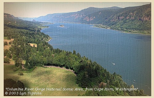
Columbia River Gorge National Scenic Area:
Lewis and Clark have entered what is today the "Columbia River Gorge National Scenic Area". The Columbia River Gorge is a spectacular river canyon cutting the only sea-level route through the Cascade Mountain Range. The Gorge is 80 miles long and up to 4,000 feet deep, with the north canyon walls in Washington State and the south canyon walls in the State of Oregon. The "Gorge" is located approximately 20 miles east of Portland, Oregon, with Visitor Centers being located at Skamania Lodge, Multnomah Falls, the Gorge Discover Center in The Dalles, and at Bonneville Dam. -- U.S. Forest Service Website, 2002, and Lewis and Clark Bicentennial "lewisandclar200.gov" Website, 2002


NASA Image, 1994, Columbia River Gorge, Mount Hood, Mount Adams, and Mount St. Helens, click to enlarge NASA Image, 1997, Columbia River, Mount Hood, and Mount Adams, click to enlarge Image, 1927, Columbia River Gorge including Phoca Rock, click to enlarge Image, 2003, Columbia River Gorge from Cape Horn
  1. 1994, NASA Image, Columbia River Gorge (section of original). (Click to enlarge). View from space - Columbia River and the Columbia River Gorge, west-northwest-looking, low-oblique photograph, September 1994. The Columbia River is running from the bottom (east) to the top (west). The Cascade Range is the dark color through the middle of the image, with Mount Hood on the Oregon side of the Columbia and Mount Adams and Mount St. Helens on the Washington side of the Columbia. NASA Earth from Space #STS064-112-092. -- NASA Earth from Space Website, 2002
  2. 1997, NASA Image, Columbia River looking northeast, with Mount Adams and Mount Hood (Click to enlarge). View from space - Columbia River, Willamette Valley, Columbia Plateau, Mount Adams, and Mount Hood. In this northeast-looking photograph the Columbia River flows right (east) to left (west). NASA Earth from Space #STS085-734-085. -- NASA Earth from Space Website, 2002
  3. 1927, Columbia River Gorge, Crown Point, Vista House, and Phoca Rock. (Click to enlarge). Vista House was constructed in 1916 to provide a vantage point and rest stop for motorists. It provides a spectacular view of the gorge. Phoca Rock (dark speck) is in the middle of Columbia. Photograph Date: 1927. Oregon State Archives, Private Donation #OPD0019. -- Oregon State Archives Website, 2003
  4. 2003, Columbia River Gorge National Scenic Area, as seen from Cape Horn, Washington. (Click to enlarge). Beacon Rock is in the distance, left. Copyright © 2003 Lyn Topinka, private archives, used with permission.


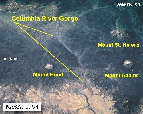
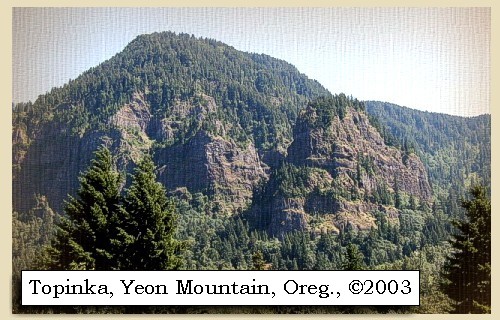
Yeon Mountain is a lava flow features which make the Columbia River Gorge spectacular. Yeon Mountain is located on the Oregon side of the Columbia River.


Along the Journey - November 2, 1805
Yeon Mountain, 2003

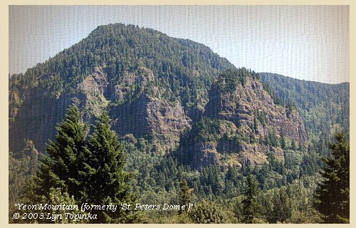
Yeon Mountain (St. Peter's Dome):
Yeon Mountain at one time was called "St. Peter's Dome", before current usage transfered that name to a basalt feature west.


Map, 1911 USGS topo map of the Beacon Rock area, click to enlarge Image, ca.1902, St. Peter's Dome, click to enlarge Image, 2003, Yeon Mountain
  1. 1911 Map (section of original), from Mount Hood and Vicinity 1:125,000 topographic quadrangle. (Click to enlarge). Map shows the Columbia River Gorge from Bonneville Dam downstream to Multnomah Falls. Includes Bonneville, Bradford Island, Hamilton Island, Beacon Rock, St. Peters Dome, and Oneonta Hills. Original map surveyed in 1907 and 1909-1911, contour interval of 100 feet. -- University of Washington Library Collections Website, 2002
  2. ca.1902, St. Peter's Dome. (Click to enlarge). "St. Peter's Dome, height 3,010 feet", by Maud Ainsworth, ca.1902. Oregon Historical Society Archives #OrHi67897. -- Oregon Historical Society Archives Website, 2002
  3. 2003, Yeon Mountain (formerly St. Peter's Dome), Columbia River Gorge. (Click to enlarge). Copyright © 2003 Lyn Topinka, private archives, used with permission.


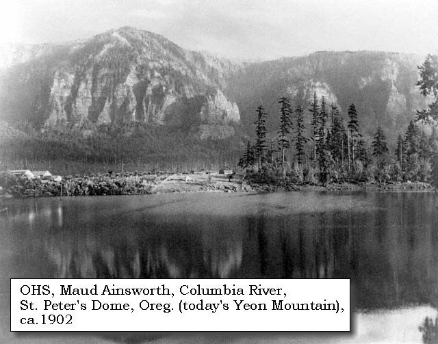
Numerous waterfalls are within the Columbia Gorge National Scenic area.


Along the Journey - November 2, 1805
Multnomah Falls, Oregon, 2003

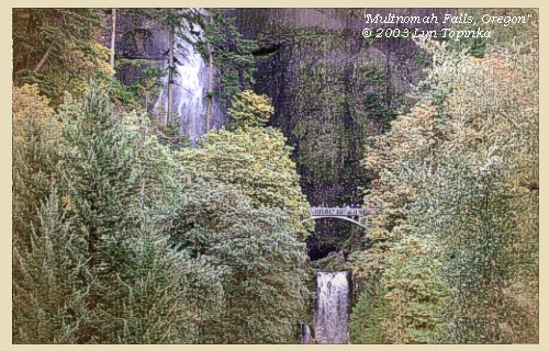
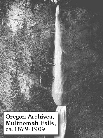
Multnomah Falls:
Multnomah Falls, plummeting 620 feet from its origins on Larch Mountain, is the second highest year-round waterfall in the United States. Nearly two million visitors a year come to see this ancient waterfall making it Oregon's number one public destination. Fed by underground springs from Larch Mountain, the flow over the falls varies usually being highest during winter and spring. Multnomah Falls offers one of the best places in the Columbia River Gorge National Scenic Area to study geology exposed by floods. Five flows of Yakima basalt are visible in the fall's cliff face. The two falls are produced because of a more easily eroded zone at the base of the upper falls. -- U.S. Forest Service Website, 2002, and Beeson and Tolan, 1987


Map, 1911 USGS topo map of the Multnomah Falls area, click to enlarge Image, ca.1879-1909, Multnomah Falls, click to enlarge Image, 2003, Multnomah Falls, Oregon
  1. 1911 Map (section of original), from Mount Hood and Vicinity 1:125,000 topographic quadrangle. (Click to enlarge). Original map surveyed in 1907 and 1909-1911, contour interval of 100 feet. -- University of Washington Library Collections Website, 2002
  2. ca.1879-1909, Multnomah Falls, Columbia River Gorge. (Click to enlarge). Pictured is a scene in the region served by the Oregon Railway & Navigation Company between 1879-1909. Oregon State Archives, Salem Public Library Collection. Photograph Date: 1879-1909, -- Oregon State Archives Website, 2002
  3. 2003, Multnomah Falls, Oregon. (Click to enlarge). Copyright © 2003 Lyn Topinka, private archives, used with permission.


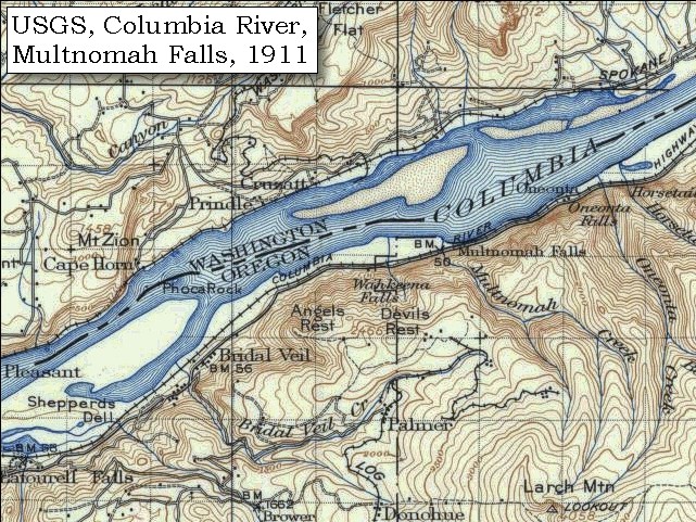
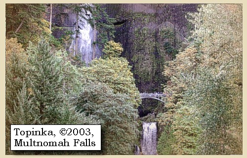
Lava Flows and Waterfalls:
The presence of prominent vertical cooling joints in most of the lava flows, combined with the weak interflow zones result in steep cliffs and abundant waterfalls. Observations of waterfalls occurring over Columbia River basalt flows have shown that falls often occur where flows are flat lying or dipping upstream. This condition allows blocks produced by vertical cooling joints to be stable until support is withdrawn by erosion of the weaker interflow material at the base of the flows. The rate of erosion of interflow material probably largely controls the rate of retreat of the falls. The amphitheater-shaped valley common to many of the falls within the gorge is due to freeze-thaw action of water from splash mist that penetrates the joints. Most waterfalls are limited to the Oregon side of the Columbia River Gorge because landslides modify the steepness on the Washington side. The entire region's bedrock material is tilted slightly southward. When it is water saturated, the upper basaltic layers on the north side of the river slide into the Gorge. Thus, waterfalls on the Washington side are fewer and smaller. -- Beeson and Tolan, 1987


Four miles from the village is a point of land on the right, where the hills become lower, but are still thickly timbered. The river is now about two miles wide, the current smooth and gentle, and the effect of the tide has been sensible since leaving the rapid. Six miles lower is a rock rising from the middle of the river to the height of one hundred feet, and about eighty yards at its base [Phoca Rock, the Biddle/Allen version says "eighty yards at its base" whereas the original journals have "eighty feet", see quotation below].
"... passed a rock at 10 miles in the middle of the river this rock is 100 feet high & 80 feet Diameter ..." [Clark, November 2, 1805, first draft]
"... at 17 miles passed a rock near the middle of the river, about 100 feet high and 80 feet Diameter, ..." [Clark, November 2, 1805]


Along the Journey - November 2, 1805
Phoca Rock, ca.1910

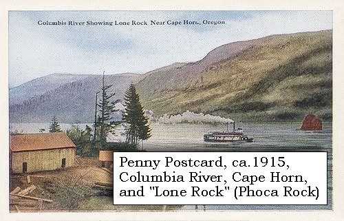
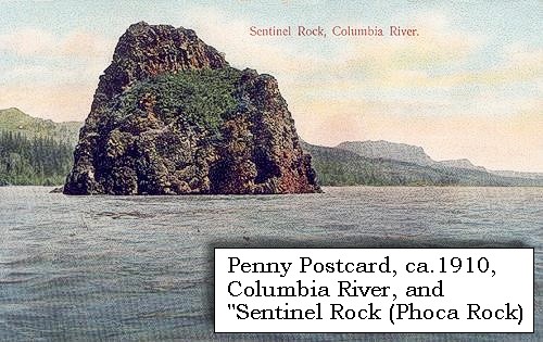
Phoca Rock:
Lewis and Clark named "Phoca Seal rock" for the harbor seal. [Clark noted in the winter of 1805-6 'Pho ca' rock in midl. Rivr. 100 foot high Saw Seal's] The 30-foot lone rock rises out of the river and derives its designation from the Greek word for "seal." The basalt formation in the river was known as "Lone Rock" until the U.S. Bureau of Geographic Names established its present place name, honoring a Lewis and Clark name for the small geographical feature in the river. -- Washington State Historical Society Website, 2004, "Lasting Legacy".


Map, 1911, USGS topo map of the Rooster Rock - Phoca Rock area, click to enlarge Map, 1985, Cape Horn and Phoca Rock, click to enlarge Image, 1927, Columbia River Gorge including Phoca Rock, click to enlarge Image, ca.1879-1909, Lone Rock (Phoca Rock) on the Columbia River, click to enlarge Penny Postcard, ca.1915, Steamer passing Phoca Rock, click to enlarge Penny Postcard, ca.1910, Steamer passing Phoca Rock, click to enlarge
  1. 1911 Map (section of original), from Mount Hood and Vicinity 1:125,000 topographic quadrangle. (Click to enlarge). Original map surveyed in 1907 and 1909-1911, contour interval of 100 feet. -- University of Washington Library Collections Website, 2002
  2. 1985 Map (section of original), Cape Horn and Phoca Rock. (Click to enlarge). Office of Coast Surveys, Historical Maps and Charts, Columbia River, Vancouver to Bonneville, 1985, Chart#18531, 1:40,000. -- NOAA Office of Coast Survey Website, 2004
  3. 1927, Columbia River Gorge, Crown Point, Vista House, and Phoca Rock. (Click to enlarge). Vista House was constructed in 1916 to provide a vantage point and rest stop for motorists. It provides a spectacular view of the gorge. Phoca Rock (dark speck) is in the middle of Columbia. Photograph Date: 1927. Oregon State Archives, Private Donation #OPD0019. -- Oregon State Archives Website, 2003
  4. ca.1879-1909, Lone Rock (Phoca Rock) on the Columbia River. (Click to enlarge). Pictured is a scene in the region served by the Oregon Railway & Navigation Company between 1879 and 1909. Photograph Date: 1879-1909. Oregon State Archives, Salem Public Library Collection #ORN2B. -- Oregon State Archives Website, 2002
  5. Penny Postcard, ca.1915, Steamer passing Lone Rock (Phoca Rock). (Click to enlarge). "Columbia River Showing Lone Rock Near Cape Horn, Oregon." Pacific Novelty Co., San Francisco and Los Angeles. -- L.Topinka private collection, 2003, used with permission.
  6. Penny Postcard, ca.1910, Sentinel Rock (Phoca Rock), Columbia River. (Click to enlarge). #4046, Published by M. Rieder, Los Angeles. Postmarked August 1913. -- L.Topinka private collection, 2003, used with permission.


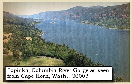
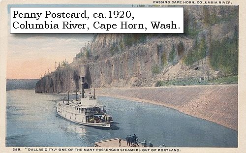
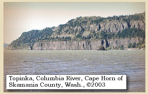
The Biddle/Allen version does not mention Cape Horn, however the first draft of Captain Clark's journal mentions the Cape Horn area as a "Stard. point of rocks on a high clift of black rocks"


Along the Journey - November 2, 1805
Cape Horn, Washington, 2003

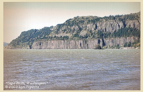
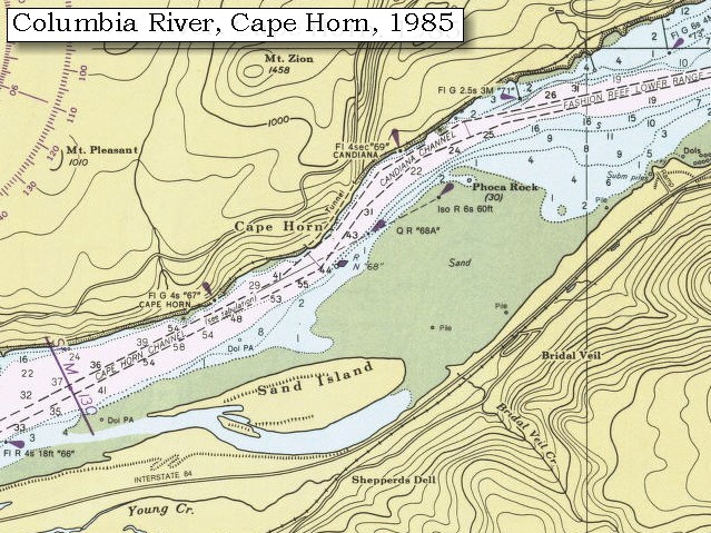
Cape Horn:
Flows of Grande Ronde Basalt of the Columbia River Basalt Group form the steep cliffs of Cape Horn, with Troutdale formation gravels capping the basalt unconformably. The gravels in turn are overlain by lavas of the small Mount Zion olivine basalt shield, of the Boring Lava Field. -- Norman and Roloff, 2004, Washington State DNR Open-File Report 2004-7.


Map, 1854, Columbia River, Fort Vancouver area, click to enlarge Map, 1911 USGS topo map of the Rooster Rock - Phoca Rock area, click to enlarge Map, 1985, Cape Horn and Phoca Rock, click to enlarge Image, 1867, Cape Horn near Celilo, click to enlarge Image, ca.1879-1909, Cape Horn, click to enlarge Stereo Image, 1867, Cape Horn, click to enlarge Stereo Image, 1867, Cape Horn from upstream, click to enlarge Penny Postcard, ca.1920, Steamer passing Cape Horn, click to enlarge Image, 2003, Cape Horn, Washington, as seen from Dalton Point, Oregon
  1. 1853-54 Map, Columbia River, including the Fort Vancouver area (section of original). (Click to enlarge). Includes Longview, Washington (Monticello), Coweeman River (Minter R.), Kalama River (Ca-la-ma R.), Lewis River (Cath-la-pootle R.), Willamette River, Fort Vancouver, Cape Horn, and "The Cascades". Vancouver Lake is depicted but not labeled. Original Map: "Rocky Mountains to Puget Sound : from explorations and surveys / made under the direction of the Hon. Jefferson Davis, Secretary of War by Isaac I. Stevens Governor of Washington Territory, 1853-4." Inset: (Supplementary sketch) Reconnaissance of the railroad route from Wallawalla to Seattle via Yak-e-mah River & Snoqualmie Pass. By A. W. Tinkham in January 1854. Drawn by J. R. P. Mechlin. 20 x 28 cm. Topographer, John Lambert, Published in Washington D.C., 1859, 1:1,200,000, Notes: From the U.S. War Department, Explorations and Surveys for a Railroad Route from the Mississippi River to the Pacific Ocean, Topographical Maps, to Illustrate the Various Reports, U.S. Library of Congress American Memories Reference "LC Railroad Maps #156". -- U.S. Library of Congress, American Memories Website, 2004
  2. 1911 Map (section of original), from Mount Hood and Vicinity 1:125,000 topographic quadrangle. (Click to enlarge). Cape Horn is on the Washington side of the Columbia, just below Mount Zion. Original map surveyed in 1907 and 1909-1911, contour interval of 100 feet. -- University of Washington Library Collections Website, 2002
  3. 1985 Map (section of original), Cape Horn and Phoca Rock. (Click to enlarge). Office of Coast Surveys, Historical Maps and Charts, Columbia River, Vancouver to Bonneville, 1985, Chart#18531, 1:40,000. -- NOAA Office of Coast Survey Website, 2004
  4. 1867, Cape Horn near Celilo. (Click to enlarge). "Cape Horn near Celilo, Columbia River", by Charleton E. Watkins, 1867. Oregon Historical Society #OrHi65695. -- Oregon Historical Society Archives Website, 2002
  5. ca.1879-1909, Cape Horn on the Columbia River. (Click to enlarge). Pictured is a scene in the region served by the Oregon Railway & Navigation Company between 1879 and 1909. Photograph Date: 1879-1909. Oregon State Archives, Salem Public Library Collections. -- Oregon State Archives Website, 2002
  6. 1867, Stereo view, Cape Horn. (Click to enlarge). Cape Horn from downstream. Caption on image: Cape Horn, Columbia River. Photographer: Carleton E. Watkins. Phototraph Date: 1867. University of Washington Sterocard Collection #STE028, Stereocard Collection No. 58. -- University of Washington Libraries Collection Website, 2003
  7. 1867, Stereo view, Cape Horn, from upstream. (Click to enlarge). Cape Horn from upstream, with boats in foreground. Caption on image: Cape Horn, Columbia River. Photographer: Carleton E. Watkins. Photograph Date: 1867. University of Washington Stereocard Collection #STE029, Stereocard Collection No. 58. -- University of Washington Libraries Collection Website, 2003
  8. ca.1920, Penny Postcard, Steamer passing Cape Horn. (Click to enlarge). The Steamer "Dallas City", one of the many steamers out of Portland, passes Cape Horn, Columbia River. #248, Chas. S. Lipschuetz Company, Portland, Oregon. Postmarked August, 1921. -- L.Topinka private collection, 2001, used with permission.
  9. 2003, Cape Horn, Washington, as seen from Dalton Point, Oregon. (Click to enlarge). Copyright © 2003 Lyn Topinka, private archives, used with permission.


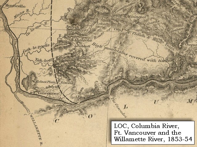
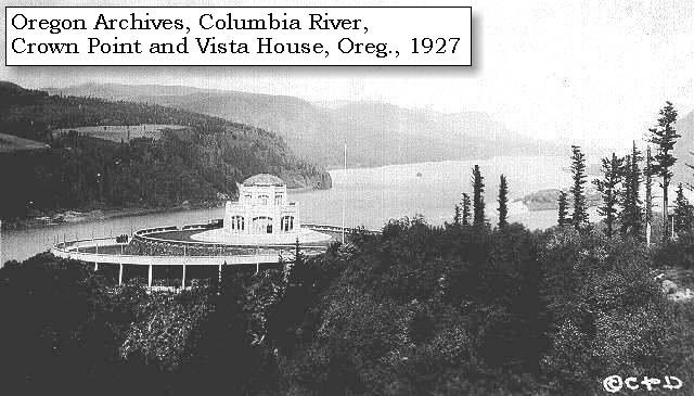
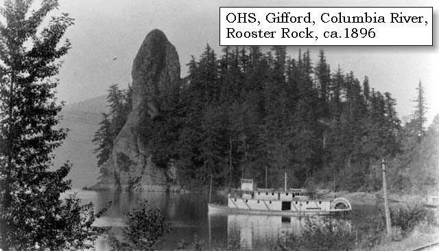
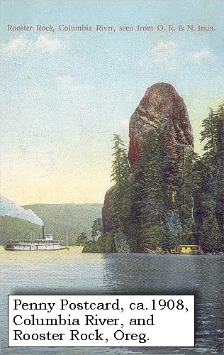
We continued six miles further, and halted for the night under a high projecting rock [Rooster Rock] on the left side of the river


Along the Journey - November 2, 1805
Rooster Rock, ca.1908

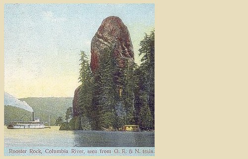
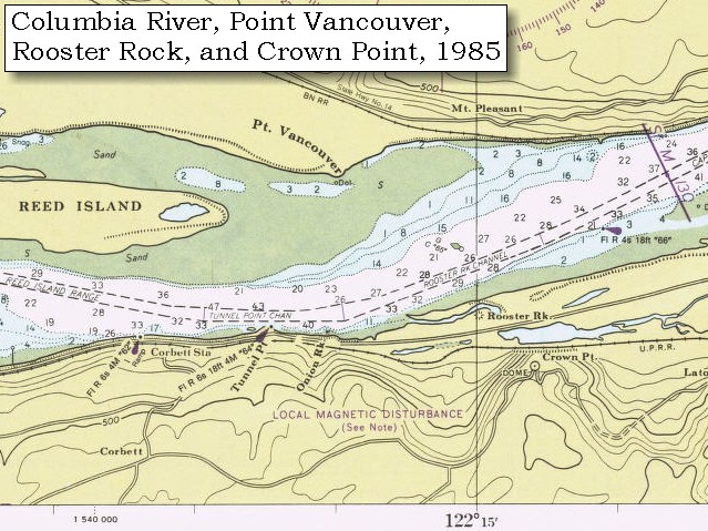
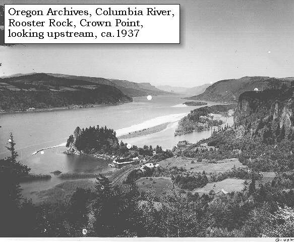
Rooster Rock and Rooster Rock State Park:
Rooster Rock is a landslide portion of a lava flow which filled an early ancestral canyon of the Columbia River thousands of years ago, at the location of today's Crown Point. The scar is still visible on the cliff above Rooster Rock. Rooster Rock State Park is located 22 miles east of Portland, Oregon, along Interstate 84. Enjoy three miles of sandy beaches and a swimming area. -- Norman and Roloff, 2004, Washingon State DNR Open-File Report 2004-7, and Oregon Parks and Recreation Website, 2002.


Map, 1911 USGS topo map of the Rooster Rock - Phoca Rock area, click to enlarge Map, 1985, Reed Island, Point Vancouver, Rooster Rock, and Crown Point, click to enlarge Image, ca.1896, Rooster Rock, click to enlarge Stereo Image, 1902, Rooster Rock, click to enlarge Penny Postcard, ca.1908, Rooster Rock and a Steamer, click to enlarge Image, 1937, Columbia River Gorge and Rooster Rock, click to enlarge
  1. 1911 Map (section of original), from Mount Hood and Vicinity 1:125,000 topographic quadrangle. (Click to enlarge). Original map surveyed in 1907 and 1909-1911, contour interval of 100 feet. Rooster Rock is just at the edge of the map on the left. -- University of Washington Library Collections Website, 2002
  2. 1985 Map (section of original), Reed Island, Point Vancouver, Rooster Rock, and Crown Point. (Click to enlarge). Office of Coast Surveys, Historical Maps and Charts, Columbia River, Vancouver to Bonneville, 1985, Chart#18531, 1:40,000. -- NOAA Office of Coast Survey Website, 2004
  3. ca.1896, Rooster Rock, Oregon. (Click to enlarge). "Hattie Belle" at Rooster Rock, by Benjamin Gifford, ca.1896. Oregon Historical Society Archives #OrHi9561. -- Oregon Historical Society Archives Website, 2002
  4. 1902, Stereo view, Rooster Rock. (Click to enlarge). "Rooster Rock, Curious rock formation along the Columbia River, Oregon, 1902, University of Washington Freshwater and Marine Image Bank Collection. -- University of Washington Libraries Collection Website, 2003
  5. ca.1908, Penny Postcard, Rooster Rock and Steamer. (Click to enlarge). "Rooster Rock, Columbia River, seen from O.R. & N. train." #4020, Published fot the J.K. Gill Co., Portland, Ore., by M. R., Los Angeles. Card has postmark of 1908. -- L.Topinka private collection, 2003, used with permission.
  6. ca.1937, Columbia River Gorge and Rooster Rock, Oregon. (Click to enlarge). The Columbia River Gorge, from Oregon looking east. Crown Point with the Vista House is on a rockly cliff visible on the right (Oregon side). On the left is Washington State. Rooster Rock is visible below (slightly lower left of center) as well as a marina built on the edge of a cove in the river. Photographer: Ralph Gifford. Photograph Date: ca.1937. Oregon State Archives, Oregon Department of Highways #0HDG402. -- Oregon State Archives Website, 2003


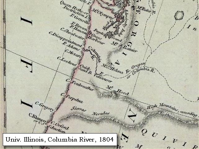
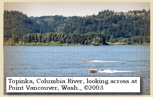
opposite the point of a large meadow [Point Vancouver].


Along the Journey - November 2, 1805
Point Vancouver, 2003

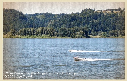
Point Vancouver:
Point Vancouver was named by Lieutenant William Broughton in 1792, and marks the furthest upstream on the Columbia River he explored. He named the point of land after his commander Captain George Vancouver. -- City of Washougal Website, 2003


Map, 1795, Pacific Northwest and the Columbia River, click to enlarge Map, 1798, Columbia River of George Vancouver, click to enlarge Map, 1804, Pacific Northwest and the Columbia River, click to enlarge Map, 1985, Reed Island, Point Vancouver, Rooster Rock, and Crown Point, click to enlarge Image, 2003, Point Vancouver, Washington
  1. 1795 Map, Pacific Northwest and the Columbia River (section of original). (Click to enlarge). Includes the Columbia River ("River Oregan"), Mount Rainier, Mount St. Helens, and Mount Hood, and Point Vancouver. Original Map: A map exhibiting all the new discoveries in the interior parts of North America / inscribed by permission to the honorable governor and company of adventurers of England trading into Hudsons Bay in testimony of their liberal communications to their most obedient and very humble servant A. Arrowsmith, January 1st 1795. Published: London, 1802. Notes: Relief shown by hachures. Shows "Rivers added east of the Rocky Mountains, 900 L. 450 Lat.," from Tooley's Printed maps of America. In lower margin: London: Published Jan. 1, 1795 by A. Arrowsmith, No. 24 Rathbone Place. Includes notes. Reference: Tooley. Printed maps of America 137. Scale [ca. 1:3,800,000] (W 1600--W 400/N 700--N 250). Library of Congress American Memory Archives #G3300 1802 A7 Vault Casetop. -- U.S. Library of Congress Archives, 2004, "American Memory"
  2. 1798 Map, Columbia River of George Vancouver (section of original). (Click to enlarge). Includes Columbia River, Cape Disappointment, Point Adams, Point Vancouver, and Mount St. Helens. Original Map: George Vancouver's "A Chart Shewing Part of the Coast of N.W. America." In A Voyage of discovery to the North Pacific ocean, and Round the World. London, 1798. University of Virginia Special Collection "Lewis & Clark, The Maps of Exploration 1507-1814". -- University of Virginia Library Archives Website, 2004
  3. 1804 Map, Pacific Northwest and the Columbia River (section of original). (Click to enlarge). Shows Point Vancouver ("P.Vancouver"). Includes the Columbia River, Mount Baker, Mount Rainier, Mount St. Helens, and Mount Hood. Original Map: "North America". Year: 1804. Author: Robert Wilkinson and E. Bourne. Notes: Scale, ca. 1:9,000,000; London, R. Wilkinson, 12th of Aug. 1804; 1 map, hand col.; 51 x 61 cm.; Relief shown by hachures; Prime meridians: Greenwich, Ferro. -- Henry Stevens and Roland Tree, Comparative cartography, exemplified in an analytical & bibliographical description of nearly one hundred maps and charts of the American continent published in Great Britain during the years 1600 to 1850, no. 62a. In the Collection of Map & Geography Library, University of Illinois at Urbana-Champaign, Champaign, Illinois, Call Number: G3300 1804 .W5. -- Univerisity of Illinois at Urbana-Champaign Website, 2004.
  4. 1985 Map (section of original), Reed Island, Point Vancouver, Rooster Rock, and Crown Point. (Click to enlarge). Office of Coast Surveys, Historical Maps and Charts, Columbia River, Vancouver to Bonneville, 1985, Chart#18531, 1:40,000. -- NOAA Office of Coast Survey Website, 2004
  5. 2003, Looking at Point Vancouver, Washington, from Interstate 84, Oregon. (Click to enlarge). Copyright © 2003 Lyn Topinka, private archives, used with permission.


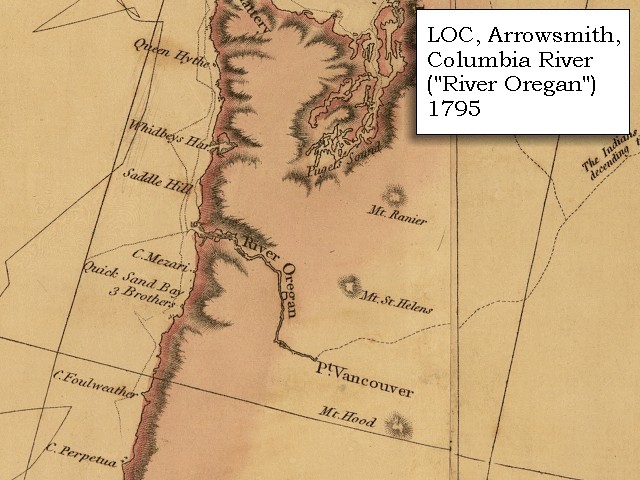
The mountains, which from the great shoot to this place are high, rugged, and thickly covered with timber chiefly of the pine species, here leave the river on each side; the river becomes two and a half miles in width, and the low grounds are extensive and well supplied with wood. The Indians whom we left at the portage passed us, on their way down the river, and seven others who were descending in a canoe for the purpose of trading below, encamped with us. We had made from the foot of the great shoot twenty-nine miles today. The ebbtide rose at our camp about nine inches, the flood must rise much higher. We saw great numbers of water-fowl, such as swan, geese, ducks of various kinds, gulls, plover, and the white and gray brant, of which last we killed eighteen.
"... we encamped under a high projecting rock on the Lard. Side, here the mountains leave the river on each Side, which from the great Shute to this place is high and rugid; thickly covered with timber principalley of the Pine Species. The bottoms below appear extensive and thickly covered with wood. river here about 2 1/2 miles wide. ..." [Clark, November 2, 1805]


Along the Journey - November 2, 1805
The Camp - November 2, 1805:
Lewis and Clark's camp of November 2, 1805, was on the Oregon side of the Columbia River near Rooster Rock.


Home Previous Continue


If you have questions or comments please contact: GS-CVO-WEB@usgs.gov
June/July 2004, Lyn Topinka
The Volcanoes of Lewis and Clark Home Page | CVO Home Page