The Volcanoes of
Lewis and Clark
Lewis and Clark
|
December 7 - 25, 1805 A Place to Winter - Tongue Point to Fort Clatsop |
|
Home
The Volcanoes of Lewis and Clark Map of the Journey Volcanoes, Basalt Plateaus, Major Rivers, etc. The Volcanoes Mount Adams, Mount Hood, Mount Jefferson, Mount Rainier, and Mount St. Helens CALENDAR of the Journey October 1805 to June 1806 Along the Journey Pacific Northwest Maps - Columbia River, Volcanoes, Flood Basalts, Missoula Floods, Geology, etc. The Corps of Discovery The Journey of Lewis and Clark About the Reference Materials The Journals, Biddle/Allen, DeVoto, Gass, Moulton, Topo Maps, and others USGS Lewis and Clark Links Links to USGS Websites highlighting the Lewis and Clark Journey Resources Publications Referenced and Websites Visited |
PREVIOUS
December 1-6 Looking for a Place to Winter, At Tongue Point |
December 7-25
A Place to Winter Tongue Point to Fort Clatsop Tongue Point, Smith Point and Astoria, Youngs Bay, Youngs River, Lewis and Clark River, Mount St. Helens and Mount Adams, and Fort Clatsop |
CONTINUE
March 23-24, 1806 Heading Home, Fort Clatsop to Tenasillahe Island |
|
At the Pacific - December 1805
A Place to Winter - Tongue Point to Fort Clatsop |
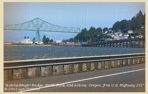
| Lewis and Clark's camp of November 27 through December 6, 1805, was on the west side of Tongue Point, just east of present-day Astoria, Oregon. The majority of the party under Captain Clark remained there until December 7, 1805, while Captain Lewis and five men scouted for a suitable winter camp. On December 7, 1805, the entire group left for the location of their winter camp. |
| Saturday, December 7, 1805 |
| [The morning] was fair; we therefore loaded our canoes, and proceeded [leaving Tongue Point for the Fort Clatsop area where the expedition would winter over]. But the tide was against us, and the waves very high, so that we were obliged to proceed slowly and cautiously. We at length turned a point [Smith Point, location of today's city of Astoria], |
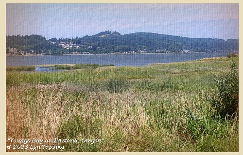
| and found ourselves in a deep bay [Youngs Bay]; here we landed for breakfast, and were joined by the party sent out three days ago to look for the six elk. In seeking for the elk they had missed their way for a day and a half, and when they reached the place, found the elk so much spoiled that they brought the skins only of four of them. |
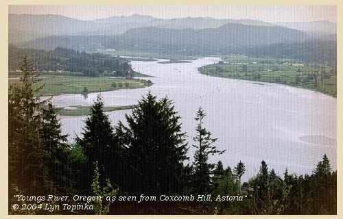
| After breakfast we coasted round the bay [Youngs Bay], which is about four miles across, and receives, besides several small creeks, two rivers called by the Indians, the one Kilhowanakel [Youngs River], |
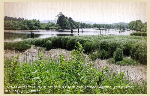
| the other Netul [Lewis and Clark River]. |
| We called it Meriwether's bay [Youngs Bay], from the christian name of captain Lewis, who was no doubt the first white man who surveyed it. As we went along the wind was high from the northeast, and in the middle of the day it rained for two hours, and then cleared off. On reaching the south side of the bay, we ascended the Netul [Lewis and Clark River] for three miles to the first point of highland on its western bank, and formed our camp [near the later site of Fort Clatsop, where Lewis and Clark wintered over] in a thick grove of lofty pines, about two hundred yards from the water, and thirty feet above the level of the high tides. |
|
"...
Some rain from 10 to 12 last night this morning fair, we Set out at 8
oClock down to the place Capt Lewis pitched on for winter quarters ...
To point Adams is West To pt Disapointment N.75 W. They informed me that they found the Elk after being lost in the woods for one Day and part of another. ... we stopd & Dined in the commencement of a bay, after which proceeded on around the bay to S E & assended a creek 8 miles to ahigh pt. & camped haveing passed arm makeing up to our left into the countrey 'Mt. St. Helens' is the mountain we mistook for 'Mt. Reeaneer' receved 2 Small Brooks on the East, extencive marshes at this place of Encampment We propose to build & pass the winter The situation is in the Center of as we conceve a hunting Countrey. This day is fair except about 12 oClock at which time Some rain and a hard wind imedeately after we passed the point from the N. E which Continued for a about 2 hours and Cleared up ..." [Clark, December 7, 1805, first draft] |
|
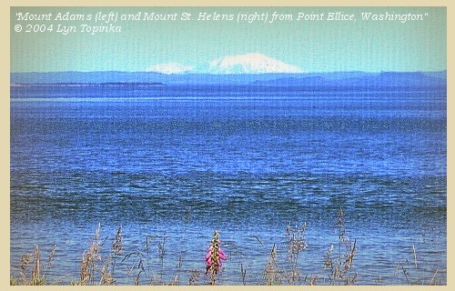
On November 25 the Lewis and Clark identified a peak they saw at the mouth of the Columbia as Mount Rainier, when it was really Mount St. Helens. What they didn't comment on was in certain areas near the mouth of the Columbia River, Mount Adams can also be seen.
|
| "... Some rain from 10 to 12 last night, this morning fair, have every thing put on board the Canoes and Set out to the place Capt Lewis had viewed and thought well Situated for winter quarters -- we proceeded on against the tide to a point about [blank] miles ... we proceeded on around the point into the bay and landed to take brackfast ... then proceeded around this Bay which I have taken the liberty of calling Meriwethers Bay the Cristian name of Capt. Lewis who no doubt was the 1st white man who ever Surveyed this Bay, we assended a river which falls in on the South Side of this Bay 3 miles to the first point of high land on the West Side, the place Capt. Lewis had viewed and formed in a thick groth of poine about 200 yards from the river, this situation is on a rise about 30 feet higher than the high tides leavel and thickly Covered with lofty poine. this is certainly the most eligable Situation for our purposes of any in its neighbourhood. ... Meriwethers Bay is about 4 miles across deep & receves 2 rivers the 'Kil how-a-nah-kle' and the 'Ne tul' and Several Small Creeks. we had a hard wind from the N. E. and Some rain about 12 oClock to day wich lasted 2 hours and Cleared away. From the Point above Meriwethers Bay to Point Adams is 'West' to point Disapointment is N. 75o W. -- ..." [Clark, December 7, 1805] |
|
|
|
The Camp - December 7, 1805
Near the later site of Fort Clatsop, where Lewis and Clark wintered over. |
| The Winter Months - Fort Clatsop |
| December 25, 1805 |
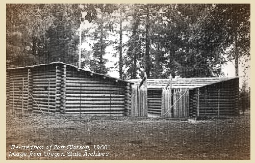
| "... rainy & wet. disagreeable weather. we all moved in to our new Fort, which our officers name Fort Clatsop after the name of the Clatsop nation of Indians who live nearest to us. the party Saluted our officers by each man firing a gun at their quarters at day break this morning. they divided out the last of their tobacco among the men that used and the rest they gave each a Silk hankerchief, as a Christmast gift, to keep us in remembrence of it as we have no ardent Spirits, but are all in good health which we esteem more than all the ardent Spirits in the world. we have nothing to eat but poor Elk meat and no Salt to Season that with, but Still keep in good Spirits as we expect this to be the last winter that we will have to pass in this way. ..." [Ordway, December 25, 1805] |
| "... We had hard rain & Cloudy weather as usual. We all moved into our new Garrison or Fort, which our Officers named after a nation of Indians who resided near us, called the Clatsop Nation; Fort Clatsop. We found our huts comfortable, excepting smoaking a little. ..." [Whitehouse, December 25, 1805] |
| Home | Previous | Continue |
If you have questions or comments please contact: GS-CVO-WEB@usgs.gov
June/July 2004, Lyn Topinka
The Volcanoes of Lewis and Clark Home Page | CVO Home Page


