The Volcanoes of
Lewis and Clark
November 26 - 30, 1805
Looking for a Place to Winter - Pillar Rock to Tongue Point
 
Home
The Volcanoes of Lewis and Clark

Map of the Journey
Volcanoes, Basalt Plateaus, Major Rivers, etc.

The Volcanoes
Mount Adams, Mount Hood, Mount Jefferson, Mount Rainier, and Mount St. Helens

CALENDAR of the Journey
October 1805 to June 1806

Along the Journey
Pacific Northwest Maps - Columbia River, Volcanoes, Flood Basalts, Missoula Floods, Geology, etc.

The Corps of Discovery
The Journey of Lewis and Clark

About the Reference Materials
The Journals, Biddle/Allen, DeVoto, Gass, Moulton, Topo Maps, and others

USGS Lewis and Clark Links
Links to USGS Websites highlighting the Lewis and Clark Journey

Resources
Publications Referenced and Websites Visited


PREVIOUS

November 25
Looking for a Place to Winter, Station Camp to Pillar Rock
November 26-30

Looking for a Place to Winter
Pillar Rock to Tongue Point

Pillar Rock, Cathlamet Point - Aldrich Point, Cathlamet Bay and the Lewis and Clark NWR, Cathlamet Bay, Settler Point, and the Twilight Eagle Sanctuary, John Day River (Clatsop County), Tongue Point, Pebbles of Various Colors, Smith Point and Astoria, and Youngs Bay
CONTINUE

December 1-6
Looking for a Place to Winter - At Tongue Point
 

On October 7, 1805, Lewis and Clark and the "Corps of Discovery" began their journey down the Clearwater River and into the volcanics of the Pacific Northwest. The Corps travelled from the Clearwater to the Snake and down the "Great Columbia", finally reaching the Pacific Ocean on November 15, 1805. Along the journey they encountered the lava flows of the Columbia Plateau, river channels carved by the great "Missoula Floods", and the awesome beauty of five Cascade Range volcanoes.

Map, Lewis and Clark in the Pacific Northwest, click for brief
                         summary
[Click map for brief summary about the area]


At the Pacific - November 1805
Looking for a Place to Winter - Pillar Rock to Tongue Point
 

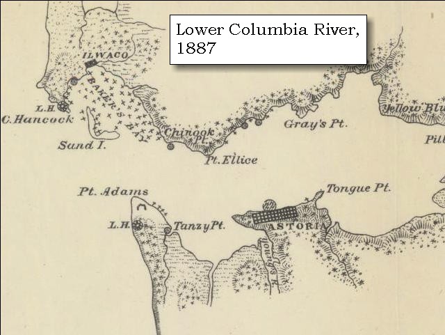
Lewis and Clark's camp of November 25, 1805, was near Pillar Rock, Washington, close to their camp of November 7, 1805.

Tuesday, November 26, 1805
in the morning. it rained. We set out with the wind from east northeast, and a short distance above the rock [Pillar Rock], near our camp, began to cross the river.


Along the Journey - November 26, 1805
Pillar Rock, ca.1910

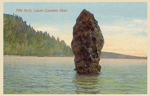
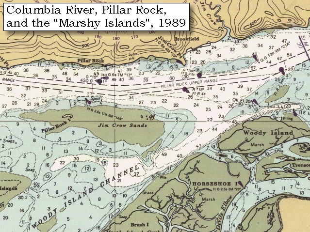
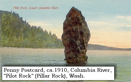
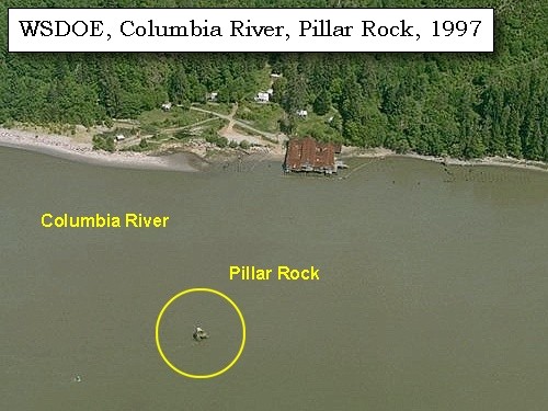
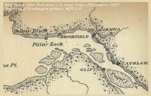
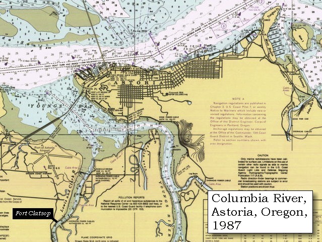
Pillar Rock:
Pillar Rock is a 70-foot high basaltic column sitting in water approximately 50 feet deep near the northern shore of the Columbia River. Simply marked "Rock" on Clark's route map, the basalt rock rose 75 to 100 feet above water level, depending on the tide. The landmark was given its present name by Broughton in 1792, and put on the map as "Pillar Rock" by Wilkes in 1841. Currently there is a navigation beacon located on top of Pillar Rock. -- U.S. National Park Service, Jefferson National Expansion Memorial Website, 2002, Pacific County Friends of Lewis and Clark Website, 2002, and Washington State Historical Society Website, 2002, "Lasting Legacy".


Map, 1887, Pillar Rock vicinity, click to enlarge Map, 1989, Pillar Rock and Jim Crow Point, click to enlarge NASA Image, 2001, Mouth of the Columbia River, click to enlarge Penny Postcard, ca.1910, Pillar Rock, click to enlarge Image, 1997, Pillar Rock, click to enlarge Image, 1997, Jim Crow Point, click to enlarge
  1. 1887 Map, Columbia River and the Pillar Rock vicinity (section of original). (Click to enlarge). Original Map: The Columbia River from Celilo to the mouth showing locations of the salmon fisheries, 1887. Scale ca. 1:375,000, Relief shown by hachures. U.S. Army Corps of Engineers, Engineer Office, G.P.O. 1888. University of Washington Archives #UW128. -- University of Washington Library Archives Website, 2002
  2. 1989 Map, Pillar Rock and Jim Crow Point (section of original). (Click to enlarge). Office of Coast Surveys, Historical Maps and Charts, Columbia River, Harrington Point to Crims Island, 1989, Chart#18523, 1:40,000. -- NOAA Office of Coast Survey Website, 2004
  3. 2001, NASA Image, Mouth of the Columbia River, including the location of Fort Clatsop. (Click to enlarge). NASA Space Shuttle photograph of the mouth of the Columbia River, including the location of Fort Clatsop, the Lewis and Clark National Wildlife Refuge, Tenasillahe Island, Puget Island, and Crim's Island, June 20, 2001. NASA Astronaut Photography of Earth #SS002-724-30. -- NASA Astronaut Photography of Earth Website, 2002
  4. ca.1910, Penny Postcard, Pillar Rock. (Click to enlarge). Caption reads "Pilot Rock", Lower Columbia River. "Pilot Rock" is also known as "Pillar Rock". Published by the Portland Post Card Co. Date: ca.1907-1915. -- L.Topinka private collection, 2003, used with permission
  5. 1997, Aerial view, Pillar Rock. (Click to enlarge). Washington State Department of Ecology Shorelines Aerial Photo #WAH0033, May 13, 1997. -- Washington State Department of Ecology Website, 2002
  6. 1997, Aerial view, Jim Crow Point. (Click to enlarge). Washington State Department of Ecology Shorelines Aerial Photo #WAH0038, May 13, 1997. -- Washington State Department of Ecology Website, 2002


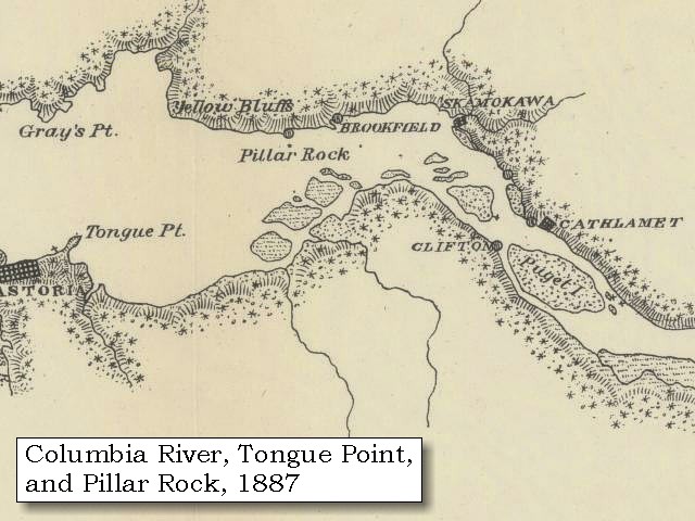
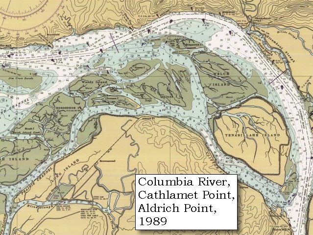
We passed between some low, marshy islands, which we called the Seal islands [today this area is the Lewis and Clark National Wildlife Refuge, see Cathlamet Bay entry below], and reached the south side of the Columbia at a bottom three miles below a point, to which we gave the name of point Samuel [Cathlamet Point - Aldrich Point].
"... Cloudy and Some rain this morning from 6 oClock. wind from the E. N. E, we Set out out early and crossed a Short distance above the rock out in the river, & between Some low marshey Islands to the South Side of the Columbia at a low bottom about 3 miles below Point 'Samuel' and proceeded near the South Side leaveing the Seal Islands to our right and a marshey bottom to the left ..." [Clark, November 26, 1805]


Along the Journey - November 26, 1805
Map, Pillar Rock area, 1887

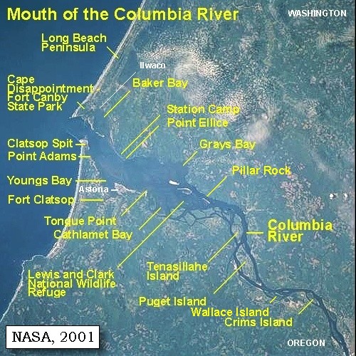
Cathlamet Point - Aldrich Point:
Aldrich Point, Oregon, has had many names, from Lewis and Clark's "Point Samuel", to early settlers' "Cathlamet Point", and today's "Adrich Point". It is located downstream of Puget Island and Tenasillahe Island as the Columbia bends to the left.


Map, 1814, Lewis and Clark on the Columbia, click to enlarge Map, 1887, Pillar Rock vicinity, click to enlarge Map, 1989, Aldrich Point, click to enlarge
  1. 1814 Map, Lewis and Clark's map of the Columbia River (section of original). (Click to enlarge.) Cathlamet Point is depicted but not named (where depicted high ground on south side of the river ends). Map includes three of the five volcanoes Lewis and Clark saw and commented on. While the journals mention the expedition seeing Mount Adams, it does not appear on their map. Mount Jefferson is to the south (bottom) and off the map. From the "Nicholas Biddle/Paul Allen" 1814 publication. Original Map: "A Map of Lewis and Clark's Track, Across the Western Portion of North America, From the Mississippi to the Pacific Ocean". From: History of the expedition under the command of Captains Lewis and Clark : to the sources of the Missouri, thence across the Rocky Mountains and down the river Columbia to the Pacific Ocean : performed during the years 1804-5-6 : by order of the government of the United States / prepared for the press by Paul Allen. Philadelphia : Bradford and Insskeep, 1814. Harold B. Lee Library, Brigham Young University #upbover maps37. -- Brigham Young University, Harold B. Lee Library Website, 2004.
  2. 1887 Map (section of original), Columbia River and the Pillar Rock vicinity. (Click to enlarge). Cathlamet Point (Aldrich Point) is unnamed on the map, but is the point opposite and upstream of Pillar Rock. Original Map: The Columbia River from Celilo to the mouth showing locations of the salmon fisheries, 1887. Scale ca. 1:375,000, Relief shown by hachures. U.S. Army Corps of Engineers, Engineer Office, G.P.O. 1888. University of Washington Archives #UW128. -- University of Washington Library Archives Website, 2002
  3. 1989 Map, Aldrich Point (section of original). (Click to enlarge). Office of Coast Surveys, Historical Maps and Charts, Columbia River, Harrington Point to Crims Island, 1989, Chart#18523, 1:40,000. -- NOAA Office of Coast Survey Website, 2004


After going along the shore for five miles, we entered a channel two hundred yards in width, which separates from the main land a large, but low island [one of the marshy islands in the Lewis and Clark National Wildlife Refuge]. On this channel, and at the foot of some highlands, is a village, where we landed [near today's town of Knappa, Oregon]. It consists of nine large wooden houses, inhabited by a tribe called Cathlamahs, who seem to differ neither in dress, language, nor manners, from the Chinnooks and Wahkiacums: like whom they live chiefly on fish and wappatoo roots. We found, however, as we hoped, some elk meat: after dining on some fresh fish and roots, which we purchased from them at an immoderate price, we coasted along a deep bend of the river towards the south [Lewis and Clark are entering Cathlamet Bay, today part of the Lewis and Clark National Wildlife Refuge.],


Along the Journey - November 26, 1805
Cathlamet Bay, 2004

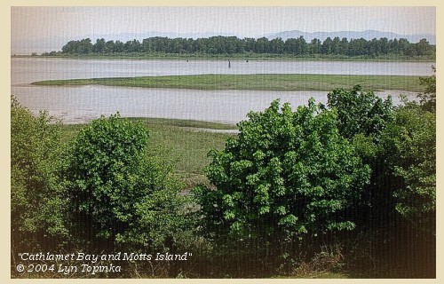
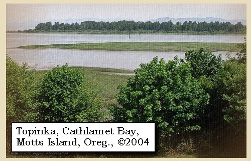
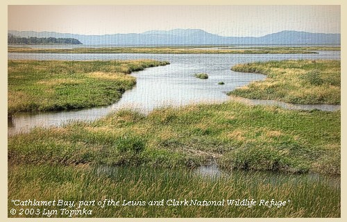
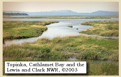
Cathlamet Bay and the Lewis and Clark National Wildlife Refuge:
Cathlamet Bay is east of Astoria, Oregon and Tongue Point, Oregon, and south of the main ship channel of the Columbia River, and is part of the broad Columbia River Estuary. There are many islands which are covered with tule in the summer, but in the winter they are almost indiscernible. Cathlamet Bay is part of the Lewis and Clark National Wildlife Refuge, established in 1972 to preserve the estuary land and water as vital fish and wildlife habitat. The refuge includes 35,000 acres of islands, bars, mud flats and tidal marshes. The refuge is the largest marsh in western Oregon and provides habitat for peak populations of 3,000 tundra swans, 2,000 Canada geese and 5,000 ducks in February and March each year as they gather here before the northward migration. Woody, Horseshoe, Karlson, and Marsh islands are the main islands in the wildlife refuge on Oregon's side of the Columbia. In 1805, on their trip to the Pacific Ocean, Lewis and Clark referred to these islands simply as "marshy islands". On their return in 1806, they called this area "Seal Islands". -- U.S. Fish and Wildlife Service Website, 2003, Lewis and Clark Bicentennial in Oregon Website, 2002, NOAA Office of Coast Survey Website, 2003 and Washington State Historical Society Website, 2002


Map, 1814, Lewis and Clark on the Columbia, click to enlarge Map, 1855, Northwest Oregon and mouth Columbia River, click to enlarge Map, 1887, Map, 1987, Tongue Point and western part of Cathlamet Bay, click to enlarge NASA Image, 2001, Mouth of the Columbia River, click to enlarge Image, 2004, Cathlamet Bay, part of the Lewis and Clark NWR
  1. 1814 Map, Lewis and Clark's map of the Columbia River (section of original). (Click to enlarge.) Cathlamet Bay (full of islands) is depicted but not named. The John Day River is shown (also depicted but not named) emptying into Cathlamet Bay. Map includes three of the five volcanoes Lewis and Clark saw and commented on. While the journals mention the expedition seeing Mount Adams, it does not appear on their map. Mount Jefferson is to the south (bottom) and off the map. From the "Nicholas Biddle/Paul Allen" 1814 publication. Original Map: "A Map of Lewis and Clark's Track, Across the Western Portion of North America, From the Mississippi to the Pacific Ocean". From: History of the expedition under the command of Captains Lewis and Clark : to the sources of the Missouri, thence across the Rocky Mountains and down the river Columbia to the Pacific Ocean : performed during the years 1804-5-6 : by order of the government of the United States / prepared for the press by Paul Allen. Philadelphia : Bradford and Insskeep, 1814. Harold B. Lee Library, Brigham Young University #upbover maps37. -- Brigham Young University, Harold B. Lee Library Website, 2004.
  2. 1855 Map, Northwest Oregon and mouth of the Columbia River (section of original). (Click to enlarge). The "Marshy" or "Seal Islands" are depicted but not named (many islands left of tape). Includes the Columbia River, Cape Disappointment, Point Adams, Saddle Mountain, Lewis and Clark River, Youngs River. Original Map: From the northern boundary of California to the Columbia River : from explorations and surveys / made under the direction of Hon. Jefferson Davis, Sec. of War by Lieut. R. S. Williamson, U.S. Topl. Engrs. and Lieut. H. L. Abbot, U.S. Topl. Engrs., H. C. Fillebrown, J. Young, and C. D. Anderson, Assts., 1855. Notes: Scale 1:760,320. Relief shown by hachures. At head of title: Routes in Oregon and California. Map no. 2. "Drawn by John Young." From U.S. War Department, Explorations and Surveys for a Railroad Route from the Mississippi River to the Pacific Ocean. Topographical Maps... to Illustrate the Various Reports... (Washington, 1859) Library of Congress American Memory Archives #G4290 1855 .W5 RR 170. -- U.S. Library of Congress Archives, 2004, "American Memory"
  3. 1887 Map (section of original), Columbia River and the "Seal Islands" vicinity. (Click to enlarge). Cathlamet Bay, the bay east (right) of Tongue Point, is unnamed on the map. Original Map: The Columbia River from Celilo to the mouth showing locations of the salmon fisheries, 1887. Scale ca. 1:375,000, Relief shown by hachures. U.S. Army Corps of Engineers, Engineer Office, G.P.O. 1888. University of Washington Archives #UW128. -- University of Washington Library Archives Website, 2002
  4. 1987 Map, Tongue Point and western part of Cathlamet Bay (section of original). (Click to enlarge). Office of Coast Surveys, Historical Maps and Charts, Columbia River, Pacific Ocean to Harrington Point, 1987, Chart#18521, 1:40,000. -- NOAA Office of Coast Survey Website, 2004
  5. 2001, NASA Image, Mouth of the Columbia River, including the location of Fort Clatsop. (Click to enlarge). NASA Space Shuttle photograph of the mouth of the Columbia River, including the location of Fort Clatsop, the Lewis and Clark National Wildlife Refuge, Tenasillahe Island, Puget Island, and Crim's Island, June 20, 2001. NASA Astronaut Photography of Earth #SS002-724-30. -- NASA Astronaut Photography of Earth Website, 2002
  6. 2003, Cathlamet Bay, Oregon, part of the Lewis and Clark National Wildlife Refuge. (Click to enlarge). Copyright © 2003 Lyn Topinka, private archives, used with permission.


and at night encamped under a high hill [along the South Channel of Cathlamet Bay, downstream of Settler Point, in area of today's Twilight Eagle Sanctuary]; all the way from the village the land is high, and has a thick growth of pine balsam, and other timber; but as it was still raining very hard, it was with difficulty we procured wood enough to make fires. Soon after we landed, three Indians from the Cathlawah village came down with wappatoo roots, some of which we purchased with fish-hooks.


Along the Journey - November 26, 1805
Cathlamet Bay and the Twilight Eagle Sanctuary, 2003

Cathlamet Bay, Settler Point, and the Twilight Eagle Sanctuary:
The Twilight Eagle Sanctuary is located off of Highway 30 between Astoria and Svensen, Oregon. The Sanctuary is an excellent place to observe the large variety of birds that use the lower Columbia River estuary. Not only are eagles found in the area, but waterfowl, shorebirds, and songbirds associated with wetlands abound. There is a great viewing platform located along the river that allow for some excellent viewing opportunities. -- Oregon Department of Fish and Wildlife Website, 2004


Map, 1890, Cathlamet Bay and Settler Point, click to enlarge Map, 1987, Cathlamet Bay and Settler Point, click to enlarge NASA Image, 2001, Mouth of the Columbia River, click to enlarge Image, 2003, Cathlamet Bay, part of the Lewis and Clark NWR
  1. 1890 Map (section of original), Cathlamet Bay and Settler Point. (Click to enlarge). Office of Coast Surveys, Historical Maps and Charts, Columbia River, Columbia River, Sheet No.2, 1890, Chart #6141, Plate No.1454, 1:40,000. -- NOAA Office of Coast Survey Website, 2004
  2. 1987 Map, Cathlamet Bay, John Day River, and Settler Point (section of original). (Click to enlarge). Office of Coast Surveys, Historical Maps and Charts, Columbia River, Pacific Ocean to Harrington Point, 1987, Chart#18521, 1:40,000. -- NOAA Office of Coast Survey Website, 2004
  3. 2001, NASA Image, Mouth of the Columbia River, including the location of Fort Clatsop. (Click to enlarge). NASA Space Shuttle photograph of the mouth of the Columbia River, including the location of Fort Clatsop, the Lewis and Clark National Wildlife Refuge, Tenasillahe Island, Puget Island, and Crim's Island, June 20, 2001. NASA Astronaut Photography of Earth #SS002-724-30. -- NASA Astronaut Photography of Earth Website, 2002
  4. 2003, Cathlamet Bay, Oregon, and part of the Twilight Eagle Sanctuary and the Lewis and Clark National Wildlife Refuge. (Click to enlarge). Copyright © 2003 Lyn Topinka, private archives, used with permission.


Along the Journey - November 26, 1805
The Camp - November 26, 1805
Lewis and Clark's camp of November 26, 1805, was on the southern bank of the South Channel of Cathlamet Bay (Oregon side), downstream of Settlers Point and upstream of a small creek. Perhaps the area of today's Eskaline Creek. Today this is the location of the Twilight Eagle Sanctuary.


Wednesday, November 27, 1805
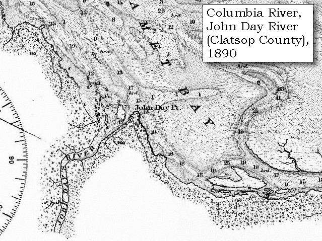
At daylight the next morning ... We went on in the rain, which had continued through the night, and passing between a number of islands [following the shoreline of Cathlamet Bay] came to a small river, called by the Indians Kekemahke [John Day River, Clatsop County].


Along the Journey - November 27, 1805
Map, John Day River (Clatsop County), 1890

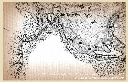
John Day River, Clatsop County, Oregon:
Lewis and Clark refered to Clastsop County's John Day River as "Ke-ke mar que Creek", a word obtained from the local indians. They did not comprehend that Pacific Northwest Indians did not name geographical features such as rivers and creeks; instead, they identified sites on the drainages. This concept was also foreign to later cartographers. Their translations of native languages led to many misconceptions of actual Indian meanings and names. This western Oregon river, like the one in eastern Oregon, was named for John Day of Wilson Price Hunt's Astorian overland expedition, 1811-12. -- Washington State Historical Society Website, 2002


Map, 1814, Lewis and Clark on the Columbia, click to enlarge Map, 1887, Columbia River from mouth to Pillar Rock, click to enlarge Map, 1890, John Day River and John Day Point, click to enlarge Map, 1987, Tongue Point, John Day River, western part of Cathlamet Bay, click to enlarge
  1. 1814 Map, Lewis and Clark's map of the Columbia River (section of original). (Click to enlarge.) The John Day River is depicted but not named. Map includes three of the five volcanoes Lewis and Clark saw and commented on. While the journals mention the expedition seeing Mount Adams, it does not appear on their map. Mount Jefferson is to the south (bottom) and off the map. From the "Nicholas Biddle/Paul Allen" 1814 publication. Original Map: "A Map of Lewis and Clark's Track, Across the Western Portion of North America, From the Mississippi to the Pacific Ocean". From: History of the expedition under the command of Captains Lewis and Clark : to the sources of the Missouri, thence across the Rocky Mountains and down the river Columbia to the Pacific Ocean : performed during the years 1804-5-6 : by order of the government of the United States / prepared for the press by Paul Allen. Philadelphia : Bradford and Insskeep, 1814. Harold B. Lee Library, Brigham Young University #upbover maps37. -- Brigham Young University, Harold B. Lee Library Website, 2004.
  2. 1887 Map, Columbia River from the Mouth to Pillar Rock (section of original). (Click to enlarge). The John Day River is depicted just right of Tongue Point, but not named. Original Map: The Columbia River from Celilo to the mouth showing locations of the salmon fisheries, 1887. Scale ca. 1:375,000, Relief shown by hachures. U.S. Army Corps of Engineers, Engineer Office, G.P.O. 1888. University of Washington Archives #UW128. -- University of Washington Library Archives Website, 2004
  3. 1890 Map (section of original), John Day River and John Day Point. (Click to enlarge). Office of Coast Surveys, Historical Maps and Charts, Columbia River, Columbia River, Sheet No.2, 1890, Chart #6141, Plate No.1454, 1:40,000. -- NOAA Office of Coast Survey Website, 2004
  4. 1987 Map, Tongue Point, John Day River, and the western part of Cathlamet Bay (section of original). (Click to enlarge). Office of Coast Surveys, Historical Maps and Charts, Columbia River, Pacific Ocean to Harrington Point, 1987, Chart#18521, 1:40,000. -- NOAA Office of Coast Survey Website, 2004


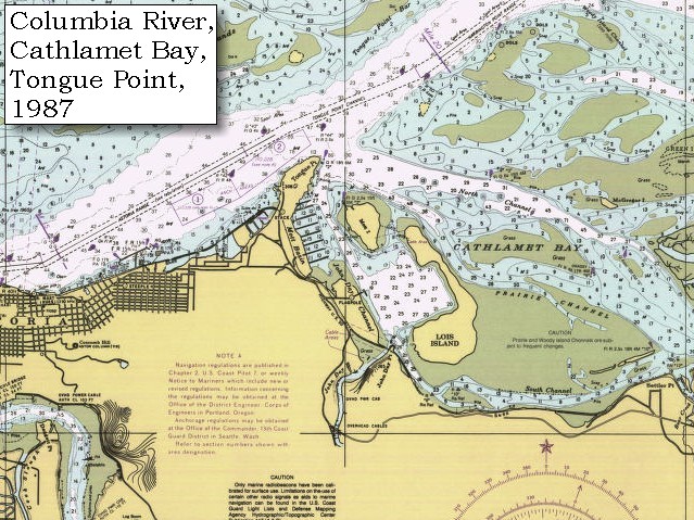
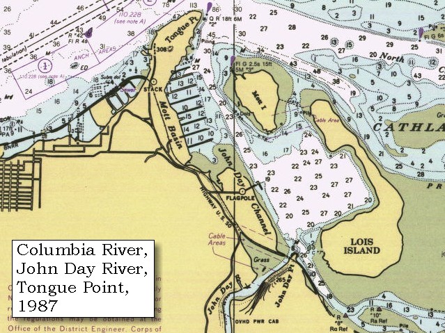
We afterwards came to a very remarkable knob of land [Tongue Point], projecting about a mile and a half towards Shallow bay [Grays Bay, on the Washington side of the Columbia], and about four miles round, while the neck of land which connects it to the main shore is not more than fifty yards wide. We went round this projection, which we named point William [Tongue Point];


Along the Journey - November 27, 1805
Tongue Point, 2003

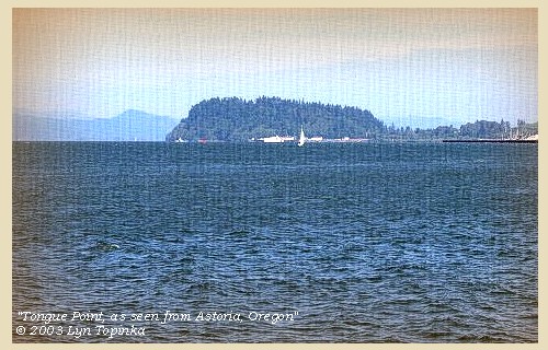
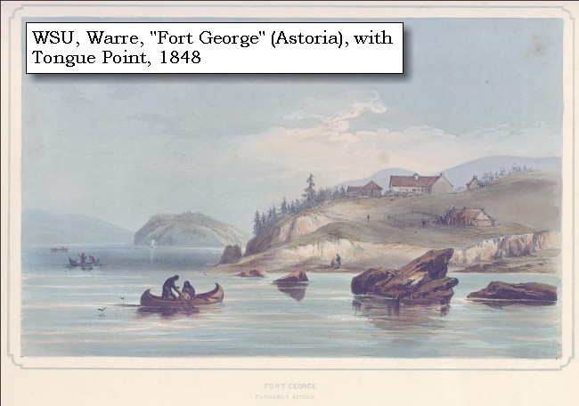
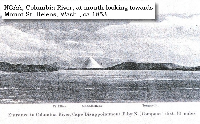
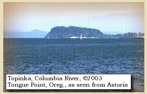
Tongue Point:
Tongue Point, at Columbia River Mile 16 on the Oregon side of the Columbia, is a bold, rocky peninsula, 308 feet high, covered with trees and connected with the south bank by a low, narrow neck. It projects into the river for 0.8 mile. Lewis and Clark named the feature "Point William" after Captain Clark, however it did not stick. Tongue Point was named in 1792 by Lieutenant William Broughton, part of the Vancouver expedition. For ten days in 1805, Captain Clark and some of the men camped on the downstream side of Tongue Point while Captain Lewis, with five men, conducted a reconnaissance of the area and sought a secure location for winter quarters. -- NOAA Office of Coast Survey Website, 2003, and Washington State Historical Society Website, 2004, "Lasting Legacy".


Map, 1814, Lewis and Clark on the Columbia, click to enlarge Map, 1855, Northwest Oregon and mouth Columbia River, click to enlarge Map, 1887, Mouth of the Columbia River, click to enlarge Map, 1987, Youngs Bay, Smith Point, Astoria, click to enlarge Map, 1987, Tongue Point, western part of Cathlamet Bay, click to enlarge Map, 1987, Tongue Point, John Day River, western part of Cathlamet Bay, click to enlarge NASA Image, 2001, Mouth of the Columbia River, click to enlarge Engraving, 1848, Fort George (Astoria), click to enlarge Engraving, ca.1853, Mount St. Helens and the mouth of the Columbia River, click to enlarge Image, 1889, Mount St. Helens and the mouth of the Columbia River, click to enlarge Image, 2003, Tongue Point, Oregon
  1. 1814 Map, Lewis and Clark's map of the Columbia River (section of original). (Click to enlarge.) Astoria, Smith Point, and Tongue Point are depicted but not named. Includes three of the five volcanoes Lewis and Clark saw and commented on. While the journals mention the expedition seeing Mount Adams, it does not appear on their map. Mount Jefferson is to the south (bottom) and off the map. From the "Nicholas Biddle/Paul Allen" 1814 publication. Original Map: "A Map of Lewis and Clark's Track, Across the Western Portion of North America, From the Mississippi to the Pacific Ocean". From: History of the expedition under the command of Captains Lewis and Clark : to the sources of the Missouri, thence across the Rocky Mountains and down the river Columbia to the Pacific Ocean : performed during the years 1804-5-6 : by order of the government of the United States / prepared for the press by Paul Allen. Philadelphia : Bradford and Insskeep, 1814. Harold B. Lee Library, Brigham Young University #upbover maps37. -- Brigham Young University, Harold B. Lee Library Website, 2004.
  2. 1855 Map, Northwest Oregon and mouth of the Columbia River (section of original). (Click to enlarge). Tongue Point is depicted but not named. Includes the Columbia River, Cape Disappointment, Point Adams, Saddle Mountain, Lewis and Clark River, Youngs River. Original Map: From the northern boundary of California to the Columbia River : from explorations and surveys / made under the direction of Hon. Jefferson Davis, Sec. of War by Lieut. R. S. Williamson, U.S. Topl. Engrs. and Lieut. H. L. Abbot, U.S. Topl. Engrs., H. C. Fillebrown, J. Young, and C. D. Anderson, Assts., 1855. Notes: Scale 1:760,320. Relief shown by hachures. At head of title: Routes in Oregon and California. Map no. 2. "Drawn by John Young." From U.S. War Department, Explorations and Surveys for a Railroad Route from the Mississippi River to the Pacific Ocean. Topographical Maps... to Illustrate the Various Reports... (Washington, 1859) Library of Congress American Memory Archives #G4290 1855 .W5 RR 170. -- U.S. Library of Congress Archives, 2004, "American Memory"
  3. 1887 Map (section of original), Mouth of the Columbia River. (Click to enlarge). Original Map: The Columbia River from Celilo to the mouth showing locations of the salmon fisheries, 1887. Scale ca. 1:375,000, Relief shown by hachures. U.S. Army Corps of Engineers, Engineer Office, G.P.O. 1888. University of Washington Archives #UW128. -- University of Washington Library Archives Website, 2002
  4. 1987 Map, Youngs Bay, Smith Point, Astoria (section of original). (Click to enlarge). Office of Coast Surveys, Historical Maps and Charts, Columbia River, Pacific Ocean to Harrington Point, 1987, Chart#18521, 1:40,000. -- NOAA Office of Coast Survey Website, 2004
  5. 1987 Map, Tongue Point and the western part of Cathlamet Bay (section of original). (Click to enlarge). Office of Coast Surveys, Historical Maps and Charts, Columbia River, Pacific Ocean to Harrington Point, 1987, Chart#18521, 1:40,000. -- NOAA Office of Coast Survey Website, 2004
  6. 1987 Map, Tongue Point, John Day River, and the western part of Cathlamet Bay (section of original). (Click to enlarge). Office of Coast Surveys, Historical Maps and Charts, Columbia River, Pacific Ocean to Harrington Point, 1987, Chart#18521, 1:40,000. -- NOAA Office of Coast Survey Website, 2004
  7. 2001, NASA Image, Mouth of the Columbia River, including Tongue Point. (Click to enlarge). NASA Space Shuttle photograph of the mouth of the Columbia River, including the location of Fort Clatsop, the Lewis and Clark National Wildlife Refuge, Tenasillahe Island, Puget Island, and Crim's Island, June 20, 2001. NASA Astronaut Photography of Earth #SS002-724-30. -- NASA Astronaut Photography of Earth Website, 2002
  8. 1848, Watercolor, Fort George formerly Astoria, 1848. (Click to enlarge). This watercolor view portrays Astoria, Oregon, during the year 1845, by Sir Henry James Warre. Tongue Point is in the middleground. Washington State University Photo Archvies #WSU553. -- Washington State University Library Archives Website, 2002
  9. ca.1853, Engraving, mouth of the Columbia River with Tongue Point and Mount St. Helens (section of original). (Click to enlarge). Engraving depicts the Mouth of the Columbia River, Point Ellice, Mount St. Helens, and Tongue Point (just barely discernable on the right). Original also depicts Cape Disappointment and Point Adams. NOAA Photo Archives, America's Coastline Collection #line2075. -- NOAA Photo Archvies Website, 2002
  10. 1889, Engraving/Sketch. Mouth of the Columbia River (section of original). (Click to enlarge). Engraving depicts the Mouth of the Columbia River, Point Ellice, Mount St. Helens, and Tongue Point. Original also depicts Scarborough Hill. From: NOAA Library, Pacific Coast Coast Pilot of California, Oregon, and Washington, 1889 -- NOAA Photo Archives Website, 2004
  11. 2003, Tongue Point, as seen from Astoria, Oregon. (Click to enlarge). Copyright © 2003 Lyn Topinka, private archives, used with permission.


but the waves then became so high that we could not venture any farther, and we therefore landed on a beautiful shore of pebbles of various colours,


Along the Journey - November 27, 1805
Pebbles of Various Colors:
The colored pebbles were probably derived from the Pliocene-age Troutdale Formation which contains rounded quartz and chert gravels derived from sources upstream in the Columbia Plateaus and deposted in this area by the Columbia River. -- Moulton, 1990, v.6


and encamped near an old Indian hut on the isthmus. [west side of the neck of Tongue Point] In drawing our canoes in shore, we had the misfortune to make a split two feet long in one of them. This isthmus opposed a formidable barrier to the sea, for we now found that the water below is salt, while that above is fresh and well tasted. It rained hard during the whole day; it continued all night, and in the morning,


Along the Journey - November 27, 1805
The Camp - November 27 through December 6, 1805
On the west side of Tongue Point, just east of present-day Astoria, Oregon. The majority of the party under Captain Clark remained here until December 7, 1805, while Captain Lewis and five men scouted for a suitable winter camp.


Thursday, November 28, 1805
began more violently, attended with a high wind from the southwest. It was now impossible to proceed on so rough a sea. We therefore sent several men to hunt, and the rest of us remained during the day, in a situation the most cheerless and uncomfortable. On this little neck of land [the men are on the west side of Tongue Point] we are exposed with a miserable covering, which does not deserve the name of a shelter to the violence of the winds; all our bedding and stores, as well as our bodies are completely wet, our clothes rotting with constant exposure, and no food except the dried fish brought from the falls, to which we are again reduced. The hunters all returned hungry, and drenched with rain, having seen neither deer nor elk, and the swan and brant too shy to be approached. At noon the wind shifted to the northwest, and blew with such tremendous fury that many trees were blown down near us. This gale lasted with short intervals during the whole night; but towards morning,


Along the Journey - November 28, 1805
The Camp - November 27 through December 6, 1805
On the west side of Tongue Point, just east of present-day Astoria, Oregon. The majority of the party under Captain Clark remained here until December 7, 1805, while Captain Lewis and five men scouted for a suitable winter camp.


Friday, November 29, 1805
the wind lulled, though the rain continued, and the waves were still high. Captain Lewis took the Indian canoe, which is better calculated for rough weather, and with five men went down to a small bay below us [Youngs Bay], where we expect to find elk.
"... the wind being so high the party were unable to proceed with the perogues. I determined therefore to proceed down the river on it's E. side in surch of an eligible place for our winters residence and accordingly set out early this morning in the small canoe accompanyed by 5 men. drewyer R. Fields, Shannon, Colter & labiesh. proceeded along the coast. ... 5 m. to a point of land passing two points one at 3 m. bearing S 10 W. and the 2ed at 1 1/2 further a little retreating from the 1st land high and woods thick. 2 ml. along the point, land still high and thickly timbered here a deep bay commences runing 2 m. along the bay. the land more open, pass a small prarie at 1 M. ..." [Lewis, November 28, 1805]

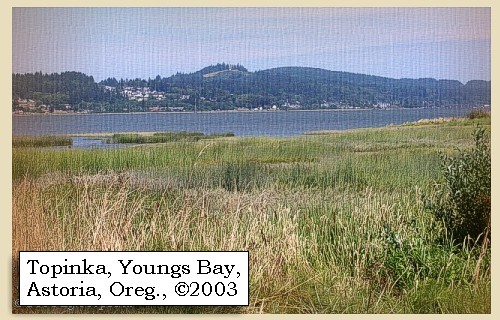
Captain Lewis and his men entered passed by Smith Point (Astoria, Oregon) and entered Youngs Bay.


Along the Journey - November 29, 1805
Astoria-Megler Bridge, Smith Point, and Astoria, Oregon, 2003

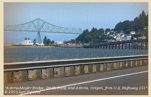
Smith Point and Astoria:
Smith Point, Astoria, Oregon, is located at Columbia River Mile 11.3 on the Oregon side of the Columbia, and is the eastern-most point of Youngs Bay, and the western termination of a high wooded ridge. Smith Point is the first prominent point on the southern bank of the Columbia southeast of Point Adams. The ridge culminates in Coxcomb Hill, 595 feet high, behind Astoria. Captain Clark used "Point Meriwether," after Lewis's first name, to identify this land, however the name did not stick. Throughout history, Smith Point has had many names, a result of the long-disputed sovereignty over the Pacific Northwest. In 1792, after exploring the Columbia River, Lieutenant Broughton named the feature "Point George," honoring the king of England and emphasizing Great Britain's territorial claims. The point became "Point Astoria" when the first commercial settlement of Americans on the Pacific Coast was founded by John Jacob Astor in 1811. In 1813 the Americans surrendered the point to the British as a result of the British-American War of 1812. The British rechristened the trading post, built Fort George, and used the "Point George" name again. The name Astoria was gradually restored after Americans reclaimed the settlement five years later, with the point's name still not settled. The present name for the point is derived from early American settler Sammuel Smith, who took up a donation land claim on the point. -- NOAA Office of Coast Survey Website, 2003, and Washington State Historical Society Website, 2002


Map, 1798, Mouth of the Columbia River, click to enlarge Map, 1814, Lewis and Clark on the Columbia, click to enlarge Map, 1833, Illman and Pilbrow, Columbia River, click to enlarge Map, 1849, Alexander Ross's Columbia River, click to enlarge Map, 1853, Washington and Oregon and the Columbia River, click to enlarge Map, 1855, Mouth of the Columbia River, click to enlarge Map, 1855, Northwest Oregon and mouth Columbia River, click to enlarge Map, 1887, Mouth of the Columbia River, click to enlarge Map, 1949, Youngs Bay, Smith Point, Astoria, click to enlarge Map, 1987, Youngs Bay, Smith Point, Astoria, click to enlarge NASA Image, 2001, Mouth of the Columbia River, click to enlarge Engraving, 1848, Fort George (Astoria), click to enlarge Image, 1986, Mouth of the Columbia River with Astoria and the Astoria-Megler Bridge, click to enlarge Image, 2003, Astoria-Megler Bridge, Smith Point, and Astoria, Oregon
  1. 1798 Map, Mouth of the Columbia River (section of original). (Click to enlarge). Inset map of original, showing the mouth of the Columbia River, including Cape Disappointment, Point Adams, Youngs River, Point George (today's Astoria), and Grays Bay. Original Map: George Vancouver's "A Chart Shewing Part of the Coast of N.W. America." In A Voyage of discovery to the North Pacific ocean, and Round the World. London, 1798. University of Virginia Special Collection "Lewis & Clark, The Maps of Exploration 1507-1814". -- University of Virginia Library Archives Website, 2004
  2. 1814 Map, Lewis and Clark's map of the Columbia River (section of original). (Click to enlarge.) Astoria, Smith Point, and Tongue Point are depicted but not named. Includes three of the five volcanoes Lewis and Clark saw and commented on. While the journals mention the expedition seeing Mount Adams, it does not appear on their map. Mount Jefferson is to the south (bottom) and off the map. From the "Nicholas Biddle/Paul Allen" 1814 publication. Original Map: "A Map of Lewis and Clark's Track, Across the Western Portion of North America, From the Mississippi to the Pacific Ocean". From: History of the expedition under the command of Captains Lewis and Clark : to the sources of the Missouri, thence across the Rocky Mountains and down the river Columbia to the Pacific Ocean : performed during the years 1804-5-6 : by order of the government of the United States / prepared for the press by Paul Allen. Philadelphia : Bradford and Insskeep, 1814. Harold B. Lee Library, Brigham Young University #upbover maps37. -- Brigham Young University, Harold B. Lee Library Website, 2004.
  3. 1833 Map (section of original), Columbia River. (Click to enlarge). Includes Mount Hood and Mount Jefferson. Note: Mount Baker is depicted (upper middle) but Mounts Adams, Rainier and St. Helens are missing. The Columbia River is shown as "Oregon River" at its mouth and "Columbia or Oregon R." further inland. "Wappatoo Valley" is labeled. Also shows Fort Clatsop ("F. Clatsop or F. George"), the Willamette River ("Multnomah R."), Sandy River ("Quicksand R."), John Day River ("R.La Page"), Walla Walla River ("Wallwullah R."), Snake River ("Lewis R."), and the Yakima River ("Tapete R."). Original Map: Oregon Territory, 1833. Creator: Illman & Pilbrow, published by Illman & Pilbrow, New York. Comments: Illman & Pilbrow is the engraving firm which copyrighted and published this map, the actual artist is unknown. Washington State University Digital Maps Collection #WSU323. University of Washington Digital Maps Collection #UW104. -- Washington State University Early Washington Maps Digital Collection Website, 2004
  4. 1849 Map (section of original), Alexander Ross's Columbia River. (Click to enlarge). Original Map: Map of the Columbia to illustrate Ross's adventures. Author: Alexander Ross; Publication Date: 1849; Publisher: London, Smith, Elder and Co., 1849. Washington State University Archives #WSU478. -- Washington State University Early Washington Maps Digital Collection Website, 2004
  5. 1853 Map, Washington and Oregon and the Columbia River, from the Clearwater River to the Snake River and down the Columbia River to the Pacific Ocean (section of original). (Click to enlarge). Includes: Clearwater River (Kooskooski), Lapwai Creek (Lapwai R.), Snake River (Saptin or Lewis R.), Columbia River (Columbia R.), Yakima River (Yakima R.), Walla Walla River (Wallawalla R.), Umatilla River (Umatilla R.), Willow Creek (Quesnells R.), John Day River (John day's R.), Deschutes River (Fall R.), Willamette River (Willammette R.), and Cowlitz River (Cowlitz R.). Original Map: "Map of California, Oregon, Washington, Utah, and New Mexico (1853)", by Thomas Cowperthwait & Co. Washington State University Archives #WSU22. -- Washington State University Library Collections Website, 2003
  6. 1855 Map, Mouth of the Columbia River, with Cape Disappointment and Long Beach Peninsula (section of original). (Click to enlarge). Original Map: "Map of a part of the Territory of Washington : to accompany report of Surveyor General (1855)". By James Tilton, Washington (State) Surveyor General's Office. Relief shown by hachures, Scale 1:1,140,480. Washington State University Historical Maps Collection #WSU314, and University of Washington Map Collection #UW114. -- Washington State University Library Archives Website, 2004
  7. 1855 Map, Northwest Oregon and mouth of the Columbia River (section of original). (Click to enlarge). Includes the Columbia River, Cape Disappointment, Point Adams, Saddle Mountain, Lewis and Clark River, Youngs River. Original Map: From the northern boundary of California to the Columbia River : from explorations and surveys / made under the direction of Hon. Jefferson Davis, Sec. of War by Lieut. R. S. Williamson, U.S. Topl. Engrs. and Lieut. H. L. Abbot, U.S. Topl. Engrs., H. C. Fillebrown, J. Young, and C. D. Anderson, Assts., 1855. Notes: Scale 1:760,320. Relief shown by hachures. At head of title: Routes in Oregon and California. Map no. 2. "Drawn by John Young." From U.S. War Department, Explorations and Surveys for a Railroad Route from the Mississippi River to the Pacific Ocean. Topographical Maps... to Illustrate the Various Reports... (Washington, 1859) Library of Congress American Memory Archives #G4290 1855 .W5 RR 170. -- U.S. Library of Congress Archives, 2004, "American Memory"
  8. 1887 Map (section of original), Mouth of the Columbia River. (Click to enlarge). Original Map: The Columbia River from Celilo to the mouth showing locations of the salmon fisheries, 1887. Scale ca. 1:375,000, Relief shown by hachures. U.S. Army Corps of Engineers, Engineer Office, G.P.O. 1888. University of Washington Archives #UW128. -- University of Washington Library Archives Website, 2002
  9. 1949 Map, Youngs Bay, Smith Point, Astoria (section of originial). (Click to enlarge). Office of Coast Surveys, Historical Maps and Charts, Columbia River, Pacific Ocean to Harrington Point, 1949, Chart#6151, 1:40,000. -- NOAA Office of Coast Survey Website, 2004
  10. 1987 Map, Youngs Bay, Smith Point, Astoria (section of original). (Click to enlarge). Office of Coast Surveys, Historical Maps and Charts, Columbia River, Pacific Ocean to Harrington Point, 1987, Chart#18521, 1:40,000. -- NOAA Office of Coast Survey Website, 2004
  11. 2001, NASA Image, Mouth of the Columbia River, including Astoria. (Click to enlarge). NASA Space Shuttle photograph of the mouth of the Columbia River, including the location of Fort Clatsop, the Lewis and Clark National Wildlife Refuge, Tenasillahe Island, Puget Island, and Crim's Island, June 20, 2001. NASA Astronaut Photography of Earth #SS002-724-30. -- NASA Astronaut Photography of Earth Website, 2002
  12. 1848, Watercolor, Fort George formerly Astoria, 1848. (Click to enlarge). This watercolor view portrays Astoria, Oregon, during the year 1845, by Sir Henry James Warre. Tongue Point is in the middleground. Washington State University Photo Archvies #WSU553. -- Washington State University Library Archives Website, 2002
  13. 1986, Aerial view looking west towards the mouth of the Columbia River at Astoria and the Astoria-Megler Bridge. (Click to enlarge). Photographer: Bob Heims. Photograph Date: August 1, 1986. U.S. Army Corps of Engineers Photo Archives #Col0356.jpg. -- U.S. Army Corps of Engineers Photo Archives Website, 2003
  14. 2003, Astoria-Megler Bridge, Smith Point, and Astoria, Oregon, as seen for the U.S. Highway 101 bridge across Youngs Bay. (Click to enlarge). Copyright © 2003 Lyn Topinka, private archives, used with permission.


Youngs Bay, 2003

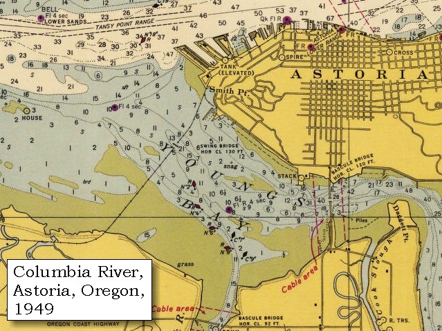
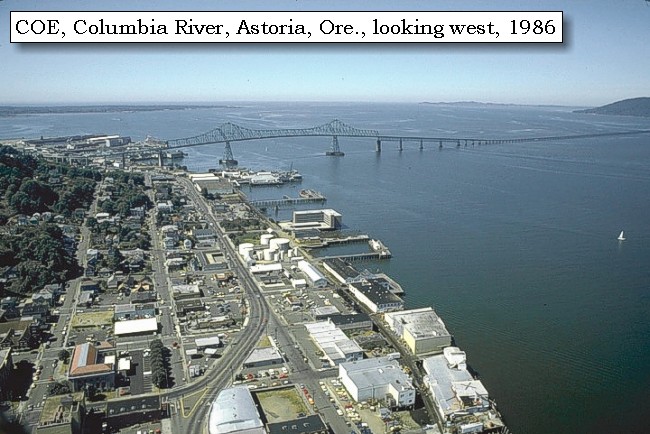
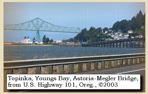
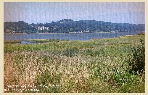
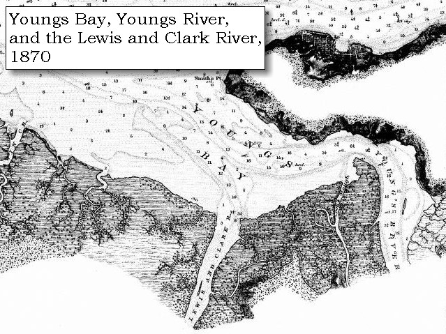
Youngs Bay:
Youngs Bay is a shallow body of water just west of Smith Point. The bay is crossed by U.S. Highway 26/101 vertical-lift highway bridge, approximately 0.3 mile above the junction of Youngs Bay with the Columbia River. Youngs Bay is a part of the Columbia River estuary. It receives water from four major streams - the Lewis and Clark River, Youngs River, Klatskanine River, and Wallooskee River. Captain Clark named the bay "Meriwether Bay" after Meriwether Lewis. Today the bay is named after the Youngs River, a river named in 1792 by Lieutenant William Broughton after Sir George Young of the Royal Navy. -- NOAA Office of Coast Survey Website, 2003, and Washington State Historical Society Website, 2004, "Lasting Legacy".


Map, 1798, Mouth of the Columbia River, click to enlarge Map, 1814, Lewis and Clark on the Columbia, click to enlarge Map, 1870, Youngs Bay, Lewis and Clark River, Youngs River, click to enlarge Map, 1887, Mouth of the Columbia River, click to enlarge Map, 1949, Youngs Bay, Smith Point, Astoria, click to enlarge Map, 1987, Youngs Bay, Smith Point, Astoria, click to enlarge NASA Image, 2001, Mouth of the Columbia River, click to enlarge Image, 2003, Youngs Bay, Oregon
  1. 1798 Map, Mouth of the Columbia River (section of original). (Click to enlarge). Inset map of original, showing the mouth of the Columbia River, including Cape Disappointment, Point Adams, Youngs River, Point George (today's Astoria), and Grays Bay. Original Map: George Vancouver's "A Chart Shewing Part of the Coast of N.W. America." In A Voyage of discovery to the North Pacific ocean, and Round the World. London, 1798. University of Virginia Special Collection "Lewis & Clark, The Maps of Exploration 1507-1814". -- University of Virginia Library Archives Website, 2004
  2. 1814 Map, Lewis and Clark's map of the Columbia River (section of original). (Click to enlarge.) Youngs Bay is depicted but not named. Also depicted but not named are the Lewis and Clark River (left) and Youngs River (right) which empty into Youngs Bay. Map includes three of the five volcanoes Lewis and Clark saw and commented on. While the journals mention the expedition seeing Mount Adams, it does not appear on their map. Mount Jefferson is to the south (bottom) and off the map. From the "Nicholas Biddle/Paul Allen" 1814 publication. Original Map: "A Map of Lewis and Clark's Track, Across the Western Portion of North America, From the Mississippi to the Pacific Ocean". From: History of the expedition under the command of Captains Lewis and Clark : to the sources of the Missouri, thence across the Rocky Mountains and down the river Columbia to the Pacific Ocean : performed during the years 1804-5-6 : by order of the government of the United States / prepared for the press by Paul Allen. Philadelphia : Bradford and Insskeep, 1814. Harold B. Lee Library, Brigham Young University #upbover maps37. -- Brigham Young University, Harold B. Lee Library Website, 2004.
  3. 1870 Map (section of original), Youngs Bay, Lewis and Clark River, and Youngs River. (Click to enlarge). Office of Coast Surveys, Historical Maps and Charts, Columbia River, Columbia River, Sheet No.1, 1870, Plate No.1130, 1:40,000. -- NOAA Office of Coast Survey Website, 2004
  4. 1887 Map (section of original), Mouth of the Columbia River. (Click to enlarge). Original Map: The Columbia River from Celilo to the mouth showing locations of the salmon fisheries, 1887. Scale ca. 1:375,000, Relief shown by hachures. U.S. Army Corps of Engineers, Engineer Office, G.P.O. 1888. University of Washington Archives #UW128. -- University of Washington Library Archives Website, 2002
  5. 1949 Map, Youngs Bay, Smith Point, Astoria (section of originial). (Click to enlarge). Office of Coast Surveys, Historical Maps and Charts, Columbia River, Pacific Ocean to Harrington Point, 1949, Chart#6151, 1:40,000. -- NOAA Office of Coast Survey Website, 2004
  6. 1987 Map, Youngs Bay, Smith Point, Astoria (section of original). (Click to enlarge). Office of Coast Surveys, Historical Maps and Charts, Columbia River, Pacific Ocean to Harrington Point, 1987, Chart#18521, 1:40,000. -- NOAA Office of Coast Survey Website, 2004
  7. 2001, NASA Image, Mouth of the Columbia River, including Youngs Bay. (Click to enlarge). NASA Space Shuttle photograph of the mouth of the Columbia River, including the location of Fort Clatsop, the Lewis and Clark National Wildlife Refuge, Tenasillahe Island, Puget Island, and Crim's Island, June 20, 2001. NASA Astronaut Photography of Earth #SS002-724-30. -- NASA Astronaut Photography of Earth Website, 2002
  8. 2003, Youngs Bay and part of Astoria, Oregon, as seen from the U.S. Highway 26/101 Bridge crossing the bay. (Click to enlarge). Copyright © 2003 Lyn Topinka, private archives, used with permission.


Three other men set out at the same time to hunt in different directions, and the rest remained round the smoke of our fires drying leather, in order to make some new clothes. The night brought only a continuation of rain and hail, with short intervals of fair weather, till in the morning,


Along the Journey - November 29, 1805
The Camp - November 27 through December 6, 1805
On the west side of Tongue Point, just east of present-day Astoria, Oregon. The majority of the party under Captain Clark remained here until December 7, 1805, while Captain Lewis and five men scouted for a suitable winter camp.


Saturday, November 30, 1805
it cleared up about nine o'clock, and the sun shone for several hours. Other hunters were now sent out, and we passed the remainder of the day in drying our merchandise so long exposed. ...... The hills along the coast are high and steep, and the general covering is a growth of lofty pines of different species, some of which rise more than two hundred feet, and are ten or twelve feet in diameter near the root. Besides these trees we observe on the point a species of ash, the alder, the laurel, one species of the wild crab, and several kinds of underbrush, among which the rosebushes are conspicuous.


Along the Journey - November 30, 1805
The Camp - November 27 through December 6, 1805
On the west side of Tongue Point, just east of present-day Astoria, Oregon. The majority of the party under Captain Clark remained here until December 7, 1805, while Captain Lewis and five men scouted for a suitable winter camp.


Home Previous Continue


If you have questions or comments please contact: GS-CVO-WEB@usgs.gov
June/July 2004, Lyn Topinka
The Volcanoes of Lewis and Clark Home Page | CVO Home Page