The Volcanoes of
Lewis and Clark
March 25 - 28, 1806
Heading Home - Puget Island to Deer Island
 
Home
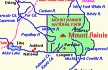
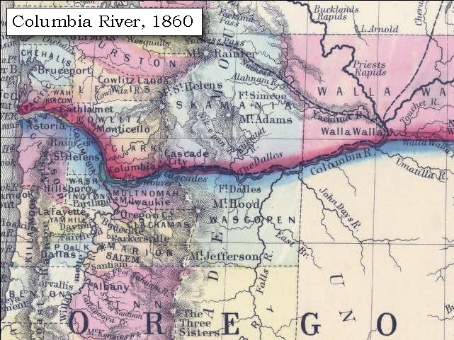
The Volcanoes of Lewis and Clark

Map of the Journey
Volcanoes, Basalt Plateaus, Major Rivers, etc.

The Volcanoes
Mount Adams, Mount Hood, Mount Jefferson, Mount Rainier, and Mount St. Helens

CALENDAR of the Journey
October 1805 to June 1806

Along the Journey
Pacific Northwest Maps - Columbia River, Volcanoes, Flood Basalts, Missoula Floods, Geology, etc.

The Corps of Discovery
The Journey of Lewis and Clark

About the Reference Materials
The Journals, Biddle/Allen, DeVoto, Gass, Moulton, Topo Maps, and others

USGS Lewis and Clark Links
Links to USGS Websites highlighting the Lewis and Clark Journey

Resources
Publications Referenced and Websites Visited


PREVIOUS

March 23-24
Heading Home, Fort Clatsop to Tenasillahe Island
March 25-28

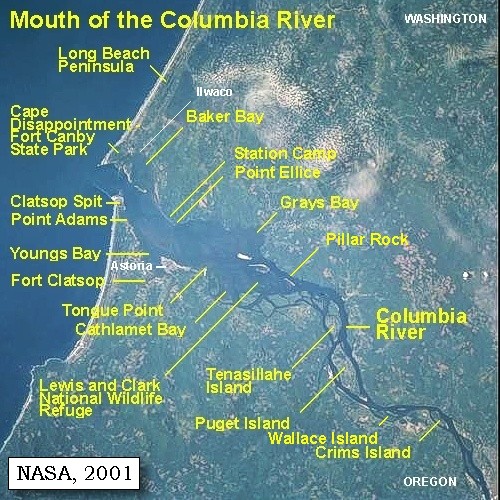
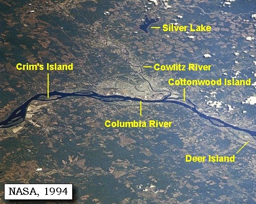
Heading Home,
Puget Island to Deer Island

Puget Island, Clatskanie River and Beaver Slough, Crims Island, Island above Crims, Longview (Washington) and Rainier (Oregon), Lewis and Clark Bridge, Mount Rainier and Mount St. Helens, Mount Coffin, Cowlitz River, Goble Volcanics, Deer Island
CONTINUE

March 29
Heading Home, Deer Island to Ridgefield NWR
 

On October 7, 1805, Lewis and Clark and the "Corps of Discovery" began their journey down the Clearwater River and into the volcanics of the Pacific Northwest. The Corps travelled from the Clearwater to the Snake and down the "Great Columbia", finally reaching the Pacific Ocean on November 15, 1805. Along the journey they encountered the lava flows of the Columbia Plateau, river channels carved by the great "Missoula Floods", and the awesome beauty of five Cascade Range volcanoes.

Map, Lewis and Clark in the Pacific Northwest, click for brief
                         summary
[Click map for brief summary about the area]


Heading for Home - March 1806
Back on the Columbia - Puget Island to Deer Island
 

Lewis and Clark's camp of March 24, 1806, was on the Oregon side of the Columbia River, northeast of Brownsmead, at Aldrich Point, across from Tenasillahe Island.

Tuesday, March 25, 1806
This morning proved so disagreeably cold that we did not set out before seven o'clock, when having breakfasted, we continued along the southern side of the river. The wind, however, as well as a strong current was against us, so that we proceeded slowly. On landing for dinner at noon, we were joined by some Clatsops ...... After dinner we crossed the river to a large island [Puget Island], along the side of which we continued ......


Along the Journey - March 25, 1806
Puget Island, 2003

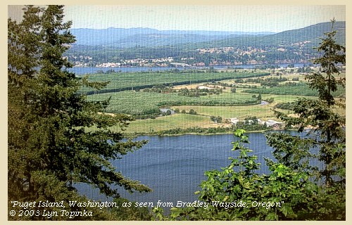
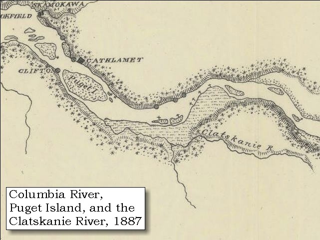
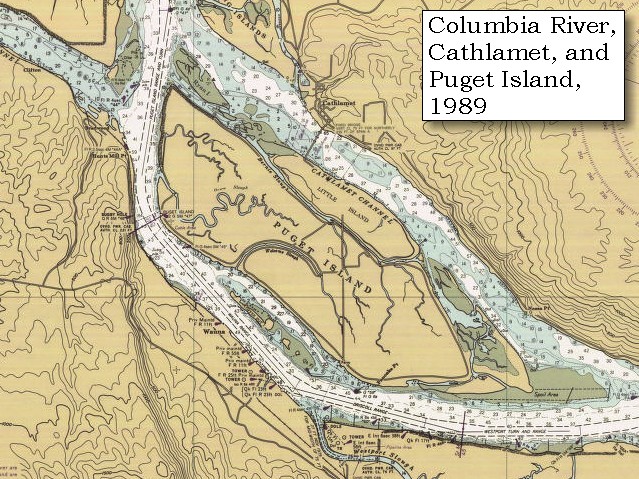
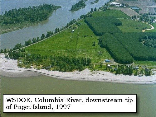
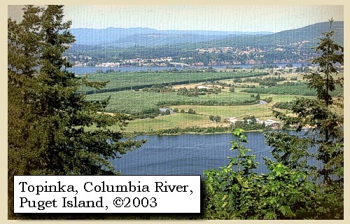
Puget Island:
Lieutenant Broughton, in 1792, named the island for one of Captain Vancouver's lieutenants, Peter Puget. The present place name retains the British identification for the island, named for the same person honored by the naming of Puget Sound. -- Washington State Historical Society Website, 2004, "Lasting Legacy"


Map, 1855, Northwest Oregon and mouth Columbia River, click to enlarge Map, 1887, Puget Island vicinity, click to enlarge Map, 1989, Puget Island Island, click to enlarge NASA Image, 2001, Mouth of the Columbia River, click to enlarge Image, 1997, West tip of Puget Island, click to enlarge Image, 2003, Puget Island
  1. 1855 Map, Northwest Oregon and mouth of the Columbia River (section of original). (Click to enlarge). Puget island is depicted but not named (long island to right of tape). Includes the Columbia River, Cape Disappointment, Point Adams, Saddle Mountain, Lewis and Clark River, Youngs River. Original Map: From the northern boundary of California to the Columbia River : from explorations and surveys / made under the direction of Hon. Jefferson Davis, Sec. of War by Lieut. R. S. Williamson, U.S. Topl. Engrs. and Lieut. H. L. Abbot, U.S. Topl. Engrs., H. C. Fillebrown, J. Young, and C. D. Anderson, Assts., 1855. Notes: Scale 1:760,320. Relief shown by hachures. At head of title: Routes in Oregon and California. Map no. 2. "Drawn by John Young." From U.S. War Department, Explorations and Surveys for a Railroad Route from the Mississippi River to the Pacific Ocean. Topographical Maps... to Illustrate the Various Reports... (Washington, 1859) Library of Congress American Memory Archives #G4290 1855 .W5 RR 170. -- U.S. Library of Congress Archives, 2004, "American Memory"
  2. 1887 Map (section of original), Columbia River and the Puget Island vicinity. (Click to enlarge). Original Map: The Columbia River from Celilo to the mouth showing locations of the salmon fisheries, 1887. Scale ca. 1:375,000, Relief shown by hachures. U.S. Army Corps of Engineers, Engineer Office, G.P.O. 1888. University of Washington Archives #UW128. -- University of Washington Library Archives Website, 2002
  3. 1989 Map, Puget Island (section of original). (Click to enlarge). Also includes Cathlamet, Washington. Office of Coast Surveys, Historical Maps and Charts, Columbia River, Harrington Point to Crims Island, 1989, Chart#18523, 1:40,000. -- NOAA Office of Coast Survey Website, 2004
  4. 2001, NASA Image, Mouth of the Columbia River, including the location of Fort Clatsop. (Click to enlarge). NASA Space Shuttle photograph of the mouth of the Columbia River, including the location of Fort Clatsop, the Lewis and Clark National Wildlife Refuge, Tenasillahe Island, Puget Island, and Crims Island, June 20, 2001. NASA Astronaut Photography of Earth #SS002-724-30. -- NASA Astronaut Photography of Earth Website, 2002
  5. 1997, Aerial view, west tip of Puget Island. (Click to enlarge). Washington State Department of Ecology Shorelines Aerial Photo #WAH0097, May 13, 1997. -- Washington State Department of Ecology Website, 2002
  6. 2003, Puget Island, Washington, as seen from Bradley Wayside, Oregon. (Click to enlarge). Copyright © 2003 Lyn Topinka, private archives, used with permission.


We proceeded on to the head of the island [Puget Island], and then crossed to the north side of the river [some of the men, see below]. Here the coast formed a continued swamp for several miles back, so that it was late in the evening before we were able to reach a spot fit for our camp.

The Biddle/Allen publication is mis-leading -- according to the Journals as printed in Moulton, 1991, Vol.7, only three of the expedition traveled on the north side of the Columbia. The rest of the men were on the south side. The main camp for March 25, 1806, was near the Clastskanie River on the Oregon side.

"... Last night and this morning are cool wend hard a head and tide going out, after an early brackfast we proceeded on about 4 miles and came too on the South Side to worm and dry our Selves a little. ... as the wind was hard a head and tide against us we Concluded to delay untill the return of the tide which we expected at 1 oClock, at which hour we Set out ... we crossed over to an Island on which was a Cath lahmah fishing Camp of one Lodge; ... we remained at this place about half an hour and then Continued our rout. the winds in the evening was verry hard, it was with Some dificuelty that we Could find a Spot proper for an encampment, the Shore being a Swamp for Several miles back; at length late in the evening opposit to the place we had encamped on the 6th of Novr. last; we found the enterance of a Small Creek which offered us a Safe harbour from the Winds and Encamped. the Ground was low and moist tho' we obtained a tolerable encampment. ... here we found Drewyer and the 2 Fields' who had been Seperated from us Since Morning; they had passed on the North Side of the large Island which was much nearest. ... made 15 Miles ..." [Clark, March 25, 1806]
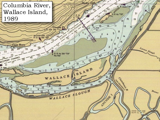
At length we discovered the entrance of a small creek [Clatskanie River/Beaver Slough], opposite to the place where we were encamped on the sixth of November [On the Washington side between Eagle Cliff and Cape Horn, across from Wallace Island],


Along the Journey - March 25, 1806
Clatskanie River and Clatskanie, Oregon, 2004

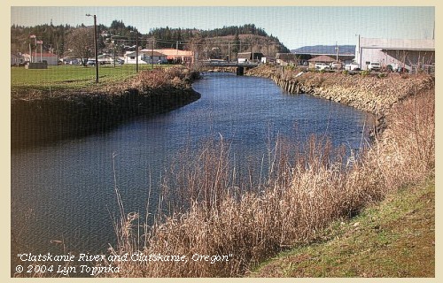
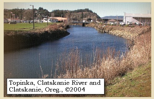
Clatskanie River and Beaver Slough:
The Clatskanie River is a tributary of the Beaver Slough, which enters Wallace Slough near the southeast end of Wallace Island. The town of Clatskanie, Oregon, is four miles inland and was named after the Tlatskanai tribe who lived in the hills south of the Clatskanie River. The Tlatskanai, linguistically an Athapascan tribe, originally lived in the flat lands bordering the Chehalis River in Washington State. As game became scarce and their food supply diminished, they left the area, heading south, and crossed the Columbia River to occupy the hills traditionally occupied by the Chinook Indians, who were a large Indian tribe living along the Oregon Coast. After driving away the more peaceful Chinook Indians, the Tlatskanai established themselves within the Clatskanie-Westport area, and extended their numbers into the head of the Nehalem. The word "Tlatskanai" was used by these Indians to denote the route they took to get to a particular meeting place, applying to particular steams and not to others. White men carelessly applied this work to the name of the stream. One source lists "Tlatskanai" as meaning "swift running water." The Clatskanie is indeed a swift beautiful stream. Other names that existed for the Tlatskanai were the Clackstar, Klatskanai and Klaatshan, among others. -- NOAA Office of Coast Survey Website, 2003, and Clatskanie Chamber of Commerce Website, 2003


Map, 1887, Puget Island vicinity, click to enlarge Map, 1989, Cape Horn, Eagle Cliff, Wallace Island, Wallace Slough, Beaver Slough, click to enlarge Image, 2004, Clatskanie River
  1. 1887 Map (section of original), Columbia River and the Puget Island vicinity, including the Clatskanie River. (Click to enlarge). Original Map: The Columbia River from Celilo to the mouth showing locations of the salmon fisheries, 1887. Scale ca. 1:375,000, Relief shown by hachures. U.S. Army Corps of Engineers, Engineer Office, G.P.O. 1888. University of Washington Archives #UW128. -- University of Washington Library Archives Website, 2002
  2. 1989 Map, Cape Horn, Eagle Cliff, Wallace Island, Wallace Slough, Clatskanie River and Beaver Slough. (Click to enlarge). Office of Coast Surveys, Historical Maps and Charts, Columbia River, Harrington Point to Crims Island, 1989, Chart#18523, 1:40,000. -- NOAA Office of Coast Survey Website, 2004
  3. 2004, Clatskanie River and the town of Clatskanie, Oregon. (Click to enlarge). Copyright © 2004 Lyn Topinka, private archives, used with permission.


and though the ground was low and moist, yet as the spot was sheltered from the wind, we resolved to pass the night there [near the Clatskanie River and the today's town of Clatskanie, Oregon]: we had now made fifteen miles. ...... The wind was very high towards evening. ......


Along the Journey - March 25, 1806
The Camp - March 25, 1806:
Near the Clatskanie River and today's town of Clatskanie, Oregon.


Wednesday, March 26, 1806
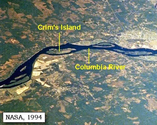
The wind ...... continued to blow so violent in the morning, that we could not set out before eight o'clock. ...... The wind having abated, we proceeded to an old village, where we halted for dinner [on the southern bank, opposite the west end of Crims Island], having met on the way Sahawacap the principal chief of all the Cathlamahs, who was on his return from a trading voyage up the river, with wappatoo and fish, some of which he gave us, and we purchased a little more. ...... After dinner we passed along the north shore opposite to a high fine bottom and dry prairie [today an area upstream of Clatskanie, Oregon, containing Beaver and McLean Sloughs], at the upper end of which, near a grove of white-oak trees, is an island which we called Fanny's island [Crims Island].
"... The wind blew So hard untill 8 A M. that we detained, ... we Continued our rout up the river to an old Village on the South Side where we halted for dinner ... halted for dinner at an Old Village on the South point opposit the lower pt. of Fannys Island. ..."
[Clark, March 26, 1806]
"... after dinner we proceeded on and passed an Elegant and extensive bottom on the South side and an island near it's upper point which we call Fanny's Island and bottom. the great part of the bottom is a high dry prarie. ..."
[Lewis, March 26, 1806]


Along the Journey - March 26, 1806
Crims Island, 2003

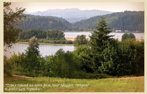
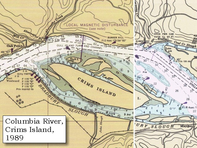
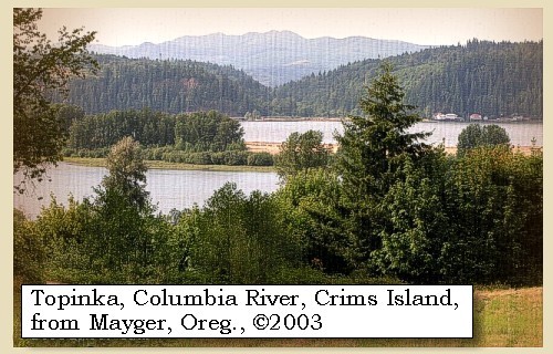
Crims Island:
Lewis and Clark named this island "Fanny's Island", after Captain Clark's younger sister Frances, on their journey home in 1806. In 1792 William Broughton called the island "Baker's Island" for a Second Lieutenant in Captain Vancouver's command. Charles Wilkes, in 1841, named the island "Gull", which now is the name of the small island north of the west end of Crims Island. Today it retains the surname of a pioneer homesteader on the island. -- Washington State Historical Society Website, 2004, "Lasting Legacy"


Map, 1887, Puget Island vicinity, click to enlarge Map, 1989, Crims Island, click to enlarge NASA Image, 2001, Mouth of the Columbia River, click to enlarge NASA Image, 1994, Columbia River and Crims Island to Deer Island, click to enlarge NASA Image, 1994, Columbia River and Crims Island vicinity, click to enlarge Image, 2003, Crims Island
  1. 1887 Map (section of original), Columbia River including the Clatskanie River. (Click to enlarge). Crims Island is not named on the map, but is the 3rd island to the right of Puget Island (compare to the NASA aerials). Original Map: The Columbia River from Celilo to the mouth showing locations of the salmon fisheries, 1887. Scale ca. 1:375,000, Relief shown by hachures. U.S. Army Corps of Engineers, Engineer Office, G.P.O. 1888. University of Washington Archives #UW128. -- University of Washington Library Archives Website, 2002
  2. 1989 Map, Crims Island and Bradbury Slough (section of original). (Click to enlarge). Office of Coast Surveys, Historical Maps and Charts, Left half: Columbia River, Harrington Point to Crims Island, 1989, Chart#18523, 1:40,000. Right half: Columbia River, Crims Island to St. Helens, 1988, Chart#18524, 1:40,000. -- NOAA Office of Coast Survey Website, 2004
  3. 2001, NASA Image, Mouth of the Columbia River, including the location of Fort Clatsop. (Click to enlarge). NASA Space Shuttle photograph of the mouth of the Columbia River, including the location of Fort Clatsop, the Lewis and Clark National Wildlife Refuge, Tenasillahe Island, Puget Island, and Crims Island, June 20, 2001. NASA Astronaut Photography of Earth #SS002-724-30. -- NASA Astronaut Photography of Earth Website, 2002
  4. 1994, NASA Image, Columbia River from Crims Island to Deer Island (section of original). (Click to enlarge). View from space - north-northeast-looking, low-oblique photograph, showing a section of the Columbia River from Crims Island to Deer Island, including the Cowlitz River, October 1994. The Columbia River is flowing right to left in this image (east to west). Washington State is the upper half of the image (north) and Oregon is to the bottom half (south). NASA Earth from Space #STS068-262-025. -- NASA Earth from Space Website, 2002
  5. 1994, NASA Image, Columbia River and Crims Island vicinity (section of original). (Click to enlarge). View from space - north-northeast-looking, low-oblique photograph, showing a section of the Columbia River in the vicinity of Crim's Island, October 1994. The Columbia River is flowing right to left in this image (east to west). Crims Island is the long island on the right side of the light-colored point of land. On the left of the image is an area containing the Westport Slough and the two halves of Wallace Island. The river (barely visible) entering the Columbia here is the Clatskanie River. Washington State is to the north (top) and Oregon is to the south (bottom). NASA Earth from Space #STS068-262-025. -- NASA Earth from Space Website, 2002
  6. 2003, Crims Island, as seen from the road to Mayger, Oregon. (Click to enlarge). Copyright © 2003 Lyn Topinka, private archives, used with permission.


There were some deer and elk at a distance in the prairie, but as we could not stay to hunt, we continued till late in the evening, when we encamped on the next island [possibly Walker Island or Dibblee (formerly Lord) islands] above Fanny's [Crims Island]. According to the estimate we made in descending the river, which we begin, however, to think was short, our journey of to-day was eighteen miles. ......
"... after dinner I walked on Shore through an eligant bottom on the South Side opposit to Fannys Island. This bottom we also Call fannys bottom it is extensive and an open leavel plain except near the river bank which is high dry rich oak land. I saw Some deer & Elk at a distance in the Prarie. we continued untill late in the evening and encamped on a Small Island near the Middle of the river haveing made 18 Miles. ..."
[Clark, March 26, 1806]


Along the Journey - March 26, 1806
Campsite of March 26, 1806:
"Next island above Crims Island".


Map, 1887, Puget Island vicinity, click to enlarge NASA Image, 1994, Columbia River and Crims Island to Deer Island, click to enlarge NASA Image, 1994, Columbia River and Crims Island vicinity, click to enlarge
  1. 1887 Map (section of original), Columbia River including the Clatskanie River. (Click to enlarge). Crims Island is not named on the map, but is the 3rd island to the right of Puget Island (compare to the NASA aerials). Original Map: The Columbia River from Celilo to the mouth showing locations of the salmon fisheries, 1887. Scale ca. 1:375,000, Relief shown by hachures. U.S. Army Corps of Engineers, Engineer Office, G.P.O. 1888. University of Washington Archives #UW128. -- University of Washington Library Archives Website, 2002
  2. 1994, NASA Image, Columbia River from Crims Island to Deer Island (section of original). (Click to enlarge). View from space - north-northeast-looking, low-oblique photograph, showing a section of the Columbia River from Crims Island to Deer Island, including the Cowlitz River, October 1994. The Columbia River is flowing right to left in this image (east to west). Washington State is the upper half of the image (north) and Oregon is to the bottom half (south). NASA Earth from Space #STS068-262-025. -- NASA Earth from Space Website, 2002
  3. 1994, NASA Image, Columbia River and Crims Island vicinity, showing smaller islands upstream (right) (section of original). (Click to enlarge). View from space - north-northeast-looking, low-oblique photograph, showing a section of the Columbia River in the vicinity of Crim's Island, October 1994. The Columbia River is flowing right to left in this image (east to west). Crims Island is the long island on the right side of the light-colored point of land. On the left of the image is an area containing the Westport Slough and the two halves of Wallace Island. The river (barely visible) entering the Columbia here is the Clatskanie River. Washington State is to the north (top) and Oregon is to the south (bottom). NASA Earth from Space #STS068-262-025. -- NASA Earth from Space Website, 2002


Along the Journey - March 26, 1806
The Camp - March 26, 1806:
On an island in the middle of the Columbia River, in the vicinity of today's Walker Island.


Thursday, March 27, 1806
We set out early, and were soon joined by some Skilloots, with fish and roots for sale. At ten o'clock we stopped to breakfast at two houses of the same nation, where we found our hunters, who had not returned to camp last night, but had killed nothing. The inhabitants seemed very kind and hospitable. ......

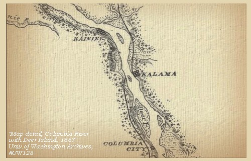
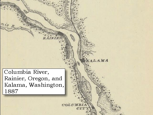
Today, Longview, Washington, and Rainier, Oregon, are along this stretch of the Columbia. The Lewis and Clark Bridge connects the two cities.


Along the Journey - March 27, 1806
Longview, Washington, and Mount Rainier, 2004

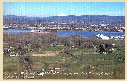
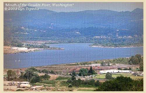
Longview, Washington:
Longview, Washington, is located at the confluence of the Cowlitz and Columbia Rivers at River Mile 57. Less than seventy-five years ago, the area of Longview was a sparsely populated wilderness and rural homesteads. The first written account of the area can be found in the journals of Lewis and Clark which camped beside the "Cow-elis-kee" River in 1805. In 1849, pioneeers began to arrive in this area to settle along the river. Harry Huntington named the settlement "Monticello" in honor of Thomas Jefferson's home in Virginia. In 1852, people from all over what was to become Washington state gathered in Monticello to draft a memorial to Congress. The memorial expressed their desire to be granted statehood under the name of Columbia. This meeting came to be known as the Monticello Convention. The desires of the Convention were met favorably in Congress, but it was decided that a state named Columbia might be confused with the preexisting District of Columbia. The state was instead named Washington in honor of our first president. Today, a monument to the Monticello Convention stands not far from the Longview Civic Center. Longview city was the dream of Robert Alexander Long, a midwestern businessman whose holdings included the Long-Bell Lumber Company. This firm in 1918 claimed to be the largest lumber retailer and manufacturer in the United States. With southern timber stands vanishing quickly, Long redirected his effort to tapping the Pacific Northwest's abundant old-growth forest. Part of Long's vision was the planned city of Longview. NOAA Office of Coast Survey Website, 2003, City of Longview Website, 2003, and U.S. Library of Congress, American Memories Website, 2003

Rainier, Oregon:
Rainier, Oregon, was named for Mount Rainier, which is often visible to the northeast [see below]. Rainier was an important stop in the days of river commerce. The town was founded by Charles E. Fox in 1851, was first called Eminence, later changed to Fox's Landing, and finally to Rainier. In 1854 F.M. Warren erected a large steam sawmill and began producing lumber for the homes and other buildings of the settlers. Rainier, Oregon, was incorporated in 1885. Oregon State Archives Website, 2002


Map, 1854, Columbia River, Fort Vancouver area, click to enlarge Map, 1887, Cowlitz River vicinity, click to enlarge Map, 1988, Longview, Washington, and the Cowlitz River, click to enlarge Image, 1927, Long-Bell Ferry, at location of today's Lewis and Clark Bridge, click to enlarge Image, 2004, Longview, Washington, and Mount Rainier Image, 2004, Mount Rainier as seen from Rainier, Oregon Image, 2004, Mount St. Helens and the Lewis and Clark Bridge
  1. 1853-54 Map, Columbia River, including the Fort Vancouver area (section of original). (Click to enlarge). Includes Longview, Washington (Monticello), Coweeman River (Minter R.), Kalama River (Ca-la-ma R.), Lewis River (Cath-la-pootle R.), Willamette River, Fort Vancouver, Cape Horn, and "The Cascades". Vancouver Lake is depicted but not labeled. Original Map: "Rocky Mountains to Puget Sound : from explorations and surveys / made under the direction of the Hon. Jefferson Davis, Secretary of War by Isaac I. Stevens Governor of Washington Territory, 1853-4." Inset: (Supplementary sketch) Reconnaissance of the railroad route from Wallawalla to Seattle via Yak-e-mah River & Snoqualmie Pass. By A. W. Tinkham in January 1854. Drawn by J. R. P. Mechlin. 20 x 28 cm. Topographer, John Lambert, Published in Washington D.C., 1859, 1:1,200,000, Notes: From the U.S. War Department, Explorations and Surveys for a Railroad Route from the Mississippi River to the Pacific Ocean, Topographical Maps, to Illustrate the Various Reports, U.S. Library of Congress American Memories Reference "LC Railroad Maps #156". -- U.S. Library of Congress, American Memories Website, 2004
  2. 1887 Map (section of original), Columbia River and the Cowlitz River vicinity. (Click to enlarge). Original Map: The Columbia River from Celilo to the mouth showing locations of the salmon fisheries, 1887. Scale ca. 1:375,000, Relief shown by hachures. U.S. Army Corps of Engineers, Engineer Office, G.P.O. 1888. University of Washington Archives #UW128. -- University of Washington Library Archives Website, 2002
  3. 1988 Map, Longview, Washington, and the Cowlitz River(section of original). (Click to enlarge). Office of Coast Surveys, Historical Maps and Charts, Columbia River, Crims Island to St. Helens, 1988, Chart#18524, 1:40,000. -- NOAA Office of Coast Survey Website, 2004
  4. 1927, Long-Bell Ferry landing west of the Longview Dock, present site of today's Lewis and Clark Bridge. (Click to enlarge). Looking across the Columbia River at Rainier, Oregon. Photograph Date: 1927. City of Longview Archives, Longview Public Library. -- City of Longview Website, 2003
  5. 2004, Longview, Washington, and Mount Rainier, as seen from Rainier, Oregon. (Click to enlarge). Copyright © 2004 Lyn Topinka, private archives, used with permission.
  6. 2004, Mount Rainier, Washington, as seen from near Rainier, Oregon. (Click to enlarge). Copyright © 2004 Lyn Topinka, private archives, used with permission.
  7. 2004, Mount St. Helens, Washington, and the Lewis and Clark Bridge, as seen from near Rainier, Oregon. (Click to enlarge). The Lewis and Clark Bridge connects Longview, Washington, with Rainier, Oregon. Copyright © 2004 Lyn Topinka, private archives, used with permission.


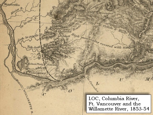
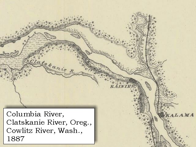
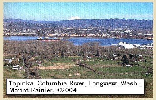
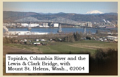
Lewis and Clark Bridge:
Completed in 1930, the Lewis and Clark Bridge (Longview-Rainier Bridge) spans the Columbia River between Longview, Washington and Rainier, Oregon. At the time of construction this bridge was the longest cantilever span in North America with its 1,200-feet central section. -- U.S. Library of Congress, American Memories Website, 2003


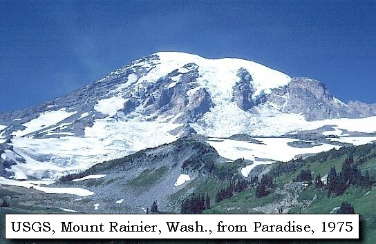
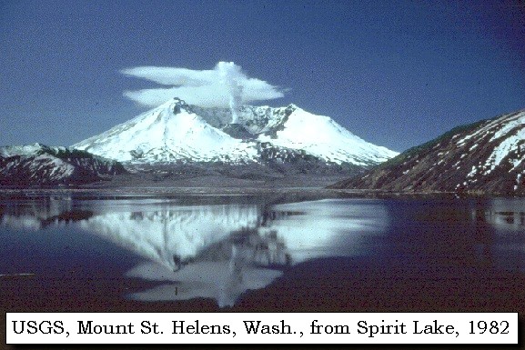
If the day had been clear, Mount Rainier and Mount St. Helens would have been visible from the Oregon side of the Columbia River.


Along the Journey - March 27, 1806
Mount Rainier, Washington, as seen from near Rainier, Oregon, 2004

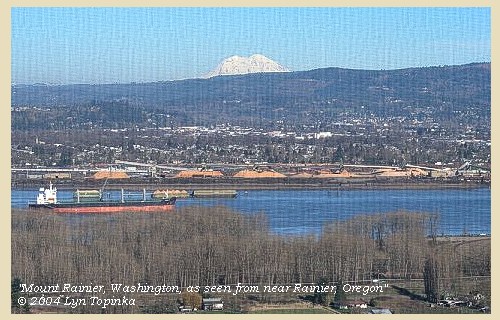
Mount Rainier as seen from near Rainier, Oregon:
Mount Rainier, Washington, is the highest (14,410 feet) and third-most voluminous volcano in the Cascades after Mount Shasta, California, and Mount Adams, Washington. Mount Rainier is, however, the most dangerous volcano in the range, owing to the large population and to the huge area and volume of ice and snow on its flanks that could theoretically melt to generate debris flows during cataclysmic eruptions.


Map, the Volcanoes of Lewis and Clark, click to enlarge Map, 1992, Mount Rainier and Vicinity, click to enlarge Map, 1853, Washington and Oregon and the Columbia River, click to enlarge Map, 1855, Columbia River, Vancouver to the Pacific, click to enlarge Map, 1860, Columbia River, Washington, Oregon, click to enlarge Image, 1975, Mount Rainier as seen from Paradise, click to enlarge Image, 2004, Mount Rainier as seen from Rainier, Oregon
  1. Map, "Lewis and Clark Volcano Sitings"
  2. 1992 Map, Mount Rainier and Vicinity, with major stream drainages. (Click to enlarge). The Green, White, Puyallup, and Nisqually Rivers flow into Puget Sound. The Cowlitz River drains south and eventually enters the Columbia River (not shown on map). The Toutle River drainage from Mount St. Helens flows into the Cowlitz River upstream of Castle Rock, Washington. Modified from Scott, et.al., 1992, USGS Open-File Report 90-385.
  3. 1853 Map, Washington and Oregon and the Columbia River, from the Clearwater River to the Snake River and down the Columbia River to the Pacific Ocean (section of original). (Click to enlarge). Includes: Clearwater River (Kooskooski), Lapwai Creek (Lapwai R.), Snake River (Saptin or Lewis R.), Columbia River (Columbia R.), Yakima River (Yakima R.), Walla Walla River (Wallawalla R.), Umatilla River (Umatilla R.), Willow Creek (Quesnells R.), John Day River (John day's R.), Deschutes River (Fall R.), Willamette River (Willammette R.), and Cowlitz River (Cowlitz R.). Original Map: "Map of California, Oregon, Washington, Utah, and New Mexico (1853)", by Thomas Cowperthwait & Co. Washington State University Archives #WSU22. -- Washington State University Library Collections Website, 2003
  4. 1855 Map, Columbia River from Vancouver to the Pacific, including Mount St. Helens (section of original). (Click to enlarge). Original Map: "Map of Oregon and Washington Territories: showing the proposed Northern Railroad route to the Pacific Ocean, by John Disturnell, 1855. University of Washington Archives #UW155. -- University of Washington Library Collections Website, 2002
  5. 1860 Map, Columbia River, Washington State, and Oregon (section of original). (Click to enlarge). Original Map: Map of Oregon, Washington, and British Columbia, (1860). This map dates between March 2nd, 1861 (when the Dakota Territory was formed) and March 4th, 1863 (when the Idaho Territory was formed from eastern Washington and western Dakota) Nearing retirement from a thirty year long and rather successful career, S. Augustus Mitchell printed this map showcasing Oregon, the Territory of Washington, and British Columbia. Washington became a territory in 1853, arguing that distances to Willamette Valley kept them from obtaining a voice in the Oregon territorial government. As this map shows, when it split from Oregon proper the Washington territory included parts of Wyoming and Montana and all of Idaho. Territorial government for Idaho would not be approved until 1863. When Mitchell retired he left the business for his son to manage. Washington State University Archives #WSU7. -- Washington State University Archives, 2004
  6. 1975, USGS Photo showing Mount Rainier, Washington, from Paradise (Click to enlarge). Photographer: Lyn Topinka, Date: 1975. -- USGS Cascades Volcano Observatory Photo Archives, 2004
  7. 2004, Mount Rainier, Washington, as seen from near Rainier, Oregon. (Click to enlarge). Copyright © 2004 Lyn Topinka, private archives, used with permission.


Mount St. Helens and the Lewis and Clark Bridge, 2004

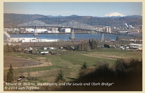
Mount St. Helens as seen from near Rainier, Oregon:
Mount St. Helens (8,364 feet, 9,677 feet before May 18, 1980) is located in southwestern Washington about 50 miles northeast of Portland, Oregon, and is one of several lofty volcanic peaks that dominate the Cascade Range of the Pacific Northwest. On May 18, 1980, the volcano was transformed. The catastrophic eruption, was preceded by 2 months of intense activity that included more than 10,000 earthquakes, hundreds of small phreatic (steam-blast) explosions, and the outward growth of the volcano's entire north flank by more than 260 feet. A magnitude 5.1 earthquake struck beneath the volcano at 8:32 a.m. on May 18, setting in motion the devastating eruption.


Map, the Volcanoes of Lewis and Clark, click to enlarge Map, 1978, Mount St. Helens and Vicinity, click to enlarge Map, 1853, Washington and Oregon and the Columbia River, click to enlarge Map, 1855, Columbia River, Vancouver to the Pacific, click to enlarge Map, 1860, Columbia River, Washington, Oregon, click to enlarge Image, 1978, Mount St. Helens, before the May 18, 1980 eruption, click to enlarge Image, 1982, Mount St. Helens from Spirit Lake, click to enlarge Image, 2004, Mount St. Helens and the Lewis and Clark Bridge
  1. Map, "Lewis and Clark Volcano Sitings"
  2. 1978 Map, Mount St. Helens and Vicinity, and its major river drainages. (Click to enlarge). Swift Creek, Pine Creek, and the Muddy River drain the southern flanks of Mount St. Helens and drain into the Lewis River. The Kalama River drains west into the Columbia River. The North and South Fork Toutle Rivers drain to the north west and enter the Cowlitz (a tributary from Mount Rainier), which drains into the Columbia River south of Longview, Washington. Map modified from Crandell and Mullineaux, 1978, USGS Bulletin 1383-C.
  3. 1853 Map, Washington and Oregon and the Columbia River, from the Clearwater River to the Snake River and down the Columbia River to the Pacific Ocean (section of original). (Click to enlarge). Includes: Clearwater River (Kooskooski), Lapwai Creek (Lapwai R.), Snake River (Saptin or Lewis R.), Columbia River (Columbia R.), Yakima River (Yakima R.), Walla Walla River (Wallawalla R.), Umatilla River (Umatilla R.), Willow Creek (Quesnells R.), John Day River (John day's R.), Deschutes River (Fall R.), Willamette River (Willammette R.), and Cowlitz River (Cowlitz R.). Original Map: "Map of California, Oregon, Washington, Utah, and New Mexico (1853)", by Thomas Cowperthwait & Co. Washington State University Archives #WSU22. -- Washington State University Library Collections Website, 2003
  4. 1855 Map, Columbia River from Vancouver to the Pacific, including Mount St. Helens (section of original). (Click to enlarge). Original Map: "Map of Oregon and Washington Territories: showing the proposed Northern Railroad route to the Pacific Ocean, by John Disturnell, 1855. University of Washington Archives #UW155. -- University of Washington Library Collections Website, 2002
  5. 1860 Map, Columbia River, Washington State, and Oregon (section of original). (Click to enlarge). Original Map: Map of Oregon, Washington, and British Columbia, (1860). This map dates between March 2nd, 1861 (when the Dakota Territory was formed) and March 4th, 1863 (when the Idaho Territory was formed from eastern Washington and western Dakota) Nearing retirement from a thirty year long and rather successful career, S. Augustus Mitchell printed this map showcasing Oregon, the Territory of Washington, and British Columbia. Washington became a territory in 1853, arguing that distances to Willamette Valley kept them from obtaining a voice in the Oregon territorial government. As this map shows, when it split from Oregon proper the Washington territory included parts of Wyoming and Montana and all of Idaho. Territorial government for Idaho would not be approved until 1863. When Mitchell retired he left the business for his son to manage. Washington State University Archives #WSU7. -- Washington State University Archives, 2004
  6. 1978, View of Mount St. Helens, before the eruption of May 18, 1980. (Click to enlarge). U.S. Army Corps of Engineers Photograph #Sce0234. Photograph Date: 1978. Photographer: unknown. From: U.S. Army Corps of Engineers Photo Archives. -- U.S. Army Corps of Engineers Website, 2002
  7. 1982, USGS Photo showing Mount St. Helens after the May 18, 1980 eruption. The volcano is reflected in Spirit Lake. (Click to enlarge). Photographer: Lyn Topinka, Date: May 19, 1982. -- USGS Cascades Volcano Observatory Photo Archives, 2004
  8. 2004, Mount St. Helens, Washington, and the Lewis and Clark Bridge, as seen from near Rainier, Oregon. (Click to enlarge). The Lewis and Clark Bridge connects Longview, Washington, with Rainier, Oregon. Copyright © 2004 Lyn Topinka, private archives, used with permission.


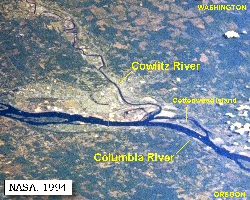
At the distance of two miles we passed the entrance of Coweliskee river [Cowlitz River]. This stream discharges itself on the north side of the Columbia, about three miles above a remarkably high rocky knoll [Mount Coffin], the south side of which it washes in passing, and which is separated from the northern hills by a wide bottom of several miles in extent.


Along the Journey - March 27, 1806
Mount Coffin:
Marked as "Knob," a descriptive notation, on the route map, the large rock was observed by the corps as they hurried toward the Pacific Ocean. The "remarkable knob" was used by the natives for interment of their dead and was noted by other earlier travelers on the river. The 240-foot basalt landmark was leveled for its gravel during port construction at Longview, Washington. Mount Coffin was the name given by Broughton in 1792 because of several Indians being buried in canoes in the vicinity. Captain Clark's wording gives the impression that the rock was on an island, but its historic location is on the mainland in the area of Longview, just downstream from the mouth of the Cowlitz River. Clark's estimate of 80 feet was considerably short of it's height when it existed. Beginning in the early 1900's Mount Coffin was extensively quarried and leveled. It was composed of the volcanic unit of the Eocene-age Cowlitz Formation. -- Washington State Historical Society Website, 2002, and Moulton, 1990, v.6


Map, 1949, Columbia River, Mount Coffin, Longview, Cowlitz River, click to enlarge
  1. 1949 Map, Columbia River, Mount Coffin and Longview, Washington. (Click to enlarge). The Cowlitz River is visible on the right. Office of Coast Surveys, Historical Maps and Charts, Columbia River, Crims Island to Saint Helens, 1949, Chart#6153, 1:40,000. -- NOAA Office of Coast Survey Website, 2004


The Coweliskee [Cowlitz River] is one hundred and fifty yards wide, deep and navigable, as the Indians assert, for a considerable distance, and most probably waters the country west and north of the range of mountains [Cascade Mountains] which cross the Columbia between the great falls and rapids. On the lower side of this river, a few miles from its entrance into the Columbia, is the principal village of the Skilloots, a numerous people ......


Along the Journey - March 27, 1806
Mouth of the Cowlitz River, 2003

Cowlitz River:
The "Cow-e-lis-kee River" was noted on Lewis and Clark's westbound exploration but actually named on the homeward journey. The Cowlitz River originates on the west slope of of the Cascade Range in southwest Washington State. The river flows west and then then south to where it empties into the Columbia River at Kelso, Washington, at River Mile (RM) 68. The Cowlitz River drains approximately 2,480 square miles over a distance of 151 miles. Principle tributaries to the Cowlitz River include the Coweman, Toutle, Tilton, Cispus, Ohanapecosh and the Clear Fork. The Toutle River is the largest, draining 512 square miles and enters the Cowlitz River at RM 20.0. The Cispus River (RM 89.8) is the most significant tributary in the upper Basin and drains 433 square miles. The mainstem above the confluence of the Cispus-Cowlitz River drains 609 square acres. The runoff from portions of Mount Rainier, Mount Adams and Mount St. Helens drains into the Cowlitz River. These normally inactive volcanoes have helped shape the geography of the area. For example, the eruption of Mt. St. Helens on May 18, 1980 sent a tidal wave of melted ice and pulverized rock down the Toutle Valley into the Cowlitz River, and carried so much of this coarse sandy material and debris all the way to the Columbia River that dredging was required to clear the channel before river shipping could be resumed. Large scale removal of this volcanic material in the Cowlitz River began at the lower end of the Toutle River by July, 1980 and continued on down the Cowlitz River until engineers were reasonably confident that the cleared channel could handle expected winter flows without topping dikes and flooding Castle Rock, Longview and Kelso. A dam to control sediment was then constructed further up the Toutle River by the Corp of Engineers to prevent the re-silting of the dredged sections. -- Columbia Basin Fish and Wildlife Authority Website, 2004, and Washington State Historical Society Website, 2004, "Lasting Legacy".


Map, 1992, Mount Rainier and Vicinity, click to enlarge Map, 1814, Lewis and Clark on the Columbia, click to enlarge Map, 1853, Washington and Oregon and the Columbia River, click to enlarge Map, 1887, Cowlitz River vicinity, click to enlarge Map, 1988, Longview, Washington, and the Cowlitz River, click to enlarge NASA Image, 1994, Columbia River from Crim's Island to Deer Island, including the Cowlitz River, click to enlarge NASA Image, 1994, Columbia River and the mouth of the Cowlitz River, click to enlarge Image, 1980, Mouth of the Cowlitz River, carrying Toutle River sediment from Mount St. Helens, click to enlarge Image, 2003, Mouth of the Cowlitz River
  1. 1992 Map, Mount Rainier and Vicinity, with major stream drainages. (Click to enlarge). The Green, White, Puyallup, and Nisqually Rivers flow into Puget Sound. The Cowlitz River drains south and eventually enters the Columbia River (not shown on map). The Toutle River drainage from Mount St. Helens flows into the Cowlitz River upstream of Castle Rock, Washington. Modified from Scott, et.al., 1992, USGS Open-File Report 90-385.
  2. 1814 Map, Lewis and Clark's map of the Columbia River (section of original). (Click to enlarge.) Map shows the Cowlitz River ("Cow-elis-kee R."). Map includes three of the five volcanoes Lewis and Clark saw and commented on. While the journals mention the expedition seeing Mount Adams, it does not appear on their map. Mount Jefferson is to the south (bottom) and off the map. From the "Nicholas Biddle/Paul Allen" 1814 publication. Original Map: "A Map of Lewis and Clark's Track, Across the Western Portion of North America, From the Mississippi to the Pacific Ocean". From: History of the expedition under the command of Captains Lewis and Clark : to the sources of the Missouri, thence across the Rocky Mountains and down the river Columbia to the Pacific Ocean : performed during the years 1804-5-6 : by order of the government of the United States / prepared for the press by Paul Allen. Philadelphia : Bradford and Insskeep, 1814. Harold B. Lee Library, Brigham Young University #upbover maps37. -- Brigham Young University, Harold B. Lee Library Website, 2004.
  3. 1853 Map, Washington and Oregon and the Columbia River, from the Clearwater River to the Snake River and down the Columbia River to the Pacific Ocean (section of original). (Click to enlarge). Includes: Clearwater River (Kooskooski), Lapwai Creek (Lapwai R.), Snake River (Saptin or Lewis R.), Columbia River (Columbia R.), Yakima River (Yakima R.), Walla Walla River (Wallawalla R.), Umatilla River (Umatilla R.), Willow Creek (Quesnells R.), John Day River (John day's R.), Deschutes River (Fall R.), Willamette River (Willammette R.), and Cowlitz River (Cowlitz R.). Original Map: "Map of California, Oregon, Washington, Utah, and New Mexico (1853)", by Thomas Cowperthwait & Co. Washington State University Archives #WSU22. -- Washington State University Library Collections Website, 2003
  4. 1887 Map (section of original), Columbia River and the Cowlitz River vicinity. (Click to enlarge). Original Map: The Columbia River from Celilo to the mouth showing locations of the salmon fisheries, 1887. Scale ca. 1:375,000, Relief shown by hachures. U.S. Army Corps of Engineers, Engineer Office, G.P.O. 1888. University of Washington Archives #UW128. -- University of Washington Library Archives Website, 2002
  5. 1988 Map, Longview, Washington, and the Cowlitz River(section of original). (Click to enlarge). Office of Coast Surveys, Historical Maps and Charts, Columbia River, Crims Island to St. Helens, 1988, Chart#18524, 1:40,000. -- NOAA Office of Coast Survey Website, 2004
  6. 1994, NASA Image, Columbia River from Crim's Island to Deer Island (section of original). (Click to enlarge). View from space - north-northeast-looking, low-oblique photograph, showing a section of the Columbia River from Crim's Island to Deer Island, including the Cowlitz River, October 1994. The Columbia River is flowing right to left in this image (east to west). Washington State is the upper half of the image (north) and Oregon is to the bottom half (south). NASA Earth from Space #STS068-262-025. -- NASA Earth from Space Website, 2002
  7. 1994, NASA Image, Columbia River and the mouth of the Cowlitz River (section of original). (Click to enlarge). View from space - North-northeast-looking, low-oblique photograph, showing a section of the Columbia River at the mouth of the Cowlitz River (center), October 1994. The city of Kelso, Washington is located at the mouth of the Cowlitz. On the west side of the Columbia (bottom of image) is Columbia County, Oregon. White puffs on the right are clouds. NASA Earth from Space #STS068-262-025. -- NASA Earth from Space Website, 2002
  8. 1980, Aerial view of the mouth of the Cowlitz River, carrying Toutle River sediment from the May 18, 1980 eruption of Mount St. Helens. (Click to enlarge). The Cowlitz (left) enters the Columbia River (right) at Kelso, Washington. Note two dredges, one at the mouth of the Cowlitz and on in the Columbia. Photographer: Bill Johnson. Photograph Date: July 1, 1980. U.S. Army Corps of Engineers Photo Archives #Msh0661.jpg. -- U.S. Army Corps of Engineers Photo Archives Website, 2003
  9. 2003, Mouth of the Cowlitz River, Washington, as seen from near Rainier, Oregon. (Click to enlarge). Copyright © 2003 Lyn Topinka, private archives, used with permission.


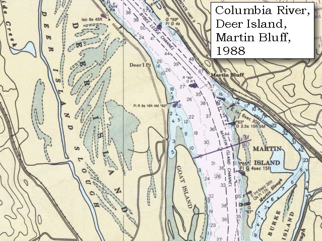
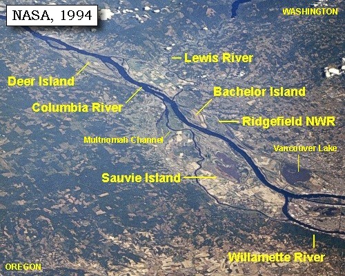
Late in the evening we halted at the beginning of the bottom land, below Deer island [near Goble, Oregon, across from today's Sandy Island and Kalama, Washington], after having made twenty miles.


Along the Journey - March 27, 1806
Goble Volcanics:
The thick sequence of basaltic flows and pyroclastic rocks (late Eocene-early Oligocene) that crop out on both sides of the Columbia River in southwestern Washington and northwestern Oregon are mapped as Goble Volcanics in Oregon, and informal or lithologic names are applied to the rocks on the Washington side. The type area is the vicinity of Goble, Oregon, where a thickness of more than 5,000 feet was mapped by Wilkingson and others (1946). The volcanics form cliffs along the Columbia River (and today's Interstate-5) for several miles. Subaerial lava flows, agglomerates, and oxidized soil horizons are typical features of the cliff exposures. The basalt is generally fresh, fine grained, and has masses of iddingsite scattered throughout along with microphenocrysts of plagioclase and pyroxene. Rock types include pillow, columnar or hackly jointed, massive or vesicular basalt flows and dikes. -- Armentrout, etc., 1980, and Evarts, 2002


Map, 1988, Goble Oregon, Sandy Island, Kalama, Washington, click to enlarge
  1. 1988 Map, Goble, Oregon, Sandy Island, Kalama, Washington (section of original). (Click to enlarge). Office of Coast Surveys, Historical Maps and Charts, Upper section: Columbia River, Crims Island to Saint Helens, 1988, Chart#18523, 1:40,000, Lower section: Columbia River, Saint Helens to Vancouver, 1988, Chart#18524, 1:40,000. -- NOAA Office of Coast Survey Website, 2004


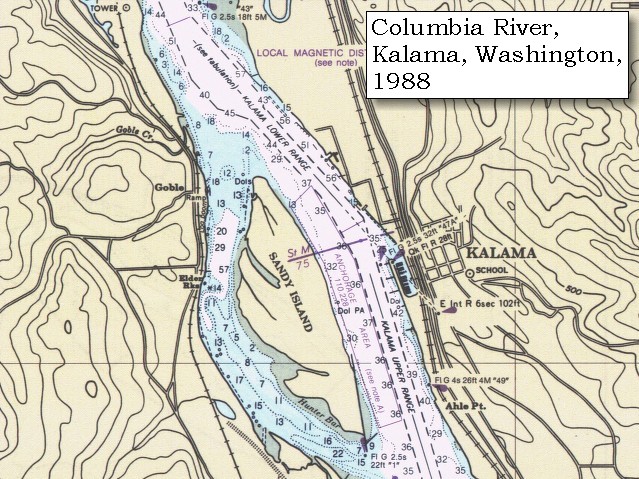
Along the low grounds on the river were the cottonwood, sweet-willow, the oak, ash, the broad-leafed ash, and the growth resembling the beech; while the hills are occupied almost exclusively by different species of fir, and the black alder is common to the hills as well as the low ground. ......


Along the Journey - March 27, 1806
The Camp - March 27, 1806:
On the Oregon side of the Columbia River in the vicinity of Goble, across from today's Sandy Island and Kalama, Washington.


Friday, March 28, 1806
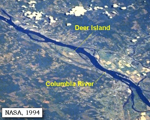
We left our camp at an early hour, and by nine o'clock reached an old Indian village on the left side of Deer island [Deer Island]. Here we found a party of our men whom we had sent on yesterday to hunt ...... This island, which has received from the Indians the appropriate name of Elalah, or Deer island, is surrounded on the water side by an abundant growth of cotton-wood, ash, and willow, while the interior consists chiefly of prairies interspersed with ponds. ......


Along the Journey - March 28, 1806
Deer Island Map, 1887

Deer Island:
Deer Island is Holocene and Pleistocene alluvium, unconsolidated, poorly sorted to well-sorted, massive to laminated, commonly cross-stratified sand, silt, and minor gravel of the Columbia River floodplain. Locally includes fine-grained lacustrine, aeolian, and organic-rich marsh deposits. -- Evarts, 2002


Map, 1814, Lewis and Clark on the Columbia, click to enlarge Map, 1887, Kalama vicinity, click to enlarge Map, 1887, Lewis River vicinity, click to enlarge Map, 1988, Deer Island, and Martin Bluff, Washington, click to enlarge NASA Image, 1994, Columbia River, Crim's Island to Deer Island, click to enlarge NASA Image, 1994, Columbia River, Deer Island to the Willamette River, click to enlarge NASA Image, 1994, Columbia River and Deer Island, click to enlarge
  1. 1814 Map, Lewis and Clark's map of the Columbia River (section of original). (Click to enlarge.) Shows Deer Island ("Deer I."). Map also includes three of the five volcanoes Lewis and Clark saw and commented on. While the journals mention the expedition seeing Mount Adams, it does not appear on their map. Mount Jefferson is to the south (bottom) and off the map. From the "Nicholas Biddle/Paul Allen" 1814 publication. Original Map: "A Map of Lewis and Clark's Track, Across the Western Portion of North America, From the Mississippi to the Pacific Ocean". From: History of the expedition under the command of Captains Lewis and Clark : to the sources of the Missouri, thence across the Rocky Mountains and down the river Columbia to the Pacific Ocean : performed during the years 1804-5-6 : by order of the government of the United States / prepared for the press by Paul Allen. Philadelphia : Bradford and Insskeep, 1814. Harold B. Lee Library, Brigham Young University #upbover maps37. -- Brigham Young University, Harold B. Lee Library Website, 2004.
  2. 1887 Map (section of original), Columbia River and the Kalama vicinity, including Deer Island. (Click to enlarge). Original Map: The Columbia River from Celilo to the mouth showing locations of the salmon fisheries, 1887. Scale ca. 1:375,000, Relief shown by hachures. U.S. Army Corps of Engineers, Engineer Office, G.P.O. 1888. University of Washington Archives #UW128. -- University of Washington Library Archives Website, 2002
  3. 1887 Map (section of original), Columbia River and the Lewis River vicinity, including Deer Island. (Click to enlarge). Original Map: The Columbia River from Celilo to the mouth showing locations of the salmon fisheries, 1887. Scale ca. 1:375,000, Relief shown by hachures. U.S. Army Corps of Engineers, Engineer Office, G.P.O. 1888. University of Washington Archives #UW128. -- University of Washington Library Archives Website, 2002
  4. 1988 Map, Deer Island, Oregon, and Martin Bluff, Washington (section of original). (Click to enlarge). Office of Coast Surveys, Historical Maps and Charts, Upper section: Columbia River, Crims Island to Saint Helens, 1988, Chart#18523, 1:40,000, Lower section: Columbia River, Saint Helens to Vancouver, 1988, Chart#18524, 1:40,000. -- NOAA Office of Coast Survey Website, 2004
  5. 1994, NASA Image, Columbia River from Crim's Island to Deer Island (section of original). (Click to enlarge). View from space - north-northeast-looking, low-oblique photograph, showing a section of the Columbia River from Crim's Island to Deer Island, including the Cowlitz River, October 1994. The Columbia River is flowing right to left in this image (east to west). Washington State is the upper half of the image (north) and Oregon is to the bottom half (south). NASA Earth from Space #STS068-262-025. -- NASA Earth from Space Website, 2002
  6. 1994, NASA Image, Columbia River from Deer Island to the Willamette River (section of original). (Click to enlarge). View from space - north-northeast-looking, low-oblique photograph, showing a section of the Columbia River from Deer Island to the Willamette River, including the Lewis River, Sauvie Island, Bachelor Island, and the Ridgefield National Wildlife Refuge, October 1994. The Columbia River is flowing from lower right to upper left in this image (southeast to northwest). Washington State is the upper right of the image and Oregon is to the bottom left. NASA Earth from Space #STS068-262-025. -- NASA Earth from Space Website, 2002
  7. 1994, NASA Image, Columbia River and Deer Island (section of original). (Click to enlarge). View from space - north-northeast-looking, low-oblique photograph, showing a section of the Columbia River and Deer Island, Oregon, October 1994. NASA Earth from Space #STS068-262-025. -- NASA Earth from Space Website, 2002


We had advanced only five miles to-day.


Along the Journey - March 28, 1806
The Camp - March 28, 1806:
On the eastern shore of Deer Island, towards the northern tip. There is a Highway marker on U.S. Highway 30.


Home Previous Continue


If you have questions or comments please contact: GS-CVO-WEB@usgs.gov
June/July 2004, Lyn Topinka
The Volcanoes of Lewis and Clark Home Page | CVO Home Page