Mount Rainier, Washington:
Mount Rainier, the highest (14,410 feet) and third-most voluminous volcano in the Cascades after Mounts Shasta and Adams, dominates the Seattle-Tacoma area, where more than 1.5 million know it fondly as "The Mountain". The Mountain is, however, the most dangerous volcano in the range, owing to the large population and to the huge area and volume of ice and snow on its flanks that could theoretically melt to generate debris flows during cataclysmic eruptions.
Eruptive History:
Mount Rainier is an active volcano that first erupted about half a million years ago. Because of Rainier's great height and northerly location, glaciers have cut deeply into its lavas, making it appear deceptively older than it actually is. Mount Rainier is known to have erupted as recently as in the 1840s, and large eruptions took place as recently as about 1,000 and 2,300 years ago. Mount Rainier and other similar volcanoes in the Cascade Range, such as Mount Adams and Mount Baker, erupt much less frequently than the more familiar Hawaiian volcanoes, but their eruptions are vastly more destructive. Hot lava and rock debris from Rainier's eruptions have melted snow and glacier ice and triggered debris flows (mudflows) - with a consistency of churning wet concrete - that have swept down all of the river valleys that head on the volcano. Debris flows have also formed by collapse of unstable parts of the volcano without accompanying eruptions. Some debris flows have traveled as far as the present margin of Puget Sound, and much of the lowland to the east of Tacoma and the south of Seattle is formed of pre-historic debris from Mount Rainier
"Mount Tahoma"
Northwest American Indians knew the mountain long before European explorers reached the waters of the Pacific Ocean. For generations, they knew the mountain as "Takhoma", "Tahoma", "Ta-co-bet" and several other names. Many of the names mean "big mountain" or "snowy peak," or "place where the waters begin." Little Tahoma is the name of prominent rock outcrop on the east side of Mount Rainier. American Indians living both east and west of Mount Rainier traveled to the high mountain valleys each summer and fall to gather berries and hunt deer, goats, elk, and bear. They often camped near berry fields at altitudes between 3,000 feet and 5,000 feet. The forests and meadows around Mount Rainier were important summer hunting and gathering sites for the Nisqually, Puyallup, Upper Cowlitz, Muckleshoot, and Yakama people. On May 8, 1792, Captain George Vancouver of the British Royal Navy anchored his ship near today's Port Townsend, Washington. He wrote in his log, "... the round snowy mountain ... after my friend Rear Admiral Peter Rainier, I distinguished by the name of Mount Rainier ..."
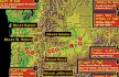
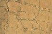
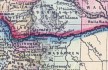

- Map, "Lewis and Clark Volcano Sitings"
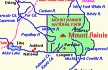
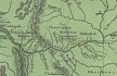
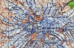
- 1992 Map, Mount Rainier and Vicinity, with major stream drainages. (Click to enlarge).
The Green, White, Puyallup, and Nisqually Rivers flow into Puget Sound. The Cowlitz River drains south and eventually
enters the Columbia River (not shown on map). The Toutle River drainage from Mount St. Helens flows into the Cowlitz
River upstream of Castle Rock, Washington.
Modified from Scott, et.al.,
1992, USGS Open-File Report 90-385.
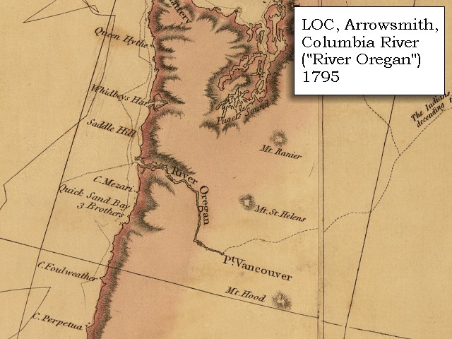
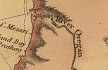
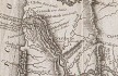
- 1795 Map, Pacific Northwest and the Columbia River (section of original). (Click to enlarge).
Includes the Columbia River ("River Oregan"), Mount Rainier, Mount St. Helens, and Mount Hood, and Point Vancouver.
Original Map: A map exhibiting all the new discoveries in the interior parts of North America / inscribed by permission to the honorable
governor and company of adventurers of England trading into Hudsons Bay in testimony of their liberal communications to
their most obedient and very humble servant A. Arrowsmith, January 1st 1795.
Published: London, 1802. Notes: Relief shown by hachures. Shows "Rivers added east of the Rocky Mountains, 900 L. 450 Lat.," from Tooley's Printed maps of America. In lower margin: London: Published Jan. 1, 1795 by A. Arrowsmith, No. 24 Rathbone Place. Includes notes.
Reference: Tooley. Printed maps of America 137. Scale [ca. 1:3,800,000] (W 1600--W 400/N 700--N 250).
Library of Congress American Memory Archives #G3300 1802 A7 Vault Casetop.
-- U.S. Library of Congress Archives, 2004, "American Memory"
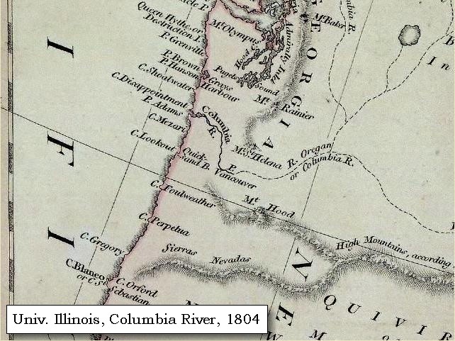
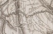
- 1804 Map, Pacific Northwest and the Columbia River (section of original). (Click to enlarge).
Includes the Columbia River, Mount Baker, Mount Rainier, Mount St. Helens, and Mount Hood.
Original Map: "North America".
Year: 1804.
Author: Robert Wilkinson and E. Bourne.
Notes:
Scale, ca. 1:9,000,000; London, R. Wilkinson, 12th of Aug. 1804; 1 map, hand col.; 51 x 61 cm.; Relief shown by hachures; Prime meridians: Greenwich, Ferro. -- Henry Stevens and Roland Tree, Comparative cartography, exemplified in an analytical & bibliographical description of nearly one hundred maps and charts of the American continent published in Great Britain during the years 1600 to 1850, no. 62a. In the Collection of Map & Geography Library, University of Illinois at Urbana-Champaign, Champaign, Illinois,
Call Number: G3300 1804 .W5.
-- Univerisity of Illinois at Urbana-Champaign Website, 2004.
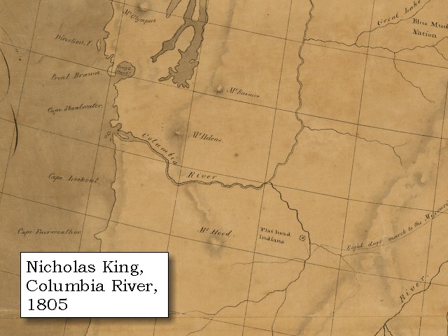
- 1805 Map, Pacific Northwest and the Columbia River (section of original). (Click to enlarge).
Includes the Columbia River, Mount Rainier, Mount St. Helens, and Mount Hood.
Original Map:
A map of part of the continent of North America : between the 35th and 51st degrees of north latitude,
and extending from 89o degrees of west longitude to the Pacific Ocean / compiled from the authorities
of the best informed travellers by M. Lewis ; copied by Nicholas King, 1805.
Notes: Map covers western North America, from Lake Michigan and Lake Superior to the Pacific Ocean, including southern Canada and northern
Mexico. Pen-and-ink and watercolor.
Note from map folder: Map was copied from a sketch by William Clark, not one by Meriwether Lewis as indicated in the title. Copy sectioned and mounted on cloth.
Library of Congress American Memory Archives #G3300 1805 .C5 Vault Oversize.
-- U.S. Library of Congress Archives, 2004, "American Memory"
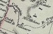
- 1814 Map, Lewis and Clark's map of the Columbia River (section of original). (Click to enlarge.)
Includes three of the five volcanoes Lewis and Clark saw and commented on. While the journals mention the expedition seeing Mount Adams, it does not appear on their map. Mount Jefferson is to the south (bottom) and off the map.
From the "Nicholas Biddle/Paul Allen" 1814 publication.
Original Map: "A Map of Lewis and Clark's Track, Across the Western Portion of North America, From the Mississippi to the Pacific Ocean".
From: History of the expedition under the command of Captains Lewis and Clark : to the sources of the Missouri, thence across the Rocky Mountains and down the river Columbia to the Pacific Ocean : performed during the years 1804-5-6 : by order of the government of the United States / prepared for the press by Paul Allen. Philadelphia : Bradford and Insskeep, 1814.
Harold B. Lee Library, Brigham Young University #upbover maps37.
-- Brigham Young University, Harold B. Lee Library Website, 2004.
- 1814 Map, Lewis and Clark's map of the Columbia River (section of original). (Click to enlarge.)
Map includes three of the five volcanoes Lewis and Clark saw and commented on. While the journals mention the expedition seeing Mount Adams, it does not appear on their map. Mount Jefferson is just visible to the south (bottom) and Mount Rainier is to the north but off the map.
From the "Nicholas Biddle/Paul Allen" 1814 publication.
Original Map: "A Map of Lewis and Clark's Track, Across the Western Portion of North America, From the Mississippi to the Pacific Ocean".
From: History of the expedition under the command of Captains Lewis and Clark : to the sources of the Missouri, thence across the Rocky Mountains and down the river Columbia to the Pacific Ocean : performed during the years 1804-5-6 : by order of the government of the United States / prepared for the press by Paul Allen. Philadelphia : Bradford and Insskeep, 1814.
Harold B. Lee Library, Brigham Young University #upbover maps37.
-- Brigham Young University, Harold B. Lee Library Website, 2004.
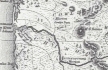
- 1833 Map (section of original), Columbia River. (Click to enlarge).
Includes Mount Hood and Mount Jefferson. Note: Mount Baker is depicted (upper middle) but Mounts Adams, Rainier and St. Helens are missing. The Columbia River is shown as "Oregon River" at its mouth and "Columbia or Oregon R." further inland. "Wappatoo Valley" is labeled. Also shows Fort Clatsop ("F. Clatsop or F. George"), the Willamette River ("Multnomah R."), Sandy River ("Quicksand R."), John Day River ("R.La Page"), Walla Walla River ("Wallwullah R."), Snake River ("Lewis R."), and the Yakima River ("Tapete R.").
Original Map: Oregon Territory, 1833.
Creator: Illman & Pilbrow, published by Illman & Pilbrow, New York.
Comments: Illman & Pilbrow is the engraving firm which copyrighted and published this map, the actual artist is unknown.
Washington State University Digital Maps Collection #WSU323.
University of Washington Digital Maps Collection #UW104.
-- Washington State University Early Washington Maps Digital Collection Website, 2004
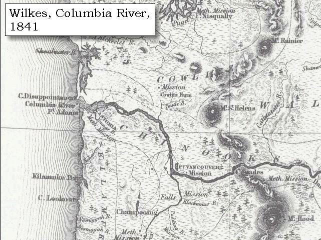
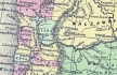
- 1841 Map (section of original), Columbia River, west. (Click to enlarge).
Includes Mount Rainier, Mount St. Helens, and Mount Hood. Mount Adams is depicted but not named.
From Wilkes, 1841, the U.S. Exploring Expedition.
-- Washington State University Early Washington Maps Digital Collection Website, 2004
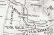
- 1853 Map, Washington and Oregon and the Columbia River,
from the Clearwater River to the Snake River and down the Columbia River to the Pacific Ocean (section of original). (Click to enlarge).
Includes: Clearwater River (Kooskooski), Lapwai Creek (Lapwai R.), Snake River (Saptin or Lewis R.), Columbia River (Columbia R.), Yakima River (Yakima R.), Walla Walla River (Wallawalla R.), Umatilla River (Umatilla R.), Willow Creek (Quesnells R.), John Day River (John Day's R.), Deschutes River (Fall R.), Willamette River (Willammette R.), and Cowlitz River (Cowlitz R.).
Original Map: "Map of California, Oregon, Washington, Utah, and New Mexico (1853)",
by Thomas Cowperthwait & Co.
Washington State University Archives #WSU22.
-- Washington State University Library Collections Website, 2003
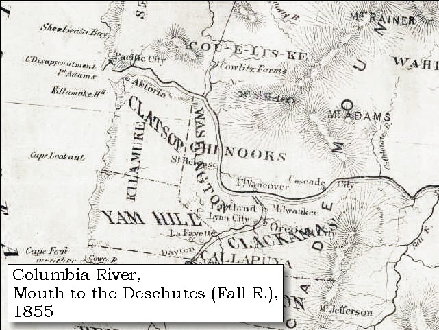
- 1855 Map, Columbia River from
Vancouver to the Pacific (section of original). (Click to enlarge).
Includes Mount Rainier, Mount St. Helens, Mount Adams, Mount Hood (depicted but not named), and Mount Jefferson.
Original Map: "Map of Oregon and Washington Territories:
showing the proposed Northern Railroad route to the Pacific Ocean,
by John Disturnell, 1855.
University of Washington Archives #UW155.
-- University of Washington Library Collections Website, 2002
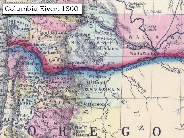
- 1860 Map, Columbia River, Washington State, and Oregon (section of original). (Click to enlarge).
Original Map: Map of Oregon, Washington, and British Columbia, (1860).
This map dates between March 2nd, 1861 (when the Dakota Territory was formed) and March 4th, 1863 (when the Idaho Territory was formed from eastern Washington and western Dakota)
Nearing retirement from a thirty year long and rather successful career, S. Augustus Mitchell printed this map showcasing Oregon, the Territory of Washington, and British Columbia. Washington became a territory in 1853, arguing that distances to Willamette Valley kept them from obtaining a voice in the Oregon territorial government. As this map shows, when it split from Oregon proper the Washington territory included parts of Wyoming and Montana and all of Idaho. Territorial government for Idaho would not be approved until 1863. When Mitchell retired he left the business for his son to manage.
Washington State University Archives #WSU7.
-- Washington State University Archives, 2004
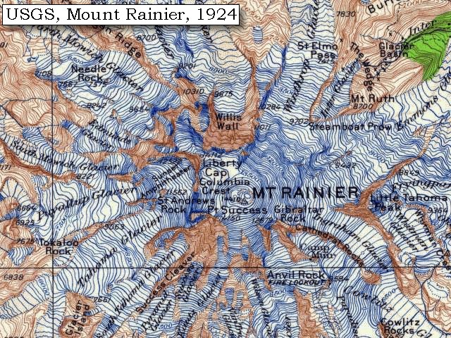
- 1924 Map of Mount Rainier (section of original), from Mount Rainier 1:125,000
topographic quadrangle. (Click to enlarge).
Original map surveyed in 1924, contour interval of 100 feet.
-- University of Washington Library Collections Website, 2004
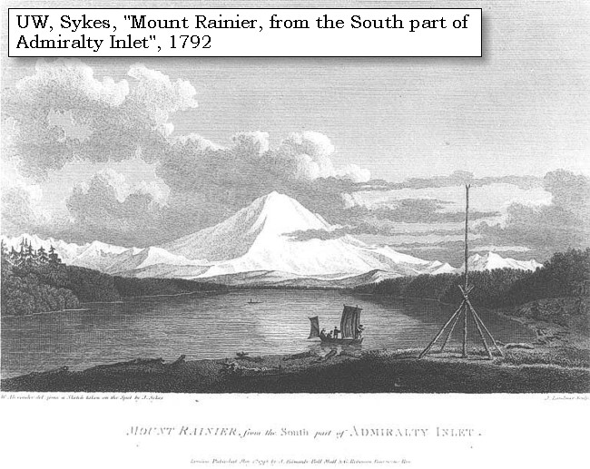
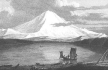
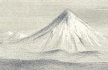
- 1792, Mount Rainier and Admiralty Inlet. (Click to enlarge).
Clallam pole for netting ducks, in front of Mount Rainier, Washington, in engraving made 1792 Original Creator: John Sykes.
Caption on image: W. Alexander det: from a sketch taken on the spot by J. Sykes. Mount Rainier, from the south part of Admiralty Inlet. London, published May 1st, 1798 by R. Edwards, New Bond Street, J. Edwards, Pall Mall, & G Robinson, Paternoster Row.
University of Washington Archives #NA3985.
-- University of Washington Archives, 2004
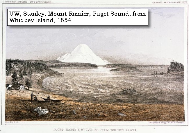
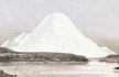
- 1854, Mount Rainier and Whidbey Island. (Click to enlarge).
Skagit men & canoes and Mount Rainier seen from Whidbey Island, Washington, in engraving made ca. 1854 Original Creator: Stanley, J. M. (John Mix), 1814-1872
Notes: Photograph of engraving of the Sound and Mt. Rainier from the shore, on shore are men with canoe (and buildings in background), in the sound is another canoe with men.
Note from unidentified source: Puget Sound and Mt. Rainier from Whitbey's [sic] Island
Image from U.S. War Dept.'s Reports of explorations and surveys to ascertain the most practicable and economical route for a railroad from the Mississippi River to the Pacific Ocean, 1860, v. 12, pt.1, pl.68.
University of Washington Archives #NA4173.
-- University of Washington Archives, 2004
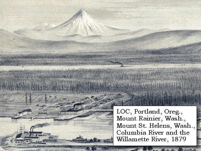
- 1879, Detail of engraving of Portland, Oregon and Mount Rainier and Mount St. Helens, Washington. (Click to enlarge).
The Columbia River is middleground with the Willamette River in the foreground.
Created by E.S. Glover. Published 1879, San Francisco.
"Bird's-eye-view", looking east to the Cascade
Mountains.
Original lithograph shows Mount Rainier, Mount St.
Helens, Mount Adams, and Mount Hood, and also the
Columbia River and the Willamette River.
Reference #LC Panoramic Maps #722.
--
Library of Congress American Memories Website, 2002
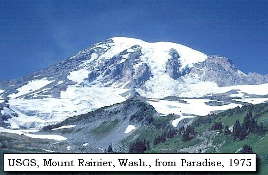
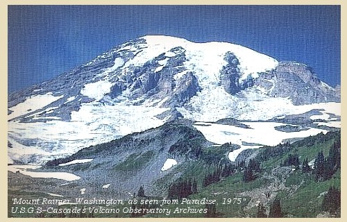
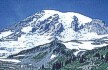
- 1975, USGS Photo showing Mount Rainier, Washington, from Paradise (Click to enlarge).
Photographer: Lyn Topinka, Date: 1975.
-- USGS Cascades Volcano Observatory Photo Archives, 2004
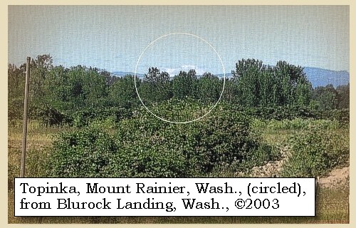
- 2003, Mount Rainier, Washington (circled), as seen from Blurock Landing, Washington. (Click to enlarge). Blurock Landing is across the Columbia River from the mouth of the Willamette River, Oregon. From this location Lewis and Clark spotted five volcanoes.
Copyright © 2003 Lyn Topinka, private archives, used with permission.
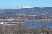
- 2004, Mount Rainier, Washington, as seen from near Rainier, Oregon. (Click to enlarge).
Copyright © 2004 Lyn Topinka, private archives, used with permission.
Excerpts from:
Sisson, 1995,
Swanson, et.al., 1989, and
U.S. National Park Service, Mount
Rainier National Park Website, 2002
|