|
October 30, 1805 "Lower Falls of the Columbia" - Dog Mountain to Cascade Locks |
|
Home
The Volcanoes of Lewis and Clark Map of the Journey Volcanoes, Basalt Plateaus, Major Rivers, etc. The Volcanoes Mount Adams, Mount Hood, Mount Jefferson, Mount Rainier, and Mount St. Helens CALENDAR of the Journey October 1805 to June 1806 Along the Journey Pacific Northwest Maps - Columbia River, Volcanoes, Flood Basalts, Missoula Floods, Geology, etc. The Corps of Discovery The Journey of Lewis and Clark About the Reference Materials The Journals, Biddle/Allen, DeVoto, Gass, Moulton, Topo Maps, and others USGS Lewis and Clark Links Links to USGS Websites highlighting the Lewis and Clark Journey Resources Publications Referenced and Websites Visited |
PREVIOUS
October 29 Entering the Columbia River Gorge, The Dalles to the Little White Salmon |
October 30
"Lower Falls of the Columbia", Dog Mountain to Cascade Locks Dog Mountain Landslide, Four Cascades, Submerged Forest, Wind River, Stevenson (Washington), "Lower Falls of the Columbia" and Cascade Locks |
CONTINUE
October 31 "Lower Falls of the Columbia", Cascade Locks - Preparing to Portage |
On October 7, 1805, Lewis and Clark and the
"Corps of Discovery" began their journey
down the Clearwater River and into the volcanics
of the Pacific Northwest. The Corps travelled from the
Clearwater to the Snake and down the
"Great Columbia", finally reaching the
Pacific Ocean on November 15, 1805.
Along the journey they encountered the
lava flows of the Columbia Plateau,
river channels carved by the great "Missoula Floods",
and the awesome beauty of five Cascade Range volcanoes.

[Click map for brief summary about the area] |
|
To the Pacific - October 1805
"Lower Falls of the Columbia" - Dog Mountain to Cascade Locks |
| Lewis and Clark camped on the Washington side of the Columbia, upstream of the Little White Salmon River, at a village near a "Pond". Today the Washington town of Cook is located at the mouth of the Little White Salmon River. |
| Wednesday, October 30, 1805 |
| A moderate rain fell during all last night, but the morning was cool, and after taking a scanty breakfast of deer, we proceeded. The river is now about three quarters of a mile wide, with a current so gentle, that it does not exceed one mile and a half an hour; [passing location of Viento State Park, Oregon, on the left] but its course is obstructed by the projection of large rocks, which seemed to have fallen promiscuously from the mountains into the bed of the river. [possibly Dog Mountain Landslide] |
| "... passed Several places where the rocks projected into the river & have the appearance of haveing Seperated from the mountains and fallen promiscuisly into the river, Small nitches are formed in the banks below those projecting rocks which is comon in this part of the river, ..." [Clark, October 30, 1805] |
|
|
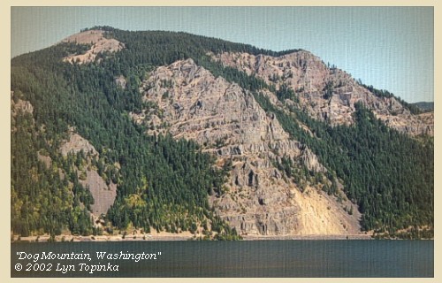
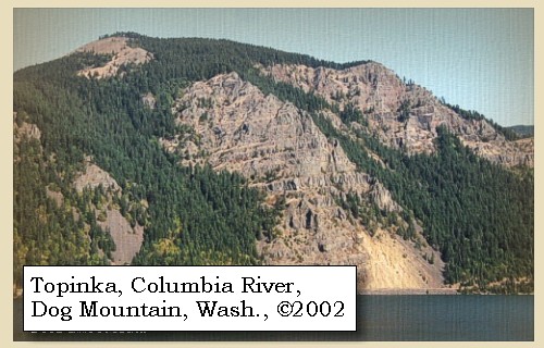
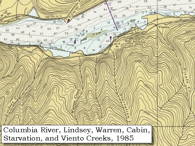
Dog Mountain Landslide: Local landslides, some taking place as recently as 200 years ago, have occurred in several areas along the Columbia River. The large Bonneville landslide, between the cities of North Bonneville and Stevenson, exposed the Red Bluffs [See Bonneville Landslide, October 31, 1805 entry]. The landslide, which consists chiefly of the Eagle Creek Formation and Yakima Basalt, blocked the Columbia River for a short period. Another landslide between Wind Mountain and Dog Mountain consists chiefly of material from the Ohanapecosh Formation. This landslide is still active. It moves 40 to 50 feet a year at the upper end of the slide and 5 to 10 feet a year at the toe. -- U.S. Forest Service Website, 2002, Gifford Pinchot National Forest 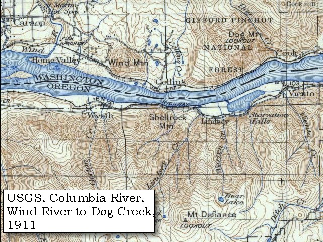
|
| On the left side four different streams of water empty themselves in cascades from the hills. |
| "... Saw 4 Cascades caused by Small Streams falling from the mountains on the Lard. Side, ..." [Clark, October 30, 1805] |
| The possiblities in this area are Starvation Creek and Falls, the seasonal Cabin Creek and Falls, Warren Creek and Falls, and Wonder Creek and Lancaster Falls. Lindsey Creek and Falls is another one half mile further west. |
|
|
|
Four Cascades:
The possiblities in this area are (upstream to downstream) Starvation Creek and Falls, the seasonal Cabin Creek and Falls (depicted but unnamed on these maps), Warren Creek and Falls, and Wonder Creek and Lancaster Falls (not depicted on these maps). Lindsey Creek and Falls is another one half mile further west, and Viento Creek is upstream. 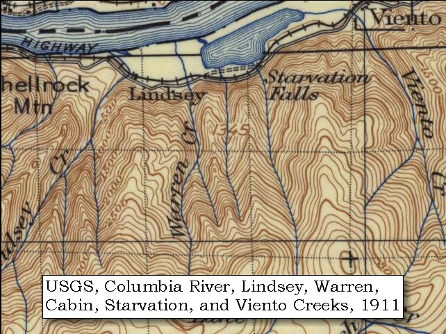
|
| What is, however, most singular is, that there are stumps of pine trees scattered to some distance in the river, which has the appearance of being dammed below and forced to encroach on the shore: |
| "... This part of the river resembles a pond partly dreaned leaving many Stumps bare both in & out of the water, current about 1 mil pr. Hour ..." [Clark, October 30, 1805, first draft] |
| "... a remarkable circumstance in this part of the river is, the Stumps of pine trees are in maney places are at Some distance in the river, and gives every appearance of the rivers begin damed up below from Some cause which I am not at this time acquainted with, the Current of the river is also verry jentle not exceeding 1 1/2 mile pr. hour and about 3/4 of a mile in width. ..." [Clark, October 30, 1805] |
|
|
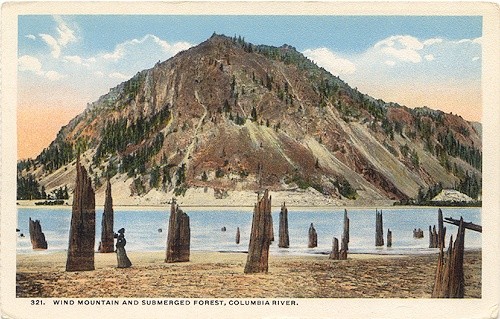
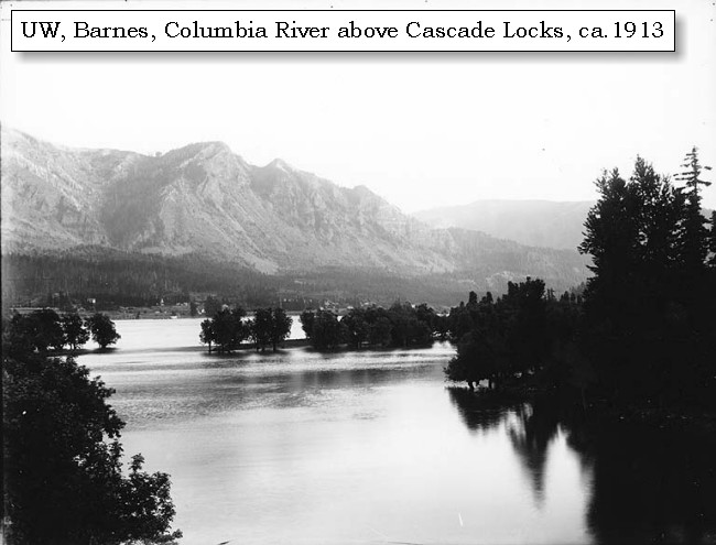
The Submerged Forest: According to Professor John Allen of Portland State University (1983):" Up until the completion of Bonneville Dam in 1938, a ghostly white forest of drowned tree stumps could be observed along both sides of the Columbia River between Cascade Locks and The Dalles. The submerged forest was first mentioned in a geologic textbook in 1853, in 'Principles of Geology' by Sir Charles Lyell: 'Thus Captains Clark and Lewis found, about the year 1807 (sic), a forest of pines standing erect under water in the body of the Columbia RIver, which they supposed, from the appearnace of the trees, to have been submerged only about twenty years.' Both Lewis and Clark in 1805 and Captain Fremont in 1845 recognized that the trees were drowned by the formation of a lake behind a 200-foot landslide dam. Possibly triggered by an earthquake, the dam material slid down from the cliffs of Table Mountain and Greenleaf Peak at a time later determined to be between 1260 and 1290 A.D. The stumps were described in detail by Minnesota biologists Donald B. and Elizabeth G. Lawrence in a series of definitive papers in 1935, 1937, 1937, and 1958. The Lawrences were the first to date the time of the landslide, by caron 14 analyses, as having occurred 700 years before. As of 1936, the Lawrence's counted 3,068 stumps on the south side of the river, and 938 on the north side of the river. The maximum concentration of stumps on the south side occurs just above the mouth of Viento Creek, where more than 800 stumps were counted within a small area.: -- Allen, 1983, Time Travel in Oregon 
|
| these obstructions continue till at the distance of twelve miles, when we came to the mouth of a river on the right [Wind River], where we landed: we found it sixty yards wide [Wind River], and its banks possess two kinds of timber which we had not hitherto seen: one is a very large species of ash; the other resembling in its bark the beach; but the tree itself, as also the leaves, are smaller. We called this stream Crusatte's river [Wind River], after Crusatte, one of our men: opposite to its mouth the Columbia widens to the distance of a mile, with a large sandbar, and large stones and rocks scattered through the channel. ...... |
| "... Some rain, we landed above the mouth of a Small river on the Stard. Side and Dined. ... here the river widens to about one mile large Sand bar in the middle, a Great both in and out of the water, large Stones, or rocks are also permiscuisly Scattered about in the river ... The bottoms above the mouth of this little river (which we Call) is rich covered with grass& firn & is about 3/4 of a mile wide rich and rises gradually, below the river (which is 60 yards wide above its mouth) the Countery rises with Steep assent. we call this little river (fr Ash) New Timbered river from a Speces of Ash (that wood) which grows on its banks of a verry large and different from any we had before Seen ..." [Clark, October 30, 1805] |
|
|
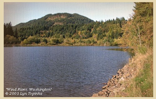
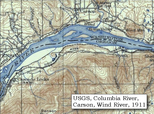
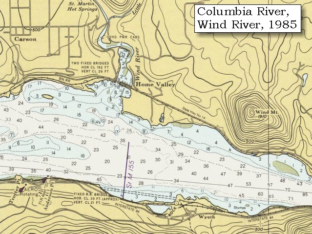
Wind River: Wind River basin, located in southwestern Washington, originates in McClellan Meadows in the western Cascades and enters Bonneville Reservoir at River Mile (RM) 154.5 near Carson, Washington. Wind River drains approximately 225 square miles over a distance of 31 miles. Principle tributaries to Wind River include Little Wind River, Bear, Panther, Trout, Trapper, Dry, Nineteenmile, Falls and Paradise creeks. The basin is oriented northwest to southeast with elevations ranging from 80 to 3,900 feet. Topography varies within the watershed; it is steep in the northwest and lower southeast, gentle in the northeast - McClellan Meadows area, and it is benchy in Trout Creek Flats and middle portions of the Wind River Valley. The mainstem of the Wind River drops 3,820 feet for an average gradient of 2.3 percent. Shepherd Falls, located at RM 2.0, is a series of four falls ranging from 8 to 12 feet that were a barrier to all anadromous salmonids except steelhead until the construction of a fish ladder in 1956. Originally Lewis and Clark called this river the "New Timber River". The name was later changed to "Crusats River," after a member of the corps, Pierre Cruzatte, when Captain Clark realized that Cruzatte was the only member of the corps who had not been honored with a place name on the westbound journey. He changed the name on the route map and course distance log, correcting the oversight. The present descriptive name was given by Isaac Stevens in 1853. The Wind River watershed has been shaped through 25 million years of volcanic activity and glacial action. Most of the watershed was formed 12 and 25 million years ago with some younger flows out of Indian Heaven and Trout Creek Hill being dated between 350,000 to three million. The majority of the watershed is in the older volcaniclastic material. -- Columbia Basin Fish and Wildlife Authority Website, 2002, and Washington State Historical Society Website, 2002 

|
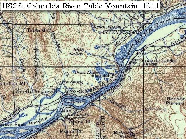
| Above Crusatte's river [Wind River] the low grounds are about three quarters of a mile wide, rising gradually to the hills, and with a rich soil covered with grass, fern, and other small undergrowth; but below, the country rises with a steep ascent, and soon the mountains approach to the river with steep rugged sides, covered with a very thick growth of pine, cedar, cottonwood, and oak. The river is still strewed with large rocks. Two and a half miles below Crusatte's river [Wind River] is a large creek [Rock Creek] on the right, with a small island in the mouth. [today, the location of Stevenson, Washington] |
|
|
|
Stevenson, Washington:
While fur trade was the first great incentive for coming to the Columbia River Gorge, it was the Donation Land Claim Law of 1850, and later the Homestead Act (which allowed people to obtain title to land), that brought settlers. Cutting wood for the wood-burning steamships which traversed the Columbia River was the first occupation in Skamania County and the Stevenson, Washington area. Commercial fishing for salmon and sturgeon, lumbering and farming soon followed. Logging and lumber mills became the mainstay of the County's economy until the early 1990's. The earliest saw mills date back to the mid-1850's. The Bradford Brothers, Daniel and Putnam, built a mill on their donation land claim west of Stevenson at Ashes Lake and Felix G. Iman had a mill west of Rock Creek in Stevenson. Today there is only one plywood or lumber mill within the County. The town of Stevenson is located on the Henry Shepard Donation Land Claim. George Stevenson bought a portion of the Shepard land in 1893 and laid out the original town site. -- Skamania County Chamber of Commerce Website, 2004 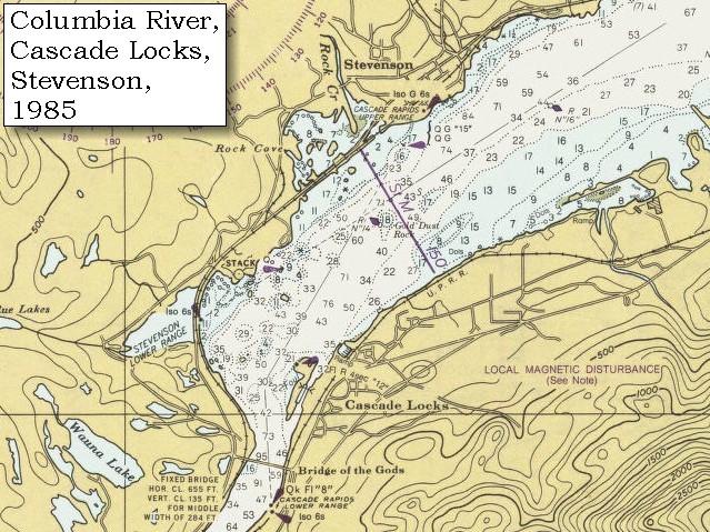
|
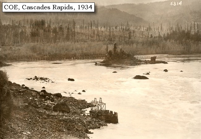
| Just below this creek [Rock Creek] we passed along the right side of three small islands on the right bank of the river, with a larger island on the opposite side, and landed on an island [???] very near the right shore at the head of the great shoot [The Cascade Rapids, today the location of the Cascade Locks], and opposite two smaller islands at the fall or shoot itself. |
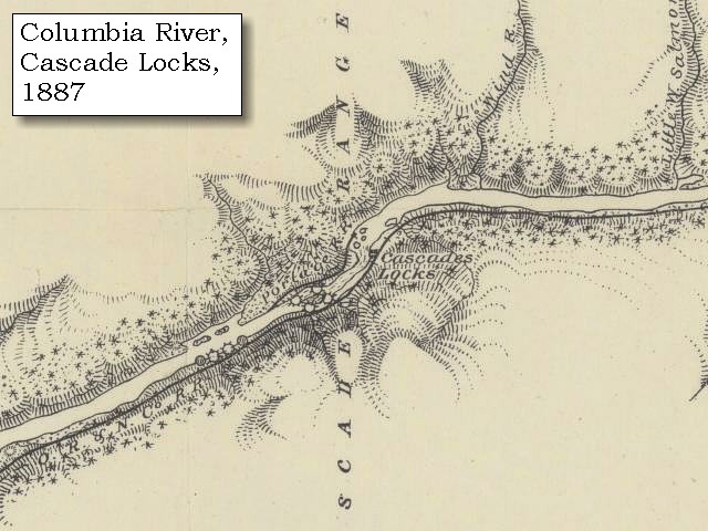
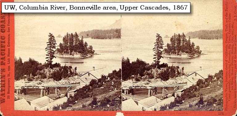
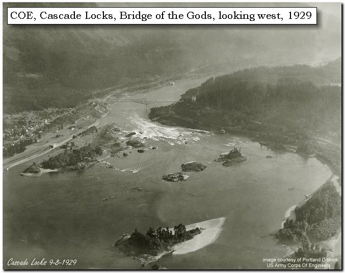
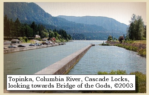
| Lewis and Clark have arrived at "The Lower Falls of the Columbia", an area also known as the Cascade Rapids, and today the vicinity of Cascade Locks, Oregon. In 1896 the Federal Government built a series of locks around the trecherous rapids. |
|
|
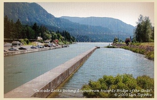
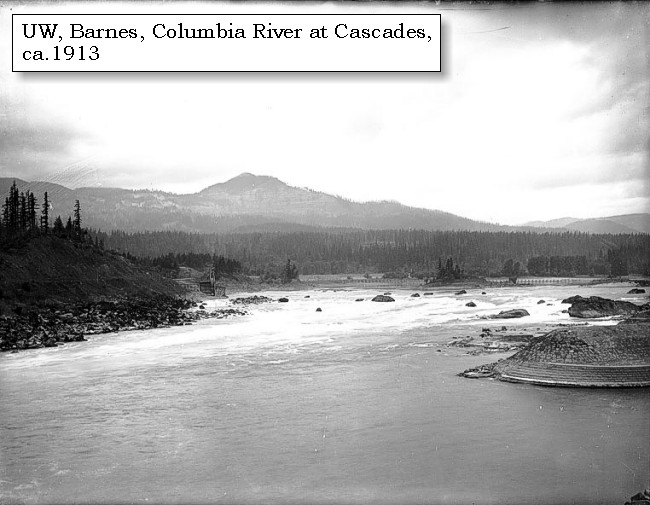
"Lower Falls of the Columbia" and Cascade Locks: Lewis and Clark called the area around today's Cascades Locks "the Lower Falls of the Columbia" -- the Celilo Falls area was known as the "Great Falls of the Columbia". Throughout time, the area became known as the "Cascades", and in 1825, John Work of the Hudson's Bay Company was the first to record the place name, "Cascades," to describe these falls in the Columbia. Four and a half miles long, the Cascades of the Columbia were separated into two sections. The first made a bend around a rocky point on the Oregon shore, then went into a 2,000-foot-long pitch in the river and a 21-foot drop. This was called the Upper Cascade. The rest of the contracted waterway, the Lower Cascade, was a long three-and-a-half-mile pitch in the river. The total fall of the river from the head of Upper Cascade to the bottom of Lower Cascade was 45 feet at high water and 36 feet at low water. Lewis and Clark first portaged around the "Lower Falls of the Columbia" in 1805, on their journey to the Pacific. Forty years later the pioneers traveling the water route on the Oregon Trail made the same portage. In 1850 a road was built on the north side of the Columbia to portage around the rapids, and a small settlement developed to help travelers around the rapids, first by foot and then by mule-drawn rail cars. In 1864, the first steam engine in the Northwest carried passengers and freight past the rapids. In 1896 a 3,000-foot-long navigational canal with locks was completed and the modern-day town of Cascade Locks developed. The Cascades and the early locks were flooded by backwater from Bonneville Dam in 1937. -- "www.cascadelocks.net" Website, 2004, and Washington State Historical Society Website, 2004, "Lasting Legacy". 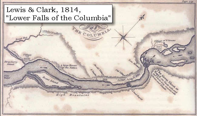


|
| Just above the island on which we were encamped [today this island is underwater] is a small village of eight large houses in a bend on the right, where the country, from having been very mountainous, becomes low for a short distance. We had made fifteen miles to-day, during all which time we were kept constantly wet with the rain. ...... As soon as we landed, captain Lewis went with five men to the village, which is situated near the river, with ponds in the low grounds behind: the greater part of the inhabitants were absent collecting roots down the river: the few, however, who were at home, treated him very kindly, and gave him berries, nuts, and fish; and in the house were a gun and several articles which must have been procured from the whites; but not being able to procure any information, he returned to the island. Captain Clarke had in the meantime gone down to examine the shoot [The Lower Falls of the Columbia], and to discover the best route for a portage. He followed an Indian path, which, at the distance of a mile, led to a village on an elevated situation ...... After going about three miles the night obliged him to return to camp: he resumed his search in the morning. |
|
|
|
The Camp - October 30 and 31, 1805:
Lewis and Clark's camp of October 30 and 31, 1805, was on an island on the Washington side of the Columbia River, above the Cascade Locks just north of today's Bridge of the Gods. This island is now under water. On the return trip home, Lewis and Clark stayed just south of here on April 12, 1806. |
| Home | Previous | Continue |
If you have questions or comments please contact: GS-CVO-WEB@usgs.gov
June/July 2004, Lyn Topinka
The Volcanoes of Lewis and Clark Home Page | CVO Home Page