Eruptions of Mount St. Helens and Mount Rainier
November 23, 1842 * and November 1843
|
[November 14, 1843]
... Wherever we came in contact with the rocks of these mountains, we found them volcanic, which is probably the character of the range; and at the time, two of the great snowy cones, Mount Regnier** and St. Helens, were in action. On the 23d of the proceeding November, St. Helens had scattered its ashes, like a light fall of snow, over the Dalles of the Columbia, 50 miles distant. A specimen of these ashes was given to me by Mr. Brewer, one of the clergymen at the Dalles. ...
|
* * * * * * * * * * * * * * * * * * * * * * * * *
Volcanoes of J.C. Fremont
Cascade Range, 1843
Mount Hood:
[October 23, 1843]
... The morning was very clear; there had been a heavy white frost during the night ...
The trail now led along one of the long spurs of the mountain [Blue Mountains], descending gradually towards the plain; and after a few miles travelling, we emerged finally from the forest, in full view of the plain below, and saw the snowy mass of Mount Hood, standing high out above the surrounding country, at the distance of 180 miles. The road along the ridge was excellent, and the grass very green and good; the old grass having been burnt off early in the autumn. About 4 o'clock in the afternoon we reached a little bottom on the Walahwalah river ...
[October 28, 1843]
...
Having reinforced our animals with eight fresh horses, hired from the post [Fort Nez Perce, located where the Walla Walla River meets the Columbia River] and increased our stock of provisions with dried salmon, potatoes, and a little beef, we resumed our journey down the left bank of the Columbia ... The sketch of a rock which we passed in the course of the morning is annexed, to show the manner in which the basaltic rock, which constitutes the geological formation of the Columbia valley, now presents itself [Twin Sisters]. From an elevated point over which the road led, we obtained another far view of Mount Hood, 150 miles distant. ...
Mount St. Helens (Mount Adams):
[October 29, 1843]
... The road continued along the river, and in the course of the day Mount St. Helens, another snowy peak of the Cascade range, was visible [probably Mount Adams]. We crossed the Umatilah river at a fall near its mouth. This stream is of the same class as the Walahwalah river, with a bed of volcanic rock, in places split into fissures. ...
Mount Hood:
[October 31, 1843]
... The early morning was very clear, and the stars bright; but, as usual since we are on the Columbia, clouds formed immediately with the rising sun. The day continued fine, the east being covered with scattered clouds, but the west remaining clear; showing the remarkable cone-like peak of Mount Hood brightly drawn against the sky. This was in view all day in the southwest, but no other peaks of the range were visible. ...
[November 1, 184]
... Mount Hood is glowing in the sunlight this morning, and the air is pleasant ...
Mount Hood and Mount St. Helens:
[November 7, 1843 ... or the 8th ???]
... After an early breakfast, at daylight we resumed our journey, the weather being clear and beautiful, and the river smooth and still [Fremont has left his group and is in a canoe journeying down the Columbia River to Fort Vancouver]. On either side the mountains are all pine-timbered, rocky, and high. We were now approaching one of the marked features of the lower Columbia, where the river forms a great cascade [today the Bonneville Dam/Cascade Locks area], with a series of rapids, in breaking through the range of mountains to which the lofty peaks of Mount Hood and St. Helens belong, and which rise as great pillars of snow on either side of the passage. The main branch of the Sacramento river, and the Tlamath, issue in cascades from this range; and the Columbia, breaking through it in a succession of cascades, gives the idea of cascades to the whole range; and hence the name of the CASCADE RANGE, which it bears, and distinguishes it from the Coast Range lower down. In making a short turn to the south, the river forms the cascades in breaking over a point of agglomerated masses of rock, leaving a handsome bay to the right, with several rocky pine-covered islands, and the mountains sweep at a distance around a cove where several small streams enter the bay. In less than an hour we halted on the left bank, now about five minutes walk above the cascades, where there were several Indian huts, and where our guides signified it was customary to hire Indians to assist in making the portage. ... This portage makes a head of navigation, ascending the river. It is about two miles in length; and above, to the Dalles, is 45 miles of smooth and good navigation.
We glided on without further interruption between very rocky and high steep mountains, which sweep along the river valley at a little distance, covered with forests of pine, and showing occasionally lofty escarpments of red rock. Nearer, the shore is bordered by steep escarped hills and huge vertical rocks, from which the waters of the mountain reach the river in a variety of beautiful falls, sometimes several hundred feet in height. Occasionally along the river occurred pretty bottoms, covered with the greenest verdure of the spring. ... A few miles below the cascades we passed a singular isolated hill [Beacon Rock]; an in the course of the next six miles occurred five very pretty falls from the heights on the left bank, one of them being of a very picturesque character [possibly Multnomah Falls]; an towards sunset we reached a remarkable point of rocks, distinguished, on account of prevailing high winds, and the delay it frequently occasions to the canoe navigation, by the name of Cape Horn. ...
Mount Rainier and Mount St. Helens:
[November 13, 1843]
... We had a day of disagreeable and cold rain; and, let in the afternoon, began to approach the rapids of the cascades. ...
[November 14, 1843]
... Crossing to the right bank, we cordelled the boat along the shore, there being no longer any use for the paddles, and put into a little bay below the upper rapids. ...
The masses of rock displayed along the shores of the ravine in the neighborhood of the cascades are clearly volcanic products. Between this cover, which I called Grave-yard bay, and another spot of smooth water above, on the right, called Luders bay, sheltered by a jutting point of huge rocky masses at the foot of the cascades, the shore along the intervening rapids is lined with precipices of distinct strata of red and variously colored lavas, in inclined positions.
The masses of rock forming the point at Luders bay consist of a porous trap, or basalt -- a volcanic product of a modern period. ...
Wherever we came in contact with the rocks of these mountains, we found them volcanic, which is probably the character of the range; and at the time, two of the great snowy cones, Mount Regnier** and St. Helens, were in action. On the 23d of the proceeding November, St. Helens had scattered its ashes, like a light fall of snow, over the Dalles of the Columbia, 50 miles distant. A specimen of these ashes was given to me by Mr. Brewer, one of the clergymen at the Dalles.
The lofty range of the Cascade mountains forms a distinct boundary between the opposite climates of the regions along its western and eastern bases. On the west, they present a barrier to the clouds of fog and rain which roll up from the Pacific ocean and bent against their rugged sides, forming the rainy season of the winter in the country along the coast. Into the brighter skies of the region along their eastern base, this rainy winter never penetrates; and at the Dalles of the Columbia the rainy season is unknown, the brief winter being limited to a period of about two months, during which the earth is covered with the slight snows of a climate remarkably mild for so high a latitude. The Cascade range has an average distance of about 140 miles from the sea coast. It extends far both north and south of the Columbia, and is indicated to the distant observer, both in course and position, by the lofty peaks which rise out of it, and which are visible to an immense distance.
Mount Hood:
[November 17, 1843]
... About 4 o'clock in the afternoon we passed a sandy bar in the river, whence we had an unexpected view of Mount Hood, bearing directly south by compass. ...
Mount Rainier, Mount St. Helens, and Mount Hood (Mount Adams ???):
[November 18, 1843]
... At 10 o'clock we passed a rock island, on the right shore of the river, which the Indians use as a burial ground; and, ... early in the afternoon we arrived again at the Dalles. ...
[from the mission at the Dalles]
...
We made ... several excursions in the vicinity. Mr. Perkins walked with Mr. Preuss and myself to the heights, about nine miles distant, on the opposite side of the river, whence, in fine weather, an extensive view may be had over the mountains, including seven great peaks of the Cascade range; but clouds, on this occasion, destroyed the anticipated pleasure, and we obtained bearings only to three that were visible; Mount Regnier, St. Helens, and Mount Hood [could Mount Regnier or St. Helens possibly be Mount Adams ???]. On the heights, about one mile south of the mission, a very fine view may be had of Mount Hood and St. Helens. In order to determine their positions with as much accuracy as possible, the angular distances of the peaks were measured with the sextant, at different fixed points from which they could be seen. ...
[November 26, 1843 ... the party is heading home, via The Dalles to the Deschutes to southern Oregon and onward]
...
Left camp at 10 o'clock, the road leading along tributaries of the Tinanens, and being, so far, very good. ... This morning we had a grand view of St. Helens and Regnier: the latter appeared of conical form, and very lofty, leading the eye far up into the sky [perhaps Mount Adams ???]. The line of the timbered country is very distinctly marked here, the bare hills making with it a remarkable contrast. The summit of the ridge commanded a fine view of the Taih prairie, and the stream running through it, which is a tributary to the Fall river [Deschutes], the chasm of which is on the right. ...
Mount Hood and Mount Jefferson:
[November 27, 1843]
...
A fine view of Mount Hood this morning; a rose-colored mass of snow, bearing S. 85? W. by compass. The sky is clear, and the air cold; the thermometer 2?.5 below zero; the trees and bushes glittering white, and the rapid stream filled with floating ice ... we resumed our journey at 10 o'clock. We ascended by a steep hill from the river bottom, which is sandy, to a volcanic plain, around which lofty hills sweep in a regular form. It is cut up by gullies of basaltic rock, escarpments of which appear every where in the hills. This plain is called the Taih prairie, and is sprinkled with some scattered pines. The country is now far more interesting to a traveler than the route along the Snake and Columbia rivers. To our right we had always the mountains, from the midst of whose dark pine forests the isolated snowy peaks were looking out like giants. They served us for grand beacons to show the rate at which we advanced our journey. Mount Hood was already becoming an old acquaintance, and, when we ascended the prairie, we obtained a bearing to Mount Jefferson, S. 23? W. The Indian superstition has peopled these lofty peaks with evil spirits, and they have never yet known the tread of a human foot. Sternly drawn against the sky, they look so high and steep, so snowy and rocky, that it would appear almost impossible to climb them; but still a trial would have its attractions for the adventurous traveler. ...
[November 29, 1843]
...
We emerged from the basin, by a narrow pass, upon a considerable branch of Fall river, running to the eastward through a narrow valley. The trail, descending this stream, brought us to a locality of hot springs, which were on either bank ... We crossed the stream here, and ascended again to a high plain, from an elevated point of which we obtained a view of six of the great peaks -- Mount Jefferson, followed to the southward by two others of the same class; and succeeding, at a still greater distance to the southward, were three other lower peaks, clustering together in a branch ridge. These, like the great peaks, were snowy masses, secondary only to them; and, from the best examination our time permitted, we are inclined to believe that the range to which they belong is a branch from the great chain which here bears to the westward. ...
|
* Harry M. Majors, writing about the 1842-1844 eruptions of Mount St. Helens (Northwest Discovery, July 1980), suspects this date to be November 25, 1842.
**
George Gibbs, published in 1873, states Fremont in error about Mount Rainier, that it was Mount Baker in eruption.
* * * * * * * * * * * * * * * * * * * * * * * * *
Details of Maps, The Fremont Expedition
published 1845
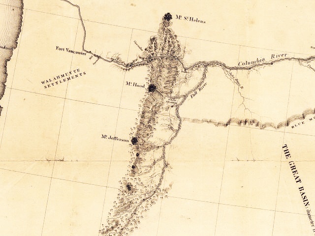
Section of John C. Fremont's Map, depicting the Columbia River and the Cascade Range.
Volcanoes labeled are Mount St. Helens, Mount Hood, and Mount Jefferson.
Note Three-Fingered Jack, Mount Washington, and the Three Sisters volcanic peaks in the lower half of the image. Fort Vancouver is today's Vancouver, Washington, Fall River is today's Deschutes River, and John Day's River is now known as simply John Day River. Note the Blue Mountains on the middle right.
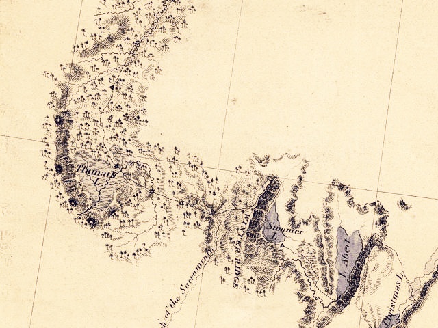
Section of John C. Fremont's Map, showing four peaks around Klamath Lake, Oregon.
-- Maps courtesy U.S. Library of Congress Archives Website, 2003. Original map information is: Map of an exploring expedition to the Rocky Mountains in the year 1842 and to Oregon & north California in the years 1843-44 / by Brevet Capt. J.C. Fr?mont of the Corps of Topographical Engineers under the orders of Col. J.J. Abert, Chief of the Topographical Bureau ; lith. by E. Weber Co., Baltimore, Md., 1845
|
|