...
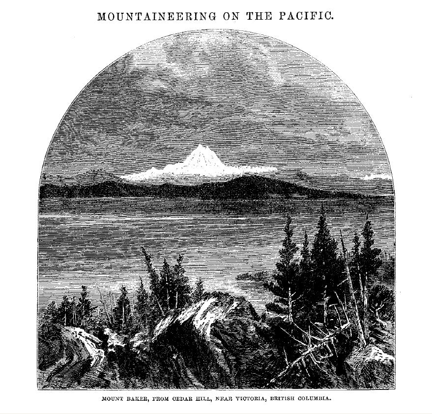
Mount Baker is the most northerly of those great cones which dot the Cascade range, and is only fourteen miles south of the great boundary line cut through the forests which divide the American and English possessions. It forms the most striking feature in the attractive scenery around the Fuca Straits and the Puget Sound. Amidst numerous groups of islands (the Western Cyclades) and pine-clad heights, like another "Snowy Olympus," it towers above, the silent sentinel of a solitary land.
...
The mountain may be approached on the southeastern side by the Skadgett River, taking Utsalady, on Puget Sound, as the starting point; on the western side by the river Lummi, which flows into Bellingham Bay, taking Seahome as the starting-point; and on the northern side by a trail from Fraser River, taking Fort Hope as the starting-point. The first approach was chosen for the initial attempt, which was made in company with Charles B. Darwin, Judge of the District Court of the United States, and Dr. Robert Brown, of Edinburgh. We then arrived at a point about fifty miles up the Skadgett, when, owing to the opposition offered by an unfriendly tribe of Indians, the journey was abandoned. For the next attempt the second approach, by the Lummi River, was selected,
...
On this occasion Messrs. Tennent and Bennett, enterprising settlers in the district, joined in, and we reached a point near the summit; but were compelled to return by reason of an overhanging cornice of ice which barred the way, and the fact that we had neither sufficient time nor provisions to make another attempt. In the following year the utmost exertions were unable to get up a party; but next year the author was encouraged to proceed by the willingness of Mr. Thomas Stratton, Inspector of Customs at Port Townsend, Mr. Tennent, and Mr. David Ogilvy, of Victoria, to accompany him, when the approach by the Lummi was again chosen. General M'Kenny, Superintendent of Indian Affairs for Washington Territory, kindly placed four trustworthy Indians at my command.
...
Sure of such good company, I determined to start from Victoria on 4th August 1868.
...
On the morning of the 16th we found the fog had cleared away. The summit was now seen for the first time, lying to the north of the two peaks already mentioned [Lincoln and Colfax Peaks]. I called my companions, and directed their attention to the path I proposed to take. From this point it looked fearfully precipitous, and they doubtfully shook their heads. They followed up, however,
...
In rather less than two hours we reached our last encampment near the "neve".
...
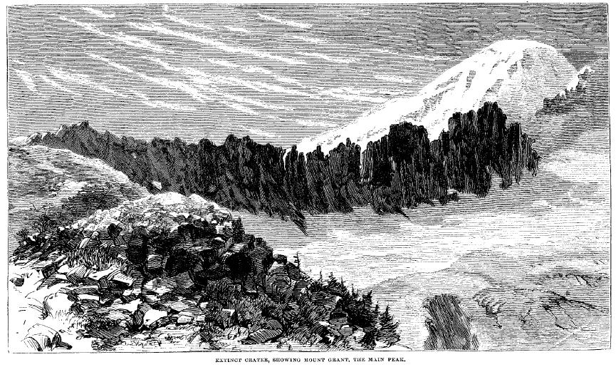
We encamped on a spot 7054 feet high, where the trees formed a semicircle round a small volcanic rock. The ground was covered with grass and heather, and sheltered by the trees from the cold winds of the glaciers. To the southeast is a vast snow-field, stretching perhaps 2000 feet beneath, and terminating in a glacier. Below this glacier, and only separated from it by "moraines," is a lovely valley with open land covered with grass and sheltered by pines.
...
Thousands of feet above the snow-field, rose on every side black, jagged, splintered precipices. Of these the Lincoln Peak is from this point of view the most prominent. A little further east is the Colfax Peak, and beyond that, due east, is the summit itself. The ridge on which we were encamped is two miles in length; it sweeps first round to the north, then to the east, intersecting another ridge running down from the Colfax Peak. These ridges are evidently the walls of an extinct crater, whose vast hollow is some two miles in length by about the same in width. At the point of intersection of the above-mentioned ridges, but beyond it (a vast field of neve filling the intervening space), rises the great peak, entirely snow-covered.
...
Next morning [August 17] we started at five, and about half past six came to the end of the ridge (about two miles). Here we put on our creepers and spiked boots, made several packs, and took provisions for twenty-four hours. In facct, we prepared to pass the night out if need be. The Indians bade us farewell
...
To avoid the avalanches descending form the Colfax Peak on the one hand, and from the "Grant" or main peak on the other, we kept on through the middle of this vast tract of neve.
...
Soon after we had reached the shoulder leading to the great peak we came to a narrow ridge, about four feet in height, composed of reddish scoria. From this point we saw a glacier flowing down through a deep and narrow gorge on the southern side of the Colfax Peak, having its origin in the snows of that peak. This I propose to name M'Kenny's Glacier, after General M'Kenny, Superintendent of Indian Affairs for Washington Territory. We were also able to see the head of another glacier extending in an easterly direction, and fed by the snows of the Grant or main peak. This was named the Frontin Glacier, in honor of a lady who, on the occasion of the previous journey, made me a beautiful flag of the Stars and Stripes, to be placed on the highest spot attained. It was here, on that occasion, that Mr. Bennettt and myself passed a miserable night
...
The last three or four hundred feet of the route lies over a deposit resembling mud; it was quite dry in parts and cracked from the action of the sun. At length we reached the top of the saddle and stood on the base of the principal peak.
...
If we had indulged any doubt of this being a volcanic mountain, it would have been dispelled by the smell of sulphurous exhalation which greeted us. So nauseous was it that Stratton had vomited while waiting for us.
At this point the base proper of the peak may be said to commence. On our right, across a hollow filled with "neve," is the lip of the crater, indicated by a huge triangular-shaped rock; and on our left are tremendous precipieces extending down to the track of "neve" we had traversed in the morning. Around the summit of the peak is a perpendicular wall of ice about thirty or forty feet in height, terminated on the left or northern end by a knuckle of rock, which can be plainly seen from the Sound. The only passage we could discern through this barrier is on the left, between the knuckle of rock before-mentioned and the wall of ice. The face of the peak is scored with deep furrows, made by the avalanches of ice which have fallen from the summit. The peak rises about 1000 feet higher. It commences with a gentle slope, and gradually becomes steeper, until near the summit it is about 60o.
Roping ourselves together, we now attempted this
...
As precipices extended downward from our feet, a single false step would have been fatal. In safety, however, we passed the most dangerous point, and reached the passage, which, by a gentle ascent of 30 or 40 feet, brought us to the summit.
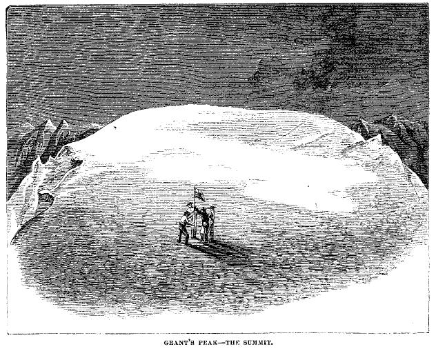
It was now four o'clock. We had been two hours making this final climb. The plateau on which we stood was about a quarter of a mile in diameter, and embraced an extent of about eighty acres. The scene was grand in the nakedness of its desolation. The white surface of snow was unrelieved by a single rock. The forests had been on fire for weeks, and a dense pall of smoke veiled the surrounding scenery from our view. It lay like a reddish cloud beneath us. We felt cut off from the world we had left. Overhead the sun poured down his bright beams from a sky which formed a dome of purplish blue, unsullied by a cloud.
...
We now advanced to the centre of the plateau, and all laying hold of the flag-staff bearing the Stars and Stripes we planted it firmly in the snow, and named the peak after General Grant. Immediately after we sang an appropriate patriotic song. We then shook hands, and, a flask of brandy being produced, the names of all those interested in the expedition were duly honored.
There was a peculiarity in the snow which covered this plateau that I have not observed in the Alps. In form it resembled small tongues of flame, all leaning the same direction, and was evidently caused by the violent eddies of wind. It seemed as if there was some mysterious sympathy between the volcanic fires within and the snowy surface without.
The only object that broke the monotony of the scene was another and smaller peak, at the distance of about 500 yards. As it was possible that it might be a few feet higher, I proposed that we should also plant a flag there. We accordingly marched up to it, and placed a flag, naming it after General Sherman. We found, however, that they were both of the same height -- 10,613 feet. It may be mentioned that this height, determined by the aneroid, agrees substantially with the trigonometrical measurements made by Captain Lawson, of the United States surveying ship Fauntleroy (10,814 feet), as also with those set down in the English maps (namely, 10,694 feet). The thermometer stood at 40o above zero, Fahrenheit.
While making these observations with the barometer, and sketching the two peaks, my companions left to make a reconnoissance. The approached the southern side of the Sherman Peak, and observing a slight depression ventured down. Here they got a glimpse of the crater. As far as they could make out it was about 300 yards wide, and appeared to extend under the northeastern side of the Grant Peak. It is therefore not impossible that the greater part of this peak may disappear in the next eruption. Stratton describe the spectacle as one that made him shudder -- black walls of rock with streaks of sulphury yellow blending with green and red. No traces of fire were visible by daylight, but smoke was plainly observed. About 300 feet of the top of the crater on the Baker River side is torn out, and here vast masses of lava have rolled out -- wave after wave overlapping each other as it cooled. Fire must still be slumbering beneath, as there is no snow on the lava.
My companions returned about five, and hurried me off before I had an opportunity of inspecting it personally. Indeed, as there was no time, unless we spent the night upon the summit, they concluded not to tell me of their good fortune.
Before leaving, Stratton deposited a piece of copper with the names of the party at the flag on the Grant Peak. As a true knight-errant, he also left there the photograph of a lady who had interested herself in the expedition.
...
|