Mount Baker, May 7, 1841:
[Vol.4, Chapt.IX, p.323-324]
... On the 6th of May ... got under way at half-past ten, and beat out of Port Discovery: we then stood towards Point Wilson (of Vancouver), which forms one side of the entrance into Admiralty Inlet. Turning the point, we entered the inlet, and soon anchored in Port Townsend, on its northern side, in ten fathoms water ... Opposite to our anchorage is an extensive table-land, free from wood, and which would afford a good site for a town ... In the afternoon, we landed and examined the table-land. The next day we were engaged in surveying the bay, which we commenced at an early hour ... Mount Baker is distinctly seen to the northeast, and forms a fine sight when its conical peak is illuminated by the setting sun. ...
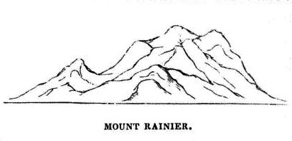
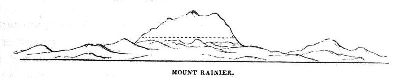
Mount Rainier, three peaks, Mount Hood:
[Vol.4, Chapt.IX, p.330]
... The scenery around Nisqually is very much enhanced in beauty by the splendid appearance of Mount Rainier, which lies nearly east of it; and from some of the open prairies there are three of these magnificent snowy peaks in sight. They are all nearly regular cones, with cleft tops, as though they had a terminal crater on their summit. I was exceedingly anxious to make the ascent of one of these, Mount Hood; but owing to the non-arrival and loss of the Peacock, I found it impossible to do so. ...
Mount St. Helens:
[Vol.4, Chapt.IX, p.341]
... The Columbia, where the Cowlitz joins it, is a broad flowing stream, and was at this time much swollen. We had, after entering it, about forty miles yet to make, and it was past noon; but we glided briskly on with the current ... Near the mouth of the Cowlitz is a high conical hill, which has received the name of Mount Coffin, from its having been a burial-place of the Indians ... About ten miles lower down, we passed Oak Point, where the river turns nearly at right angles, taking its course along a barrier of trap rocks which it here meets on its west side, and which rises eight hundred feet perpendicularly above its surface. On the other side of the river is one of the remarkable prairies of the country, covered with tall waving grass, and studded with many oaks, from which the point takes its name. What adds additional interest and beauty to the scene is Mount St. Helen's, which may be seen from the sea when eighty miles distant: its height I made nine thousand five hundred and fifty feet. ...
Mount Hood, May 29, 1841:
[Vol.4, Chapt.IX, p.358-359]
... In one of our rides [from Fort Vancouver] we visited the site of the first fort at Vancouver: it is less than a mile from the present position, and is just on the brow of the upper prairie. The view from this place is truly beautiful: the noble river can be traced in all its windings, for a long distance through the cultivated prairie, with its groves and clumps of trees; beyond, the eye sweeps over an interminable forest, melting into a blue haze, from which Mount Hood, capped with its eternal snows, rises in great beauty. The tints of purple which appear in the atmosphere, are, so far as I am aware, peculiar to this country. This site was abandoned, in consequence of the difficulty of obtaining water, and its distance from the river, which compelled them to transport every article up a high and rugged road. ... I also visited the grist-mill, which is situated on a small stream ... From the mill we crossed over to one of the sheep-walks on the high prairie. ... We reached the fort just at sunset, after a ride of twenty miles. It was such a sunset as reminded me of home: the air was mild, and a pleasant breeze prevailed fromt he west; Mount Hood showed itself in all its glory, rising out of the purple haze with which the landscape was shrouded.
Mount Rainier, May 29, 1841, party led by Lieutenant Johnson, heading east to the Okanogan:
[Vol.4, Chapt.XII, p.451]
... Mount Rainier, from the top, bore south-southwest, apparently not more than ten miles distant. A profile of the mountain indicates that it has a terminal crater, as well as some on its flanks. The barometer stood at 24.950 in.: five thousand and ninety-two feet. There was another, to the north-northeast, covered with snow, and one to the west appeared about two hundred feet higher than the place where the observations were taken.
Mount Rainier, June 1, 1841, party led by Lieutenant Johnson, heading east to the Okanogan:
[Vol.4, Chapt.XII, p.455]
... From the summit of one of the hills, a sketch of Mount Rainier, and of the intervening range, was obtained.
Mount Rainier and Mount St. Helens, June 1841:
[Vol.4, Chapt.XII, p.466-468]
... Lieutenant Johnson and Mr. Maxwell now determined to pay a visit to the missionaries who were stationed at Chimikaine, distant only half a day's ride. The rest of the party proceeded along the banks of the Columbia to Fort Colville, a post of the Hudson Bay Company, next in importance to Vancouver. ... Lieutenant Johnson, in company with Mr. Maxwell, proceeded up the Spokane ... After leaving the Spokane, they rode in a northeast direction, over hills covered with pines, and through valleys rich with fine meadows; an, after a ride of thirty-five miles from the mouth of the Spokane, reached the missionary station of Chimikaine. ...
... Cornelius, or Bighead, whose native name is Silimxnotylmilakabok, is chief of the Spokane tribe -- not by birth, but having gained the station by his shrewdness. With the title, however, he has acquired but little real authority, although he is the most influential of the Flathead nation; for his commands are often opposed with impunity by the lowest vagabond, and he himself is sometimes personally insulted without fear or danger of punishment. The dignity of rank, therefore, it will be seen, is not looked upon with much respect among these tribes. Cornelius is about sixty years of age, tall and slender, with a dignified carriage; has a thin wrinkled face, and a far-retreating forehead. He has an expression of intelligence and self-possession, which impresses a visitor very favourably. He is represented as being very pious; and, as far as outward appearances and loud praying go, is certainly entitled to be so considered.
He gives an account of a singular prophecy that was made by one of their medicine-men, some fifty years ago, before they knew any thing of white people, or had heard of them. Cornelius, when about ten years of age, was sleeping in a lodge with a great many people, and was suddenly awakened by his mother, who called out to him that the world was falling to pieces. He then heard a great noise of thunder overhead, and all the people crying out in great terror. Something was falling very thick, which they at first took for snow, but on going out they found it to be dirt: it proved to be ashes, which fell to a depth of six inches, and increased their fears, by causing them to suppose that the end of the world was actually at hand. The medicine-man arose, told them to stop their fear and crying, for the world was not about to fall to pieces. "Soon," said he, "there will come from the rising sun a different kind of men from any you have yet seen, who will bring with them a book, and will teach you every thing, and after that the world will fall to pieces." Although there is not much reliance to be placed in the truth of this story, yet it shows the desire the Indians have to perpetuate the truth; and now that its actual fulfillment, as they say, has come to pass, it has acquired greater force, and is employed by them as an argument why the tribes should embrace the Christian religion. There is little doubt that the fall of ashes took place, for many traces of such phenomena are to be seen in all parts of the middle section of Oregon;* but they had knowledge of the whites long before the epoch designated. A proof that the white race was then known to them, may be cited in the person of a half-breed Canadian, who is now living at Colville, who had served under Burgoyne, and been fifty years in this country. Besides, the appearance of the Spaniards, and English under Cook, on the coast, the existence of white men must have become known through the intercommunication of the different nations. ...
Lieutenant Johnson left the mission the next afternoon for Colville, under the guidance of the son of Cornelius ...
|
* Within the last year, the craters on top of Mount Rainier and Mount St. Helen's have been in activity.
... NOTE: Vol.4, Chapt.XII, covers the year 1841, with the narrative published in 1844. Depending on when this last line was added, gives a date range of ca.1841-1844 for Rainier and St. Helens.
|
Mount Rainier, July 1841:
[Vol.4, Chapt.XII, p.440]
... The height of Mount Rainier was obtained by measuring a base line on the prairies, in which operation I was assisted by Lieutenant Case, and the triangulation gave for its height, twelve thousand three hundred and thirty feet.
While engaged in these duties, I noticed from a point of the prairie, the white cones of both Mount St. Helen's and Mount Hood very distinctly. These mountains all resemble each other closely, and appear in some points of view as perfect cones. They give great interest and grandeur to the scenery. Mount Rainier is at all times a very striking object from the prairies about Nisqually, rising as it does almost imperceptibly from the plain, with a gradual slope, until the snow-line is reached, when the ascent becomes more precipitous.
The ascent of these mountains has never been effected, but it was my intention to attempt it, if my other duties had permitted, as I was very anxious to get a view of their terminal craters. The absence of the Peacock, however, and the great amount of work necessarily devolving on the rest of the squadron, made it impossible for me to undertake this additional labour.
Cascade Range:
[Vol.5, Chapt.IV, p.147-148]
... There have been no observations kept by the missionaries in this lower section of the country. It is liable, from the experience of our parties, to early frosts, owing to the proximity of the Snowy Mountains. ... The southwest winds are caused by the vast extent of the sandy and arid country, lying east of the Cascade and Californian range of mountains, which, becoming heated, rarefies the air, and causes an indraught from the west. ...
Mount Shasta, September 29, 1841:
[Vol.5, Chapt.VII, p.251-252]
... On the 29th, they set out to ascend the Boundary Mountains, which separate Mexico from the United States. It is a range of hills from twelve hundred to two thousand feet high, some of whose summits have a mural front; the features of all the ridges wear a basaltic appearance, though some of them are of sandstone, and contain fossils. ... At the summit of this range, they got their first view of the Klamet Valley. It was beneath them, walled on both sides by high basaltic hills, one beyond another. Mount Shaste, a high, snowy peak, of a sugar-loaf form, which rose through the distant haze, bore southward, forty-five miles distant. They descended on the south side, and encamped on the banks of Otter creek, within a mile of the Klamet river. ...
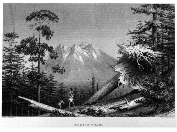
"Shasty Peak", drawn by A.T. Agate, engraved by G.B. Ellis.
-- Click to enlarge
|
-- Information courtesy College of the Siskiyous Mount Shasta Collection website, 2011:
The earliest known picture of Mount Shasta was sketched by Alfred Thomas Agate. This picture, entitled 'Shasty Peak', was drawn in 1841 and first published in 1844 as a full page steel engraving in Volume V of the five volume report by the commander of the expedition, Charles Wilkes.
The report, titled the "Narrative of the United States Exploring Expedition, 1838, 1839, 1840, 1841, 1842" was published by Congress and limited to one hundred copies, many of which were sent to foreign heads of state, and most of which have been lost. Wilkes was granted a special copyright on the volumes, and he privately published 150 more sets. Later he issued an additional 1,000 sets. Many trade editions were published in the decade to follow, the last being printed in 1856. But only the earliest three editions contain the engraving of Mount Shasta.
|
Mount Shasta, October 3, 1841:
[Vol.5, Chapt.VII, p.255-256]
... On the 3d, they continued their route up the plain, and soon reached its termination, after which they entered the forest on the slopes of the Shaste Range; their bath was rendered very broken and uneven by the knolls of trachyte which were seen in every direction. On arriving at the top of the ridge, they had a magnificent view of the snowy peak of Shaste, with a nearer and intermediate one destitute of snow, with tall pines growing nearly to its top. Where the surface could be seen, it appeared as though it was covered with large blocks of rock: its conical shape proved its volcanic character, although no crater could be perceived.
The Shaste Peak is a magnificent sight, rising as it does to a lofty height, its steep sides emerging from the mists which envelope its base, and seem to throw it off to an immense distance; its cleft summit gave proof of its former active state as a volcano. The snow lies in patches on the sides and part of the peak of this mountain; but there is a great difference in the position of its snow-line from that of Mount Hood or St. Helens's. Its height is said to be fourteen thousand three hundred and ninety feet, but Lieutenant Emmons thinks it is not so high. After passing this ridge, they soon met the head waters of the Sacramento, flowing to the southward, and their camp was pitched on the banks of another stream, that came from the Shaste Peak.
|
