The Volcanoes of
Lewis and Clark
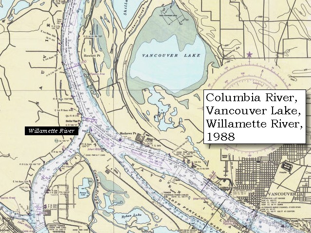
November 4, 1805
Vancouver, Washington - Columbia River Slough to Ridgefield
 
Home
The Volcanoes of Lewis and Clark

Map of the Journey
Volcanoes, Basalt Plateaus, Major Rivers, etc.

The Volcanoes
Mount Adams, Mount Hood, Mount Jefferson, Mount Rainier, and Mount St. Helens

CALENDAR of the Journey
October 1805 to June 1806

Along the Journey
Pacific Northwest Maps - Columbia River, Volcanoes, Flood Basalts, Missoula Floods, Geology, etc.

The Corps of Discovery
The Journey of Lewis and Clark

About the Reference Materials
The Journals, Biddle/Allen, DeVoto, Gass, Moulton, Topo Maps, and others

USGS Lewis and Clark Links
Links to USGS Websites highlighting the Lewis and Clark Journey

Resources
Publications Referenced and Websites Visited


PREVIOUS

November 3
Columbia River Heading West, Rooster Rock to Columbia River Slough
November 4

Vancouver, Washington,
Columbia River Slough to Ridgefield NWR

Government Island and Government Island State Rec Area, Interstate 205 Bridge, Portland International Airport, Fort Plain, Tomahawk Island, Fort Vancouver, Fort Vancouver National Historic Site, Pearson Field, Hayden Island, Vancouver (Washington), Interstate 5 Bridge, Willamette River, Portland, Oregon, Sauvie Island, FIVE VOLCANOES, Vancouver Lake and Vancouver Lake Park, and Ridgefield NWR
CONTINUE

November 5
Heading to the Pacific, Ridgefield NWR to Prescott Beach, Oregon
 

On October 7, 1805, Lewis and Clark and the "Corps of Discovery" began their journey down the Clearwater River and into the volcanics of the Pacific Northwest. The Corps travelled from the Clearwater to the Snake and down the "Great Columbia", finally reaching the Pacific Ocean on November 15, 1805. Along the journey they encountered the lava flows of the Columbia Plateau, river channels carved by the great "Missoula Floods", and the awesome beauty of five Cascade Range volcanoes.

Map, Lewis and Clark in the Pacific Northwest, click for brief
                         summary
[Click map for brief summary about the area]


To the Pacific - November 1805
Vancouver, Washington - Columbia River Slough to Ridgefield
 

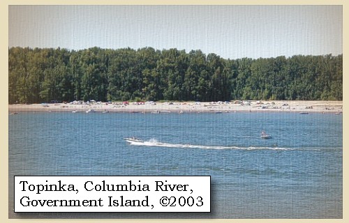
Lewis and Clark's camp of November 3, 1805, was located on the north shore of "Diamond Island", today the island complex known as Government Island.

Monday, November 4, 1805
The weather was cloudy and cool, and the wind from the west. During the night, the tide rose eighteen inches near our camp. We set out about eight o'clock, and at the distance of three miles came to the lower end of Diamond island [Government Island]. It is six miles long, nearly three in width, and like the other islands, thinly covered with timber, and has a number of ponds or small lakes scattered over its surface. Besides the animals already mentioned we shot a deer on it this morning. Near the end of Diamond island [Government Island] are two others, separated by a narrow channel filled at high tides only, which continue on the right for the distance of three miles, and like the adjacent low grounds, are thickly covered with pine.

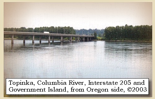
Since 1982 th Interstate 205 Bridge has crossed Government Island linking Portland, Oregon, with Vancouver, Washington.


Along the Journey - November 4, 1805
Government Island, 2003

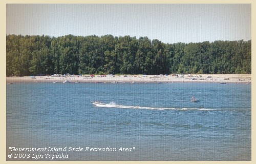
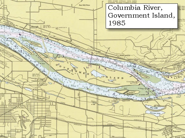
Government Island and Government Island State Recreation Area:
In 1805 Lewis and Clark reached a cluster of Islands - the easternmost one they called "Diamond Island" because of it's shape. Their camp of November 3, 1805 was on this island. Today, the largest island in this cluster is known as Government Island, a name acquired when the military grazed cattle on the island. Government, Lemon, and McGuire Islands are located in the Columbia River northeast of Portland International Airport between Columbia River River Mile 111.5 and River Mile 119. The island complex, consists of approximately 2,200 acres. Access to Government Island is by boat only. There are two docks and a floating tie-up on the north side of the island. With 15 miles of shoreline and a free primitive campground, the park is popular with anglers. The interior of the island is still used as a cattle ranch and also contains protected natural areas. Entry to the interior is prohibited. -- Port of Portland Website, 2002, and Oregon State Parks and Recreation Website, 2003


Map, 1887, Camas and Washougal vicinity, click to enlarge Map, 1985, Government Island, click to enlarge NASA Image, 1992, Columbia River with Portland, Oregon, and Vancouver, Washington, click to enlarge NASA Image, 1992, Columbia River and Government Island, click to enlarge Image, 2003, Government Island
  1. 1887 Map (section of original), Columbia River and the Camas and Washougal vicinity, including Government Island. (Click to enlarge). Government Island, while not named on this map, is the large island located to the left of Lady Island, the island located at the mouth of the Washougal River. Original Map: The Columbia River from Celilo to the mouth showing locations of the salmon fisheries, 1887. Scale ca. 1:375,000, Relief shown by hachures. U.S. Army Corps of Engineers, Engineer Office, G.P.O. 1888. University of Washington Archives #UW128. -- University of Washington Library Archives Website, 2002
  2. 1985 Map, Government Island (section of original). (Click to enlarge). Office of Coast Surveys, Historical Maps and Charts, Columbia River, Vancouver to Bonneville, 1985, Chart#18531, 1:40,000. -- NOAA Office of Coast Survey Website, 2004
  3. 1992, NASA Image, Columbia River, Portland, Oregon, and Vancouver, Washington (section of original). (Click to enlarge). View from space - west-looking, low-oblique photograph, showing a section of the Columbia River with Government Island, the Sandy River, Portland, Oregon, and Vancouver, Washington, September 1992. The Columbia River is flowing from bottom (east) to top (west). NASA Earth from Space #STS047-096-066. -- NASA Earth from Space Website, 2002
  4. 1992, NASA Image, Columbia River and Government Island (section of original). (Click to enlarge). View from space - West-looking, low-oblique photograph, showing a section of the Columbia River with Government Island, September 1992. Interstate 205 (white line, center) can be seen crossing Government Island from Portland, Oregon (left) to Vancouver, Washington (right). NASA Earth from Space #STS047-096-066. -- NASA Earth from Space Website, 2002
  5. 2003, Government Island and Government Island State Recreation Area. (Click to enlarge). Copyright © 2003 Lyn Topinka, private archives, used with permission.


Interstate 205 Bridge, 2003

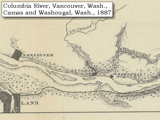
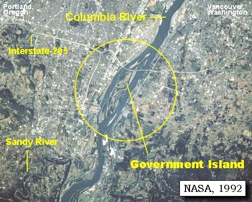
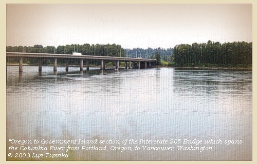
Interstate-205 Bridge:
In 1982, the Interstate-205 Bridge (Glenn Jackson Bridge) was completed, spanning the Columbia River from Portland, Oregon, to Vancouver, Washington. Part of the bridge crosses Government Island.

Map, 1985, Government Island, click to enlarge Image, 2003, Interstate 205 Bridge
  1. 1985 Map, Government Island (section of original). (Click to enlarge). Office of Coast Surveys, Historical Maps and Charts, Columbia River, Vancouver to Bonneville, 1985, Chart#18531, 1:40,000. -- NOAA Office of Coast Survey Website, 2004
  2. 2003, Government Island and the Interstate 205 Bridge. (Click to enlarge). The Interstate 205 bridge connects Portland, Oregon, with Vancouver, Washington, and crosses Government Island. Copyright © 2003 Lyn Topinka, private archives, used with permission.


Just below the last, we landed on the left bank of the river, at a village of twenty-five houses [today's Portland International Airport]. ......


Along the Journey - November 4, 1805
Columbia River and Portland International Airport, 2003

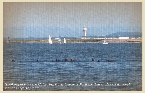
Portland International Airport:
Today's Portland International Airport (PDX) was the former site of a Neerchokioo village, used by the Shahala Indians as a temporary residence for gathering wapato, a potato-like water root. Visited twice by Lewis and Clark, the site is now under the airport parking structure. PDX is located 10 miles east of downtown Portland, Oregon. -- Lewis and Clark Bicentennial in Oregon Website, 2002


Map, 1985, Hayden Island to Portland International Airport, click to enlarge Image, 2003, Portland International Airport, Portland, Oregon
  1. 1985 Map, Hayden Island to Portland International Airport (section of original). (Click to enlarge). Includes Vancouver, Washington, Interstate 5 Bridge, Hayden and Tomahawk Islands, Ryan Point, and Portland International Airport (PDX). Office of Coast Surveys, Historical Maps and Charts, Columbia River, Vancouver to Bonneville, 1985, Chart#18531, 1:40,000. -- NOAA Office of Coast Survey Website, 2004
  2. 2003, Looking across the Columbia River towards Portland International Airport, Portland, Oregon. (Click to enlarge). Image shot from Ryan Point, Washington. Copyright © 2003 Lyn Topinka, private archives, used with permission.


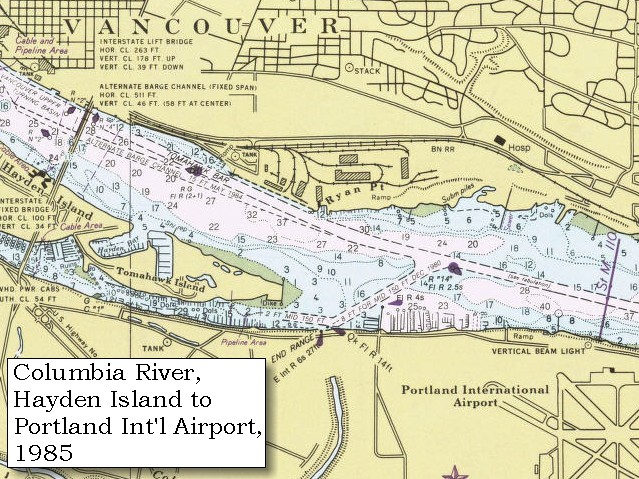
We resumed our journey, and at seven miles distance came to the head of a large island near the left [Hayden Island, see information below]. On the right shore is a fine open prairie [Fort Plain, today's Vancouver, Washington, area between Ryan Point and Fort Vancouver/Pearson Airpark] for about a mile, back of which the country rises, and is supplied with timber, such as white oak, pine of different kinds, wild crab, and several species of undergrowth, while along the borders of the river, there are only a few cottonwood and ash trees. In this prairie were also signs of deer and elk.
"... I walked out on the Stard. Side found the country fine, an open Prarie for 1 mile back of which the wood land comence riseing back ... a Pond on the Stard Side, off from the river. ..." [Clark, November 4, 1805, first draft]
"... at 7 miles below this village passed the upper point of a large Island nearest the Lard. Side, a Small Prarie in which there is a pond opposit on the Stard. Here I landed and walked on Shore, about 3 miles a fine open Prarie for about 1 mile, back of which the countrey rises gradually and wood land comencies ..." [Clark, November 4, 1805]

Many ponds - now filled in - were in this area around Ryan Point, Fort Vancouver, and Pearson Airpark. Mount Hood, Oregon, is visible throughout this entire section of the Columbia River. Today this section is heavily built-up with industry and condominiums.


Along the Journey - November 4, 1805
Mount Hood and Pearson Field, 2004

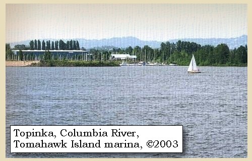
Fort Plain:
The area between Fort Vancouver National Historic Site, Pearson Airpark, and Ryan Point, was once called "Fort Plain", a former area of prairie and wetlands that formed a highly productive location for native food resources. In the mid-19th century, this place was called "Fort Plain" through its association with the Hudson's Bay Company's Fort Vancouver. Prehistoric artifacts found at Fort Vancouver National Historic Site confirm that American Indians occupied Fort Plain long before Lewis & Clark arrived. Fort Plain has been identified as a Lewis and Clark stopping place associated with their travels down the Columbia River on November 4, 1805, and a campsite during their travels up the Columbia on March 30, 1806. The journals identify a small prairie and pond at the upstream point of a large island, corresponding to modern Tomahawk Island. -- U.S. National Park Service, Fort Vancouver Historic Reserve Website, 2003


Map, 1985, Hayden Island to Portland International Airport, click to enlarge Image, 2004, Mount Hood, Oregon, and Pearson Field, Vancouver, Washington
  1. 1985 Map, Hayden Island to Portland International Airport (section of original). (Click to enlarge). Includes Vancouver, Washington, Interstate 5 Bridge, Hayden and Tomahawk Islands, Ryan Point, and Portland International Airport (PDX). Office of Coast Surveys, Historical Maps and Charts, Columbia River, Vancouver to Bonneville, 1985, Chart#18531, 1:40,000. -- NOAA Office of Coast Survey Website, 2004
  2. 2004, Mount Hood, Oregon, and Pearson Field, Vancouver, Washington. (Click to enlarge). Copyright © 2004 Lyn Topinka, private archives, used with permission.


When we landed for dinner, a number of Indians from the last village, came down for the purpose, as we supposed, of paying us a friendly visit, as they had put on their favourite dresses. ...... We smoked with them and endeavoured to show them every attention, but we soon found them very assuming and disagreeable companions. ......
"... dureing the time we were at dinner those fellows Stold my pipe Tomahawk which they were Smoking with, I imediately Serched every man and the canoes, but Could find nothing of my Tomahawk ..." [Clark, November 4, 1805]

Lewis and Clark referred to this island as "Tomahawk Island", a name which in 1927 was re-assigned to a new island on the upstream tip of Hayden Island.


Along the Journey - November 4, 1805
Marina on Tomahawk Island, 2003

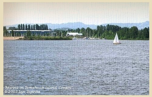
Tomahawk Island:
Lewis and Clark gave the name "Tomahawk Island" to a small island between "Image Canoe Island" (Hayden Island) and the Washington shore of the Columbia River after an incident during which Clark's tomahawk pipe was stolen. The island was eventually washed away. In 1927 the United States Board of Geographic Names (USBGN) was petitioned to assign the name to a new island that formed on the upstream end of Hayden Island. The new Tomahawk Island, along with Hayden Island have now been consolidated by river silting and road construction. -- Washington State Historical Society Website, 2004, "Lasting Legacy"


Map, 1985, Hayden Island to Portland International Airport, click to enlarge Image, 2003, Tomahawk Island marina
  1. 1985 Map, Hayden Island to Portland International Airport (section of original). (Click to enlarge). Includes Vancouver, Washington, Interstate 5 Bridge, Hayden and Tomahawk Islands, Ryan Point, and Portland International Airport (PDX). Office of Coast Surveys, Historical Maps and Charts, Columbia River, Vancouver to Bonneville, 1985, Chart#18531, 1:40,000. -- NOAA Office of Coast Survey Website, 2004
  2. 2003, Marina on Tomahawk Island, Oregon, as seen from the Washington shore. (Click to enlarge). Copyright © 2003 Lyn Topinka, private archives, used with permission.


We then proceeded [Fort Vancouver and Pearson Field area]


Along the Journey - November 4, 1805
Fort Vancouver, 2004

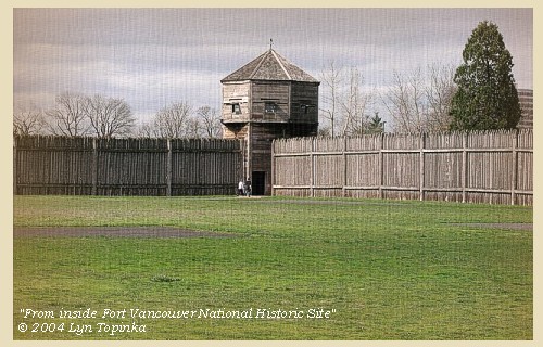
Fort Vancouver:
In May, 1792, American trader/sailor Robert Gray became the first non-native to enter the fabled "Great River of the West," the Columbia River. Later that year, British Lt. William Broughton, serving under Capt. George Vancouver, explored 100 miles upriver. Along the way, he named a point of land along the shore in honor of his commander. In 1806, American explorers Meriwether Lewis and William Clark camped near the Vancouver waterfront on the return leg of their famed western expedition. Lewis characterized the area as "the only desired situation for settlement west of the Rocky Mountains." In 1825, Dr. John McLoughlin decided to move the northwest headquarters of the Hudson's Bay Company from Astoria to a more favorable setting upriver. He named the site after Point Vancouver on Broughton's original map. Fort Vancouver was thus born. The new site was on the north bank of the Columbia, slightly upstream from the mouth of the Willamette River on the opposite side. The fort itself, after an initial, arduous four years on a nearby bluff, would be built on a plain with easy access to the water, but just beyond the flood plain. The surrounding environment was broad areas of prairie and trees, sloping upward to dense fir forests; it was known as Jolie Prairie or Belle Vue Point because of its intense natural beauty. McLoughlin's superiors were well pleased with the choice, not only for its situation, but most importantly for its rich pasture and amenable climate. -- City of Vancouver Website, 2002, and U.S. National Park Service Website, Fort Vancouver National Historic Site, 2002


Map, 1849, Alexander Ross's Columbia River, click to enlarge Map, 1853, Washington and Oregon and the Columbia River, click to enlarge Map, 1854, Columbia River, Fort Vancouver area, click to enlarge Map, 1855, Columbia River, Vancouver to the Pacific, click to enlarge Map, 1887, Portland and Vancouver vicinity, click to enlarge Map, 1985, Hayden Island to Portland International Airport, click to enlarge NASA Image, 1992, Columbia River with Portland, Oregon, and Vancouver, Washington, click to enlarge NASA Image, 1992, Columbia River at the Mouth of the Willamette, click to enlarge Image, 1990, Columbia River looking west, Vancouver Lake, click to enlarge Engraving, 1850, Fort Vancouver and Mount Hood, click to enlarge Image, 2004, Fort Vancouver, from the inside
  1. 1849 Map (section of original), Alexander Ross's Columbia River. (Click to enlarge). Original Map: Map of the Columbia to illustrate Ross's adventures. Author: Alexander Ross; Publication Date: 1849; Publisher: London, Smith, Elder and Co., 1849. Washington State University Archives #WSU478. -- Washington State University Early Washington Maps Digital Collection Website, 2004
  2. 1853 Map, Washington and Oregon and the Columbia River, from the Clearwater River to the Snake River and down the Columbia River to the Pacific Ocean (section of original). (Click to enlarge). Includes: Clearwater River (Kooskooski), Lapwai Creek (Lapwai R.), Snake River (Saptin or Lewis R.), Columbia River (Columbia R.), Yakima River (Yakima R.), Walla Walla River (Wallawalla R.), Umatilla River (Umatilla R.), Willow Creek (Quesnells R.), John Day River (John day's R.), Deschutes River (Fall R.), Willamette River (Willammette R.), and Cowlitz River (Cowlitz R.). Original Map: "Map of California, Oregon, Washington, Utah, and New Mexico (1853)", by Thomas Cowperthwait & Co. Washington State University Archives #WSU22. -- Washington State University Library Collections Website, 2003
  3. 1853-54 Map, Columbia River, including the Fort Vancouver area (section of original). (Click to enlarge). Includes Longview, Washington (Monticello), Coweeman River (Minter R.), Kalama River (Ca-la-ma R.), Lewis River (Cath-la-pootle R.), Willamette River, Fort Vancouver, Cape Horn, and "The Cascades". Vancouver Lake is depicted but not labeled. Original Map: "Rocky Mountains to Puget Sound : from explorations and surveys / made under the direction of the Hon. Jefferson Davis, Secretary of War by Isaac I. Stevens Governor of Washington Territory, 1853-4." Inset: (Supplementary sketch) Reconnaissance of the railroad route from Wallawalla to Seattle via Yak-e-mah River & Snoqualmie Pass. By A. W. Tinkham in January 1854. Drawn by J. R. P. Mechlin. 20 x 28 cm. Topographer, John Lambert, Published in Washington D.C., 1859, 1:1,200,000, Notes: From the U.S. War Department, Explorations and Surveys for a Railroad Route from the Mississippi River to the Pacific Ocean, Topographical Maps, to Illustrate the Various Reports, U.S. Library of Congress American Memories Reference "LC Railroad Maps #156". -- U.S. Library of Congress, American Memories Website, 2004
  4. 1855 Map, Columbia River from Vancouver to the Pacific (section of original). (Click to enlarge). Original Map: "Map of Oregon and Washington Territories: showing the proposed Northern Railroad route to the Pacific Ocean, by John Disturnell, 1855. University of Washington Archives #UW155. -- University of Washington Library Collections Website, 2002
  5. 1887 Map (section of original), Columbia River and the Portland and Vancouver vicinity. (Click to enlarge). Original Map: The Columbia River from Celilo to the mouth showing locations of the salmon fisheries, 1887. Scale ca. 1:375,000, Relief shown by hachures. U.S. Army Corps of Engineers, Engineer Office, G.P.O. 1888. University of Washington Archives #UW128. -- University of Washington Library Archives Website, 2002
  6. 1985 Map, Hayden Island to Portland International Airport (section of original). (Click to enlarge). Includes Vancouver, Washington, Interstate 5 Bridge, Hayden and Tomahawk Islands, Ryan Point, and Portland International Airport (PDX). Office of Coast Surveys, Historical Maps and Charts, Columbia River, Vancouver to Bonneville, 1985, Chart#18531, 1:40,000. -- NOAA Office of Coast Survey Website, 2004
  7. 1992, NASA Image, Columbia River, Portland, Oregon, and Vancouver, Washington (section of original). (Click to enlarge). View from space - west-looking, low-oblique photograph, showing a section of the Columbia River with Government Island, Sandy River, Portland, Oregon, and Vancouver, Washington, September 1992. The Columbia River is flowing from bottom (east) to top (west). NASA Earth from Space #STS047-096-066. -- NASA Earth from Space Website, 2002
  8. 1992, NASA Image, Columbia River at the mouth of the Willamette (section of original). (Click to enlarge). View from space - West-looking, low-oblique photograph, showing a section of the Columbia River with Government Island, September 1992. Portland, Oregon is to the left and Vancouver, Washington is to the right. NASA Earth from Space #STS047-096-066. -- NASA Earth from Space Website, 2002
  9. 1990, Aerial view, Columbia River looking west, with Vancouver Lake on the right. (Click to enlarge). Columbia River at Portland and Vancouver, looking west. Oregon is to the left and Washington State is to the right. Vancouver Lake is on the right. Photographer: Bob Heims. Photograph Date: June 21, 1990. U.S. Army Corps of Engineers Photo Archives #Col0502.jpg -- U.S. Army Corps of Engineers Photo Archives Website, 2003
  10. 1850 Engraving, Fort Vancouver, with Mount Hood in the background. (Click to enlarge). Engraving by: Gustave Sohon, November 1850. Image from U.S. War Dept.'s Reports of explorations and surveys to ascertain the most practicable and economical route for a railroad from the Mississippi River to the Pacific Ocean, 1860, v. 12, pt.1, pl.44. University of Washington Libraries Collection #NA4171. -- University of Washington Archives Website, 2002
  11. 2004, Fort Vancouver National Historic Site, from inside the fort. (Click to enlarge). Copyright © 2004 Lyn Topinka, private archives, used with permission.


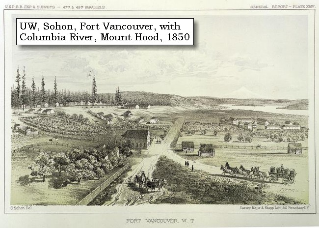
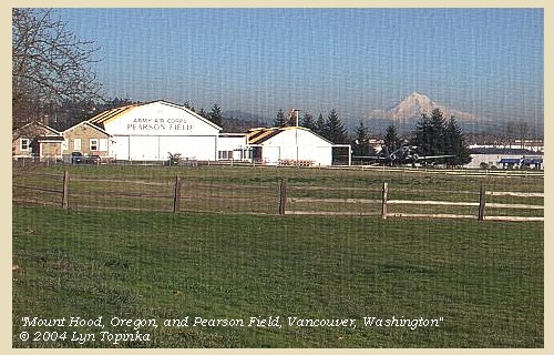
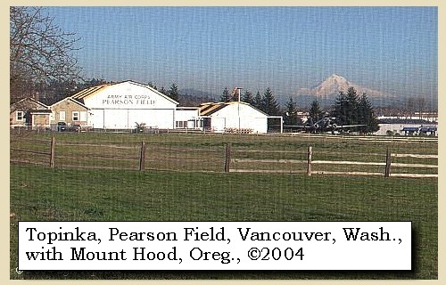
Fort Vancouver National Historic Site:
Fort Vancouver became a National Monument in 1948 and a National Historic Site in 1961. In 1996, the 366-acre Vancouver National Historic Reserve was established to protect adjacent, historically significant historical areas. It includes Fort Vancouver National Historic Site, as well as Vancouver Barracks, Officers' Row, Pearson Field, The Water Resources Education Center, and portions of the Columbia River waterfront. The General O.O. Howard House serves as the visitor center for the Reserve, and is staffed by National Park Service personnel. -- U.S. National Park Service Website, Fort Vancouver National Historic Site, 2002

Pearson Field:
In 1905, one hundred years after the Lewis and Clark expedition, Lincoln Beachey in the dirigible, The Gelatin, took off from Jantzen Beach, Oregon (during Portland's 1905 Lewis and Clark Exposition) and landed on the polo grounds of Vancouver Barracks, Vancouver, Washington. This was the first aerial crossing of the Columbia River, and marked the beginning of Pearson Field, which today remains the oldest continually operating airfield in the United States. -- Pearson Airpark Museum Website, 2004


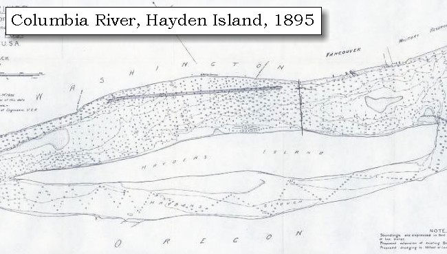
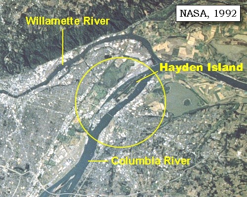
and soon met two canoes with twelve men of the same Skilloot nation, who were on their way from below. The larger of the canoes was ornamented with the figure of a bear in the bow, and a man in the stern, both nearly as large as life, both made of painted wood, and very neatly fixed to the boat. In the same canoe were two Indians finely dressed and with round hats. This circumstance induced us to give the name of Image canoe to the large island [Hayden Island], the lower end of which we now passed at the distance of nine miles from its head.


Along the Journey - November 4, 1805
NASA view, Hayden Island, 1992

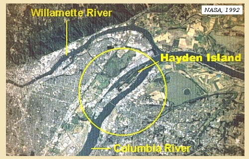
Hayden Island:
Lewis and Clark called this island "Image Canoe Island", because of the ornamented native canoes that they observed on its shore. Today the island is named after Guy Hayden, an early Oregon pioneer, who once owned the island. -- Washington State Historical Society Website, 2004, "Lasting Legacy"


Map, 1887, Portland and Vancouver vicinity, click to enlarge Map, 1895, Hayden Island, click to enlarge Map, 1985, Hayden Island to Portland International Airport, click to enlarge NASA Image, 1992, Columbia River with Portland, Oregon, and Vancouver, Washington, click to enlarge NASA Image, 1992, Columbia River, Willametter River, and Hayden Island, click to enlarge
  1. 1887 Map (section of original), Columbia River and the Portland and Vancouver vicinity, including Hayden Island. (Click to enlarge). Hayden Island, while not named, is the long island between Vancouver, Washington and Portland, Oregon. The diamond-shaped island upstream (to the right) is Government Island. Original Map: The Columbia River from Celilo to the mouth showing locations of the salmon fisheries, 1887. Scale ca. 1:375,000, Relief shown by hachures. U.S. Army Corps of Engineers, Engineer Office, G.P.O. 1888. University of Washington Archives #UW128. -- University of Washington Library Archives Website, 2002
  2. 1895 Map, Hayden Island (section of original). (Click to enlarge). Original map: "Columbia River, Vancouver Wash. to Mouth of Willamette River, 1895". Survey Septembaer 1893 mad under the direction of Major James C. Post, Corps of Engineers, U.S.A. Washington State University Archives #WSU575. -- Washington State University Archives Website, 2004
  3. 1985 Map, Hayden Island to Portland International Airport (section of original). (Click to enlarge). Includes Vancouver, Washington, Interstate 5 Bridge, Hayden and Tomahawk Islands, Ryan Point, and Portland International Airport (PDX). Office of Coast Surveys, Historical Maps and Charts, Columbia River, Vancouver to Bonneville, 1985, Chart#18531, 1:40,000. -- NOAA Office of Coast Survey Website, 2004
  4. 1992, NASA Image, Columbia River, Portland, Oregon, and Vancouver, Washington (section of original). (Click to enlarge). View from space - west-looking, low-oblique photograph, showing a section of the Columbia River with Government Island, Hayden Island, Lady Island, Sandy River, Washougal River, and Portland, Oregon and Vancouver, Washington, September 1992. The Columbia River is flowing from bottom (east) to top (west). NASA Earth from Space #STS047-096-066. -- NASA Earth from Space Website, 2002
  5. 1992, NASA Image, Columbia River, Willamette River, and Hayden Island (section of original). (Click to enlarge). View from space - west-looking, low-oblique photograph, showing a section of the Columbia River, Willamette River, and Hayden Island, September 1992. Near the top of the photo the Willamette River meets the Columbia River. Just upstream (below on photo) is Hayden Island, just barely discernible as an island in this view from space. The lower half (eastern) of Hayden Island is commercially developed while the upper half (western) of Hayden Island is open space. The Interstate-5 bridge is visible crossing the Columbia River from Portland Oregon (left) to Vancouver, Washington (right). NASA Earth from Space #STS047-096-066. -- NASA Earth from Space Website, 2002


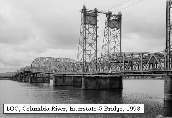
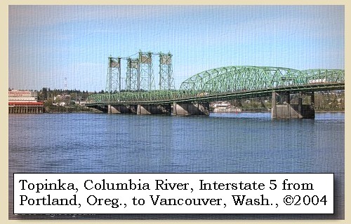
The City of Vancouver, Washington, was incorporated in this area in 1857. Between 1915 and 1917, the Interstate-5 bridge was constructed, connecting Hayden Island, Oregon, with Vancouver, Washington. Mount St. Helens can be seen from Hayden Island.


Along the Journey - March 30, 1806
Vancouver, Washington, with Mount St. Helens, 2004

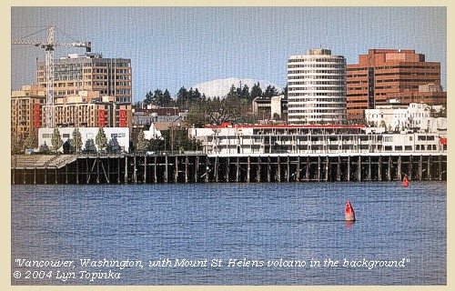
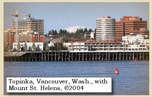
Vancouver, Washington:
In 1845, Amos and Esther Short and their eight children landed at Fort Vancouver, and eventually located a donation land claim in the wilderness near the fort and built a cabin. In 1855 Mrs. Esther Short platted the city of Vancouver, donated Esther Short Park and a long strip of waterfront to the city, and in 1857, the City of Vancouver was incorporated. -- City of Vancouver Website, 2004, and U.S. National Park Service Website, 2004, Fort Vancouver National Historic Site.


Map, 1853, Washington and Oregon and the Columbia River, click to enlarge Map, 1887, Portland and Vancouver vicinity, click to enlarge Map, 1985, Hayden Island to Portland International Airport, click to enlarge Image, 2004, Vancouver, Washington, and Mount St. Helens
  1. 1853 Map, Washington and Oregon and the Columbia River, from the Clearwater River to the Snake River and down the Columbia River to the Pacific Ocean (section of original). (Click to enlarge). Includes: Clearwater River (Kooskooski), Lapwai Creek (Lapwai R.), Snake River (Saptin or Lewis R.), Columbia River (Columbia R.), Yakima River (Yakima R.), Walla Walla River (Wallawalla R.), Umatilla River (Umatilla R.), Willow Creek (Quesnells R.), John Day River (John day's R.), Deschutes River (Fall R.), Willamette River (Willammette R.), and Cowlitz River (Cowlitz R.). Original Map: "Map of California, Oregon, Washington, Utah, and New Mexico (1853)", by Thomas Cowperthwait & Co. Washington State University Archives #WSU22. -- Washington State University Library Collections Website, 2003
  2. 1887 Map (section of original), Columbia River and the Portland and Vancouver vicinity, including Hayden Island. (Click to enlarge). Hayden Island, while not named, is the long island between Vancouver, Washington and Portland, Oregon. The diamond-shaped island upstream (to the right) is Government Island. Original Map: The Columbia River from Celilo to the mouth showing locations of the salmon fisheries, 1887. Scale ca. 1:375,000, Relief shown by hachures. U.S. Army Corps of Engineers, Engineer Office, G.P.O. 1888. University of Washington Archives #UW128. -- University of Washington Library Archives Website, 2002
  3. 1985 Map, Hayden Island to Portland International Airport (section of original). (Click to enlarge). Includes Vancouver, Washington, Interstate 5 Bridge, Hayden and Tomahawk Islands, Ryan Point, and Portland International Airport (PDX). Office of Coast Surveys, Historical Maps and Charts, Columbia River, Vancouver to Bonneville, 1985, Chart#18531, 1:40,000. -- NOAA Office of Coast Survey Website, 2004
  4. 2004, Vancouver, Washington, with Mount St. Helens in the background. (Click to enlarge). View is from Hayden Island, Oregon, looking back at Vancouver, Washington. Copyright © 2004 Lyn Topinka, private archives, used with permission.


Interstate 5 Bridge, 2004

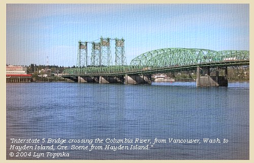
Interstate-5 Bridge:
Between 1915 and 1917, one of the largest bridges ever built up until this time was constructed over the Columbia River, between Vancouver, Washington and Hayden Island, Oregon. This bridge was more than a feat of engineering -- its construction signified an unprecedanted degree of co-operation between the citizens of Multnomah County, Oregon and Clark County, Washington who, dissatisfied with the inadequacies of the existing ferry system - the only connecting link for pedestrians and automobiles in this vicinity - eagerly rallied to the cause of an interstate bridge campaign. The bridge paved the way for a new era in automobile transportaion in the region, an era that developed so rapidly that a second, almost identical structure had to be bult alongside it some forty years later to keep pace with the enormous increase in interstate traffic. Dates of construction: 1915-1917 northbound, and 1956 southbound. -- U.S. Library of Congress Website, 2003, "American Memories"


Map, 1985, Hayden Island to Portland International Airport, click to enlarge NASA Image, 1992, Columbia River, Willamette River, and Hayden Island, click to enlarge Image, 1993, Interstate-5 bridge spanning the Columbia from Vancouver to Portland, click to enlarge Image, 2004, Interstate 5 Bridge
  1. 1985 Map, Hayden Island to Portland International Airport (section of original). (Click to enlarge). Includes Vancouver, Washington, Interstate 5 Bridge, Hayden and Tomahawk Islands, Ryan Point, and Portland International Airport (PDX). Office of Coast Surveys, Historical Maps and Charts, Columbia River, Vancouver to Bonneville, 1985, Chart#18531, 1:40,000. -- NOAA Office of Coast Survey Website, 2004
  2. 1992, NASA Image, Columbia River, Willamette River, and Hayden Island (section of original). (Click to enlarge). View from space - West-looking, low-oblique photograph, showing a section of the Columbia River, Willamette River, and Hayden Island, September 1992. Near the top of the photo the Willamette River meets the Columbia River. Just upstream (below on photo) is Hayden Island, just barely discernible as an island in this view from space. The lower half (eastern) of Hayden Island is commercially developed while the upper half (western) of Hayden Island is open space. The Interstate-5 bridge is visible crossing the Columbia River from Portland Oregon (left) to Vancouver, Washington (right). NASA Earth from Space #STS047-096-066. -- NASA Earth from Space Website, 2002
  3. 1993, Interstate 5 Bridge spanning the Columbia River from Vancouver, Washington (right) to Portland, Oregon (left). (Click to enlarge). The 1915-1917 bridge is in the foreground with the 1956 span visible behind. -- U.S. Library of Congress Website, 2003, American Memories
  4. 2004, Interstate 5 Bridge crossing the Columbia River. (Click to enlarge). View is from Hayden Island, Oregon, looking back at Vancouver, Washington. Copyright © 2004 Lyn Topinka, private archives, used with permission.


We had seen two smaller islands to the right, and three more near its lower extremity. The Indians in the canoe here made signs that there was a village behind those islands, and indeed we presumed there was a channel on that side of the river, for one of the canoes passed in that direction between the small islands, but we were anxious to press forward, and therefore did not stop to examine more minutely.

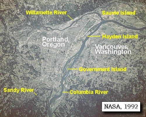
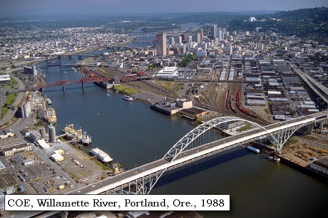
On their return trip in 1806, Lewis and Clark discovered and explored the Willamette River. Today, the city of Portland, Oregon, is built up along the banks of the Lower Willamette.


Along the Journey - November 4, 1805
Mouth of the Willamette River, 2003

Willamette River:
Most of Oregon's population, technology and agricultural centers, and important transportion, power, and communications lifelines are located in the Willamette Valley of western Oregon. The lowlands of the Willamette Valley extend approximately 75 miles along the Willamette River and contain the major cities of Portland, Salem, Corvallis, and Eugene. The valley is part of the Willamette River drainage basin, which covers 12,300 square miles between the crest of the Oregon Coast Range on the west and the Cascade Range to the east. The Willamette River is the largest river in the valley and is fed by several major tributaries, including the McKenzie, Calapooia, Santiam, Tualatin, Yamhill, and Clakamas Rivers. The valley is the major source of ground and surface water for the population centers. -- Givler and Wells, 2001


Map, 1814, Lewis and Clark on the Columbia, click to enlarge Map, 1814, Lewis and Clark on the Columbia, click to enlarge Map, 1833, Illman and Pilbrow, Columbia River, click to enlarge Map, 1837, Columbia River with Mount Hood, click to enlarge Map, 1849, Alexander Ross's Columbia River, click to enlarge Map, 1853, Washington and Oregon and the Columbia River, click to enlarge Map, 1854, Columbia River, Fort Vancouver area, click to enlarge Map, 1855, Columbia River, Vancouver to the Pacific, click to enlarge Map, 1887, Portland and Vancouver vicinity, click to enlarge Map, 1988, Mouth of the Willamette and Vancouver Lake, click to enlarge NASA Image, 1992, Columbia River with Portland, Oregon, and Vancouver, Washington, click to enlarge Image, 2003, Mouth of the Willamette River, Oregon
  1. 1814 Map, Lewis and Clark, Columbia River - west (section of original). (Click to enlarge.) The Willamette River is shown on the map (vertical river, lower left), but Lewis and Clark name ("Mult-no-mah R.") has been cropped in this view. From the "Nicholas Biddle/Paul Allen" 1814 publication. Original Map: "A Map of Lewis and Clark's Track, Across the Western Portion of North America, From the Mississippi to the Pacific Ocean". From: History of the expedition under the command of Captains Lewis and Clark : to the sources of the Missouri, thence across the Rocky Mountains and down the river Columbia to the Pacific Ocean : performed during the years 1804-5-6 : by order of the government of the United States / prepared for the press by Paul Allen. Philadelphia : Bradford and Insskeep, 1814. Harold B. Lee Library, Brigham Young University #upbover maps37. -- Brigham Young University, Harold B. Lee Library Website, 2004.
  2. 1814 Map, Lewis and Clark, Columbia River - east (section of original). (Click to enlarge.) The Willamette River is shown on the map (vertical river, lower left), with partial name ("Mult-no-mah R.") in this view. From the "Nicholas Biddle/Paul Allen" 1814 publication. Original Map: "A Map of Lewis and Clark's Track, Across the Western Portion of North America, From the Mississippi to the Pacific Ocean". From: History of the expedition under the command of Captains Lewis and Clark : to the sources of the Missouri, thence across the Rocky Mountains and down the river Columbia to the Pacific Ocean : performed during the years 1804-5-6 : by order of the government of the United States / prepared for the press by Paul Allen. Philadelphia : Bradford and Insskeep, 1814. Harold B. Lee Library, Brigham Young University #upbover maps37. -- Brigham Young University, Harold B. Lee Library Website, 2004.
  3. 1833 Map (section of original), Columbia River. (Click to enlarge). Includes Mount Hood and Mount Jefferson. Note: Mount Baker is depicted (upper middle) but Mounts Adams, Rainier and St. Helens are missing. The Columbia River is shown as "Oregon River" at its mouth and "Columbia or Oregon R." further inland. "Wappatoo Valley" is labeled. Also shows Fort Clatsop ("F. Clatsop or F. George"), the Willamette River ("Multnomah R."), Sandy River ("Quicksand R."), John Day River ("R.La Page"), Walla Walla River ("Wallwullah R."), Snake River ("Lewis R."), and the Yakima River ("Tapete R."). Original Map: Oregon Territory, 1833. Creator: Illman & Pilbrow, published by Illman & Pilbrow, New York. Comments: Illman & Pilbrow is the engraving firm which copyrighted and published this map, the actual artist is unknown. Washington State University Digital Maps Collection #WSU323. University of Washington Digital Maps Collection #UW104. -- Washington State University Early Washington Maps Digital Collection Website, 2004
  4. 1837 Map, Columbia River with Mount Hood (section of original). (Click to enlarge). Includes the "Wallamant or Multnomah R.". Original Map: Map of the Territory West of the Rocky Mountains (1837) Author: Washington Irving, Publisher: Philadelphia, Carey, Lea, & Blanchard. Washington State University Archives #WSU555. -- Washington State University Early Washington Maps Digital Collection Website, 2004
  5. 1849 Map (section of original), Alexander Ross's Columbia River. (Click to enlarge). Original Map: Map of the Columbia to illustrate Ross's adventures. Author: Alexander Ross; Publication Date: 1849; Publisher: London, Smith, Elder and Co., 1849. Washington State University Archives #WSU478. -- Washington State University Early Washington Maps Digital Collection Website, 2004
  6. 1853 Map, Washington and Oregon and the Columbia River, from the Clearwater River to the Snake River and down the Columbia River to the Pacific Ocean (section of original). (Click to enlarge). Includes: Clearwater River (Kooskooski), Lapwai Creek (Lapwai R.), Snake River (Saptin or Lewis R.), Columbia River (Columbia R.), Yakima River (Yakima R.), Walla Walla River (Wallawalla R.), Umatilla River (Umatilla R.), Willow Creek (Quesnells R.), John Day River (John day's R.), Deschutes River (Fall R.), Willamette River (Willammette R.), and Cowlitz River (Cowlitz R.). Original Map: "Map of California, Oregon, Washington, Utah, and New Mexico (1853)", by Thomas Cowperthwait & Co. Washington State University Archives #WSU22. -- Washington State University Library Collections Website, 2003
  7. 1853-54 Map, Columbia River, including the Fort Vancouver area (section of original). (Click to enlarge). Includes Longview, Washington (Monticello), Coweeman River (Minter R.), Kalama River (Ca-la-ma R.), Lewis River (Cath-la-pootle R.), Willamette River, Fort Vancouver, Cape Horn, and "The Cascades". Vancouver Lake is depicted but not labeled. Original Map: "Rocky Mountains to Puget Sound : from explorations and surveys / made under the direction of the Hon. Jefferson Davis, Secretary of War by Isaac I. Stevens Governor of Washington Territory, 1853-4." Inset: (Supplementary sketch) Reconnaissance of the railroad route from Wallawalla to Seattle via Yak-e-mah River & Snoqualmie Pass. By A. W. Tinkham in January 1854. Drawn by J. R. P. Mechlin. 20 x 28 cm. Topographer, John Lambert, Published in Washington D.C., 1859, 1:1,200,000, Notes: From the U.S. War Department, Explorations and Surveys for a Railroad Route from the Mississippi River to the Pacific Ocean, Topographical Maps, to Illustrate the Various Reports, U.S. Library of Congress American Memories Reference "LC Railroad Maps #156". -- U.S. Library of Congress, American Memories Website, 2004
  8. 1855 Map, Columbia River from Vancouver to the Pacific (section of original). (Click to enlarge). Original Map: "Map of Oregon and Washington Territories: showing the proposed Northern Railroad route to the Pacific Ocean, by John Disturnell, 1855. University of Washington Archives #UW155. -- University of Washington Library Collections Website, 2002
  9. 1887 Map (section of original), Columbia River and the Portland and Vancouver vicinity, including the Willamette River. (Click to enlarge). Original Map: The Columbia River from Celilo to the mouth showing locations of the salmon fisheries, 1887. Scale ca. 1:375,000, Relief shown by hachures. U.S. Army Corps of Engineers, Engineer Office, G.P.O. 1888. University of Washington Archives #UW128. -- University of Washington Library Archives Website, 2002
  10. 1988 Map, Mouth of the Willamette River and Vancouver Lake (section of original). (Click to enlarge). Office of Coast Surveys, Historical Maps and Charts, Columbia River, Saint Helens to Vancouver, 1988, Chart#18524, 1:40,000. -- NOAA Office of Coast Survey Website, 2004
  11. 1992, NASA Image, Columbia River, Portland, Oregon, and Vancouver, Washington (section of original). (Click to enlarge). View from space - west-looking, low-oblique photograph, showing a section of the Columbia River with Government Island, the Sandy River, Portland, Oregon, and Vancouver, Washington, September 1992. The Columbia River is flowing from bottom (east) to top (west). NASA Earth from Space #STS047-096-066. -- NASA Earth from Space Website, 2002
  12. 2003, Mouth of the Willamette River, Oregon, as seen from Blurock Landing, Washington. (Click to enlarge). Copyright © 2003 Lyn Topinka, private archives, used with permission.


Portland, Oregon, 1988

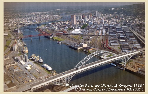
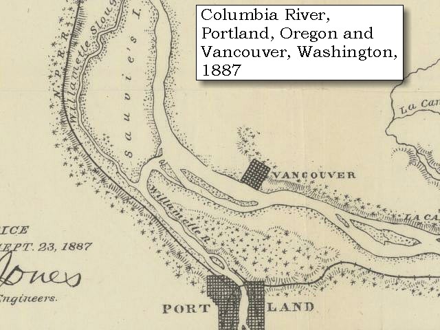
Portland, Oregon:
In 1843, Tennessee drifter William Overton and Massachusetts lawyer Asa Lovejoy beached their canoe on the banks of the Willamette River. Overcome by the beauty of the area, Overton saw great potential for this mountain-ringed, timber-rich land. His only problem was that he lacked the 25 cents needed to file a land claim. So, he struck a bargain with Lovejoy -- In return for a quarter, Overton would share his claim to the 640-acre site known as "The Clearing." Soon bored with clearing trees and building roads, Overton drifted on, selling his half of the claim to Francis W. Pettygrove. The new partners, Lovejoy and Pettygrove, couldn't decide on a name for their new township. Lovejoy was determined to name the site after his hometown of Boston, Massachusetts, while Pettygrove was equally adamant about his native Portland, Maine. They decided to flip a coin, now known as the "Portland Penny", to settle the argument. Pettygrove won on two tosses out of three. Lovejoy and Pettygrove were confident that Portland, with its deep water and abundant natural resources, would one day become a popular and prosperous port. Portland was officially incorporated on February 8, 1851, and today covers 130 square miles. -- Portland, Oregon Visitor's Association Website, 2003


Map, 1853, Washington and Oregon and the Columbia River, click to enlarge Image, 1988, Willamette River and Portland, Oregon, click to enlarge
  1. 1853 Map, Washington and Oregon and the Columbia River, from the Clearwater River to the Snake River and down the Columbia River to the Pacific Ocean (section of original). (Click to enlarge). Includes: Clearwater River (Kooskooski), Lapwai Creek (Lapwai R.), Snake River (Saptin or Lewis R.), Columbia River (Columbia R.), Yakima River (Yakima R.), Walla Walla River (Wallawalla R.), Umatilla River (Umatilla R.), Willow Creek (Quesnells R.), John Day River (John day's R.), Deschutes River (Fall R.), Willamette River (Willammette R.), and Cowlitz River (Cowlitz R.). Original Map: "Map of California, Oregon, Washington, Utah, and New Mexico (1853)", by Thomas Cowperthwait & Co. Washington State University Archives #WSU22. -- Washington State University Library Collections Website, 2003
  2. 1988 view of the Willamette River and the city of Portland, Oregon. Looking south with the Fremont Bridge in the foreground. (Click to enlarge). U.S. Army Corps of Engineers Photograph #Sce0373. Photograph Date: June 1988. Photographer: Bob Heims. U.S. Army Corps of Engineers Photo Archives. -- U.S. Army Corps of Engineers Website, 2002


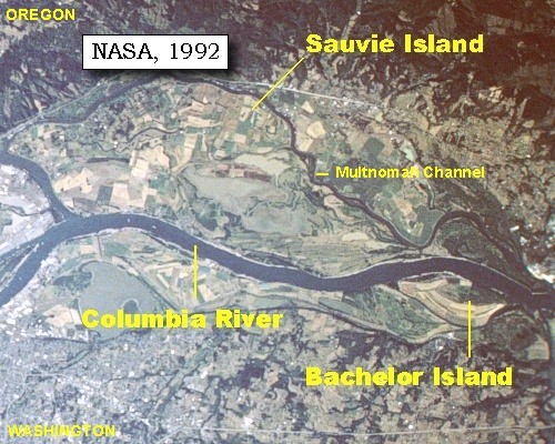
The river [Columbia River] was now about a mile and a half in width, with a gentle current, the bottoms extensive and low, but not subject to be overflowed. Three miles below the Image canoe island [Hayden Island] we came to four large houses on the left side [located on Sauvie Island],


Along the Journey - November 4, 1805
Sauvie Island pumpkin patch, 2003

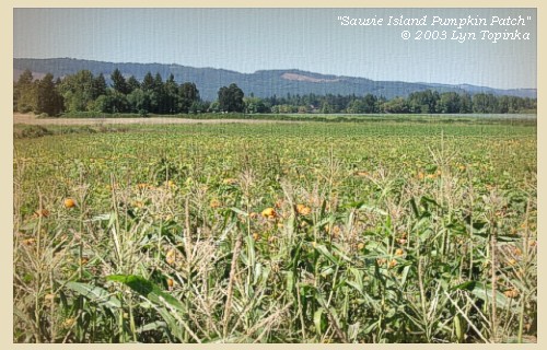
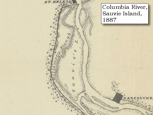
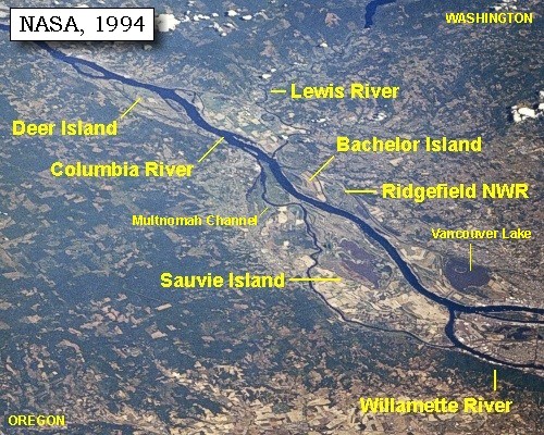
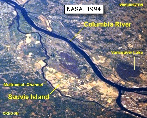
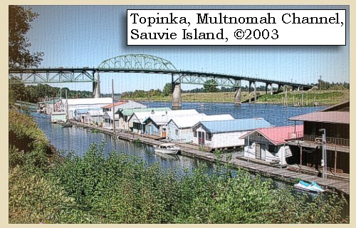
Sauvie Island:
Sauvie Island contains approximately 24,000 acres of land and lakes, and had its origin in alluvial deposits from the Columbia and Willamette rivers as their velocities decreased by changes in direction and by lava extrusions located on the north end. The island is 16 miles long and 4.5 miles at the widest point. The Sauvie Island wildlife area includes 8,053 acres of deeded land and 3,490 acres of land leased from the Division of State Lands for wildlife management purposes. The island is bounded on the east by the Columbia River; on the south by the Willamette River and on the west by the Multnomah Channel. Across the river on the Washington side, Scappoose Bay provides fish and wildlife habitat. -- Columbia Basin Fish and Wildlife Authority Website, 2002, Oregon State Archives Website, 2002, and Washington State Historical Society Website, 2002


Map, 1814, Lewis and Clark on the Columbia, click to enlarge Map, 1854, Columbia River, Fort Vancouver area, click to enlarge Map, 1887, Sauvie Island vicinity, click to enlarge NASA Image, 1994, Columbia River, Deer Island to the Willamette River, click to enlarge NASA Image, 1994, Columbia River upstream of Vancouver, showing Sauvie Island, click to enlarge NASA Image, 1992, Columbia River with Portland, Oregon, and Vancouver, Washington, click to enlarge NASA Image, 1992, Columbia River upstream of Vancouver, showing Sauvie Island, click to enlarge Image, 2003, Multnomah Channel and Sauvie Island Bridge Image, 2003, Sauvie Island
  1. 1814 Map, Lewis and Clark (section of original). (Click to enlarge.) Shows Sauvie Island ("Wapato I."). From the "Nicholas Biddle/Paul Allen" 1814 publication. Original Map: "A Map of Lewis and Clark's Track, Across the Western Portion of North America, From the Mississippi to the Pacific Ocean". From: History of the expedition under the command of Captains Lewis and Clark : to the sources of the Missouri, thence across the Rocky Mountains and down the river Columbia to the Pacific Ocean : performed during the years 1804-5-6 : by order of the government of the United States / prepared for the press by Paul Allen. Philadelphia : Bradford and Insskeep, 1814. Harold B. Lee Library, Brigham Young University #upbover maps37. -- Brigham Young University, Harold B. Lee Library Website, 2004.
  2. 1853-54 Map, Columbia River, including the Fort Vancouver area (section of original). (Click to enlarge). Sauvie Island is depicted but not named. Includes Longview, Washington (Monticello), Coweeman River (Minter R.), Kalama River (Ca-la-ma R.), Lewis River (Cath-la-pootle R.), Willamette River, Fort Vancouver, Cape Horn, and "The Cascades". Vancouver Lake is depicted but not labeled. Original Map: "Rocky Mountains to Puget Sound : from explorations and surveys / made under the direction of the Hon. Jefferson Davis, Secretary of War by Isaac I. Stevens Governor of Washington Territory, 1853-4." Inset: (Supplementary sketch) Reconnaissance of the railroad route from Wallawalla to Seattle via Yak-e-mah River & Snoqualmie Pass. By A. W. Tinkham in January 1854. Drawn by J. R. P. Mechlin. 20 x 28 cm. Topographer, John Lambert, Published in Washington D.C., 1859, 1:1,200,000, Notes: From the U.S. War Department, Explorations and Surveys for a Railroad Route from the Mississippi River to the Pacific Ocean, Topographical Maps, to Illustrate the Various Reports, U.S. Library of Congress American Memories Reference "LC Railroad Maps #156". -- U.S. Library of Congress, American Memories Website, 2004
  3. 1887 Map (section of original), Columbia River and the Sauvie Island vicinity. (Click to enlarge). Bachelor Island, while not named on the map, is the island south (below) the Lewis River. Original Map: The Columbia River from Celilo to the mouth showing locations of the salmon fisheries, 1887. Scale ca. 1:375,000, Relief shown by hachures. U.S. Army Corps of Engineers, Engineer Office, G.P.O. 1888. University of Washington Archives #UW128. -- University of Washington Library Archives Website, 2002
  4. 1994, NASA Image, Columbia River from Deer Island to the Willamette River (section of original). (Click to enlarge). View from space - north-northeast-looking, low-oblique photograph, showing a section of the Columbia River from Deer Island to the Willamette River, including the Lewis River, Sauvie Island, Bachelor Island, and the Ridgefield National Wildlife Refuge, October 1994. The Columbia River is flowing from lower right to upper left in this image (southeast to northwest). Washington State is the upper right of the image and Oregon is to the bottom left. NASA Earth from Space #STS068-262-025. -- NASA Earth from Space Website, 2002
  5. 1994, NASA Image, Columbia River and Sauvie Island (section of original). (Click to enlarge). View from space - north-northeast-looking, low-oblique photograph, showing a section of the Columbia River and Sauvie Island, Oregon, October 1994. NASA Earth from Space #STS068-262-025. -- NASA Earth from Space Website, 2002
  6. 1992, NASA Image, Columbia River, Portland, Oregon, and Vancouver, Washington (section of original). (Click to enlarge). View from space - west-looking, low-oblique photograph, showing a section of the Columbia River with Government Island, the Sandy River, Portland, Oregon, and Vancouver, Washington, September 1992. The Columbia River is flowing from bottom (east) to top (west). NASA Earth from Space #STS047-096-066. -- NASA Earth from Space Website, 2002
  7. 1992, NASA Image, Columbia River upstream of Vancouver, Washington, showing Bachelor Island and the Ridgefield National Wildlife Refuge (section of original). (Click to enlarge). View from space - west-looking, low-oblique photograph, showing a section of the Columbia River upstream of Vancouver, Washington, September 1992. Bachelor Island is on the right side of the image, just barely discernible as an island (light colored yellowish area). Bachelor Island Slough separates Bachelor Island from the mainland. The area next to the Columbia on the right and the left side of Bachelor Island is part of the Ridgefield National Wildlife Refuge. The upper half of the image is Sauvie Island, with the Willamette River on it's left, the Columbia River on the bottom, and the Multnomah Channel on the upper side. NASA Earth from Space #STS047-096-066. -- NASA Earth from Space Website, 2002
  8. 2003, Multnomah Channel and Sauvie Island Bridge, taken from Oregon Highway 30. (Click to enlarge). Copyright © 2003 Lyn Topinka, private archives, used with permission.
  9. 2003, Sauvie Island pumpkin patch. (Click to enlarge). Copyright © 2003 Lyn Topinka, private archives, used with permission.


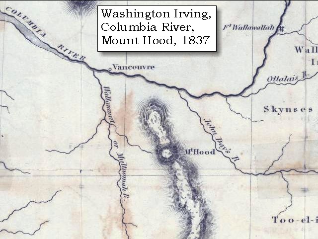
at which place we had a full view of the mountain which we first saw on the 19th of October, from the Muscleshell rapid [Umatilla Rapids], and which we now find to be the mount St. Helen of Vancouver. It bears north 25o east, about ninety miles distant; it rises in the form of a sugar loaf to a very great height, and is covered with snow.
"... (Encamped on the Lard. Side. Mt. Ranier) Mount Hellen bears N. 25o E about 80 miles, this is the mountain we Saw near the forks of this river. it is emensely high and covered with Snow, riseing in a kind of Cone perhaps the highest pinecal from the common leavel in america ..." [Clark, November 4, 1805, first draft]
"... at 3 miles lower, and 12 Leagues below quick Sand river passed a village of four large houses on The Lard. Side, near which we had a full view of 'Mt. Helien' which is perhaps the highest pinical in America from their base it bears N. 25o. E. about 90 miles -- This is the mountain I Saw from the Muscle Shell rapid on the 19th of October last Covered with Snow, it rises Something in the form of a Sugar lofe -- ..." [Clark, November 4, 1805]

Initially in this passage William Clark refers to this mountain as Mount Rainier, and then corrects himself when both became visible further downstream. His correction however was still in error, as he refers to Mount St. Helens being the mountain they viewed on October 19, 1805, near the junction of the Snake River with the Columbia, when in reality that mountain was Mount Adams. The Gass, Ordway, and Whitehouse Journals make no correction and all refer to Mount St. Helens as Mount Rainier.

"... We went 28 miles and encamped on the north side. In the evening we saw Mount Rainy on the same side. It is a handsome point of a mountain, with little or no timber on it, very high, and a considerable distance off this place. ..." [Gass, November 4, 1805]
"... we discovred a high round mountain Some distance back from the River on the Stard Side which is called mount rainy ..." [Ordway, November 4, 1805]
"... we discovered a high round mountain some dis back from the River on Stard. Side which is called mount Rainy. we are not yet out of Site of Mount Hood which is covd. with Snow ..." [Whitehouse, November 4, 1805]
"... We discovered a mountain, which lay on the North side of the River, some distance back from it. It appeared to be round, and is called Mount Rainey . We are not yet out of sight of Mount Hood, which from this place appears to be covered with Snow. ..." [Whitehouse, November 4, 1805]


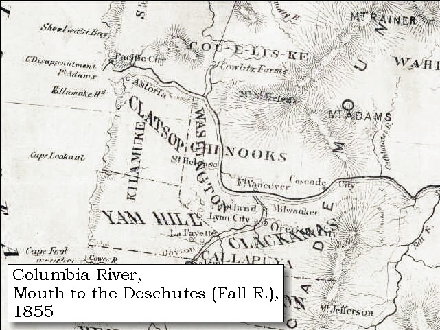
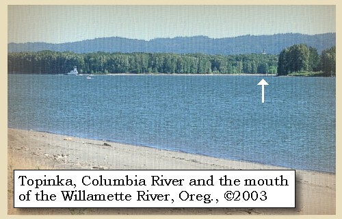
On a clear day FIVE VOLCANOES can be seen along this stretch of the river.


Along the Journey - November 4, 1805
Mount Jefferson from Blurock Landing, 2003

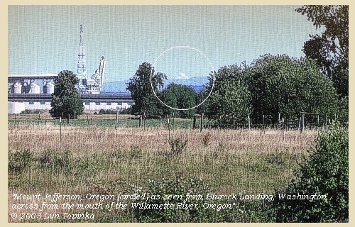
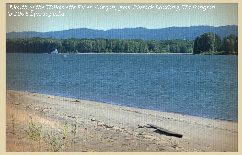
Mount Jefferson, Oregon, (circled):
as seen from Blurock Landing, Washington. Blurock Landing is across the Columbia River from the mouth of the Willamette River, Oregon. Copyright © 2003 Lyn Topinka, private archives, used with permission.

Mount Hood from Blurock Landing, 2003

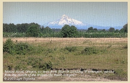
Mount Hood, Oregon:
as seen from Blurock Landing, Washington. Blurock Landing is across the Columbia River from the mouth of the Willamette River, Oregon. Copyright © 2003 Lyn Topinka, private archives, used with permission.

Mount St. Helens from Blurock Landing, 2003

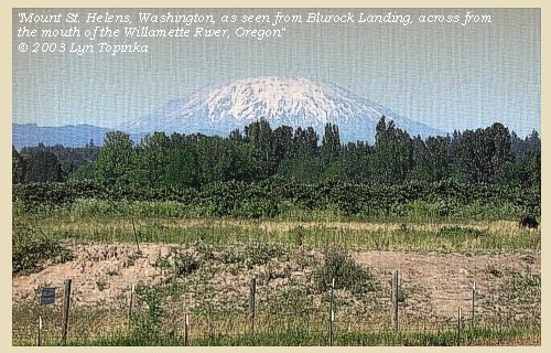
Mount St. Helens, Washington:
as seen from Blurock Landing, Washington. Blurock Landing is across the Columbia River from the mouth of the Willamette River, Oregon. Copyright © 2003 Lyn Topinka, private archives, used with permission.

Mount Adams from Blurock Landing, 2003

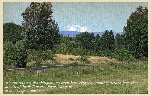
Mount Adams, Washington:
as seen from Blurock Landing, Washington. Blurock Landing is across the Columbia River from the mouth of the Willamette River, Oregon. Copyright © 2003 Lyn Topinka, private archives, used with permission.

Mount Rainier from Blurock Landing, 2003

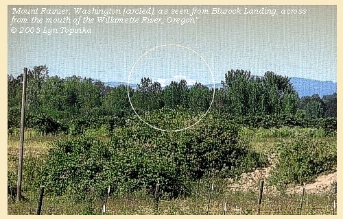
Mount Rainier, Washington:
as seen from Blurock Landing, Washington. Blurock Landing is across the Columbia River from the mouth of the Willamette River, Oregon. Copyright © 2003 Lyn Topinka, private archives, used with permission.


A mile lower we passed a single house on the left, and another on the right. [Vancouver Lake vicinity]


Along the Journey - November 4, 1805
Vancouver Lake County Park with Mount St. Helens, 2003

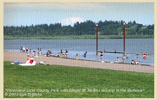
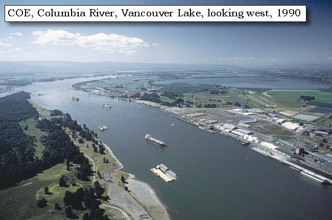
Vancouver Lake:
Vancouver Lake lies just north and west of Vancouver, Washington. Vancouver Lake County Park is a 234-acre park, bordering Vancouver Lake for 2.5 miles, with thirty-five acres of developed land. Picnicking, play structure, windsurfing, and sand volleyball number among the activities that can be enjoyed here. Swimming is allowed in a cordoned swimming area. No lifeguards are on duty. In addition, Vancouver Lake is the site of many college and professional rowing competitions during the year. Vancouver Lake County Park is also a wetlands haven for wildlife and migratory waterfowl. There are good views of Mount St. Helens, Mount Adams, and Mount Hood from Vancouver Lake. On a clear day, Mount Rainier and Mount Jefferson can also be seen. -- Vancouver Parks and Recreation Website, 2003


Map, 1854, Columbia River, Fort Vancouver area, click to enlarge Map, 1988, Mouth of the Willamette and Vancouver Lake, click to enlarge NASA Image, 1992, Columbia River at the Mouth of the Willamette, click to enlarge Image, 1990, Columbia River looking west, Vancouver Lake, click to enlarge Image, 2003, Vancouver Lake and Mount St. Helens
  1. 1853-54 Map, Columbia River, including the Fort Vancouver area (section of original). (Click to enlarge). Vancouver Lake is depicted but not named. Also depicted but not named is Sauvie Island, across the Columbia from Vancouver Lake. Includes Longview, Washington (Monticello), Coweeman River (Minter R.), Kalama River (Ca-la-ma R.), Lewis River (Cath-la-pootle R.), Willamette River, Fort Vancouver, Cape Horn, and "The Cascades". Original Map: "Rocky Mountains to Puget Sound : from explorations and surveys / made under the direction of the Hon. Jefferson Davis, Secretary of War by Isaac I. Stevens Governor of Washington Territory, 1853-4." Inset: (Supplementary sketch) Reconnaissance of the railroad route from Wallawalla to Seattle via Yak-e-mah River & Snoqualmie Pass. By A. W. Tinkham in January 1854. Drawn by J. R. P. Mechlin. 20 x 28 cm. Topographer, John Lambert, Published in Washington D.C., 1859, 1:1,200,000, Notes: From the U.S. War Department, Explorations and Surveys for a Railroad Route from the Mississippi River to the Pacific Ocean, Topographical Maps, to Illustrate the Various Reports, U.S. Library of Congress American Memories Reference "LC Railroad Maps #156". -- U.S. Library of Congress, American Memories Website, 2004
  2. 1988 Map, Mouth of the Willamette River and Vancouver Lake (section of original). (Click to enlarge). Office of Coast Surveys, Historical Maps and Charts, Columbia River, Saint Helens to Vancouver, 1988, Chart#18524, 1:40,000. -- NOAA Office of Coast Survey Website, 2004
  3. 1992, NASA Image, Columbia River at the mouth of the Willamette (section of original). (Click to enlarge). View from space - West-looking, low-oblique photograph, showing a section of the Columbia River with Government Island, September 1992. Portland, Oregon is to the left and Vancouver, Washington is to the right. NASA Earth from Space #STS047-096-066. -- NASA Earth from Space Website, 2002
  4. 1990, Aerial view, Columbia River looking west, with Vancouver Lake on the right. (Click to enlarge). Columbia River at Portland and Vancouver, looking west. Oregon is to the left and Washington State is to the right. Vancouver Lake is on the right. Photographer: Bob Heims. Photograph Date: June 21, 1990. U.S. Army Corps of Engineers Photo Archives #Col0502.jpg -- U.S. Army Corps of Engineers Photo Archives Website, 2003
  5. 2003, Vancouver Lake County Park with Mount St. Helens in the distance. (Click to enlarge). Copyright © 2003 Lyn Topinka, private archives, used with permission.


The Indians had now learnt so much of us, that their curiosity was without any mixture of fear, and their visits became very frequent and troublesome. We therefore continued on till after night, in hopes of getting rid of them; but after passing a village on each side, which on account of the lateness of the hour we saw indistinctly, we found there was no escaping from their importunities. We therefore landed at the distance of seven miles below Image canoe island [Hayden Island], and encamped [in Ridgefield National Wildlife Refuge] near a single house on the right, having made during the day twenty-nine miles. ......


Along the Journey - November 4, 1805
Ridgefield National Wildlife Refuge, 2003

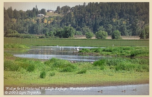
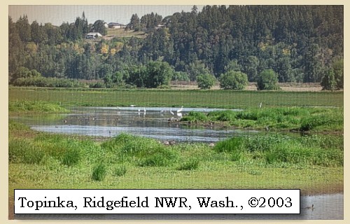
Ridgefield National Wildlife Refuge:
The Ridgefield National Wildlife Refuge Complex is comprised of five refuges located in the southwest part of the state of Washington: Ridgefield north of Vancouver; Conboy in the southcentral part of the state; and Franz Lake, Pierce and Steigerwald Lake all located in the Columbia River Gorge. The refuge north of Vancouver, Washington, was established in 1965 in response to a need to establish vital winter habitat for the dusky Canada goose whose nesting areas in Alaska were severly impacted by the violent earthquake of 1964. This refuge is the location of two Lewis and Clark campsites (November 4, 1805 and March 29, 1806), and is an ancient Chinook townsite visited by the Expedition. In their journals, Lewis and Clark described the wapato plants that were harvested by the Chinook women, as well as, the geese and ducks that kept them awake at night. These species are still here today. Trails, auto tour, and wildlife viewing. Located 14 miles north of Vancouver, Washington. -- U.S. Fish and Wildlife Service Website, 2002, Lewis and Clark Bicentennial Website, 2002, and Lewis and Clark Bicentennial in Oregon Website, 2002


Map, 1887, Lewis River vicinity, click to enlarge NASA Image, 1994, Columbia River, Deer Island to the Willamette River, click to enlarge Image, 2003, Ridgefield National Wildlife Refuge
  1. 1887 Map (section of original), Columbia River and the Lewis River vicinity. (Click to enlarge). Today's Ridgefield National Wildlife Refuge is located below the Lewis River. Original Map: The Columbia River from Celilo to the mouth showing locations of the salmon fisheries, 1887. Scale ca. 1:375,000, Relief shown by hachures. U.S. Army Corps of Engineers, Engineer Office, G.P.O. 1888. University of Washington Archives #UW128. -- University of Washington Library Archives Website, 2002
  2. 1994, NASA Image, Columbia River from Deer Island to the Willamette River (section of original). (Click to enlarge). View from space - north-northeast-looking, low-oblique photograph, showing a section of the Columbia River from Deer Island to the Willamette River, including the Lewis River, Sauvie Island, Bachelor Island, and the Ridgefield National Wildlife Refuge, October 1994. The Columbia River is flowing from lower right to upper left in this image (southeast to northwest). Washington State is the upper right of the image and Oregon is to the bottom left. NASA Earth from Space #STS068-262-025. -- NASA Earth from Space Website, 2002
  3. 2003, Ridgefield National Wildlife Refuge. (Click to enlarge). Copyright © 2003 Lyn Topinka, private archives, used with permission.


Along the Journey - November 4, 1805
The Camp - November 4, 1805:
In today's Ridgefield National Wildlife Refuge.


Home Previous Continue


If you have questions or comments please contact: GS-CVO-WEB@usgs.gov
June/July 2004, Lyn Topinka
The Volcanoes of Lewis and Clark Home Page | CVO Home Page