The Volcanoes of
Lewis and Clark
December 1 - 6, 1805
Looking for a Place to Winter - At Tongue Point
 
Home
The Volcanoes of Lewis and Clark

Map of the Journey
Volcanoes, Basalt Plateaus, Major Rivers, etc.

The Volcanoes
Mount Adams, Mount Hood, Mount Jefferson, Mount Rainier, and Mount St. Helens

CALENDAR of the Journey
October 1805 to June 1806

Along the Journey
Pacific Northwest Maps - Columbia River, Volcanoes, Flood Basalts, Missoula Floods, Geology, etc.

The Corps of Discovery
The Journey of Lewis and Clark

About the Reference Materials
The Journals, Biddle/Allen, DeVoto, Gass, Moulton, Topo Maps, and others

USGS Lewis and Clark Links
Links to USGS Websites highlighting the Lewis and Clark Journey

Resources
Publications Referenced and Websites Visited


PREVIOUS

November 26
Looking for a Place to Winter, Pillar Rock to Tongue Point
December 1-6

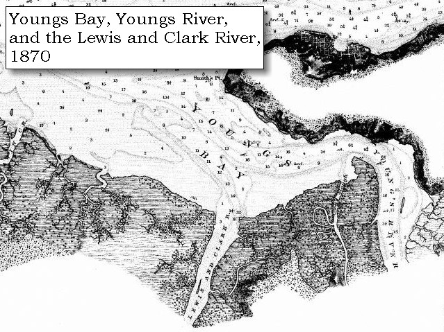
Looking for a Place to Winter,
At Tongue Point

Tongue Point, John Day River (Clatsop County), Lewis and Clark River
CONTINUE

December 7-25
A Place to Winter, Tongue Point to Fort Clatsop
 

On October 7, 1805, Lewis and Clark and the "Corps of Discovery" began their journey down the Clearwater River and into the volcanics of the Pacific Northwest. The Corps travelled from the Clearwater to the Snake and down the "Great Columbia", finally reaching the Pacific Ocean on November 15, 1805. Along the journey they encountered the lava flows of the Columbia Plateau, river channels carved by the great "Missoula Floods", and the awesome beauty of five Cascade Range volcanoes.

Map, Lewis and Clark in the Pacific Northwest, click for brief
                         summary
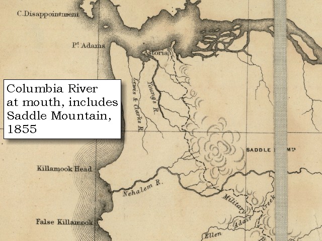
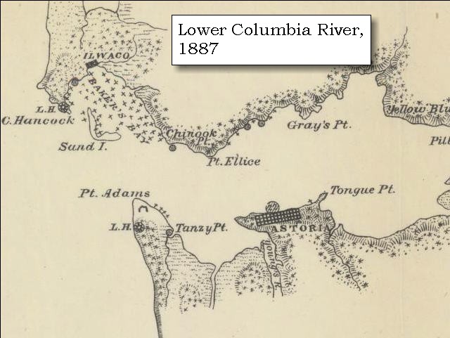
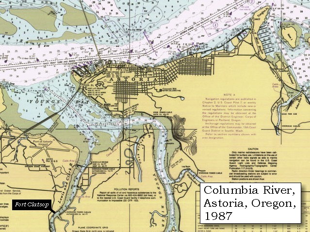
[Click map for brief summary about the area]


At the Pacific - December 1805
Looking for a Place to Winter - At Tongue Point
 

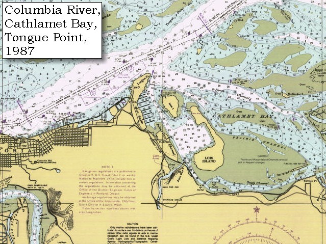
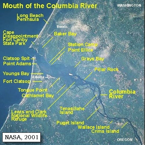
Lewis and Clark's camp from November 27, 1805 to December 6, 1805, was on the west side of the isthmus at Tongue Point, just east of present-day Astoria, Oregon. The majority of the party under Captain Clark remained here until December 7, 1805, while Captain Lewis and five men scouted for a suitable winter camp.

Sunday, December 1, 1805
Again we had a cloudy day, and the wind so high from the east, that having ventured in a boat with a view to hunt at some distance, we were obliged to return [their camp on the west side of the isthmus of Tongue Point].


Along the Journey - December 1, 1805
Tongue Point, 2003

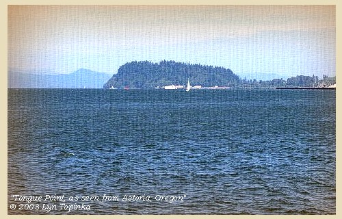
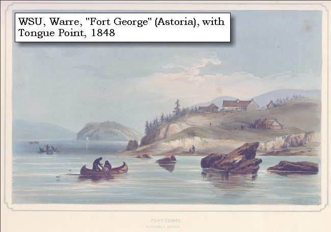
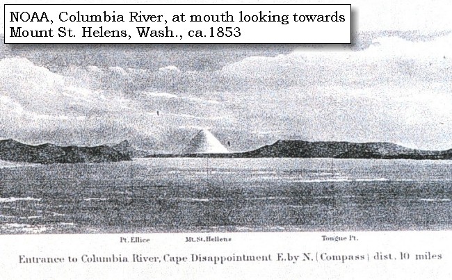
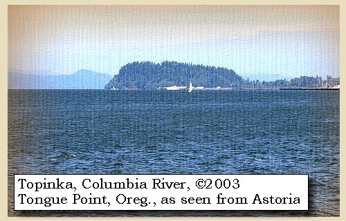
Tongue Point:
Tongue Point, at Columbia River Mile 16 on the Oregon side of the Columbia, is a bold, rocky peninsula, 308 feet high, covered with trees and connected with the south bank by a low, narrow neck. It projects into the river for 0.8 mile. Lewis and Clark named the feature "Point William" after Captain Clark, however it did not stick. Tongue Point was named in 1792 by Lieutenant William Broughton, part of the Vancouver expedition. For ten days in 1805, Captain Clark and some of the men camped on the downstream side of Tongue Point while Captain Lewis, with five men, conducted a reconnaissance of the area and sought a secure location for winter quarters. -- NOAA Office of Coast Survey Website, 2003, and Washington State Historical Society Website, 2004, "Lasting Legacy".


Map, 1814, Lewis and Clark on the Columbia, click to enlarge Map, 1855, Northwest Oregon and mouth Columbia River, click to enlarge Map, 1887, Mouth of the Columbia River, click to enlarge Map, 1987, Youngs Bay, Smith Point, Astoria, click to enlarge Map, 1987, Tongue Point, western part of Cathlamet Bay, click to enlarge Map, 1987, Tongue Point, John Day River, western part of Cathlamet Bay, click to enlarge NASA Image, 2001, Mouth of the Columbia River, click to enlarge Engraving, 1848, Fort George (Astoria), click to enlarge Engraving, ca.1853, Mount St. Helens and the mouth of the Columbia River, click to enlarge Image, 1889, Mount St. Helens and the mouth of the Columbia River, click to enlarge Image, 2003, Tongue Point, Oregon
  1. 1814 Map, Lewis and Clark's map of the Columbia River (section of original). (Click to enlarge.) Astoria, Smith Point, and Tongue Point are depicted but not named. Map includes three of the five volcanoes Lewis and Clark saw and commented on. While the journals mention the expedition seeing Mount Adams, it does not appear on their map. Mount Jefferson is to the south (bottom) and off the map. From the "Nicholas Biddle/Paul Allen" 1814 publication. Original Map: "A Map of Lewis and Clark's Track, Across the Western Portion of North America, From the Mississippi to the Pacific Ocean". From: History of the expedition under the command of Captains Lewis and Clark : to the sources of the Missouri, thence across the Rocky Mountains and down the river Columbia to the Pacific Ocean : performed during the years 1804-5-6 : by order of the government of the United States / prepared for the press by Paul Allen. Philadelphia : Bradford and Insskeep, 1814. Harold B. Lee Library, Brigham Young University #upbover maps37. -- Brigham Young University, Harold B. Lee Library Website, 2004.
  2. 1855 Map, Northwest Oregon and mouth of the Columbia River (section of original). (Click to enlarge). Tongue Point is depicted but not named. Includes the Columbia River, Cape Disappointment, Point Adams, Saddle Mountain, Lewis and Clark River, Youngs River. Original Map: From the northern boundary of California to the Columbia River : from explorations and surveys / made under the direction of Hon. Jefferson Davis, Sec. of War by Lieut. R. S. Williamson, U.S. Topl. Engrs. and Lieut. H. L. Abbot, U.S. Topl. Engrs., H. C. Fillebrown, J. Young, and C. D. Anderson, Assts., 1855. Notes: Scale 1:760,320. Relief shown by hachures. At head of title: Routes in Oregon and California. Map no. 2. "Drawn by John Young." From U.S. War Department, Explorations and Surveys for a Railroad Route from the Mississippi River to the Pacific Ocean. Topographical Maps... to Illustrate the Various Reports... (Washington, 1859) Library of Congress American Memory Archives #G4290 1855 .W5 RR 170. -- U.S. Library of Congress Archives, 2004, "American Memory"
  3. 1887 Map (section of original), Mouth of the Columbia River. (Click to enlarge). Original Map: The Columbia River from Celilo to the mouth showing locations of the salmon fisheries, 1887. Scale ca. 1:375,000, Relief shown by hachures. U.S. Army Corps of Engineers, Engineer Office, G.P.O. 1888. University of Washington Archives #UW128. -- University of Washington Library Archives Website, 2002
  4. 1987 Map, Youngs Bay, Smith Point, Astoria (section of original). (Click to enlarge). Office of Coast Surveys, Historical Maps and Charts, Columbia River, Pacific Ocean to Harrington Point, 1987, Chart#18521, 1:40,000. -- NOAA Office of Coast Survey Website, 2004
  5. 1987 Map, Tongue Point and the western part of Cathlamet Bay (section of original). (Click to enlarge). Office of Coast Surveys, Historical Maps and Charts, Columbia River, Pacific Ocean to Harrington Point, 1987, Chart#18521, 1:40,000. -- NOAA Office of Coast Survey Website, 2004
  6. 1987 Map, Tongue Point, John Day River, and the western part of Cathlamet Bay (section of original). (Click to enlarge). Office of Coast Surveys, Historical Maps and Charts, Columbia River, Pacific Ocean to Harrington Point, 1987, Chart#18521, 1:40,000. -- NOAA Office of Coast Survey Website, 2004
  7. 2001, NASA Image, Mouth of the Columbia River, including Tongue Point. (Click to enlarge). NASA Space Shuttle photograph of the mouth of the Columbia River, including the location of Fort Clatsop, the Lewis and Clark National Wildlife Refuge, Tenasillahe Island, Puget Island, and Crim's Island, June 20, 2001. NASA Astronaut Photography of Earth #SS002-724-30. -- NASA Astronaut Photography of Earth Website, 2002
  8. 1848, Watercolor, Fort George formerly Astoria, 1848. (Click to enlarge). This watercolor view portrays Astoria, Oregon, during the year 1845, by Sir Henry James Warre. Tongue Point is in the middleground. Washington State University Photo Archvies #WSU553. -- Washington State University Library Archives Website, 2002
  9. ca.1853, Engraving, mouth of the Columbia River with Tongue Point and Mount St. Helens (section of original). (Click to enlarge). Engraving depicts the Mouth of the Columbia River, Point Ellice, Mount St. Helens, and Tongue Point (just barely discernable on the right). Original also depicts Cape Disappointment and Point Adams. NOAA Photo Archives, America's Coastline Collection #line2075. -- NOAA Photo Archvies Website, 2002
  10. 1889, Engraving/Sketch. Mouth of the Columbia River (section of original). (Click to enlarge). Engraving depicts the Mouth of the Columbia River, Point Ellice, Mount St. Helens, and Tongue Point. Original also depicts Scarborough Hill. From: NOAA Library, Pacific Coast Coast Pilot of California, Oregon, and Washington, 1889 -- NOAA Photo Archives Website, 2004
  11. 2003, Tongue Point, as seen from Astoria, Oregon. (Click to enlarge). Copyright © 2003 Lyn Topinka, private archives, used with permission.


We resumed our occupation of dressing leather and mending our old clothes, in which we passed the day. The hunters came in with a report of their having seen two herds of elk, but they could kill nothing, and we therefore again fed upon dried fish. At sunset it began to rain violently, and continued all night ......


Along the Journey - December 1, 1805
The Camp - November 27 through December 6, 1805
On the west side of Tongue Point, just east of present-day Astoria, Oregon. The majority of the party under Captain Clark remained here until December 7, 1805, while Captain Lewis and five men scouted for a suitable winter camp.


Monday, December 2, 1805
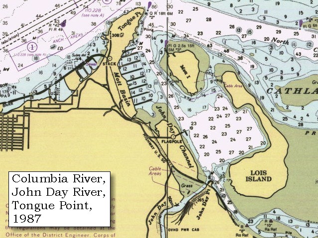
This disagreeable food, pounded fish, has occasioned so much sickness among the men that it is now absolutely necessary to vary it. Three hunters therefore set out, and three more were sent up the Kekemahke creek [John Day River, Clatsop County, Oregon] in search of fish or birds.


Along the Journey - December 2, 1805
Map, John Day River (Clatsop County), 1890

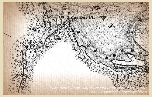
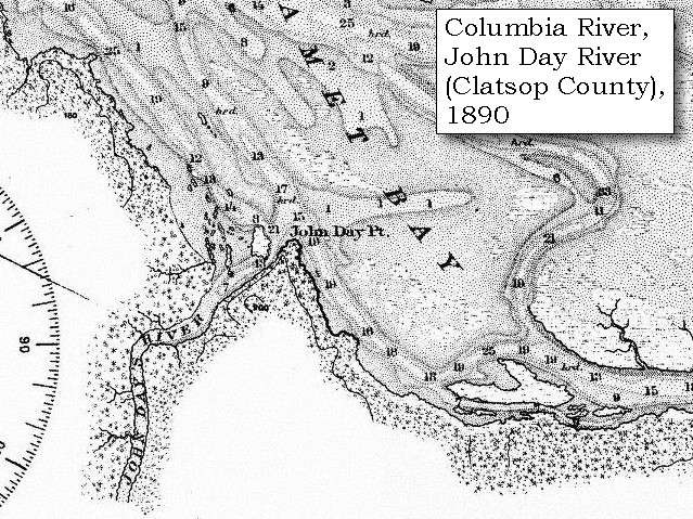
John Day River, Clatsop County, Oregon:
Lewis and Clark refered to Clastsop County's John Day River as "Ke-ke mar que Creek", a word obtained from the local indians. They did not comprehend that Pacific Northwest Indians did not name geographical features such as rivers and creeks; instead, they identified sites on the drainages. This concept was also foreign to later cartographers. Their translations of native languages led to many misconceptions of actual Indian meanings and names. This western Oregon river, like the one in eastern Oregon, was named for John Day of Wilson Price Hunt's Astorian overland expedition, 1811-12. -- Washington State Historical Society Website, 2002


Map, 1814, Lewis and Clark on the Columbia, click to enlarge Map, 1887, Columbia River from mouth to Pillar Rock, click to enlarge Map, 1890, John Day River and John Day Point, click to enlarge Map, 1987, Tongue Point, John Day River, western part of Cathlamet Bay, click to enlarge
  1. 1814 Map, Lewis and Clark's map of the Columbia River (section of original). (Click to enlarge.) The John Day River is depicted emptying into Cathlamet Bay (depicted but not named, full of islands) but is not named. Map also includes three of the five volcanoes Lewis and Clark saw and commented on. While the journals mention the expedition seeing Mount Adams, it does not appear on their map. Mount Jefferson is to the south (bottom) and off the map. From the "Nicholas Biddle/Paul Allen" 1814 publication. Original Map: "A Map of Lewis and Clark's Track, Across the Western Portion of North America, From the Mississippi to the Pacific Ocean". From: History of the expedition under the command of Captains Lewis and Clark : to the sources of the Missouri, thence across the Rocky Mountains and down the river Columbia to the Pacific Ocean : performed during the years 1804-5-6 : by order of the government of the United States / prepared for the press by Paul Allen. Philadelphia : Bradford and Insskeep, 1814. Harold B. Lee Library, Brigham Young University #upbover maps37. -- Brigham Young University, Harold B. Lee Library Website, 2004.
  2. 1887 Map, Columbia River from the Mouth to Pillar Rock (section of original). (Click to enlarge). The John Day River (right of Tongue Point) is depicted but not named. Original Map: The Columbia River from Celilo to the mouth showing locations of the salmon fisheries, 1887. Scale ca. 1:375,000, Relief shown by hachures. U.S. Army Corps of Engineers, Engineer Office, G.P.O. 1888. University of Washington Archives #UW128. -- University of Washington Library Archives Website, 2004
  3. 1890 Map (section of original), John Day River and John Day Point. (Click to enlarge). Office of Coast Surveys, Historical Maps and Charts, Columbia River, Columbia River, Sheet No.2, 1890, Chart #6141, Plate No.1454, 1:40,000. -- NOAA Office of Coast Survey Website, 2004
  4. 1987 Map, Tongue Point, John Day River, and the western part of Cathlamet Bay (section of original). (Click to enlarge). Office of Coast Surveys, Historical Maps and Charts, Columbia River, Pacific Ocean to Harrington Point, 1987, Chart#18521, 1:40,000. -- NOAA Office of Coast Survey Website, 2004


Towards evening one of them returned: he had observed great appearances of elk, and even seen two herds of them; but it rained so hard that he could with difficulty get a shot: he had, however, at last killed one, at the distance of six miles from the camp, and a canoe was now sent to bring it. The party from Kekemahke creek [John Day River, Clatsop County, Oregon] were less successful: they had seen no fish, and all the birds, in consequence probably of being much hunted by the Indians, were too shy to be approached.


Along the Journey - December 2, 1805
The Camp - November 27 through December 6, 1805
On the west side of Tongue Point, just east of present-day Astoria, Oregon. The majority of the party under Captain Clark remained here until December 7, 1805, while Captain Lewis and five men scouted for a suitable winter camp.


Tuesday, December 3, 1805
The wind was from the east, and the morning fair; but, as if a whole day of fine weather was not permitted, towards night it began to rain. Even this transient glimpse of sunshine revived the spirits of the party, who were still more pleased, when the elk killed yesterday was brought into camp. This was the first elk we had killed on the west side of the Rocky mountains, and condemned as we have been to the dried fish, forms a most nourishing food. After eating the marrow of the shank-bones, the squaw chopped them fine, and by boiling, extracted a pint of grease, superior to the tallow itself of the animal. A canoe of eight Indians, who were carrying down wappatoo roots to trade with the Clatsops, stopped at our camp: we bought a few roots for small fish-hooks, and they then left us: but accustomed as we are to the sight, we could not but view with admiration the wonderful dexterity with which they guide their canoes over the most boisterous seas; for though the waves were so high, that before they had gone half a mile the canoe was several times out of sight, they proceeded with the greatest calmness and security. Two of the hunters who set out yesterday had lost their way, and did not return till this evening: they had seen in their ramble great signs of elk, and had killed six elk, which they had butchered and left at a great distance. A party was sent in the morning,


Along the Journey - December 3, 1805
The Camp - November 27 through December 6, 1805
On the west side of Tongue Point, just east of present-day Astoria, Oregon. The majority of the party under Captain Clark remained here until December 7, 1805, while Captain Lewis and five men scouted for a suitable winter camp.


Wednesday, December 4, 1805
to carry the elk to a bay, some distance below, to which place, if the weather permitted, we would all remove our camp this evening; but the rain which had continued during the night lasted all next day, and was accompanied by so high a wind from the southeast and south, that we dared not risk our canoes on the water. It was high water at eleven o'clock, when the spring-tide rose two feet higher than the common flood-tides. We passed the day around our fires, and as we are so situated that the smoke will not immediately leave the camp, we are very much incommoded, and our eyes injured by it. No news has yet been received from captain Lewis, and we begin to have much uneasiness for his safety.


Along the Journey - December 4, 1805
The Camp - November 27 through December 6, 1805
On the west side of Tongue Point, just east of present-day Astoria, Oregon. The majority of the party under Captain Clark remained here until December 7, 1805, while Captain Lewis and five men scouted for a suitable winter camp.


Thursday, December 5, 1805
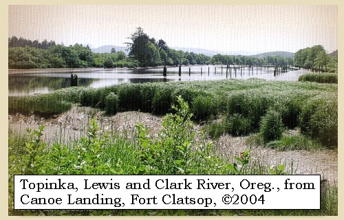
It rained during the whole night, and this morning the rain and high wind compelled us to remain at our camp. Besides the inconvenience of being thus stopped on our route, we now found that all our stores and bedding are again wet with rain. The high water was at twelve o'clock, and rose two inches beyond that of yesterday. In the afternoon we were rejoiced at the return of captain Lewis, who came in a canoe with three of his men, the other two being left to guard six elk and five deer which they had killed: he had examined the coast, and found a river a short distance below [Lewis and Clark River], on which we might encamp during the winter, with a sufficiency of elk for our subsistence within reach.


Along the Journey - December 5, 1805
Lewis and Clark River from Fort Clatsop, 2004

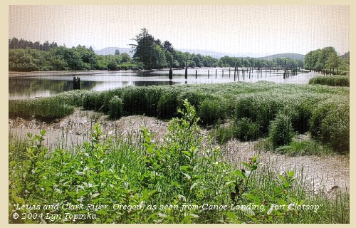
Lewis and Clark River:
Lewis and Clark called this river by the Indian word "Netul". "Fort River" was also used in the journals. Fort Clatsop, the 1805-06 winter camp of Lewis and Clark was located on the left bank of the Lewis and Clark River. -- Washington State Historical Society Website, 2004, "Lasting Legacy"


Map, 1814, Lewis and Clark on the Columbia, click to enlarge Map, 1855, Northwest Oregon and mouth Columbia River, click to enlarge Map, 1870, Youngs Bay, Lewis and Clark River, Youngs River, click to enlarge Map, 1887, Columbia River from mouth to Pillar Rock, click to enlarge Map, 1987, Youngs Bay, Smith Point, Astoria, click to enlarge Image, 2004, Lewis and Clark River, as seen from Fort Clatsop
  1. 1814 Map, Lewis and Clark's map of the Columbia River (section of original). (Click to enlarge.) The Lewis and Clark River is depicted but not named. The location of Fort Clatsop is shown on the Lewis and Clark River. Map includes three of the five volcanoes Lewis and Clark saw and commented on. While the journals mention the expedition seeing Mount Adams, it does not appear on their map. Mount Jefferson is to the south (bottom) and off the map. From the "Nicholas Biddle/Paul Allen" 1814 publication. Original Map: "A Map of Lewis and Clark's Track, Across the Western Portion of North America, From the Mississippi to the Pacific Ocean". From: History of the expedition under the command of Captains Lewis and Clark : to the sources of the Missouri, thence across the Rocky Mountains and down the river Columbia to the Pacific Ocean : performed during the years 1804-5-6 : by order of the government of the United States / prepared for the press by Paul Allen. Philadelphia : Bradford and Insskeep, 1814. Harold B. Lee Library, Brigham Young University #upbover maps37. -- Brigham Young University, Harold B. Lee Library Website, 2004.
  2. 1855 Map, Northwest Oregon and mouth of the Columbia River (section of original). (Click to enlarge). Includes the Columbia River, Cape Disappointment, Point Adams, Saddle Mountain, Lewis and Clark River, Youngs River. Original Map: From the northern boundary of California to the Columbia River : from explorations and surveys / made under the direction of Hon. Jefferson Davis, Sec. of War by Lieut. R. S. Williamson, U.S. Topl. Engrs. and Lieut. H. L. Abbot, U.S. Topl. Engrs., H. C. Fillebrown, J. Young, and C. D. Anderson, Assts., 1855. Notes: Scale 1:760,320. Relief shown by hachures. At head of title: Routes in Oregon and California. Map no. 2. "Drawn by John Young." From U.S. War Department, Explorations and Surveys for a Railroad Route from the Mississippi River to the Pacific Ocean. Topographical Maps... to Illustrate the Various Reports... (Washington, 1859) Library of Congress American Memory Archives #G4290 1855 .W5 RR 170. -- U.S. Library of Congress Archives, 2004, "American Memory"
  3. 1870 Map (section of original), Youngs Bay, Lewis and Clark River, and Youngs River. (Click to enlarge). Office of Coast Surveys, Historical Maps and Charts, Columbia River, Columbia River, Sheet No.1, 1870, Plate No.1130, 1:40,000. -- NOAA Office of Coast Survey Website, 2004
  4. 1887 Map, Columbia River from the Mouth to Pillar Rock (section of original). (Click to enlarge). The Lewis and Clark River (left of Young's R.) is depicted but not named. Original Map: The Columbia River from Celilo to the mouth showing locations of the salmon fisheries, 1887. Scale ca. 1:375,000, Relief shown by hachures. U.S. Army Corps of Engineers, Engineer Office, G.P.O. 1888. University of Washington Archives #UW128. -- University of Washington Library Archives Website, 2004
  5. 1987 Map, Youngs Bay, Smith Point, Astoria (section of original). (Click to enlarge). Office of Coast Surveys, Historical Maps and Charts, Columbia River, Pacific Ocean to Harrington Point, 1987, Chart#18521, 1:40,000. -- NOAA Office of Coast Survey Website, 2004
  6. 2004, Lewis and Clark River, as seen from Fort Clatsop. (Click to enlarge). Copyright © 2004 Lyn Topinka, private archives, used with permission.


This information was very satisfactory, and we decided on going thither as soon as we could move from the point [Tongue Point]; but all night and the following day,


Along the Journey - December 5, 1805
The Camp - November 27 through December 6, 1805
On the west side of Tongue Point, just east of present-day Astoria, Oregon. The majority of the party under Captain Clark remained here until December 7, 1805, while Captain Lewis and five men scouted for a suitable winter camp.


Friday, December 6, 1805
it rained, and the wind blew hard from the southwest, so that the sea was still too rough for us to proceed. The high-tide of to-day rose thirteen inches higher than it did yesterday, and obliged us to move our camp to a high situation. Here we remained waiting for better weather, till about dark the wind shifted to the north, and the sky was clear. We had now some prospect of being able to leave our situation, and indeed although some rain fell in the course of the night, the next morning,


Along the Journey - December 6, 1805
The Camp - November 27 through December 6, 1805
On the west side of Tongue Point, just east of present-day Astoria, Oregon. The majority of the party under Captain Clark remained here until December 7, 1805, while Captain Lewis and five men scouted for a suitable winter camp.


Home Previous Continue


If you have questions or comments please contact: GS-CVO-WEB@usgs.gov
June/July 2004, Lyn Topinka
The Volcanoes of Lewis and Clark Home Page | CVO Home Page