The Volcanoes of
Lewis and Clark
April 2, 1806
Gathering Provisions - Cottonwood Beach and the Willamette River
 
Home
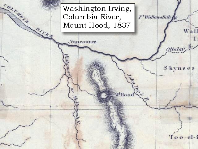
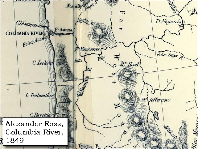
The Volcanoes of Lewis and Clark

Map of the Journey
Volcanoes, Basalt Plateaus, Major Rivers, etc.

The Volcanoes
Mount Adams, Mount Hood, Mount Jefferson, Mount Rainier, and Mount St. Helens

CALENDAR of the Journey
October 1805 to June 1806

Along the Journey
Pacific Northwest Maps - Columbia River, Volcanoes, Flood Basalts, Missoula Floods, Geology, etc.

The Corps of Discovery
The Journey of Lewis and Clark

About the Reference Materials
The Journals, Biddle/Allen, DeVoto, Gass, Moulton, Topo Maps, and others

USGS Lewis and Clark Links
Links to USGS Websites highlighting the Lewis and Clark Journey

Resources
Publications Referenced and Websites Visited


PREVIOUS

April 1
Gathering Provisions, Cottonwood Beach Camp and the Sandy River
April 2

Gathering Provisions,
Cottonwood Beach Camp and the Willamette River

Cottonwood Beach, Willamette River, Portland (Oregon)
CONTINUE

April 3
Five Volcanoes and a Side-Trip Up the Willamette
 

On October 7, 1805, Lewis and Clark and the "Corps of Discovery" began their journey down the Clearwater River and into the volcanics of the Pacific Northwest. The Corps travelled from the Clearwater to the Snake and down the "Great Columbia", finally reaching the Pacific Ocean on November 15, 1805. Along the journey they encountered the lava flows of the Columbia Plateau, river channels carved by the great "Missoula Floods", and the awesome beauty of five Cascade Range volcanoes.

Map, Lewis and Clark in the Pacific Northwest, click for brief
                         summary
[Click map for brief summary about the area]


Heading for Home - April 1806
Gathering Provisions - Cottonwood Beach and the Willamette River
 

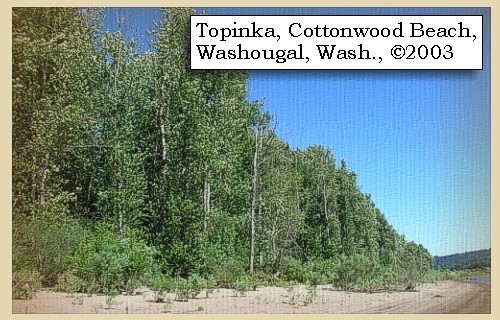
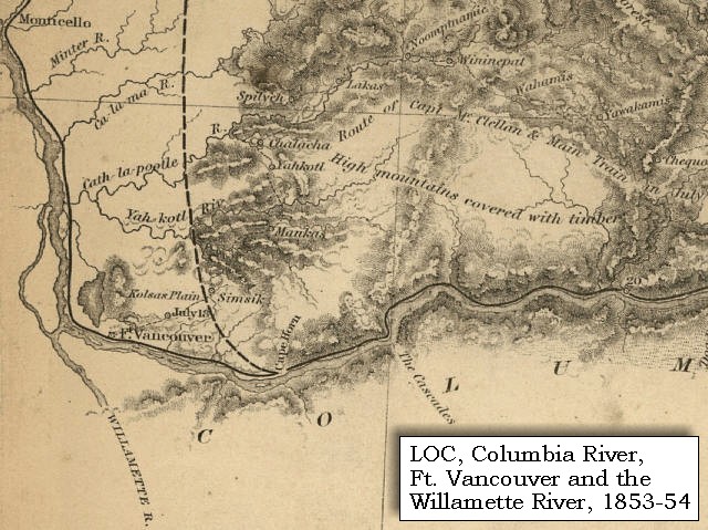
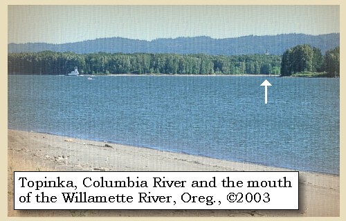
Between March 31 and April 5, 1806 Lewis and Clark camped near present day Cottonwood Beach just upstream of Washougal, Washington. From this campsite, William Clark led a group of men back down the Columbia to discover the Willamette River, which they had missed on both their outward and return voyages.

Wednesday, April 2, 1806
Being now determined to collect as much meat as possible, two parties, consisting of nine men, were sent over the river to hunt, three were ordered to range the country on this side, while all the rest were employed in cutting and scaffolding the meat which we had already.


Along the Journey - April 2, 1806
Cottonwood Beach, 2003

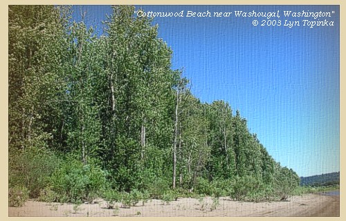
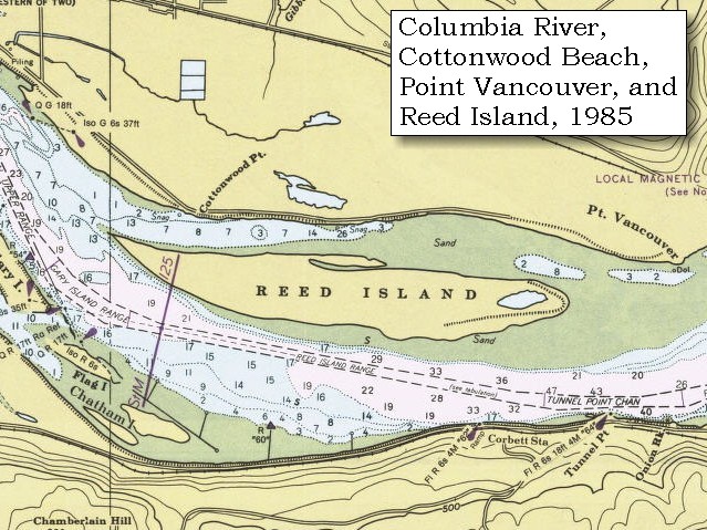
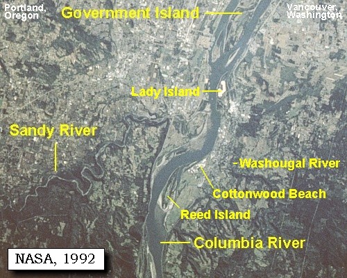
Cottonwood Beach:
Between March 31 and April 5, 1806 the Corps of Discovery camped near present day Cottonwood Beach in Washougal. From this campsite, William Clark also led a group of men back down the Columbia to discover the Willamette River, which they had missed on both their outward and return voyages. Presently, the cities of Washougal and Camas, Port of Camas/Washougal, and the Clark County Parks Department, are collaborating on creating a regional park at this location and it has been named Capt. William Clark Park at Cottonwood Beach. -- City of Washougal, Washington, Website, 2002


Map, 1948, Reed Island, Steigerwald Lake, Cottonwood Point, and Point Vancouver, click to enlarge Map, 1948, Reed Island, Steigerwald Lake, Cottonwood Point, and Point Vancouver, click to enlarge NASA Image, 1992, Columbia River and the Sandy River area, click to enlarge Image, 2003, Cottonwood Beach
  1. 1948 Map, Columbia River with Reed Island, Steigerwald Lake, Cottonwood Point, and Point Vancouver. (Click to enlarge). Cottonwood Beach is downstream (left) of Cottonwood Point. Office of Coast Surveys, Historical Maps and Charts, Columbia River, Vancouver to Bonneville, 1948, Chart#6156, 1:40,000. -- NOAA Office of Coast Survey Website, 2004
  2. 1985 Map (section of original), Reed Island, Steigerwald Lake, Cottonwood Point, and Point Vancouver. (Click to enlarge). Cottonwood Beach is downstream (left) of Cottonwood Point. Office of Coast Surveys, Historical Maps and Charts, Columbia River, Vancouver to Bonneville, 1985, Chart#18531, 1:40,000. -- NOAA Office of Coast Survey Website, 2004
  3. 1992, NASA Image, Columbia River and the Sandy River area (section of original). (Click to enlarge). View from space - west-looking, low-oblique photograph, showing a section of the Columbia River with Government Island, Lady Island, Reed Island, Sandy River, Washougal River, Cottonwood Beach, and Portland, Oregon and Vancouver, Washington, September 1992. The Columbia River is flowing from bottom (east) to top (west). NASA Earth from Space #STS047-096-066. -- NASA Earth from Space Website, 2002
  4. 2003, Cottonwood Beach, near Washougal, Washington. (Click to enlarge). Copyright © 2003 Lyn Topinka, private archives, used with permission.


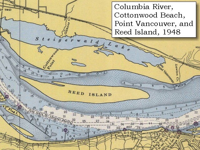
About eight o'clock several canoes arrived to visit us, and among the rest were two young men, who were pointed out as Cashooks. On inquiry, they said that their nation resided at the falls of a large river [Willamette Falls and the Willamette River], which empties itself into the south side of the Columbia, a few miles below us and they drew a map of the country, with a coal on a mat.
"... it appeared that this river which they called Mult-no-mah discharged itself behind the Island which we called the image canoe Island and as we had left this island to the S. both in ascending and decending the river we had never seen it. they informed us that it was a large river and run a considerable distance to the South between the mountains ..." [Lewis, April 2, 1806]
"... The great River is called by the Natives the Mult-no-mack River; it is 500 Yards wide at its mouth; & continues that width, as high up, as where we ascended it. The Indian guide that was with us, told us that it heads Near the head Waters of the California ..." [Whitehouse, April 2, 1806]


Along the Journey - April 2, 1806
Mouth of the Willamette River, 2003

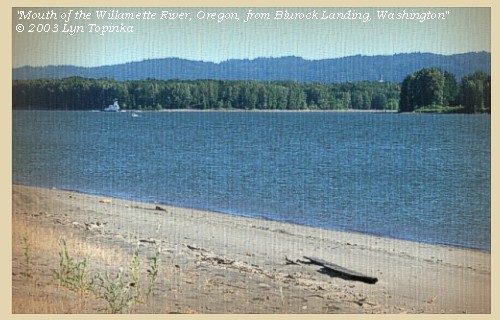
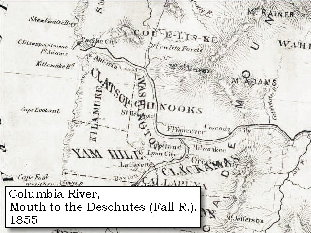
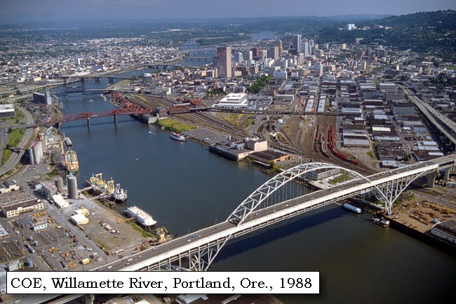
Willamette River:
Most of Oregon's population, technology and agricultural centers, and important transportion, power, and communications lifelines are located in the Willamette Valley of western Oregon. The lowlands of the Willamette Valley extend approximately 75 miles along the Willamette River and contain the major cities of Portland, Salem, Corvallis, and Eugene. The valley is part of the Willamette River drainage basin, which covers 12,300 square miles between the crest of the Oregon Coast Range on the west and the Cascade Range to the east. The Willamette River is the largest river in the valley and is fed by several major tributaries, including the McKenzie, Calapooia, Santiam, Tualatin, Yamhill, and Clakamas Rivers. The valley is the major source of ground and surface water for the population centers. -- Givler and Wells, 2001


Map, 1814, Lewis and Clark on the Columbia, click to enlarge Map, 1833, Illman and Pilbrow, Columbia River, click to enlarge Map, 1837, Columbia River with Mount Hood, click to enlarge Map, 1849, Alexander Ross's Columbia River, click to enlarge Map, 1853, Washington and Oregon and the Columbia River, click to enlarge Map, 1854, Columbia River, Fort Vancouver area, click to enlarge Map, 1855, Columbia River, Vancouver to the Pacific, click to enlarge Map, 1887, Portland and Vancouver vicinity, click to enlarge Map, 1988, Mouth of the Willamette and Vancouver Lake, click to enlarge NASA Image, 1992, Columbia River with Portland, Oregon, and Vancouver, Washington, click to enlarge Image, 2003, Mouth of the Willamette River, Oregon
  1. 1814 Map, Lewis and Clark's map of the Columbia River (section of original). (Click to enlarge.) Shows the Willamette River merging from the south (just left of center). The Lewis and Clark name "Multnomah R." has been cropped in this image. Map also includes three of the five volcanoes Lewis and Clark saw and commented on. While the journals mention the expedition seeing Mount Adams, it does not appear on their map. Mount Jefferson is to the south (bottom) and off the map. From the "Nicholas Biddle/Paul Allen" 1814 publication. Original Map: "A Map of Lewis and Clark's Track, Across the Western Portion of North America, From the Mississippi to the Pacific Ocean". From: History of the expedition under the command of Captains Lewis and Clark : to the sources of the Missouri, thence across the Rocky Mountains and down the river Columbia to the Pacific Ocean : performed during the years 1804-5-6 : by order of the government of the United States / prepared for the press by Paul Allen. Philadelphia : Bradford and Insskeep, 1814. Harold B. Lee Library, Brigham Young University #upbover maps37. -- Brigham Young University, Harold B. Lee Library Website, 2004.
  2. 1833 Map (section of original), Columbia River. (Click to enlarge). Includes Mount Hood and Mount Jefferson. Note: Mount Baker is depicted (upper middle) but Mounts Adams, Rainier and St. Helens are missing. The Columbia River is shown as "Oregon River" at its mouth and "Columbia or Oregon R." further inland. "Wappatoo Valley" is labeled. Also shows Fort Clatsop ("F. Clatsop or F. George"), the Willamette River ("Multnomah R."), Sandy River ("Quicksand R."), John Day River ("R.La Page"), Walla Walla River ("Wallwullah R."), Snake River ("Lewis R."), and the Yakima River ("Tapete R."). Original Map: Oregon Territory, 1833. Creator: Illman & Pilbrow, published by Illman & Pilbrow, New York. Comments: Illman & Pilbrow is the engraving firm which copyrighted and published this map, the actual artist is unknown. Washington State University Digital Maps Collection #WSU323. University of Washington Digital Maps Collection #UW104. -- Washington State University Early Washington Maps Digital Collection Website, 2004
  3. 1837 Map, Columbia River with Mount Hood (section of original). (Click to enlarge). Includes "Wallamant or Multnomah R.". Original Map: Map of the Territory West of the Rocky Mountains (1837) Author: Washington Irving, Publisher: Philadelphia, Carey, Lea, & Blanchard. Washington State University Archives #WSU555. -- Washington State University Early Washington Maps Digital Collection Website, 2004
  4. 1849 Map (section of original), Alexander Ross's Columbia River. (Click to enlarge). Original Map: Map of the Columbia to illustrate Ross's adventures. Author: Alexander Ross; Publication Date: 1849; Publisher: London, Smith, Elder and Co., 1849. Washington State University Archives #WSU478. -- Washington State University Early Washington Maps Digital Collection Website, 2004
  5. 1853 Map, Washington and Oregon and the Columbia River, from the Clearwater River to the Snake River and down the Columbia River to the Pacific Ocean (section of original). (Click to enlarge). Includes: Clearwater River (Kooskooski), Lapwai Creek (Lapwai R.), Snake River (Saptin or Lewis R.), Columbia River (Columbia R.), Yakima River (Yakima R.), Walla Walla River (Wallawalla R.), Umatilla River (Umatilla R.), Willow Creek (Quesnells R.), John Day River (John day's R.), Deschutes River (Fall R.), Willamette River (Willammette R.), and Cowlitz River (Cowlitz R.). Original Map: "Map of California, Oregon, Washington, Utah, and New Mexico (1853)", by Thomas Cowperthwait & Co. Washington State University Archives #WSU22. -- Washington State University Library Collections Website, 2003
  6. 1853-54 Map, Columbia River, including the Fort Vancouver area (section of original). (Click to enlarge). Includes Longview, Washington (Monticello), Coweeman River (Minter R.), Kalama River (Ca-la-ma R.), Lewis River (Cath-la-pootle R.), Willamette River, Fort Vancouver, Cape Horn, and "The Cascades". Vancouver Lake is depicted but not labeled. Original Map: "Rocky Mountains to Puget Sound : from explorations and surveys / made under the direction of the Hon. Jefferson Davis, Secretary of War by Isaac I. Stevens Governor of Washington Territory, 1853-4." Inset: (Supplementary sketch) Reconnaissance of the railroad route from Wallawalla to Seattle via Yak-e-mah River & Snoqualmie Pass. By A. W. Tinkham in January 1854. Drawn by J. R. P. Mechlin. 20 x 28 cm. Topographer, John Lambert, Published in Washington D.C., 1859, 1:1,200,000, Notes: From the U.S. War Department, Explorations and Surveys for a Railroad Route from the Mississippi River to the Pacific Ocean, Topographical Maps, to Illustrate the Various Reports, U.S. Library of Congress American Memories Reference "LC Railroad Maps #156". -- U.S. Library of Congress, American Memories Website, 2004
  7. 1855 Map, Columbia River from Vancouver to the Pacific (section of original). (Click to enlarge). Original Map: "Map of Oregon and Washington Territories: showing the proposed Northern Railroad route to the Pacific Ocean, by John Disturnell, 1855. University of Washington Archives #UW155. -- University of Washington Library Collections Website, 2002
  8. 1887 Map (section of original), Columbia River and the Portland and Vancouver vicinity, including the Willamette River. (Click to enlarge). Original Map: The Columbia River from Celilo to the mouth showing locations of the salmon fisheries, 1887. Scale ca. 1:375,000, Relief shown by hachures. U.S. Army Corps of Engineers, Engineer Office, G.P.O. 1888. University of Washington Archives #UW128. -- University of Washington Library Archives Website, 2002
  9. 1988 Map, Mouth of the Willamette River and Vancouver Lake (section of original). (Click to enlarge). Office of Coast Surveys, Historical Maps and Charts, Columbia River, Saint Helens to Vancouver, 1988, Chart#18524, 1:40,000. -- NOAA Office of Coast Survey Website, 2004
  10. 1992, NASA Image, Columbia River, Portland, Oregon, and Vancouver, Washington (section of original). (Click to enlarge). View from space - west-looking, low-oblique photograph, showing a section of the Columbia River with Government Island, the Sandy River, Portland, Oregon, and Vancouver, Washington, September 1992. The Columbia River is flowing from bottom (east) to top (west). NASA Earth from Space #STS047-096-066. -- NASA Earth from Space Website, 2002
  11. 2003, Mouth of the Willamette River, Oregon, as seen from Blurock Landing, Washington. (Click to enlarge). Copyright © 2003 Lyn Topinka, private archives, used with permission.


Portland, Oregon, 1988

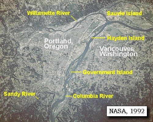
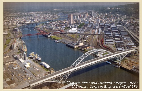
Portland, Oregon:
In 1843, Tennessee drifter William Overton and Massachusetts lawyer Asa Lovejoy beached their canoe on the banks of the Willamette River. Overcome by the beauty of the area, Overton saw great potential for this mountain-ringed, timber-rich land. His only problem was that he lacked the 25 cents needed to file a land claim. So, he struck a bargain with Lovejoy -- In return for a quarter, Overton would share his claim to the 640-acre site known as "The Clearing." Soon bored with clearing trees and building roads, Overton drifted on, selling his half of the claim to Francis W. Pettygrove. The new partners, Lovejoy and Pettygrove, couldn't decide on a name for their new township. Lovejoy was determined to name the site after his hometown of Boston, Massachusetts, while Pettygrove was equally adamant about his native Portland, Maine. They decided to flip a coin, now known as the "Portland Penny", to settle the argument. Pettygrove won on two tosses out of three. Lovejoy and Pettygrove were confident that Portland, with its deep water and abundant natural resources, would one day become a popular and prosperous port. Portland was officially incorporated on February 8, 1851, and today covers 130 square miles. -- Portland, Oregon Visitor's Association Website, 2003


Map, 1853, Washington and Oregon and the Columbia River, click to enlarge Image, 1988, Willamette River and Portland, Oregon, click to enlarge
  1. 1853 Map, Washington and Oregon and the Columbia River, from the Clearwater River to the Snake River and down the Columbia River to the Pacific Ocean (section of original). (Click to enlarge). Includes: Clearwater River (Kooskooski), Lapwai Creek (Lapwai R.), Snake River (Saptin or Lewis R.), Columbia River (Columbia R.), Yakima River (Yakima R.), Walla Walla River (Wallawalla R.), Umatilla River (Umatilla R.), Willow Creek (Quesnells R.), John Day River (John day's R.), Deschutes River (Fall R.), Willamette River (Willammette R.), and Cowlitz River (Cowlitz R.). Original Map: "Map of California, Oregon, Washington, Utah, and New Mexico (1853)", by Thomas Cowperthwait & Co. Washington State University Archives #WSU22. -- Washington State University Library Collections Website, 2003
  2. 1988 view of the Willamette River and the city of Portland, Oregon. Looking south with the Fremont Bridge in the foreground. (Click to enlarge). U.S. Army Corps of Engineers Photograph #Sce0373. Photograph Date: June 1988. Photographer: Bob Heims. U.S. Army Corps of Engineers Photo Archives. -- U.S. Army Corps of Engineers Website, 2002


In order to verify this information, captain Clarke persuaded one of the young men, by a present of a burning glass, to accompany him to the river [Willamette River], in search of which he immediately set out with a canoe and seven of our men. ......


Since the Chronology of this web presentation is following the Biddle/Allen publication, please see April 3, 1806 entry for further report of Clarke's April 2-3 journey up the Willamette River.


Along the Journey - April 2, 1806
The Camp - March 31 through April 5, 1806:
Cottonwood Beach, Washougal, Washington.


Clark's Camp of April 2, 1806:
Near Cathedral Park, St. Johns Bridge, Portland, Oregon. In the Biddle/Allen publication Captain Clark's description of his trip after his return to the main camp was written up on April 3, 1806.


Home Previous Continue


If you have questions or comments please contact: GS-CVO-WEB@usgs.gov
June/July 2004, Lyn Topinka
The Volcanoes of Lewis and Clark Home Page | CVO Home Page